
Managing Travel for Planned Special Events
Chapter Six. Traffic Management
Plan
Page 6 of 9
Traffic Flow Plan 
Overview
The preparation of a traffic flow plan represents a required preliminary step to the design of a traffic control plan. The traffic demand analysis component of a feasibility study indicates the freeway/arterial corridors and local streets that event patrons will utilize to access the venue site area. In developing a traffic flow plan, the event planning team modifies predicted flow routes to maximize transportation system operating efficiency on the day-of-event while meeting public safety agency needs. In turn, a traffic control plan facilitates traffic flow on recommended flow routes through service-enhancing strategies and tactics that handle forecasted event traffic demand on these routes.
The advantage of developing a traffic flow plan is two-fold:
- Allows the event planning team to influence and control event patron patterns of ingress and egress. This improves transportation system operations and reduces the impact to neighborhoods surrounding the event venue.
- Provides important advance information for event patrons and participants regarding best access routes to the event. These directions provide event patrons, particularly those not familiar with the region, an increased level of comfort when traveling on the day-of-event. Event patrons also recognize that the traffic management team will sign, staff, and prioritize flow on designated routes. Non-attendee transportation system users benefit by gaining advance notice of event-designated traffic and transit routes.
Information Requirements
Table 6-21 lists various sources of data and information that drive the traffic flow plan development process. Key points that should be considered include:
- A traffic flow plan should accommodate background traffic flow in addition to transit service, which will be promoted as an event patron travel alternative.
- Recommended traffic flow routes should not traverse or intersect emergency access routes, if possible.
- Event mandated road closures refer, in particular, to street use event
parade and race routes. If not already designated, the event planning
team should first determine the street use route.
- Table 6-22 provides a general checklist for evaluating the impact of closing one or more adjoining street segments, while Figure 6-29 shows a parade staging area.
- Typical staging areas include off-street parking areas and cross streets adjacent to the parade route.
- Upon reviewing the street closure checklist, the event planning team should consult with community interest stakeholders and public safety agencies in order to identify all concerns and solicit input.
| Element | Provision |
|---|---|
| One-way street operation |
|
| Impacts on access |
|
| Parade staging area |
|
| Coincidence with roadway construction |
|
| Proximity to major traffic generators |
|
| Presence of alternate routes for local access |
|
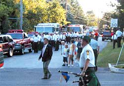
Figure 6-29. Parade Staging Area
Another key information component concerns the identification of roadway capacity deficiencies or bottleneck locations. This includes freeway weaving areas, freeway ramp junctions, freeway/street lane-drops, and intersection traffic control. Bottleneck locations yield a constant rate of flow (e.g., saturation rate), and appropriate traffic control strategies can temporarily alleviate the bottleneck on the day-of-event by increasing saturation flow rate. Consult the feasibility study roadway capacity analysis results or conduct new analyses to evaluate operations on traffic flow routes not previously considered. In addition, practitioners should consider driving, and creating a video/photo log, of proposed traffic flow routes, emergency access routes, and transit routes. This activity assists in verifying computer analysis results and facilitating off-site event planning team evaluation of recommended routes.
Strategic Route Planning
The traffic flow plan must account for two types of traffic flow routes: corridor and local:
- Corridor flow routes include the freeways and major arterial roadways serving the planned special event venue.
- Local flow routes traverse the street system adjacent to the event venue and service a particular parking area or pick-up/drop-off point.
- A target point represents the point of connection between
corridor and local flow routes, characterized by a freeway interchange
or major arterial intersection.
- In the driver's mindset, reaching a target point during event ingress signals entrance into the local area surrounding the event site. At this point, the driver anticipates receiving information and directions on event parking and pick-up/drop-off areas.
- During event egress, the driver's objective involves reaching the nearest target point (e.g., freeway interchange) in order to access a familiar corridor flow route leading toward home or some other destination.
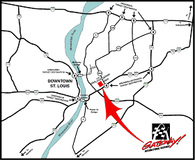
Figure 6-30. Corridor Target Points (Graphic courtesy of Dover Motorsports, Inc.)
- On the day-of-event, the management of corridor flow routes typically
involves surveillance and dissemination of traveler information regarding
target point and local flow route operations. The traffic management
team implements traffic control initiatives beginning at the target
point and continuing along the local flow route.
- Figure 6-30 displays a traffic flow plan that indicates, for reference by event patrons, various target points for access to individual venue parking areas.
Table 6-23 indicates general considerations for developing traffic flow routes. Figure 6-31 shows one corridor flow route spawning, via two target points, three local flow routes destined to the same venue access point. The figure demonstrates how a traffic flow plan works to assure that traffic demand on the existing street system adjacent to an event venue does not exceed capacity on the day-of-event if signed and staffed appropriately.
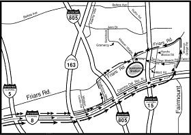
Figure 6-31. Multiple Local Traffic Flow Routes (Graphic courtesy of the City of San Diego.)
Figure 6-32 describes a process for assessing corridor and/or local traffic flow routes. Traffic control strategies for increasing corridor route capacity include eliminating weaving areas or other ramp control tactics. Strategies for local routes include striping additional travel lanes to handle flow in the predominant direction, restricting turning movements, and revising traffic signal timing plans. The "Traffic Control Plan" section of this chapter describes these strategies and other mitigation alternatives in greater detail.
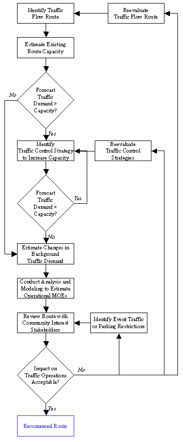
Figure 6-32. Traffic Flow Route Assessment Process D
Aside from parking contingencies and the occurrence of severe congestion on the day-of-event, practitioners should maintain and promote the same flow routes identified in the traffic flow plan. These routes are generally pre-signed and communicated to event patrons and participants prior to the event. Measures of effectiveness for evaluating the performance of designated traffic flow routes, in additional to corresponding traffic control strategies, include: (1) time to regain free-flow operations and (2) time to clear parking areas.
Alternate Routes
The deployment of an alternate route plan marks a key traffic management strategy for minimizing the effect of non-recurring congestion, caused by a traffic incident or event-generated traffic demand, on traffic flow. It serves to reduce demand at a traffic incident site or bottleneck through the diversion of traffic from the mainline to parallel freeways, arterials, and streets. As part of traffic incident management efforts, some jurisdictions may maintain alternate route plans for freeway and arterial segments traversing a region.
An alternate route plan represents a contingency plan that stakeholders should consider developing for corridors serving a planned special event venue, where high-speed crashes or cargo spills may block travel lanes for a long duration. In other instances, an alternate route plan becomes a critical component of the overall event traffic management plan when roadway or bridge construction activities limit the capacity of mainline corridor flow routes. Transportation system operators should also promote travel choice alternatives, such as using other travel modes, as an option to driving alternate routes.
The process of developing alternate route plans and procedures for plan deployment requires a group endeavor involving all affected agencies, most of which likely comprise the event planning team and/or traffic management team. Table 6-24 lists the steps required in developing an alternate route plan. Practitioners should consult NCHRP Synthesis 279, Roadway Incident Diversion Practices, for state-of-the-practice information about the development and deployment of alternate route plans.(13) Table 6-25 highlights numerous considerations in alternate route plan development, all of which are addressed in the cited synthesis report.
Figure 6-33. Background Traffic Diversion
The effectiveness of deploying an alternate route plan revolves around the accommodation of diverted traffic along the alternate route. It is essential that the diverted traffic encounter an equal or higher level of service on the alternate route compared with that on the mainline. As shown in Figure 6-33, alternate route plan deployment, particularly plans developed specifically for a planned special event, typically requires significant law enforcement resources for alternate route traffic management and operations surveillance. Technology applications for managing traffic on an alternate route, and reducing field personnel requirements, include the installation of dynamic route guidance signs controllable from a transportation operations center. Figure 6-34 shows a dynamic trailblazer sign. During the program planning phase, stakeholders managing recurring planned special events at permanent venues should evaluate the need for installing these devices along commonly used alternate routes serving the event venue.
Emergency Access Routes
Emergency access route planning involves designating street closures within the venue site area to connect the some or all of the following termini: (1) public safety (e.g., fire and emergency medical service) headquarters, (2) local hospital, (3) freeway or major arterial serving a regional hospital, and (4) location of staged ambulances and first-aid stations for on-site medical treatment.
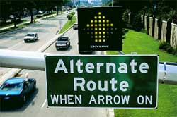
Figure 6-34. Dynamic Route Guidance Sign (Photo courtesy of the Minnesota DOT.)
For large-scale planned special events, emergency access routes remain closed to all non-emergency vehicles. Traffic control officers staff each intersection along the route and permit side street traffic to cross the route when conditions permit. For smaller-scale special events, the emergency access route denotes a local flow route for emergency vehicles that may be utilized by general traffic under non-emergency conditions. Under an emergency scenario, law enforcement officers may escort emergency vehicles, using a rolling roadblock, via the designated access route. Emergency access routes should not traverse or intersect event patron traffic flow routes to/from the event venue and associated parking areas.
The provision of emergency access lanes along streets slated for closure in order to stage a planned special event allows unimpeded emergency vehicle access throughout the entire local street network impacted by the event. This particularly applies to street use event routes. Typical specifications for an emergency access lane involve delineating a 20 foot wide, paved curb lane within the existing roadbed (e.g., shoulder plus traveled-way).
Background Traffic Accommodation
The composition of background traffic, or non-attendee motorists, traversing streets and highways in the vicinity of a planned special event venue include the following categories:
- Regional through traffic
- Includes truckers and intra- or interstate travelers represent regional through traffic.
- Local through traffic
- Includes commuters and area residents, some of whom may simply cruise local streets adjacent to the event.
- Neighborhood residents and businesses
- Includes residents living in the immediate vicinity of the event venue that may incur impacts attributed to high traffic demand and temporary traffic control strategies.
- Includes nearby businesses requiring accommodation for both employees and patrons.
Table 6-26 presents a range of passive (e.g., traveler information dissemination only) and aggressive (e.g., physical traffic control) tactics for accommodating background traffic during a planned special event.
Freeway-to-Freeway Diversion
Transportation management system operators can implement freeway-to-freeway diversion through control of permanent changeable message signs and highway advisory radio.
Parking Restrictions
Parking restrictions accomplish the task of preventing event-generated traffic from deviating from local event traffic flow routes and traversing neighborhood residential and commercial areas.
Traffic Control Points
Road closures may impact customer access to businesses and other traffic generators. Figure 6-35 shows a sign diverting traffic destined to a major traffic generator located adjacent to a planned special event temporary venue.

Figure 6-35. Accommodation of Traffic Destined to Major Generators
Large-scale events may generate sufficient traffic demand to saturate the entire local street system adjacent to the event venue, causing undue congestion and blocking neighborhood access and circulation patterns. If this represents a potential concern during advance planning, then locate event parking areas a sufficient distance away from affected neighborhood areas and create traffic control points to prevent event-generated traffic from penetrating these areas. Residents and business employees would receive a pass allowing them access through the traffic control points.
Arterial-to-Arterial Diversion
Arterial-to-arterial diversion applies to planned special events occurring in city downtown or commercial areas, where arterials and local streets adjacent to the event venue serve a significant volume of background traffic. In turn, the addition of event-generated traffic causes congestion and impacts commercial businesses (e.g., restaurants, hotels, retail stores). This tactic involves: (1) restricting commercial street access to businesses employees, customers, emergency vehicles, taxis, and transit buses and (2) deploying an alternate route to direct background through traffic and event-generated traffic around the restricted street.
Planned special event stakeholders in Atlanta, Georgia developed such an alternate route, entitled the "Blue Loop" to divert traffic away from restricted Peachtree Street during special events in downtown Atlanta.(14) Stakeholders prepared the plan during the program planning phase in response to lessons learned from past planned special events that occur in the Atlanta downtown area and generate significant automobile traffic. They hope the term "Blue Loop" becomes an alert that city residents will recognize and understand that the alternate route is in effect. Traffic monitoring represents a key to Blue Loop operation, and the route deployment detail specifies several release points for diverting Blue Loop traffic to adjacent highways.
Street use events involving a parade or road race permit the traffic management team to reopen certain roadway sections after event participants pass, even if the event has not completed. Background traffic accommodation includes disseminating specialized traveler information, summarized in Table 6-27, prior to the event. The information provides non-attendee transportation system users a timeframe, relative to the parade/race pace and field length, that certain route sections will be closed. Otherwise, travelers may mistakenly assume that the entire street use event route will remain closed for the duration of the parade or road race.
Transit Accommodation
A traffic management plan that prioritizes bus flow to and from the venue site area positively influences the utility associated with transit and other travel choices involving express bus, charter bus, or shuttle bus transport. Transit agencies should operate on scheduled bus transit routes up until the last possible point to divert around a road closure required to stage a planned special event. This avoids user confusion and minimizes inconvenience to non-event attendees.
Table 6-28 lists tactics for accommodating scheduled and event-generated bus service.
| Tactic |
|---|
|
Exclusive Bus Route
Exclusive bus routes that cause a negligible impact to background traffic and adjacent neighborhoods represent the recommended bus accommodation tactic. Advantages of exclusive bus routes include: (1) use of the same route during ingress and egress, (2) increased mobility and travel time reliability, and (3) better venue station accommodations for riders as temporary stations may exist adjacent to bus routes, thus avoiding conflicts with event vehicle and pedestrian traffic.
Depending on roadway network layout, a special event traffic flow plan may feature an exclusive bus route from corridor target points and satellite parking areas direct to designated pick-up/drop-off areas adjacent to the venue. Other bus routes may only divert buses around known bottleneck locations. Figure 6-36 shows an exclusive bus route implemented for a major rural planned special event. An exclusive bus route must accommodate minimum overpass height requirements, vehicle weight requirements, and vehicle turning radii.
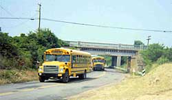
Figure 6-36. Exclusive Bus Route
Exclusive/Priority Bus Lane
An exclusive bus lane represents a travel lane for bus traffic only. Temporary applications include converting an existing roadway shoulder or travel lane for bus use during a planned special event. Table 6-29 summarizes drawbacks associated with the temporary operation of an exclusive bus lane. A bus priority lane is used by both buses and general traffic between intersections. However, at intersection approaches such as that shown in Figure 6-37, regulations limit general traffic to a turning movement, while buses can continue straight through the intersection and "jump" adjacent through-lane queues.
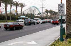
Figure 6-37. Bus Priority Lane
On-Demand Communication
On-demand communication with a command center represents another bus accommodation tactic that the traffic management team may employ in conjunction with other previously discussed tactics. Bus operations supervisors or other traffic management team personnel, stationed at the TMC or event command post, monitor roadway surveillance sources (e.g., CCTV and field observers) in order to identify areas of congestion before a bus encounters it. When supervisors verify a traffic bottleneck affecting a bus route, they immediately notify bus operators and work to divert buses around the congested area.
Plan Specifications
The traffic flow plan serves stakeholders managing the planned special event in addition to event patrons and participants. The product of strategic route planning involves informing event patrons of best access routes to and from the planned special event. Stakeholders can communicate preferred route directions via: (1) event patron ticket mailings, (2) media public information campaigns, and (3) event, venue, or traffic information websites.
Table 6-30 contains a traffic flow plan development checklist.
Appendix I contains example traffic flow maps prepared for various planned special events.(15)
Traffic flow plans should emphasize available express, charter, and shuttle bus services from regional park and ride lots and/or satellite parking areas. Driving directions should be accompanied by useful travel tips that coincide with the day-of-event operation of recommended traffic flow routes. Travel tips include accessing en-route traveler information and adhering to traffic control tactics.
Planned Special Events Traffic Management | Privacy Policy