Applying Transportation Systems Management and Operations to Rural Areas
Chapter 8. Application of TSMO Strategies to Rural Work Zones
What Are Work Zones?
Work zones are areas where construction, utility, or maintenance work is being conducted, typically involving lane closures, moving equipment, and detours. Work zones can be challenging in rural areas where there may be limited or no alternate routes, and where weather may limit work seasons to times of peak tourism.
Technology, such as smart work zones, can use site-specific traffic control technology within a work zone to provide real-time travel information to motorists. For example, radar speed display signs, as shown in figure 10, are effective in slowing down motorists approaching a work zone. FHWA has a developed a CMF and several case studies for work zone management.33
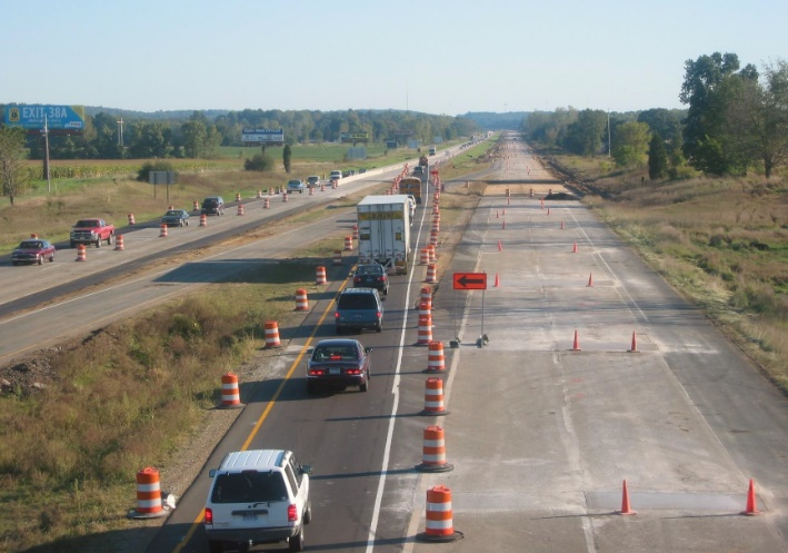
Figure 10. Photo. Rural construction zone.
Source: FHWA.
Example Strategies
Examples of TSMO strategies used as part of work zone management include:
- Smart work zone systems with DMSs, video cameras, and radar to provide motorists with real-time traffic updates as they approach a work zone.
- Where stopping is mandatory in a work zone, require drivers to turn on their emergency warning flashers to alert following vehicles of the work zone stopping condition.
Potential Benefits
Potential benefits of using TSMO strategies in work zone management include:
- Enhanced safety for road users, construction workers, and work zone personnel.
- Reduced potential for aggressive maneuvers at work zones.
- Improved ability to react to stopped or slow traffic.
- Reduced impact on worker productivity.
Common Questions to Consider
Common questions to consider when using TSMO strategies in work zone management:
- If detours are necessary to reroute traffic, has the length and travel time delay (which can be significant in rural areas) been considered?
- Can work be scheduled to avoid the biggest impact periods (e.g., major annual festival)?
- Are there strategies to divert traffic on alternate routes to avoid travelling through a work zone, where possible?
- Is there equipment available, such as portable flaggers or signals, to avoid having personnel on the road?
- Since advance signing for work zones can stretch over a longer distance, evaluate setup, move, and take-down efforts.
Table 11 and table 12 present two case studies related to work zone strategies in rural areas. Information about impacts to travel time can be displayed on permanent variable message signs (VMSs) in advance of the work zone so that long-distance travelers have a chance to divert to avoid possible delays.
Table 11. Oregon Department of Transportation Work Zone Intelligent Transportation System Equipment Case Study.
| Oregon Department of Transportation Work Zone Intelligent Transportation System Equipment Case Study. |
 Project Description and Goals Project Description and Goals
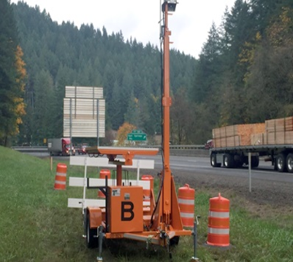
Figure 11. Photo. Portable intelligent transportation systems trailer.
Source: FHWA.
Oregon DOT used work zone ITS equipment for a 6-mile highway project that reduced lanes to one per direction for pavement and bridge preservation. The project is located on I-5 near the border of Oregon and California, where there is 6-percent grade and 30-percent truck traffic. The amount of freight along this corridor was a priority concern for this project. The project used two portable solar-powered ITS trailers, shown in figure 11, with wireless technology, to detect and collect on-site data (e.g., delay, volumes, vehicle classification, speed). The data were sent to transportation managers and travel time information was provided to motorists via DMS.
|
|
 Benefits Benefits
Remote data collection: Work zone ITS included sensors and cameras that remotely collected data and provided real‑time travel time information to drivers on message boards.
Real-time information: The portable ITS trailers measure travel time between trailers (6–8 miles apart) and send the information to portable changeable message signs, as well as an online database that provides real-time images and traffic information the public can view.
Improved coordination: Cameras and sensors in rural areas allow staff and maintenance crews to better understand current conditions and potential incidents that may arise.
|
|
Challenges
Issues with pan-tilt-zoom cameras: Using cellular service will limit frame rate of video; controlling camera movement is more difficult with slower communication speeds.
Power: Portable units rely on solar power, and sometimes there is no sunlight for long periods of time in the Northwest.
Vandalism/damage: Although most equipment is locked, cases of theft of batteries or solar panels generate maintenance and replacement costs. The portable equipment needs to be removed during winter due to the potential of being buried in snow or damaged by snowplow operation. |
 Lessons Learned Lessons Learned
- Design the size of the portable ITS trailer’s solar panels to work year-round, including the winter.
- Place the cameras and sensors very high on the portable units to avoid theft.
- Collaborate with resident engineers and maintenance crews to maximize use of the system.
|
Table 12. Missouri Department of Transportation Rural Queue and Delay Warning Systems Case Study.
| Missouri Department of Transportation (DOT) Rural Queue and Delay Warning Systems (RQDWS) |
Project Description and Goals
In January 2016, Missouri DOT implemented RQDWS. In 2017 it was awarded Best Project from ITS America’s Heartland Chapter. The RQDWS was initially implemented along rural I-70 to automatically warn motorists via dynamic message signs (DMSs) of slow or stopped traffic ahead. In rural areas, congestion and queues can be especially unexpected. The goal of the project was to improve safety by notifying high-speed motorists, especially freight traffic, about upcoming slow or stopped traffic in a work zone. Previously, transportation managers had to rely on public phone calls or have cameras operating in the area to know traffic conditions, which can often be subjective.34 In contrast, the RQDWS relies on GPS-based live traffic probe data to feed data into the advanced traffic management system, which uses vendor-specific software. The data are compared with the preset threshold for slowed traffic, and appropriate messages are automatically posted to a rural DMS. Missouri DOT has existing DMSs every 10–20 miles along State corridors in rural areas.
Missouri DOT’s Information Systems Department also developed a complementary field traffic alert system where contractors and Missouri DOT staff can sign up for email and text alerts when speeds drop below a certain threshold along the highway corridor. The location and speed threshold are customizable so users can easily set up and configure alert notifications where work zone queues are anticipated. Statewide probe data power all DMS, text, and email notifications and provide a high level of work zone situational awareness for traffic management centers, Missouri DOT staff, and contractors.
|
Benefits
Automatic updates: The software automatically updates the appropriate queue warning messages to the DMSs without any action needed.
Improved safety: High-speed secondary crashes at the back of traffic queues are a primary crash concern in Missouri. This warning system can prevent future collisions by notifying drivers of slowdowns ahead.
|
Challenges
Costs: Implementing ITS systems can involve significant resources.
|
Lessons Learned
- Build upon existing infrastructure: Missouri DOT had an extensive DMS system in rural areas it could use to deploy warning messages. When a bridge collapsed, operational staff were able to notify travelers within a 200-mile radius of the bridge closure using DMSs. Missouri DOT staff worked with software consultants to integrate its existing automatic vehicle location systems, rather than purchase new transponders. Automatic vehicle location systems use GPS to remotely report vehicle information such as location, speed, and stops.
- Using the data: Missouri DOT has existing trucks specifically outfitted with additional traffic control equipment. It uses the trucks to travel the congested areas to verify traffic probe data and confirm traffic conditions with operational staff. Conditions may change between sensor locations, and these trucks can provide additional information.
|