Applying Transportation Systems Management and Operations to Rural Areas
Chapter 6. Application of TSMO Strategies to Rural Road Weather Management
What is Road Weather Management?
Weather events can impact roadway mobility and safety by increasing travel time delays and increasing crash risk and exposure to weather related hazards. Informing and managing evacuating traffic from natural disasters, such as hurricanes, forest fires, and flooding, can be more challenging in rural areas. Road weather management strives to mitigate weather related impacts by implementing three types of strategies: advisory, control, and treatment.28 Advisory strategies involve predicting weather conditions and providing that information to transportation managers and travelers. One way to do this is by using DMSs, as shown in figure 6. Control strategies involve regulating or restricting traffic flow. Treatment strategies supply resources to roadways to reduce or eliminate weather impacts (e.g., providing snowplows and salt trucks). FHWA has a developed a CMF and several case studies specifically for road weather management.29
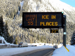
Figure 6. Photo. Dynamic message signs in Washington.
Source: FHWA.
A permanent, pole-mounted dynamic message sign warning over a snowy roadway that warns drivers that there is ice in places. It also advises drivers that the temperature is 23 degrees and the speed limit is 55.
Example Strategies
Examples of TSMO strategies used as part of road weather management include:
- Flashing beacons for active warning tied to road weather monitoring systems.
- DMSs to provide real-time traveler information about weather and pavement conditions.
- Speed advisory messages that are activated by weather conditions and/or specific vehicle speeds.
Potential Benefits
Potential benefits of using TSMO strategies in road weather management include:
- Improved road user safety through early weather detection and warning in rural areas that generally have higher speeds.
- Improved pre-trip planning due to quality real-time information; rural areas usually have less up-to-date information and less granularity.
- Limited road weather equipment and resources for greater efficiency.
- Mitigating the impact winter maintenance can have on the environment.
- Improved travel time reliability and fewer unexpected delays. Improved information allows management strategies to be employed sooner in areas that may require more travel time to reach due to their rural location.
Common Questions for Agencies to Consider
Common questions for agencies to consider when using TSMO strategies in road weather management:
- Is there a method to collect and share information about road conditions or road closures?
- Is there a way to monitor and/or maintain rural areas that lack surveillance or sensors to collect road surface condition data?
- Is there a plan to inform and manage traffic evacuation in the event of a natural disaster such as hurricane, forest fire, or flooding?
- Is there a management plan for snowplow operations over a large geographical area?
Table 7 and table 8 provide two case studies related to road weather management strategies in rural areas. One case study integrates the specific needs in the rural area within a statewide strategy, and the other institutes a traffic operation center dedicated to the operations of the rural areas of the State.
Table 7. Washington State Department of Transportation Strategic Plan Case Study.
| Washington State Department of Transportation (WSDOT) Strategic Plan. |
 Project Description and Goals Project Description and Goals
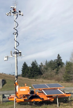
Figure 7. Photo. Portable environmental sensing station unit.
Source: WSDOT.
WSDOT wanted to provide better road weather information to support its transportation goals, so it implemented road weather information system (RWIS) devices, both fixed and stationary. Through its strategic plan WSDOT is providing travelers a safe and integrated multimodal system. A large portion of this plan revolves around the issues related to rural areas. The WSDOT Strategic Plan30 was developed to provide travelers with the most information, as soon as possible, and continue to move goods and services throughout the State. The WSDOT mission is to provide safe, reliable, and cost-effective transportation options to improve communities and economic vitality for people and businesses. Multi-agency collaboration with traffic maintenance centers, snowfighter groups charged with removing snow from roads, and Pathfinder proactive transportation system management strategies used ahead of and during weather events, helped achieve many of the goals outlined in WSDOT’s Strategic Plan.
|
|
 Benefits Benefits
Pre-trip planning: Partnerships were developed with a company that provides weather decision support services, the National Oceanic and Atmospheric Administration (NOAA), WSDOT Public Information Office, TMCs, and maintenance management (headquarters and region) to determine and synchronize travel condition messaging, weather forecasts, and travel alerts.
Winter operations dashboard: WSDOT uses internal displays that provide snowfall amounts, automated vehicle location data, equipment deployed, and other snow-fighting information in real time.
RWIS: Provides valuable information and forecast analytics from the meteorological community that helps WSDOT prioritize where to deploy snowplows. The public can access the information to aid with route planning.
|
|
Challenges
Determining where to install limited resources: As seen in figure 7, WSDOT’s RWIS network consists of 105 permanent environmental sensing stations (ESSs) and several portable ESS units with varying costs. Being specific as to where the sites are located takes a lot of communication.
Determining maintenance: Clarifying who is responsible for maintaining and calibrating ESS sites.
Determining funding: Ensuring there is enough funding for maintenance and upgrading or replacing existing equipment.
Determining replacement: Developing a process for the replacement cycle of ESS sites as they age or become obsolete.
Improving visualization: The current software needs to be upgraded for better graphics and user experience.
|
 Lessons Learned Lessons Learned
- Consider routine maintenance and calibration costs: If routine maintenance is not considered or performed, inaccurate ESS observation data can degrade confidence in the system.
- Implement communication improvements: Among all stakeholders, work together to refine site locations, enhance maintenance of existing sites, and regularly calibrate equipment.
- Train employees: Develop a training program to reduce impacts of turnover to include maintenance of the ESS sites, users of the data, and WSDOT leadership to help achieve the goals and objectives of the strategic plan.
- Continue collaborations: Continue to maintain and expand collaborations as needed.
- Prepare for the future: Consider future process enhancements such as variable speed limits and advanced traffic management systems to improve existing systems.
|
Table 8. Montana Department of Transportation Rural Transportation Management Center Case Study.
| Montana Department of Transportation (DOT) Rural Transportation Management Center (TMC) |
Project Description and Goals
Montana’s rural TMC provides 24-hour, year-round support for maintenance operations for all Montana DOT employees for all five districts and statewide support for emergency providers. The centralized TMC was created to improve the frequency and consistency of travel-related messaging. This center also provides an organization base for future ITS implementations. The goal of the TMC is to provide better information to the public and improve tracking of agency resources. In 2019, seven new full-time positions were approved to improve staffing. Existing positions were transitioned from the five divisions to headquarters to centralize operations. Also, Montana DOT used the new positions to hire six permanent dispatchers and a communications technician.
The TMC communicates weather and roadway conditions primarily from visual observation by Montana DOT field staff and data provided by 76 ESS sites throughout the State. The RWIS is helpful for assessing road surface conditions, wind speeds, wind direction, and air and surface temperature.
|
|
Benefits
Standard operating procedure: Montana DOT developed comprehensive standard operating procedures to appropriately train staff. This improved consistency and communication with local emergency providers and State and local law enforcement.
Improved relationships: The TMC staff is now on a first-name basis with many law enforcement officials, which improves efficiency and communication to deploy appropriate resources and messaging about incidents and maintenance needs. There are approximately 50 different 9‑1-1 centers in the State, and it is key to have open and effective communication with them.
Preemptive messaging: Relationships with the NOAA, the Pathfinder program, and the four weather service operations in Montana have improved the ability to forecast weather and provide information to travelers in real time via DMS. In winter 2021, Montana DOT was able to post 36 preemptive events compared to the previous year, where only 20 events were posted.
|
|
Challenges
Winter coverage: Prior to implementing the TMC, 24-hour per 7 days office coverage only existed between November and March (the winter road condition reporting season). During the remainder of the year, radio coverage (e.g., analog with relays) only existed during normal business hours.
Communications: Radio coverage was a major challenge to centralizing the TMC. Radio coverage was acceptable at the district level, but not Statewide. By adding specialized hardware in many of the field offices, incoming radio signals were digitized and sent over the network to the TMC. Each dispatcher radio console costs approximately $40,000. The TMC purchased seven consoles. Emergency medical services and the Montana Highway Patrol need to be able to easily contact the TMC at any time. The TMC has a phone number primarily used by these agencies to communicate with Montana DOT.
Network reliance: Although there are backup generators and a backup phone line in case of power outages, if there is long-term network failure, TMC operations would temporarily revert to the districts.
|
Lessons Learned
- Create a career ladder and operating procedures: Develop promotional opportunities to increase staff retention and reduce turnover. TMC staff have clear operating procedures, roles, and responsibilities periodically updated over time.
- Increase temporary staff: Workload during the winter road condition reporting season is much greater due to an increase in field staff and weather affecting travel conditions. To address the added workload, Montana DOT supplements full-time staff with trained temporary workers. Hiring more workers at less than full time provides flexibility to staff up during storms and reduces stress on the permanent workforce.
- Improve existing systems: Rather than replace all radios in the existing truck fleet with newer models, TMC staff installed additional radio hardware, which was used to digitize incoming analog signals and transmit them over the State network using radio over internet protocol.
- Improve existing processes: Montana DOT is working to improve its check-in and check-out processes for drivers to make it more efficient when snowplow drivers enter and leave service. For safety, drivers are required to check in and out of service any time they are working outside normal business hours. This often occurs statewide at the same times, creating a communication bottleneck. Montana DOT will use new software and pilot handheld devices in snowplows to improve check-in and check-out efficiency.
|
|