Applying Transportation Systems Management and Operations to Rural AreasChapter 5. Role of Emerging Trends and TechnologyEmerging technology creates new opportunities to address rural transportation challenges. It is important for agencies to understand technologies available today, and plan and design implementations to leverage future technologies. TrendsTransportation Network CompaniesDifferent types of trips are made every day—from a rural area to an urban area, internal to the rural area, and through the rural area. Not all of these trips can be supported by rural areas. For example, public transit usually stays within the urban areas, limiting the available mode choice of people living in rural areas, especially those who do not have access to personal vehicles. Transportation network companies (TNCs) are an increasingly popular alternative to driving a personal vehicle. TNCs use online platforms, often a smartphone application, to connect passengers to drivers who provide on-demand rides based on real-time information. TNCs can enable one passenger or a group of passengers to share a vehicle based on similar origins and destinations. By ridesharing, passengers can travel to and from special events in rural communities, which can reduce post-event congestion. Also, ridesharing services can reduce the potential of impaired driving on rural roads after recreation or social activities. TNCs can be used in rural areas to provide an alternative transportation choice where there are limited transit routes or mobility options. Table 2 presents potential benefits, challenges, key components, and an example use case of transportation network companies.
Crowdsourced DataCrowdsourcing involves collecting data from a large sample of people. Typically, data are gathered from the internet or mobile applications that use a global positioning system (GPS) on a smartphone to follow user movements.15 Crowdsourced data can provide real-time information about weather conditions, potholes, incidents, and travel time delays in areas that cannot be monitored regularly. Crowdsourced data systems are a relatively low-cost solution for rural locations compared to installation of vehicle detector infrastructure, especially for agencies with limited staff and technology deployments to monitor rural transportation networks. Table 3 presents potential benefits, challenges, key components, and examples of crowdsourced data.
Broadband CommunicationsHigh-speed telecommunications (HST), also known as broadband, can have a large impact on society, especially in rural communities. HST aims to provide dependable, high speed internet, which is key for individuals living in rural communities. Broadband can support transportation needs and can play an important role in strengthening economic development. A study conducted in 2007 found that implementing broadband in rural communities showed an increase of 1–1.4 percent in population growth rate and an increase of 0.5–1.2 percent in the number of businesses over a 4-year period.18 Due to limited communications infrastructure, adults who live in rural areas remain less likely than urban or suburban adults to have home broadband or own a smartphone. Laying fiber lines and setting up related infrastructure can require funds that can be burdensome for rural residents. Data from the Federal Communications Commission show rural areas are less likely to be wired for broadband services and tend to have slower internet speeds compared with other areas of the country.19 There are also fewer broadband providers operating in rural areas, which means consumers tend to have limited options when subscribing to high-speed services. A key factor for successfully implementing HST is public-private partnerships. There are efforts in several States to share public right-of-way to foster development of broadband communications. Expanding broadband communications will allow transportation agencies to connect to existing cellular-only devices or add new TSMO strategies or devices in rural areas that have no current communications available. Reliable internet facilitates efficient and reliable communication between different ITS devices and traffic management centers (TMCs). Table 4 presents potential benefits, challenges, key components, and an example of a broadband communication study.
TechnologiesConnected VehiclesTechnology is a powerful tool for addressing transportation challenges in rural areas, where resources are scarce, maintenance and operations of transportation systems can be costly, and information about large geographic areas can be difficult to collect. One emerging technology that may benefit rural areas is connected and automated vehicle technology. Connected and automated vehicle technology, as seen in figure 5, enables cars, trucks, buses, and other vehicles in the traffic stream to communicate with each other, surrounding infrastructure, and smartphones. 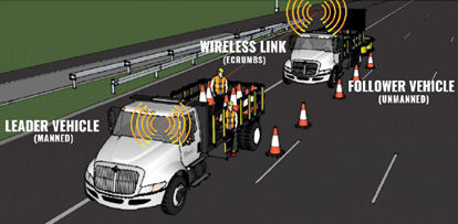
Figure 5. Illustration. Minnesota Department of Transportation testing an autonomous vehicle. Artist's illustration shows two connected vehicles. Both are trucks with open cargo spaces behind the cab. In the first truck, two people are in the cargo area along with a number of construction cones. A series of these cones are on the pavement along the demarcation line separating the lane where the vehicles are from the travel lane beside it. The first vehicle is labeled 'leader vehicle (manned)'' and the second labeled 'follower vehicle (unmanned).'' The two are connected via a wireless link ('ecrumbs').
With connected and automated vehicle technology, signals are transmitted through a wide range of platforms to provide information about other vehicles (vehicle-to-vehicle) and surrounding infrastructure (vehicle-to-infrastructure). The infrastructure contains sensors that gather real-time traffic information, which is then transmitted to connected vehicles, smartphones, or GPS devices. Connected vehicles could dramatically improve safety by warning drivers in rural areas about nearby hazards such as a traffic light about to turn red, dangerous driving conditions, sharp curves, or merging vehicles. Use of autonomous vehicles during routine roadway maintenance activities, such as roadway striping or shoulder repair, can also improve safety by removing maintenance workers from active work zones. Table 5 presents potential benefits, challenges, key components, and examples of connected vehicle deployments.
Unmanned Aerial SystemsUnmanned aerial systems (UAS) are aircrafts that operate by a remote control or an onboard computer. UAS can be used for evaluating road conditions in hazardous locations, monitoring traffic, mapping unpaved roads, or inspecting existing infrastructure (e.g., underneath bridges). These devices can also be used for emergency services such as aerial observation (e.g., scene of a crash or wildfire detection) or search-and-rescue efforts to scout areas with difficult terrain. During or after natural disasters, such as floods, UAS can deliver medical supplies and allow those in need to communicate with medical personnel. Table 6 presents potential benefits, challenges, key components, and an example of an UAS.
14 Ranjit Godavarthy and Jill Hough, Opportunities for State DOTs to Encourage Shared-Use Mobility Practices in Rural Areas, National Cooperative Highway Research Program (Washington: December 2019), http://onlinepubs.trb.org/onlinepubs/nchrp/2065/Task76Report.pdf. [ Return to Return to Note 14 ] 15 “Rural Intelligent Transportation System (ITS) Toolkit,” National Center for Rural Road Safety, https://ruralsafetycenter.org. [ Return to Return to Note 15 ] 16 "511 Idaho," Idaho Transportation Department, accessed May 1, 2021, http://511.idaho.gov/. [ Return to Return to Note 16 ] 17 Aaron Marsh, "Crowd-Souring Helps App Get around Parking Data Limitations," FleetOwner, November 5, 2015, https://www.fleetowner.com/technology/article/21692143/crowdsourcing-helps-app-get-around-parking-data-limitations. [ Return to Return to Note 17 ] 18 FHWA, Rural Interstate Corridor Communications Study (Washington: August 2007). [ Return to Return to Note 18 ] 19 Federal Communications Commission, 2015 Broadband Progress Report (Washington: February 2015), https://www.fcc.gov/reports-research/reports/broadband-progress-reports/2015-broadband-progress-report. [ Return to Return to Note 19 ] 20 Federal Communications Commission, 2021 Broadband Deployment Report (Washington: January 2021), https://www.fcc.gov/document/fcc-annual-broadband-report-shows-digital-divide-rapidly-closing. [ Return to Return to Note 20 ] 21 USDOT, Intelligent Transportation Systems (ITS) Benefits for Rural Communities, https://www.its.dot.gov/factsheets/pdf/Rural.pdf. [ Return to Return to Note 21 ] 22 USDOT, Intelligent Transportation Systems Benefits. [ Return to Return to Note 22 ] 23 FHWA, Rural Connected Vehicle Gap Analysis: Factors Impeding Deployment and Recommendations for Moving Forward, FHWA-JPO-18-612, (Washington: August 2017), https://rosap.ntl.bts.gov/view/dot/34723. [ Return to Return to Note 23 ] 24 FHWA, Rural Connected Vehicle Gap Analysis. [ Return to Return to Note 24 ] 25 “CV Pilot Deployment Program,” Intelligent Transportation Systems, accessed May 1, 2020, https://www.its.dot.gov/pilots/wave1.htm. [ Return to Return to Note 25 ] 26 Rachel Riley, “Colorado Paves Way for ‘Vehicle-to-Everything’ Highway Pilot,” The Gazette, January 7, 2019, https://www.govtech.com/fs/transportation/colorado-paves-way-for-vehicle-to-everything-highway-pilot.html. [ Return to Return to Note 26 ] 27 “Public Safety Implementation of Unmanned Aerial Systems for Photogrammetric Mapping of Crash Scenes,” Transportation Research Record 2673, no. 7 (2019): 567-574, https://journals.sagepub.com/doi/abs/10.1177/0361198119850804. [ Return to Return to Note 27 ] | |||||||||||||||||||||||||||||||||||||||||
|
United States Department of Transportation - Federal Highway Administration |
||