Unmanned Aircraft Systems for Traffic Incident ManagementChapter 3. Benefits of Unmanned Aircraft Systems for Traffic Incident ManagementThe following list represents some of the benefits of Unmanned Aircraft Systems (UAS):
Law enforcement has noted that having access to overhead images at crash scenes helps them better understand vehicle movement and the dynamics of the crash.16 Measurements from photographs is the major benefit for traffic crash investigation using UAS, as all users noted that UAS was much faster than any other scene measuring or mapping technique. While there are a number of mapping solutions available to law enforcement, UAS is the only one that typically does not require road/lane closure, and the only one that can be used without placing officers in travel lanes. In general, mapping with Total Station could involve 100 to 200 points, requiring up to two hours, and the roadway is often fully or partially closed for safety reasons. While 3D scanners create point clouds with millions of points, closing the road is routine with their use. UAS may take 100 to 200 photographs, containing millions of points in a 10- to 15-minute flight where the roadway can generally stay open. Collecting points with total station or scans with 3D scanners require more actions as scenes get larger or more complex. Additional points and scans require more time. Regardless of complexity, size of the scene, or number of vehicles, the UAS time is virtually the same for most traffic crash scenes. A study by the National Institute of Justice (NIJ) used technology at a staged traffic collision to determine accuracy of the approaches and to a lesser degree time savings. The NIJ study compared UAS with the use of both manual and robotic total stations and found that UAS was one hour faster than the robotic total station and two hours faster than the manual total station.17 The North Carolina Department of Transportation (NCDOT) and North Carolina State Highway Patrol (NCSHP) completed a field comparison that provides the most cited evidence that UAS represents a time savings over 3D laser mapping. The two approaches were the same from an accuracy standpoint, but the UAS approach demonstrated significant time savings. UAS was found to be 311 percent more efficient, requiring just 25 minutes to document a staged two-car collision, while the 3D scanner required one hour and 51 minutes.18 In a study with Purdue University, the Tippecanoe, Indiana Sheriff’s Office found that overall scene time was reduced by 60 percent with the use of UAS.19 In one example, the agency noted that an 800-foot crash scene was documented in a mere 22 minutes. The Washington State Patrol (WSP) has data that shows the effectiveness and value of UAS as a tool for actual traffic crash investigations during their 2018 pilot program.20 The WSP has documented more than 125 UAS deployments and found:
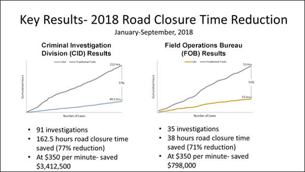
Figure 8 shows a graphic summary of the time savings for road closures with UAS compared to traditional tools.
Figure 8. Slide. Key results slide from Washington State Patrol presentation. A graphic summarizing the key findings from the Washington State Patrol 2018 pilot program. Key results: 2018 Road Closure Time Reduction, January to September 2018. Criminal Investigation Division (CID) results: 91 investigations, 162.5 hours of road closure time saved (77 percent), at $350 per minute – saved $3,412,500. Versus Field Operations Bureau (FOB) results: 35 investigations, 38 hours of road closure time saved (71 percent), at $350 per minute – saved $798,0000.
Time and safety create very compelling cases for clearing traffic incidents more quickly. The juxtaposition is the need for a complete and thorough crash investigation, particularly when there is a fatality and potential criminal charges. The concept of “safe, quick clearance” is a national traffic incident management (TIM) objective and represents the belief that safety and expedience are complementary objectives. With UAS time and quality are both potentially improved. While only a few examples provide empirical evidence, more than 45 “anecdotal” benefits attributed to the use of UAS for traffic crash mapping were identified in media accounts. Some examples of anecdotal benefits:
16 National Institute of Justice (NIJ). Operational Evaluation of Unmanned Aircraft Systems for Crash Scene Reconstruction: Operational Evaluation Report. AOS-17-0078. January 2017. [Return to note 16] 17 National Institute of Justice (NIJ). Operational Evaluation of Unmanned Aircraft Systems for Crash Scene Reconstruction: Operational Evaluation Report. AOS-17-0078. January 2017. [Return to note 17] 18 NCDOT. Collisions Scene Reconstruction & Investigation Using Unmanned Aircraft Systems. August 2017. [Return to note 18] 19 Bullock, John L, Robert Hainje, Ayman Habib, Deborah Horton, and Darcy M. Bullock. “Public Safety Implementation of Unmanned Aircraft Systems for Photogrammetric Mapping of Crash Scenes.” Transportation Research Record: Journal of the Transportation Research Board. 2673.7 (2019): 567-574. Print. [Return to note 19] 20 Durbin, R. Washington State Patrol Unmanned Aerial Vehicle (UAV) Program Overview. Agency PowerPoint Presentation. 2020. [Return to note 20] |
|
United States Department of Transportation - Federal Highway Administration |
||