Unmanned Aircraft Systems for Traffic Incident ManagementChapter 2. Unmanned Aircraft Systems for Traffic Incident ManagementQuick Clearance StrategyThe typical traffic incident management begins with arrival on-scene and management of critical first actions, like assessing injuries, implementing Traffic Incident Management (TIM) procedures, and seeking assistance from and coordinating with other response agencies. Documenting the characteristics of roadway incidents is an important part of clearing events from the roadway and subsequently clearing the scene. While reliable and inexpensive, manual data collection techniques are increasingly giving way to technology that can accomplish the task with greater speed. Close range photogrammetry, Total Station, and three-dimensional (3D) Light Amplification by Stimulated Emission of Radiation (Laser) Mapping are key technologies that are moving the needle in crash scene mapping.
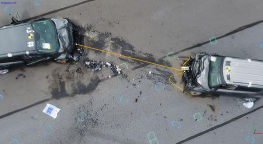
Figure 3. Photo. Example of measurements from photographs. While technology has advanced traffic crash investigation and reconstruction significantly, the emergence of unmanned aircraft systems (UAS) promises to provide another significant leap forward. Combining the well-established science of photogrammetry with aerial photography a new era of traffic crash measurement and scene documentation is taking place. Studies have demonstrated that the ability to obtain centimeter (cm) accuracy in measurements is possible with UAS.11, 12 More importantly, the use of UAS has shown significant time savings, enabling responders to clear the roadway and the scene much faster than before. Finally, the price point for entry into UAS may allow agencies to have multiple units in the field, eliminating the need to retrieve more expensive technology from a storage location or the need to respond to another officer in possession of a 3D scanner or Total Station. Unmanned Aircraft Systems for Other Traffic Incident Management-Related PurposesThe time saving advantage of using UAS for traffic crash mapping and modeling is easily understood compared to other technologies. The potential of the technology for other TIM-related purposes is less understood. Like many new tools, experimentation will likely unleash the creativity of people to solve problems in new ways. One can envision a few places where UAS might help with TIM. The following activities might be augmented by UAS:
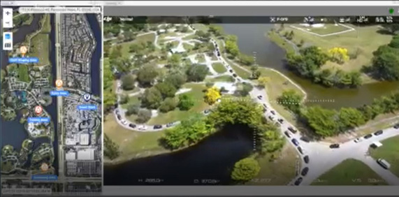
The Texas A&M Transportation Institute reviewed a number of UAS-TIM functions to demonstrate the potential for UAS to accomplish these functions.13 The research team established that UAS was capable of incident verification and monitoring traffic incidents, alternate routes, and queuing. The Florida Highway Patrol (FHP) can securely access a live video feed from an unmanned aerial vehicle (UAV) available to any authorized user via Internet Protocol (IP) address. The agency recently provided the State Emergency Operations Center with images of traffic congestion at a South Florida health testing facility. These are shown in figure 4.
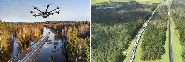
Figure 4. Screenshot. Florida Highway Patrol unmanned aerial vehicle live feed images. The North Carolina State Highway Patrol provided video images and photographs of roadway flooding during 2018 tropical storm and hurricane events. Following Hurricane Michael, the FHP flew similar missions to detect queues on Interstate 10. Examples of these images are shown in figure 5.
Figure 5. Photo. Emergency applications for unmanned aircraft systems. Two aerial photographs of highways in North Carolina taken with unmanned aircraft systems. The first shows a flying drone with a flooded, two-lane, rural highway below it. The second shows the back up on a four-lane, divided highway with bumper to bumper traffic in one direction for miles.
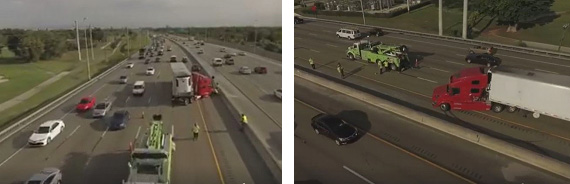
The towing and recovery industry is an important part of traffic incident management and they are beginning to use UAS for complex recovery operations at roadway incidents. There is also an opportunity for towing and recovery to use UAS to review incident scenes before they respond, ensuring that they understand the situation and bring the appropriate equipment.14 Sample images from a tow operator in Florida are shown in figure 6.
Figure 6. Photo. Roadway images to support tow operator assessment. Two aerial photographs of an accident with a tractor trailer truck on an eight-lane highway in Florida taken with unmanned aircraft systems. The images are taken from two different directions and there is a tow truck on the scene and traffic is going around the incident in the two far right lanes.
Planned special events are another application of UAS, particularly as it relates to the movement of people and vehicles. In Daytona Beach, the Police Department has acquired four UAS specifically for use in planned special events like the Daytona 500 race and “Bike Week.”15 The National TIM Responder Training Program advances the state of the practice nationally for TIM. Through mid-2020, almost 500,000 U.S. responders had been trained in one of the several delivery mechanisms for the program. The Puerto Rico Police Academy used UAS as part of their TIM training to bring a different perspective to their TIM training practicum that was held on a closed parking lot with actual response vehicles. With UAS, trainers were able to conduct live training and then bring an aerial view back into the classroom for discussion. Figure 7 is an image from the Puerto Rico TIM training.
Figure 7. Photo. Puerto Rico Traffic Incident Management training practicum with UAS. An aerial photograph of an in progress training in a parking lot. Two cars have had a head on collision and are up on the curb. Cones are set up around the accident and a strecher is ready there is a firetruck on the scene. A large group of people is standing watching at a safe distance.
11 Jurkofsky, D., “Accuracy of SUAS Photogrammetry for Use in Accident Scene Diagramming,” SAE Int. J. Trans. Safety, 3(2):2015, doi:10.4271/2015-01-1426.[Return to note 11] 12 Bullock, John L, Robert Hainje, Ayman Habib, Deborah Horton, and Darcy M. Bullock. “Public Safety Implementation of Unmanned Aircraft Systems for Photogrammetric Mapping of Crash Scenes.” Transportation Research Record: Journal of the Transportation Research Board. 2673.7 (2019): 567-574. Print. [Return to note 12] 13 Stevens, C., T. Blackstock. Demonstration of Unmanned Aircraft Systems Use for Traffic Incident Management (UAS-TIM). Texas A&M Transportation Institute. PRC 17-69F. December 2017. [Return to note 13] 14 Brown, Shelby. Drones could help during your next car breakdown. c/net. September 2019. [Return to note 14] 15 Griffin, N. Daytona Beach Police to Use Drones During Daytona 500. Spectrum News 13. February 2019. [Return to note 15] |
|
United States Department of Transportation - Federal Highway Administration |
||