Chapter 3. State of the Practice and Demonstration Site Selection
Describing the state of practice for the use of connected vehicle (CV) data in modeling of weather-responsive management strategy (WRMS) using analysis, modeling, and simulation (AMS) tools requires looking at each aspect in turn, and identifying agencies and locations in common. The analysis proceeds from the broadest to the most specific cases, starting with agencies collecting weather-related CV data. It moves to agencies using those data for WRMS, and then to online AMS model deployments, and finally to opportunities for simulation of WRMS with AMS tools using weather-related CV data.
Connected Vehicle Data Collection
CV data collection is most common with agency maintenance fleet automated vehicle location (AVL) deployments. CV data collection practices can vary in what data are collected and by what means. They minimally collect vehicle location for dispatch and shift reporting purposes. The most complete deployments may provide detailed information on vehicle location, road condition, and road treatment operation. The Wyoming Department of Transportation (WYDOT) enables its drivers to provide data on events and conditions beyond those specifically associated with winter maintenance, such as rock falls and debris on the roadway.(42) CV data systems may also be used in non-winter applications, such as herbicide application.
CV data, more specifically, has been deployed in integrated mobile observations (IMO) projects and the Wyoming connected vehicle pilot (CVP) sponsored by the U.S. Department of Transportation (USDOT). The IMO projects were developed in three phases of increasing sophistication with the Minnesota, Michigan, and Nevada departments of transportation (DOT).(43) Although the details of the objectives and deployments varied among the three, phase 1 deployments generally demonstrated AVL capabilities for staffing and reporting, followed in phase 2 by more specific weather-related data gathering for winter maintenance activities, and in phase 3 by expanded data gathering over more vehicles, data types, and communications media, including dedicated short-range communications (DSRC). The Wyoming CVP incorporated many of the IMO lessons in the development and deployment of a complete CV solution that addressed applications including spot weather warnings.(44) Information from connected snowplow trucks is blended with road weather information system (RWIS) and weather forecast information to generate alerts for travelers along the Interstate 80 (I–80) corridor through Wyoming.
Table 3 describes the state of practice of CV weather data collection among selected State and local transportation agencies. Data types included in the CV collection are all linked to the vehicle location and time at which they were observed by the vehicle’s sensor systems. The data may include observations of environmental conditions such as ambient air and pavement temperatures and relative humidity; the status of pavement treatment equipment such as the plow and material spreader; other vehicle-sourced weather-related information such as wiper status, wheel speed, and brake status; and, in some cases, camera images. Practices vary substantially among agencies.
Agencies generally get CV data from their own fleet vehicles, particularly from snowplow trucks. Data may be routed, however, through third-party data networks, particularly in the case of AVL deployments. These may be solutions operating directly through a cellular service provider, or a more customized AVL solution operating over any of the commercial cellular data networks. Alternatively, agencies may use their own data radio networks on channels typically shared with voice communications. Agencies may also collect the data over a Wi-Fi connection at their maintenance facilities at the end of a vehicle’s route. While not providing real-time data collection, this enables downloading the data for maintenance management and road condition reporting. The IMO agencies and WYDOT, as part of the CVP deployment, have demonstrated and continue to get CV road weather data through their DSRC deployments. The literature review did not find any agencies getting CV road weather data from third parties at this time.
Data originating on CVs may be processed at any of several opportunities before they become available to WRMS applications. Although no specific examples were identified in the literature survey, an AVL service provider could modify the data stream, for example, to bucket the data into uniform time intervals rather than provide precise observation times or to insert data to fill gaps. Agencies receiving the data, whether through a third party or their own network, may use intermediate or aggregated data stores to provide common access for multiple applications. Nevada DOT’s Nevada Data Exchange (NDEX) and Michigan DOT’s Data Use Analysis and Processing (DUAP) capture road weather data in this manner. In the Wyoming CVP, the weather data were extensively processed at each step of the data trail from acquisition at the vehicle to the Operational Data Environment, and on into the Pikalert system. Beyond these specific examples, the most common CV weather data processing comes in the various forms of a maintenance decision support system (MDSS), to be discussed more in the context of WRMS.
Table 3. Agency connected vehicle weather data collection state of practice.
| Agency |
Data Types |
Data Sources (maintenance vehicles [MV]) |
Communications Channel |
Processing |
| Alaska Department of Transportation and Public Facilities (DOT&PF) |
Position, time, plow up/down, material |
1,000 MV |
Cellular |
— |
| Arizona Department of Transportation (DOT) |
Position, time, speed, plow position, spreader status, spreader setting, pre-wet status, pre-wet setting, material type, distance spread, road temperature |
>75 percent of MV fleet |
Cellular |
Web-based supervisory tools |
| Maricopa County, Arizona |
Position, time, and other SAE J2735™ data, depending on application |
Anthem, Arizona, testbed for test dedicated short-range communication (DSRC) vehicles |
DSRC |
— |
| City of Bozeman, Montana |
Position, time, plow up/down |
11 MV |
Cellular |
— |
| City of Dubuque, Iowa |
Position, time, plow up/down, material, pavement temperature, air temperature |
18 MV |
Cellular |
— |
| City of Goshen, Indiana |
Position, time, plow up/down, other |
20 MV |
Radio |
— |
| Colorado DOT |
Position, time, plow up/down, material, pavement temperature, air temperature, humidity, surface friction, dashboard camera (dash cam), engine diagnostics |
1,200 heavy-fleet vehicles, 890 light vehicles |
Cellular, Wi-Fi, satellite |
Maintenance decision support system (MDSS) |
| Idaho Transportation Department |
Position, time, plow up/down, material, pavement temperature, air temperature |
236 MV |
wi-Fi |
— |
| Illinois DOT |
Position, time, plow up/down |
40 MV |
Radio |
— |
| Indiana DOT |
Position, time, pavement temperature, air temperature |
 |
Cellular |
MDSS |
| Iowa DOT |
Position, time, plow up/down, material, pavement temperature, air temperature, dash cam |
902 MV |
Cellular, Wi-Fi |
— |
| Kentucky Transportation Cabinet |
Position, time, plow up/down, material, pavement temperature, air temperature, other |
1,430 MV |
Cellular, satellite |
MDSS |
| Maine DOT |
Position, time, pavement temperature, air temperature, other |
125 |
Wi-Fi |
— |
| Michigan DOT |
Position, time, accelerometry, speed, surface temperature, air temperature, humidity/dew point, images, wheel speed, CAN bus, spray flow meter, images, engine state |
15 Integrating Mobile Observations (IMO) Ford® F150s, 340 plow trucks; VIDAS, IMO, automated vehicle location (AVL), basic safety message (BSM); 30 trucks doing herbicide application |
Cellular, Wi-Fi, DSRC |
Weather-Responsive Traveler Information System (Wx–TINFO), Data Use Analysis and Processing (DUAP), MDSS, Vehicle Data Translator (VDT), Motorist Advisories and Warnings (MAW), ArcGIS®-Collector application (app) |
| Minneapolis, Minnesota |
Position, time |
200 MV |
Cellular |
— |
| Minnesota DOT |
Position, time, air temperature, relative humidity, surface temperature, surface condition, friction, spreader control information, wiper status, brake status, dash cam images |
850 plow trucks, 25 light-duty vehicles, 35 mower tractors with AmeriTrak AVL |
Cellular, DSRC |
WebMDSS, 511 |
| Missouri DOT |
Position, time, plow up/down, material, pavement temperature, air temperature |
20 MV |
Cellular |
— |
| Montana DOT |
Position, time, plow up/down |
5 MV |
Wi-Fi |
— |
| Nebraska DOT |
Position, time, pavement temperature, air temperature, dash cam images, engine diagnostics |
675 MV |
Cellular |
MDSS |
| Nevada DOT |
Position, time, air temperature (two sensors), ambient pressure, humidity, surface temperature, spreader rate, spreader material, wiper rate |
Nine plow trucks, one service patrol |
Cellular, DSRC, radio, Wi-Fi |
Nevada Data Exchange (NDEX), Pikalert® VDT/enhanced maintenance decision support system (EMDSS)/MAW |
| New York State DOT |
Position, time |
1,600 MV |
Cellular |
— |
| North Dakota DOT |
Position, time, plow up/down, material, pavement temperature, air temperature, other |
33 MV |
Cellular |
MDSS |
| Ohio DOT |
Position, time, material, other |
170 MV |
Cellular |
— |
| Oregon DOT |
Position, time, plow up/down, material, pavement temperature |
29 MV |
Cellular |
— |
| Pennsylvania DOT |
Position, time, material, pavement temperature, air temperature |
2,250 MV |
Cellular |
MDSS |
| Rhode Island DOT |
Position, time, pavement temperature, air temperature, other |
86 MV |
Cellular |
— |
| South Dakota DOT |
Position, time, plow up/down, material, pavement temperature, air temperature, other |
125 MV |
Cellular |
MDSS |
| St. Joseph County, Indiana |
Position, time, plow up/down, material |
10 MV |
Cellular |
MDSS |
| Utah DOT |
Position, time, plow up/down, road conditions, weather conditions, other |
505 MV; also, citizen reporters using mobile app, used for 140 roadway segments |
Cellular |
— |
| Vermont DOT |
Position, time, plow up/down, material, pavement temperature, air temperature |
250 MV |
Cellular |
— |
| Virginia DOT |
Position, time |
11,000 MV |
Cellular |
MDSS |
| Washington State DOT |
Position, time, plow up/down, material, pavement temperature, air temperature |
500 MV |
Cellular, data radio |
— |
| West Des Moines, Iowa |
Position, time, plow up/down, material, friction, pavement temperature |
16 MV |
Cellular |
MDSS |
| Wisconsin DOT |
Position, time, plow up/down, material, pavement temperature, air temperature, engine diagnostics |
754 MV |
Cellular, Wi-Fi |
MDSS |
| Wyoming Department of Transportation (WYDOT) |
Road conditions, weather conditions, incidents, alerts, rock fall, location, variable speed limit (VSL) recommendations, damage report, messages |
328 plow trucks using WYDOT tablet app and CompassCom® AVL |
WyoLink (statewide digital trunked VHF P–25 radio) |
— |
| WDOT |
Position, location, BSM Part 1, weather data from WeatherCloud sensors (per Section 5.5.1 of the Wyoming Connected Vehicle [CV] Pilot Interface Control Document) |
— |
— |
Pikalert |
Connected Vehicle Data Use in Weather-Responsive Management Strategies
Most agencies using CV (AVL) data appear to be focused on non-WRMS applications. The most common use appears to be in staffing and winter maintenance reporting based on snowplow truck locations. AVL data feeds with information on plow and spreader equipment enable agencies to use the data in winter maintenance material management applications. The location data, and any additional vehicle and engine data, may be used in fleet management applications.
A significant number of agencies use the CV data with cameras in those vehicles to inform and support traveler information, 511, and plow camera websites. This use is apparently separate from but not inconsistent with the more fully developed weather-responsive traffic management strategies (WRTM).
Agencies that collect and use mobile and CV data for WRMS are a small subset of agencies that may collect and use mobile and CV data, or may have implemented similar transportation systems management and operations (TSMO) strategies based on non-weather-responsive criteria. For example, many agencies use variable message signs (VMS) for (non-weather-related) incident notification and general traveler information. A smaller subset has access to CV data and uses their VMS for specific WRMS applications. Table 4 identifies agencies that have implemented WRMS applications based on CV data.
Among the WRTM strategies, VSL corridors have been deployed in relatively few locations. VSL has been more generally used for speed harmonization and queue warning systems—for example, on Pennsylvania’s Interstate 76 (I–76) Schuylkill Expressway. Oregon DOT has deployed VSL in several locations, but the speed limits are advisory and not tied to any CV data sources. Utah DOT has deployed VSL signage on its I–80 Parley Canyon, specifically for weather-responsive strategies, but it is not tied to any CV data sources. Speed limits on this I–80 section in Utah are recommended by traffic management center (TMC) or highway patrol staff, based on measured speeds and perceived travel conditions, and are not automated. WYDOT has similarly implemented VSL on the Elk Mountain corridor on I–80 between Laramie and Rawlins. Requests for speed limit changes can be initiated by plow truck drivers, the highway patrol, or the TMC. Unlike the Utah location, the Wyoming CVP has enabled CV data from agency vehicles to be explicitly considered in monitoring for conditions meriting a reduced speed limit.
The use of VMS is widespread for relaying roadside traveler information, including weather-related messaging. It is less common to find VMS specifically associated with CV road weather data. The Wyoming CVP has generated enough experience with CV data that it is considering posting relevant messages in conjunction with its VSL postings. Michigan DOT is exploring what messages could be automated, based on which data feeds, in its TMC.
Table 4. Agency connected vehicle road weather-responsive management strategies state of practice.
| Agency |
Variable Speed Limit (VSL) Deployment Basis |
Variable Message Sign (VMS) Deployment Basis |
Plow Routing Deployment Basis |
Anti-Icing Deployment Basis |
Other |
| Alabama Department of Transportation (DOT) |
24 VSL on Interstate 10 (I–10) near Mobile, Alabama, for low-visibility and fog conditions |
— |
— |
— |
— |
| Alaska Department of Transportation and Public Facilities (DOT&PF) |
— |
— |
Routing decision |
— |
Materials management, reports, operational analysis, vehicle diagnostics |
| Arizona DOT |
— |
Dust storm warnings on I–10, not currently using connected vehicle (CV) data |
— |
— |
Risk management, performance monitoring, event reconstruction, operational analysis, materials reporting |
| City of Bozeman, Montana |
— |
— |
Routing |
— |
Materials management |
| City of Dubuque, Iowa |
— |
— |
— |
— |
Traveler info, road weather reports |
| City of Goshen, Indiana |
— |
— |
Routing |
— |
Traveler info, reports, other |
| Colorado DOT |
2018–2019 installing road weather-responsive management strategies (WRMS) VSL on Interstate 70 (I–70) Glenwood Canyon |
2018–2019 installing WRMS VMS on I–70 Glenwood Canyon |
Route planning, plow locations on website |
Maintenance decision support system (MDSS) |
Automated vehicle location (AVL) for fuel tracking, road weather info, operational analysis, vehicle diagnostics |
| Idaho Transportation Department |
— |
— |
— |
— |
Reports, materials management |
| Illinois DOT |
— |
— |
— |
— |
Reports, materials management |
| Indiana DOT |
— |
— |
— |
MDSS |
Materials management |
| Iowa DOT |
— |
— |
Route review |
— |
Traveler info, reports, materials management, operational analysis, vehicle diagnostics |
| Kentucky Transportation Cabinet (TC) |
— |
— |
Route optimization (ArcGIS®) |
MDSS |
Traveler info, reports, materials management |
| Maine DOT |
— |
— |
— |
— |
Reports |
| Michigan DOT |
— |
Exploring what messages to automate in traffic management system (TMC) |
— |
MDSS |
Herbicide application, operational analysis, vehicle diagnostics, material usage |
| Minneapolis, Minnesota |
— |
— |
Routing |
— |
Vehicle diagnostics, staffing |
| Minnesota DOT |
— |
— |
— |
Treatment recommendations through WebMDSS |
Motorist Advisories and Warnings (MAW), 511 with plow location, fleet management, vehicle maintenance, materials management |
| Missouri DOT |
— |
— |
— |
— |
Reports, materials management |
| Nebraska DOT |
— |
— |
— |
MDSS |
Material usage, operational analysis, vehicle diagnostics, road weather |
| Nevada DOT |
On U.S. Route 395 (US–395), triggered by wind gust >30 miles per hour (mph) measured by either of two environmental sensor stations (ESS) |
— |
— |
Treatment recommendations, material usage: per Federal Highway Administration (FHWA)/Nevada DOT practice guidelines |
MAW traveler info, data sharing Weather Data Environment (WxDE) |
| New York State DOT |
— |
— |
— |
— |
Staffing, vehicle diagnostics, info sharing, operational analysis |
| North Dakota DOT |
— |
— |
Routing |
MDSS |
Materials management |
| Ohio DOT |
— |
— |
Routing |
— |
Materials management |
| Oregon DOT |
Advisory speeds in several locations, primarily for advanced traffic management applications in corridors |
— |
— |
— |
Reports, traveler info, materials management |
| Pennsylvania DOT |
— |
— |
Route review |
MDSS |
Reports, material usage, operational analysis |
| Rhode Island DOT |
— |
— |
Routing |
— |
Reports materials management |
| South Dakota DOT |
— |
— |
— |
MDSS |
Traveler info, reports, materials management |
| St. Joseph County, Indiana |
— |
— |
Routing |
MDSS |
Traveler info, other |
| Utah DOT |
Interstate 80 (I–80) Parley Canyon speed limits: highway patrol or TMC recommendations based on traffic speed and road conditions |
— |
Route optimization (ArcGIS) |
— |
Traveler info for Utah DOT traffic website/application, 511, vehicle diagnostics |
| Vermont DOT |
— |
— |
Route optimization (TransCADℜ) |
— |
Traveler info, reports, materials management |
| Virginia DOT |
— |
— |
— |
MDSS |
Staffing, info sharing |
| Washington State DOT |
Snoqualmie Mountain Pass on Interstate 90 (I–90) |
Snoqualmie Mountain Pass on I–90 |
— |
— |
Reports, materials management, road weather reports, operational analysis |
| West Des Moines, Iowa |
— |
— |
Turn-by-turn real-time routing |
MDSS |
Materials management, contractor management |
Winter maintenance strategies have been more broadly deployed, primarily because of their direct association with AVL systems and with MDSS. Many agencies with AVL systems include snowplow routing among applications using that location data. It is less clear how many of those are providing real-time routing based on current vehicle location, as opposed to keeping vehicles on planned routes or planning future routes based on prior routing experience. Routing is a component of MDSS operations for some agencies, though not all.
A few agencies are using route optimization tools to improve efficiency of their plow routes. According to a 2017 Clear Roads Pooled Fund Study report,(45) tools used for this purpose include C2Logix’s FleetRoute™, Caliper® Corporation’s TransCAD, and Esri® ArcGIS. Use of these tools appears to be offline for planning purposes, and none of these tools appear to explicitly consider impacts of traffic-variable travel time on routing.
Like plow routing, anti-icing strategies can be implemented by standard agency practices based on weather forecasts, or by more interactive MDSS analyses. In either case, data from vehicles can be used alongside forecast data to focus the application timing and locations. Among agencies for which information is provided in the literature, both Nevada(46) and Minnesota(47) explicitly describe using CV data with their MDSS to support treatment decisions.
Analysis, Modeling, and Simulation Tools and Weather-Responsive Management Strategies
The purpose of this state-of-the-practice summary is to identify candidates for modeling of the use of CV data in WRMS using AMS tools. The review of AMS tools describes the basis for and application of AMS tools to assess WRMS. The review also describes several specific assessments of WRMS using those AMS tools. Among those prior analyses, there was limited experience with modeling CV in conjunction with WRMS. There were slightly more cases investigating WRMS applications, but without the CV influence. A broader pool of candidates might be drawn from the collective experience with AMS tools being applied to active traffic demand management (ATDM) and dynamic mobility applications (DMA), but many of these are in areas without significant winter weather conditions. An alternative approach would be to look at other analyses using AMS tools that could be adapted to the CV WRMS cases. The following brief descriptions identify relevant models for inclusion among candidate sites for CV WRMS analysis and deployment.
Colorado. A model of the Eisenhower-Johnson Memorial Tunnel corridor on Interstate 70 (I–70) in Colorado, built to study flow metering techniques,(48) could conceivably be repurposed to investigate CV WRMS. That corridor has been CV-enabled as part of the Colorado DOT RoadX project and could provide a robust testbed for WRMS.
Illinois. The AMS testbed for Chicago is the only known case that has integrated CV and weather into its analyses. A DYNASMART model of the Chicago area was used in both corridor and network studies to assess ATDM and DMA applications related to the impact of weather conditions, including anti-icing and snowplow routing.(3)
Kansas. A Vissim model of a 10-mile segment of Interstate 35 (I–35) in suburban Kansas City has been built and calibrated by Kansas DOT and applied to evaluate multiple operational strategies, including ramp metering. This model can be adapted to account for weather events and CV applications by utilizing driver behavioral parameters and CV Vissim packages developed by the research team.
Kansas/Missouri. A Traffic Estimation and Prediction Tools (TrEPS)/DYNASMART model of a portion of the Kansas City metropolitan area roadway network was developed as part of a Federal Highway Administration (FHWA) project investigating Integrated Modeling for Road Condition Prediction (IMRCP).(2) This online model included effects of weather conditions, incidents, and work zones, but did not explicitly model WRMS strategies to mitigate the impacts of those events.
Minnesota. An AMS model in Minneapolis using DynusT was developed for analysis of various integrated corridor management strategies, including messaging on dynamic message signs.(49) The analysis did not include any weather effects or CV data, but did offer a case of another AMS tool being used in a weather-affected location, with potential for repurposing of that model. Additionally, microscopic models may be available upon request from the Minnesota DOT and University of Minnesota.
Utah. A TrEPS/DYNASMART model of the Salt Lake City network was built to assess “demand management, variable speed limit, VMS, and weather-responsive incident management using VMS.”(50) An arterial corridor extract of that TrEPS model of Salt Lake City was used to investigate weather-responsive traffic signal operations.(1) Neither analysis addressed the use of CV data in traffic or weather data gathering.
Wyoming. A significant section of I–80 in Wyoming has been modeled in Vissim for a safety performance evaluation as part of the WYDOT CVP.(51) The model has already had significant calibrations and is intended for further analysis in later phases of the CVP.
Site Analysis and Selection
Site recommendations for assessing the benefits of applying AMS tools to WRMS using CV data depend on availability of CV data, WRMS in use, and calibrated AMS tools for those sites. Recognizing there is no perfect fit, recommendations aim to balance technological fit of data and systems with the resources required to deploy the models and availability of agencies to assist in development and implement the results.
Agencies and sites to be considered must be currently implementing WRMS. The implementation need not be longstanding or fully mature, but committed to development and deployment in its operations. Priority is given to sites looking to expand deployments of WRMS to new operational contexts, whether geographical, modal, or technological. The area of operations has to regularly experience weather conditions such that the WRMS are valuable and provide opportunities for evaluation.
Agencies and sites to be considered must be currently collecting, or intend to collect, CV or mobile data. The data collection could be from an existing or developing AVL or CV environment. Priority is given to those currently collecting vehicle location and road weather data for use in WRMS applications.
Agencies and sites to be considered must be currently using, or interested in using, an AMS tool for evaluating their CV-enabled WRMS applications. Development of traffic models with the AMS tools requires substantial interaction with the infrastructure owner-operator to configure the network model and secure data feeds from network sensors, operations, and controls. Priority is given to agencies and models that have already demonstrated application of models for WRMS application assessment, with or without CV data.
AMS tools to be considered for use in WRMS analysis must be applicable to those particular strategies, and fully implementable on the agency’s transportation network. The number of AMS tools applicable to analysis of WRMS with CV data is constrained by the lack of support for weather input to the models, limited support for CV data integration, and scarcity of data with which to calibrate models accordingly.
Figure 1 maps the potential agency sites for applying AMS tools to CV WRMS to the key analysis needs—CV data, WRMS application, and AMS tool models. The most appropriate alternatives from that mapping are summarized in table 5. The sites selected for the application of AMS tools using CV data to simulate WRMS are in the City of Chicago and along the I–80 corridor in Wyoming.
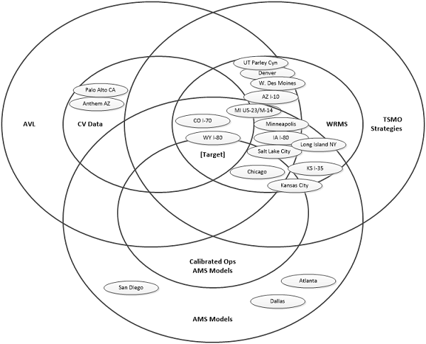
AMS = analysis, modeling, and simulation. AVL = automated vehicle location. AZ = Arizona. CA = California. CO = Colorado. CV = connected vehicle. Cyn = Canyon. I–10 = Interstate 10. I–35 = Interstate 35. I–70 = Interstate 70. I–80 = Interstate 80. IA = Iowa. KS = Kansas. M–14 = Michigan Highway 14. MI = Michigan. NY = New York. TSMO = transportation systems management and operations. US–23 = U.S. Route 23. UT = Utah. W = West. WRMS = weather-responsive management strategy. WY = Wyoming.
Source: FHWA
Figure 1. Diagram. Mapping of potential evaluation sites to selection criteria.
Table 5. Site analysis summary.
| Site |
CV Data |
AMS Tool |
WRMS |
| Agency |
Probes |
Network |
Corridor |
Anti-Icing |
Plow Routing |
VSL |
VMS (TI) |
| Chicago |
✓ |
— |
✓ |
✓ |
— |
✓ |
✓ |
✓ |
| Kansas City |
? |
— |
✓ |
✓ |
— |
— |
— |
✓ |
| Salt Lake City |
✓ |
— |
✓ |
✓ |
✓ |
✓ |
✓ |
✓ |
| Minneapolis |
✓ |
— |
— |
✓ |
✓ |
✓ |
— |
✓ |
| I–80, Wyoming |
✓ |
✓ |
— |
✓ |
✓ |
— |
✓ |
✓ |
| I–70, Colorado |
✓ |
— |
— |
✓ |
✓ |
✓ |
✓ |
✓ |
| I–35, Kansas |
— |
— |
— |
✓ |
— |
— |
— |
✓ |
|