Research, Development, and Application of Methods to Update Freight Analysis Framework Out-of-Scope Commodity Flow Data and Truck Payload Factors
Chapter 7. Farm-Based Shipments of Chickens
Methodological Approach
The process for modeling chicken farm-based commodity flows is divided into two separate sub-processes—one for broilers and another for pullets. Broilers are raised for consumption while pullets are raised for breeding. After broilers are hatched in a hatchery, they are transported to broiler farms (where they continue to grow and develop) and then to processing facilities where they become an in-scope commodity. Similarly, after pullets are hatched they are then transported to either breeder farms (where they lay eggs that will eventually become broilers) or pullet breeder farms (where they lay eggs that will eventually become pullets). The sections that follow describe the data and the assumptions used to model this out-of-scope (OOS) commodity.
Broilers
The process for modeling OOS broiler farm-based commodity flows is based on the portion of the supply chain that constitutes the out-of-scope movement. Unlike other farm-based commodities examined as part of this study, broilers are assumed to feature two out-of-scope movements that must be captured: hatchery-to-farm and farm-to-processing. Once broilers reach a processing facility, it then becomes an in-scope commodity movement that is captured by the Commodity Flow Survey.
The process uses the following data sources:
- United States Department of Agriculture (USDA) National Agricultural Statistics Service—The USDA National Agricultural Statistics Service (NASS) provides county-level data on the amount of poultry hatched (measured in head) and state-level data on the number of broilers hatched (measured in chicks), and county-level data on the number of broilers inventoried.
- Poultry Processing Location Data—Data on the locations and sizes of poultry processing plants at the county level. Poultry processing plants are included under North American Industry Classification System (NAICS) 311615. The U.S. Census Bureau's County Business Patterns database is used as the source of this information.
Key methodological steps for hatchery-to-farm OOS movements are depicted in figure 37 and are described below:
- Estimate County Level Broiler Production (Chicks Hatched)—While data from USDA indicates the amount of poultry (i.e., chickens, turkeys, quails, etc.) hatched by county, it does not release that information for chicken broilers specifically at the county level. Instead, USDA publishes the number of chicken broilers hatched at the state level for the largest producing states. In this first step the methodology assumes that the share of broilers hatched by county is equal to the share of all poultry hatched by county. Furthermore, the number of broilers hatched is measured in chicks. In order to convert county level broiler productions to weight, the methodology assumes that a hatched broiler weighs approximately 0.25 pounds.
- Estimate County Level Broiler Attractions—Using USDA NASS data on county-level inventories of broilers, the number of hatched broilers attracted by county is estimated. With this step, the methodology is assuming that counties with inventories of broilers represent the locations of broiler farms. Though there is a NAICS code for establishments primarily engaged in raising broilers and other meat type chickens, this information is not publicly released due to privacy concerns. The analysis assumes that the number of broilers attracted to a county is proportional to its inventory. At this step in the process, production-consumption zones are defined which determine the physical extents that chicks may travel as shown in table 17.
- Distribute Broilers Between Counties—Farm-based broiler commodity flows were then distributed to counties based on their share of broiler inventories and the travel time factor between counties,
 in figure 35. Network distances between origin and destination counties were obtained from the Oak Ridge National Laboratory's County Distance Database. An iterative proportional fitting routine was run until the productions and attractions converge. in figure 35. Network distances between origin and destination counties were obtained from the Oak Ridge National Laboratory's County Distance Database. An iterative proportional fitting routine was run until the productions and attractions converge.
- Aggregate to the Freight Analysis Framework Version 4 (FAF4) Zone Level—After distribution, the county-level productions and attractions were aggregated to the FAF4 zone level.
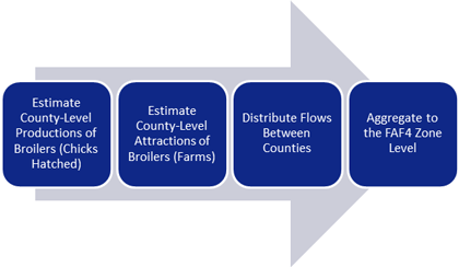 The four levels of the framework are estimating county-level productions, estimating county-level attractions, distributing flows between counties, and finally aggregating this to the FAF4 zone levels.
Figure 42. Flow chart. Framework for out-of-scope farm-based shipments of broilers—hatchery to farm.
(Source: Federal Highway Administration.)
The four levels of the framework are estimating county-level productions, estimating county-level attractions, distributing flows between counties, and finally aggregating this to the FAF4 zone levels.
Figure 42. Flow chart. Framework for out-of-scope farm-based shipments of broilers—hatchery to farm.
(Source: Federal Highway Administration.)
Table 17. States by zone for chickens.
| Zone |
States |
| Northeast |
- Connecticut.
- Delaware.
- District of Columbia.
- Maine.
- Maryland.
- Massachusetts.
- New Hampshire.
- New Jersey.
- New York.
- Ohio.
- Pennsylvania.
- Rhode Island.
- Vermont.
- West Virginia.
|
| Southeast |
- Alabama.
- Florida.
- Georgia.
- Kentucky.
- North Carolina.
- South Carolina.
- Tennessee.
- Virginia.
|
| South Central |
- Arkansas.
- Louisiana.
- Mississippi.
- Oklahoma.
- Texas.
|
| Great Plains |
- Kansas.
- Nebraska.
- North Dakota.
- South Dakota.
|
| North Central |
- Illinois.
- Indiana.
- Iowa.
- Michigan.
- Missouri.
- Minnesota.
- Wisconsin.
|
| Intermountain |
- Arizona.
- Idaho.
- Nevada.
- New Mexico.
- Utah.
- Montana.
- Wyoming.
|
| California |
|
| Pacific Northwest |
|
(Source: Federal Highway Administration.)
Key methodological steps for farm-to-processing OOS movements are depicted in figure 37 and are described below:
- Estimate County Level Broiler Production—For this movement, the number of broilers produced at the county level is estimated directly from the number of broilers attracted at the county level for hatchery-to-farm movements. Importantly, it is assumed that broilers increase in weight while awaiting processing. Broilers are assumed to increase in weight from an average of 0.25 pounds to 6 pounds before being shipped for processing.59
- Estimate County Level Broiler Attractions—Using U.S. Census Bureau County Business Pattern (CBP) data, the number of poultry processing establishments in each county was counted and its share of all establishments was calculated. Then, the same was done for each county using payroll data from the U.S. Census Bureau CBP. In this sense, payroll data served as a proxy for processing facility capacity. The share of poultry processing facilities and payroll for each county were then added and normalized so that the total sums to 100 percent. The combined shares were then rebalanced so that the when summed the county level attractions equal the total share of broilers produced in each production-consumption zone. In this manner, the poultry processing facility capacity of each county was estimated and accounted for in the methodological approach.
- Distribute Broilers Between Counties—Farm-based broiler commodity flows were then distributed to each county based on poultry processing facility capacity proxy and the travel time factor between counties. Great Circle distances between origin and destination counties were obtained from the National Bureau of Economic Research's County Distance Database. An iterative proportional fitting routine was run until the productions and attractions converge.
- Aggregate to the FAF4 Zone Level—After distribution, the county-level productions and attractions were aggregated to the FAF4 zone level.
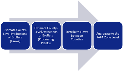 The four levels of the framework are estimating county-level productions, estimating county-level attractions, distributing flows between counties, and finally aggregating this to the Freight Analysis Framework Version 4 (FAF4) zone levels.
Figure 43. Flow chart. Framework for out-of-scope farm-based shipments of broilers—farm to processing.
(Source: Federal Highway Administration.)
The four levels of the framework are estimating county-level productions, estimating county-level attractions, distributing flows between counties, and finally aggregating this to the Freight Analysis Framework Version 4 (FAF4) zone levels.
Figure 43. Flow chart. Framework for out-of-scope farm-based shipments of broilers—farm to processing.
(Source: Federal Highway Administration.)
Pullets
The process for modeling OOS pullet farm-based commodity flows is based on the portion of the supply chain that constitutes the out-of-scope movement. For pullets, the approach captures only the hatchery-to-farm movement though it is possible that pullets may also be subject to farm-to-farm movements. These farm-to-farm movements would not be captured in the Commodity Flow Survey, but eventually pullets are sent to a processing facility where it then becomes an in-scope commodity movement.
The process uses the following data sources:
- USDA National Agricultural Statistics Service—The USDA NASS provides county-level data on the amount of poultry hatched (measured in head) and state-level data on the number of broilers hatched (measured in chicks), and county-level data on the number of pullets sold (measured in head).
Key methodological steps for hatchery-to-farm OOS movements of pullets are depicted in figure 44 and are described below:
- Estimate County Level Pullet Production (Chicks Hatched)—As previously discussed for OOS movements of broilers, data from the USDA indicates the amount of poultry hatched by county but not for pullets specifically at the county or state levels. In this first step, the methodology assumes that counties hatch broilers and pullets at the same rate as they produced all other poultry. Additionally, the methodology assumes that the production-consumption zones for both broilers and pullets are the same.
- Estimate County Level Pullet Attractions—Using USDA NASS data on county-level sales of pullets (i.e., "Chickens, Pullets, Replacement – Sales Measured in Head"), the number of hatched pullets attracted by county is estimated.
- Distribute Pullets Between Counties—Farm-based broiler commodity flows were then distributed to counties based on their share of broiler inventories and the travel time factor between counties, in figure 35. Network distances between origin and destination counties were obtained from the Oak Ridge National Laboratory's County Distance Database. An iterative proportional fitting routine was run until the productions and attractions converge.
- Aggregate to the FAF4 Zone Level—After distribution, the county-level productions and attractions were aggregated to the FAF4 zone level.
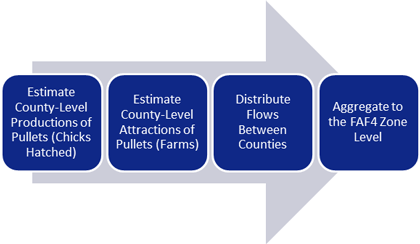 The four levels of the framework are estimating county-level productions, estimating county-level attractions, distributing flows between counties, and finally aggregating this to the Freight Analysis Framework Version 4 (FAF4) zone levels.
Figure 44. Flow chart. Framework for out-of-scope farm-based shipments of pullets—hatchery to farm.
(Source: Federal Highway Administration.)
The four levels of the framework are estimating county-level productions, estimating county-level attractions, distributing flows between counties, and finally aggregating this to the Freight Analysis Framework Version 4 (FAF4) zone levels.
Figure 44. Flow chart. Framework for out-of-scope farm-based shipments of pullets—hatchery to farm.
(Source: Federal Highway Administration.)
Results
Broilers
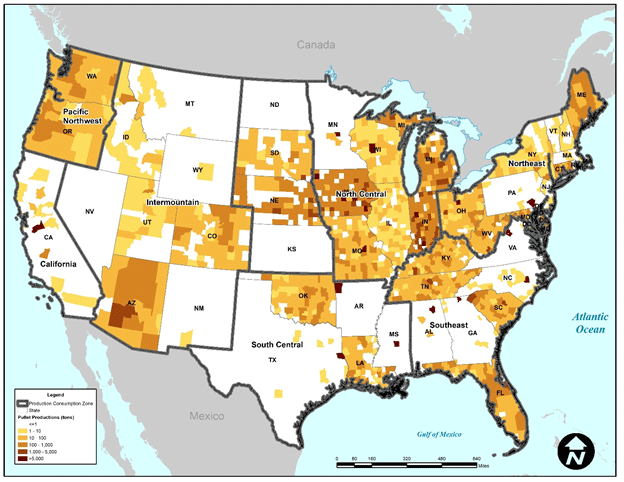
Figure 45 depicts the production-consumption zones for farm-based shipments of broilers which include for the contiguous U.S.: Northeast, North Central, Southeast, South Central, Intermountain, California, and Pacific Northwest. In keeping with the observation that farm-based shipments are primarily local, the methodology assumes that OOS movements of broilers are distributed within these zones. Also depicted in figure 45 are the results of estimated broiler production, in terms of tons of chicks hatched, at the county level. In total, over 1.2 million tons of broilers are estimated to have been produced (i.e., hatched) in 2017. Of that total, the Southeast region produced the most at 48 percent, followed by the South Central region at 31 percent, and the Northeast at 8 percent. While these data are reported at the state level, they are not reported at the county level which is the basis for the analysis methodology. In order to estimate the number of broilers hatched at the county level, the analysis assumes that counties hatch broilers in proportion to the amount of all poultry hatched.
As shown in table 18, nearly 56 percent of all broilers were hatched in the states of Georgia, Alabama, Arkansas, North Carolina, and Mississippi based on data from the USDA Chicken and Eggs Report. For hatchery-to-farm movements, the analysis assumes that broilers are transported from counties in which they are hatched to counties in which they are inventoried (i.e., "Chickens, Broilers—Inventory" in the USDA NASS database). It further assumes that the number of broilers attracted to a county is proportional to its inventory. As depicted in figure 46, these flows are broadly distributed across the Southeast and South Central zones.
Table 18. Broilers hatched in 2017.
| State |
Chicks (1,000 chicks) |
Percent of Total |
| Georgia |
1,487,111 |
15% |
| Alabama |
1,286,677 |
13% |
| Arkansas |
1,009,286 |
10% |
| North Carolina |
943,885 |
10% |
| Mississippi |
786,808 |
8% |
| Texas |
694,855 |
7% |
| Missouri |
357,703 |
4% |
| Maryland |
353,891 |
4% |
| Oklahoma |
321,195 |
3% |
| Kentucky |
321,034 |
3% |
| Virginia |
281,827 |
3% |
| South Carolina |
240,727 |
3% |
| Delaware |
210,622 |
2% |
| Pennsylvania |
207,034 |
2% |
| Louisiana |
152,788 |
2% |
| Florida |
50,268 |
1% |
| California, Tennessee, & West Virginia |
513,927 |
5% |
| Other States |
392,946 |
4% |
| Total |
9,612,584 |
100% |
(Source: USDA, Chicken and Eggs Report, 2/28/2017–1/23/2018.)
As an example, table 19 shows the results of the analysis of hatchery-to-farm farm-based shipments for the Remainder of Georgia FAF4 zone. In total, over 200,000 tons of broilers are estimated to have an origin or destination within this zone. The results indicate that for the Remainder of Georgia zone nearly 35 percent, or about 71,000 tons, of hatchery-to-farm farm-based shipments of broilers are internal. About 40 percent (over 78,000 tons) of flows are outbound while the remainder (about 25 percent or over 51,000 tons) is inbound.
The results in table 19 also indicate that neighboring states with significant agricultural activity are relatively large receivers of hatchery-to-farm farm-based shipments of broilers from the Remainder of Georgia zone. For example, Remainder of Alabama is estimated to receive 39 percent of outbound hatchery-to-farm flows from Remainder of Georgia. The Remainder of Alabama FAF4 zone is estimated to be a similarly large shipper of hatchery-to-farm farm-based shipments of broilers to Remainder of Georgia at 46 percent.
Figure 47 shows the distribution of tonnage by distance for hatchery-to-farm farm-based shipments of broilers in the Remainder of Georgia zone. The results indicate that about 20 percent of total tonnage travels 50 miles or less and about 63 percent travels 200 miles or less. About 95 percent of total tonnage for the Southeast zone is estimated to travel distances of 500 miles or less.
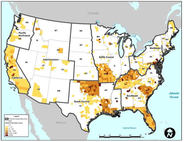 Figure 45. Map. Tons of broilers produced at the county level.
(Source: USDA NASS, 2017.)
Figure 45. Map. Tons of broilers produced at the county level.
(Source: USDA NASS, 2017.)
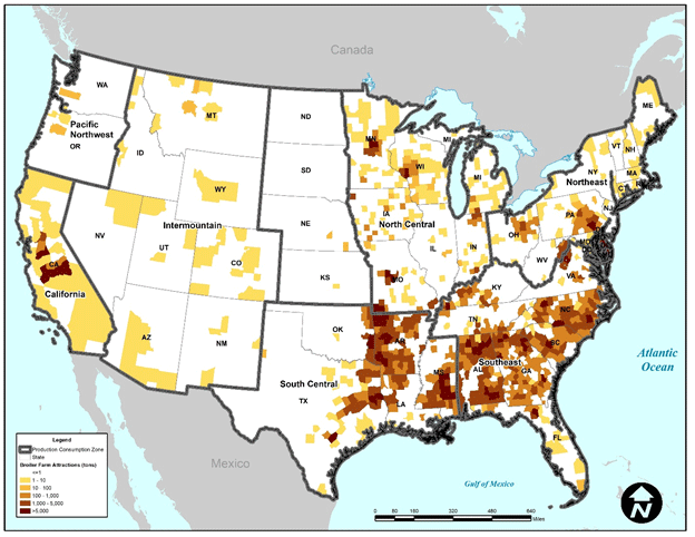 The highest broiler attraction rates are those in the Southeast (e.g., Georgia, South Carolina, North Carolina, Arkansas) with many counties in that area attracting over 5 thousand tons of broilers.
Figure 46. Map. Tons of broilers attracted at the county level for hatchery-to-farm movements.
(Source: USDA NASS, 2017.)
The highest broiler attraction rates are those in the Southeast (e.g., Georgia, South Carolina, North Carolina, Arkansas) with many counties in that area attracting over 5 thousand tons of broilers.
Figure 46. Map. Tons of broilers attracted at the county level for hatchery-to-farm movements.
(Source: USDA NASS, 2017.)
Table 19. Hatchery-to-farm results for broilers for the remainder of Georgia freight analysis framework version 4 zone.
| FAF4 Zone |
Outbound from Remainder of Georgia—Tons |
Outbound from Remainder of Georgia—Percent of Total |
Inbound to Remainder of Georgia—Tons |
Inbound to Remainder of Georgia—Percent of Total |
| Remainder of Alabama |
30,517 |
39% |
23,307 |
46% |
| Mobile-Daphne-Fairhope, AL Commodity Flow Survey (CFS) Area |
602 |
1% |
<1 |
<1% |
| Birmingham-Hoover-Talladega, AL CFS Area |
3,190 |
4% |
47 |
<1% |
| Remainder of Florida |
2,681 |
3% |
756 |
1% |
| Jacksonville-St. Mary's-Palatka, FL-GA CFS Area (FL Part) |
<1 |
<1% |
247 |
<1% |
| Miami-Fort Lauderdale-Port St. Lucie, FL CFS Area |
2 |
<1% |
244 |
<1% |
| Orlando-Deltona-Daytona Beach, FL CFS Area |
1 |
<1% |
685 |
1% |
| Tampa-St. Petersburg-Clearwater, FL CFS Area |
<1 |
<1% |
328 |
1% |
| Atlanta-Athens-Clarke County-Sandy Springs, GA CFS Area |
36,221 |
46% |
13 |
<1% |
| Savannah-Hinesville-Statesboro, GA CFS Area |
218 |
<1% |
13 |
<1% |
| Remainder of Kentucky |
4,829 |
6% |
3,309 |
6% |
| Cincinnati-Wilmington-Maysville,OH-KY-IN CFS Area (KY Part) |
<1 |
<1% |
392 |
1% |
| Louisville/Jefferson County-Elizabethtown-Madison, KY-IN CFS Area (KY Part) |
38 |
<1% |
555 |
1% |
| Greensboro-Winston-Salem-High Point, NC CFS Area |
– |
0% |
1 |
<1% |
| Remainder of North Carolina |
– |
0% |
11,792 |
23% |
| Charlotte-Concord, NC-SC CFS Area (NC Part) |
– |
0% |
2 |
<1% |
| Raleigh-Durham-Chapel Hill, NC CFS Area |
– |
0% |
3 |
<1% |
| Greenville-Spartanburg-Anderson, SC CFS Area |
– |
0% |
4,085 |
8% |
| Remainder of South Carolina |
– |
0% |
2,744 |
5% |
| Charleston-North Charleston-Summerville, SC CFS Area |
– |
0% |
167 |
<1% |
| Knoxville-Morristown-Sevierville, TN CFS Area |
– |
0% |
21 |
<1% |
| Nashville-Davidson-Murfreesboro, TN CFS Area |
– |
0% |
30 |
<1% |
| Remainder of Tennessee |
– |
0% |
56 |
<1% |
| Memphis, TN-MS-AR CFS Area (TN Part) |
– |
0% |
2 |
<1% |
| Remainder of Virginia |
– |
0% |
2,410 |
5% |
| Richmond, VA CFS Area |
– |
0% |
<1 |
<1% |
| Washington-Arlington-Alexandria, DC-VA-MD-WV CFS Area (VA Part) |
– |
0% |
1 |
<1% |
Virginia Beach-Norfolk, VA-NC CFS Area
(VA Part) |
– |
0% |
<1 |
<1% |
| Total |
78,301 |
100% |
51,211 |
100% |
(Source: Federal Highway Administration.)
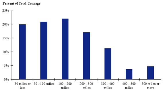 This graph is based on data only from the "Rest of Georgia" Freight Analysis Framework Version 4 (FAF4) zone. Shipments of 100-200 miles make up the largest share while shipments over 500 miles make up the smallest share.
Figure 47. Bar chart. Distribution of shipment distances for hatchery-to-farm farm-based shipments of broilers for the remainder of Georgia freight analysis framework version 4 zone.
(Source: Federal Highway Administration.)
This graph is based on data only from the "Rest of Georgia" Freight Analysis Framework Version 4 (FAF4) zone. Shipments of 100-200 miles make up the largest share while shipments over 500 miles make up the smallest share.
Figure 47. Bar chart. Distribution of shipment distances for hatchery-to-farm farm-based shipments of broilers for the remainder of Georgia freight analysis framework version 4 zone.
(Source: Federal Highway Administration.)
The estimation of farm-to-processing farm-based flows of broilers yielded results similar to hatchery-to-farm movements. In general, counties with higher numbers of poultry processing plants (NAICS 311615) as indicated by U.S. Census Bureau County Business Pattern data attract higher amounts of farm-to-processing farm-based shipments of broilers than others. As depicted in figure 48, poultry processing plants (and thus farm-to-processing flows) are concentrated in relatively few counties. Furthermore, these facilities also appear to be concentrated in FAF4 zones containing metropolitan regions as opposed to rural areas.
Table 20 shows the results of the analysis farm-to-processing farm-based shipments for the Remainder of Georgia FAF4 zone. In total, nearly 2.8 million tons of broilers are estimated to have an origin or destination within this zone. The reason for the growth in tonnage in between hatchery-to-farm and farm-to-processing movements is that broilers are assumed to increase in weight between these movements. The results indicate that for the Remainder of Georgia zone nearly 15 percent, or over 408,000 tons, of farm-to-processing farm-based shipments of broilers are internal. About 79 percent (over 2.1 million tons) of flows are outbound while the remainder (about 5 percent or over 153,000 tons) is inbound.
The results in table 20 also indicate that neighboring states with significant agricultural activity are relatively large receivers of hatchery-to-farm farm-based shipments of broilers from the Remainder of Georgia zone. For example, Remainder of Alabama is estimated to receive and ship 23 and 35 percent of farm-to-processing flows of broilers to and from Remainder of Georgia, respectively. Nearly three-quarters (or 74 percent) of outbound broiler shipments are estimated to be destined for the Atlanta-Athens-Clarke County-Sandy Springs, GA CFS Area FAF4 zone which is estimated to contain a significant amount of poultry processing capacity in the Gainesville, GA area.
Figure 49 shows the distribution of tonnage by distance for farm-to-processing farm-based shipments of broilers in the Southeast production-consumption zone. The results indicate that about 33 percent of total tonnage travels 50 miles or less and about 68 percent travels 200 miles or less. About 96 percent of total tonnage for the Southeast zone is estimated to travel distances of 500 miles or less.
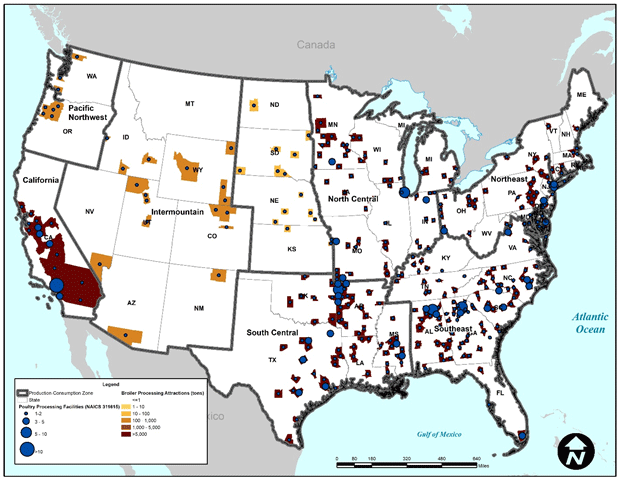 Figure 48. Map. Tons of broilers attracted at the county level for farm-to-processing movements.
(Source: USDA NASS, 2017; U.S. Census Bureau County Business Patterns, 2016.)
Figure 48. Map. Tons of broilers attracted at the county level for farm-to-processing movements.
(Source: USDA NASS, 2017; U.S. Census Bureau County Business Patterns, 2016.)
Table 20. Farm-to-processing results for the remainder of Georgia freight analysis framework version 4 zone.
| FAF4 Zone |
Outbound from Remainder of Georgia—Tons |
Outbound from Remainder of Georgia—Percent of Total |
Inbound to Remainder of Georgia—Tons |
Inbound to Remainder of Georgia—Percent of Total |
| Remainder of Alabama |
510,133 |
23% |
53,047 |
35% |
| Mobile-Daphne-Fairhope, AL |
– |
0% |
818 |
1% |
| Birmingham-Hoover-Talladega, AL |
9,567 |
<1% |
1,934 |
1% |
| Remainder of Florida |
6,452 |
<1% |
11,465 |
7% |
| Jacksonville-St. Mary's-Palatka, FL-GA (FL Part) |
– |
0% |
2 |
0% |
| Miami-Fort Lauderdale-Port St. Lucie |
40,758 |
2% |
1 |
<1% |
| Orlando-Deltona-Daytona Beach, FL |
– |
0% |
4 |
<1% |
| Tampa-St. Petersburg-Clearwater, FL |
12,612 |
1% |
1 |
<1% |
| Atlanta-Athens-Clarke County-Sandy Springs, GA |
1,633,467 |
74% |
30,060 |
20% |
| Savannah-Hinesville-Statesboro, GA |
– |
0% |
2,621 |
2% |
| Remainder of Kentucky |
3,921 |
<1% |
4,317 |
3% |
| Cincinnati-Wilmington-Maysville, OH-KY-IN (KY Part) |
– |
0% |
3 |
<1% |
| Louisville/Jefferson County-Elizabethtown-Madison, KY-IN (KY Part) |
– |
0% |
76 |
<1% |
| Greensboro-Winston-Salem-High Point, NC |
– |
0% |
2,258 |
1% |
| Remainder of North Carolina |
– |
0% |
16,767 |
11% |
| Charlotte-Concord, NC-SC (NC Part) |
– |
0% |
2,387 |
2% |
| Raleigh-Durham-Chapel Hill, NC |
– |
0% |
1,571 |
1% |
| Greenville-Spartanburg-Anderson, SC |
– |
0% |
7,519 |
5% |
| Remainder of South Carolina |
– |
0% |
13,873 |
9% |
| Charleston-North Charleston-Summerville, SC |
– |
0% |
450 |
<1% |
| Knoxville-Morristown-Sevierville, TN |
– |
0% |
183 |
<1% |
| Nashville-Davidson-Murfreesboro, TN |
– |
0% |
300 |
<1% |
| Remainder of Tennessee |
– |
0% |
3,278 |
2% |
| Memphis, TN-MS-AR (TN Part) |
– |
0% |
<1 |
<1% |
| Remainder of Virginia |
– |
0% |
393 |
<1% |
| Richmond, VA |
– |
0% |
103 |
<1% |
| Washington-Arlington-Alexandria, DC-VA-MD-WV (VA Part) |
– |
0% |
<1 |
<1% |
| Virginia Beach-Norfolk, VA-NC (VA Part) |
– |
0% |
25 |
<1% |
| Total |
2,216,910 |
100% |
153,457 |
100% |
(Source: Federal Highway Administration.)
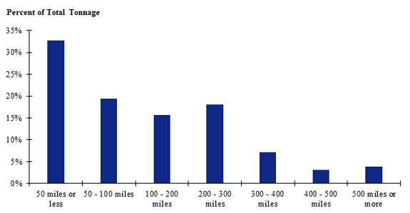 This graph is based on data only from the Southeast production-consumption zone. Shipments of 50 miles or less make up the largest share while shipments between 400 and 500 miles make up the smallest share.
Figure 49. Bar chart. Distribution of shipment distances for farm-to-processing farm-based shipments of broilers for the Southeast production-consumption zone.
(Source: Federal Highway Administration.)
This graph is based on data only from the Southeast production-consumption zone. Shipments of 50 miles or less make up the largest share while shipments between 400 and 500 miles make up the smallest share.
Figure 49. Bar chart. Distribution of shipment distances for farm-to-processing farm-based shipments of broilers for the Southeast production-consumption zone.
(Source: Federal Highway Administration.)
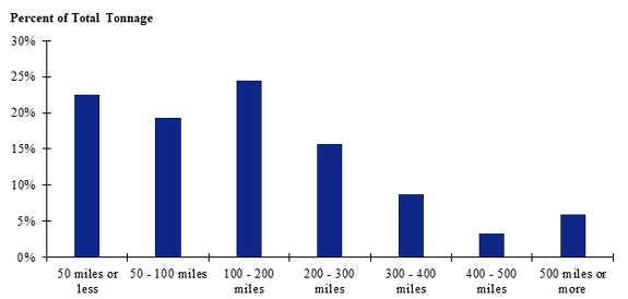
Figure 50 and figure 51 contain the trip length distributions for all hatchery-to-farm and farm-to-processing farm-based shipments of broilers in the contiguous U.S. For hatchery-to-farm farm-based shipments of broilers, the results in figure 50 indicate that about 20 percent of total tonnage travels 50 miles or less and about 66 percent travels 200 miles or less. About 95 percent of total tonnage for the Southeast zone is estimated to travel distances of 500 miles or less. The results for farm-to-processing farm-based shipments of broilers (see figure 51) is similar with 33 percent traveling 50 miles or less, 67 percent traveling 200 miles or less, and about 96 percent traveling 500 miles or less.
 This graph is based on data from the entire contiguous United States. Shipments of 50 miles or less make up the largest share while shipments between 400 and 500 miles make up the smallest share.
Figure 50. Bar chart. Distribution of shipment distances for all hatchery-to-farm farm-based shipments of broilers in the contiguous U.S.
(Source: Federal Highway Administration.)
This graph is based on data from the entire contiguous United States. Shipments of 50 miles or less make up the largest share while shipments between 400 and 500 miles make up the smallest share.
Figure 50. Bar chart. Distribution of shipment distances for all hatchery-to-farm farm-based shipments of broilers in the contiguous U.S.
(Source: Federal Highway Administration.)
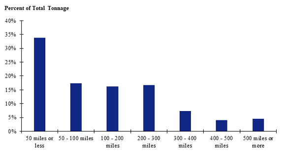 Figure 51. Bar chart. Distribution of shipment distances for all farm-to-processing farm-based shipments of broilers in the contiguous U.S.
(Source: Federal Highway Administration.)
Figure 51. Bar chart. Distribution of shipment distances for all farm-to-processing farm-based shipments of broilers in the contiguous U.S.
(Source: Federal Highway Administration.)
Pullets
The production-consumption zones for farm-based shipments of pullets, shown in figure 52, are the same as those for broilers. Also depicted in figure 52 are the results of estimated pullet production, in terms of tons of chicks hatched, at the county level. In total, over 643,000 tons of pullets are estimated to have been produced (i.e., hatched) in 2017. The estimated destinations of these productions at the county level is shown in figure 53.
Table 21 shows the results of the analysis of hatchery-to-farm farm-based shipments for the Remainder of Georgia FAF4 zone. In total, nearly 41,000 tons of pullets are estimated to have an origin or destination within this zone. The results indicate that for the Remainder of Georgia zone about 37 percent, or nearly 16,000 tons, of hatchery-to-farm farm-based shipments of pullets are internal. About 41 percent (nearly 17,000 tons) of flows are outbound while the remainder (about 21 percent or nearly 8,700 tons) is inbound.
Figure 54 shows the distribution of tonnage by distance for hatchery-to-farm farm-based shipments of pullets in the Southeast production-consumption zone. The results indicate that about 21 percent of total tonnage travels 50 miles or less and about 64 percent travels 200 miles or less. About 94 percent of total tonnage for the Southeast zone is estimated to travel distances of 500 miles or less. Similar results are shown for the contiguous U.S. in figure 55.
 The highest pullet production rates are in the Midwest (e.g., Michigan, Indiana, Ohio) with many counties in that area producing over 5 thousand tons of pullets.
Figure 52. Map. Tons of pullets produced at the county level.
(Source: USDA NASS, 2017.)
The highest pullet production rates are in the Midwest (e.g., Michigan, Indiana, Ohio) with many counties in that area producing over 5 thousand tons of pullets.
Figure 52. Map. Tons of pullets produced at the county level.
(Source: USDA NASS, 2017.)
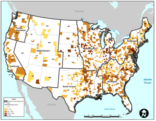 Figure 53. Map. Tons of pullets attracted at the county level for hatchery-to-farm movements.
(Source: USDA NASS, 2017.)
Figure 53. Map. Tons of pullets attracted at the county level for hatchery-to-farm movements.
(Source: USDA NASS, 2017.)
Table 21. Hatchery-to-farm results for pullets for the remainder of Georgia freight analysis framework version 4 zone.
| FAF4 Zone |
Outbound from Remainder of Georgia—Tons |
Outbound from Remainder of Georgia—Percent of Total |
Inbound to Remainder of Georgia—Tons |
Inbound to Remainder of Georgia—Percent of Total |
| Remainder of Alabama |
4,394 |
26% |
578 |
7% |
| Mobile-Daphne-Fairhope, AL CFS Area |
104 |
1% |
<1 |
<1% |
| Birmingham-Hoover-Talladega, AL CFS Area |
613 |
4% |
7 |
<1% |
| Remainder of Florida |
565 |
3% |
681 |
8% |
| Jacksonville-St. Mary's-Palatka, FL-GA CFS Area (FL Part) |
559 |
3% |
108 |
1% |
| Miami-Fort Lauderdale-Port St. Lucie, FL CFS Area |
<1 |
<1% |
229 |
3% |
| Orlando-Deltona-Daytona Beach, FL CFS Area |
<1 |
<1% |
542 |
6% |
| Tampa-St. Petersburg-Clearwater, FL CFS Area |
<1 |
<1% |
305 |
4% |
| Atlanta-Athens-Clarke County-Sandy Springs, GA CFS Area |
10,144 |
60% |
2 |
<1% |
| Savannah-Hinesville-Statesboro, GA CFS Area |
114 |
1% |
2 |
0% |
| Remainder of Kentucky |
456 |
3% |
368 |
4% |
| Cincinnati-Wilmington-Maysville, OH-KY-IN CFS Area (KY Part) |
<1 |
<1% |
47 |
1% |
| Louisville/Jefferson County-Elizabethtown-Madison, KY-IN CFS Area (KY Part) |
17 |
<1% |
64 |
1% |
| Greensboro-Winston-Salem-High Point, NC CFS Area |
– |
0% |
<1 |
<1% |
| Remainder of North Carolina |
– |
0% |
3,448 |
40% |
| Charlotte-Concord, NC-SC CFS Area (NC Part) |
– |
0% |
1 |
<1% |
| Raleigh-Durham-Chapel Hill, NC CFS Area |
– |
0% |
1 |
<1% |
| Greenville-Spartanburg-Anderson, SC CFS Area |
– |
0% |
923 |
11% |
| Remainder of South Carolina |
– |
0% |
537 |
6% |
| Charleston-North Charleston-Summerville, SC CFS Area |
– |
0% |
25 |
<1% |
| Knoxville-Morristown-Sevierville, TN CFS Area |
– |
0% |
124 |
1% |
| Nashville-Davidson-Murfreesboro, TN CFS Area |
– |
0% |
129 |
1% |
| Remainder of Tennessee |
– |
0% |
286 |
3% |
| Memphis, TN-MS-AR CFS Area (TN Part) |
– |
0% |
9 |
<1% |
| Remainder of Virginia |
– |
0% |
277 |
3% |
| Richmond, VA CFS Area |
– |
0% |
<1 |
<1% |
| Washington-Arlington-Alexandria, DC-VA-MD-WV CFS Area (VA Part) |
– |
0% |
<1 |
<1% |
| Virginia Beach-Norfolk, VA-NC CFS Area (VA Part) |
– |
0% |
<1 |
<1% |
| Total |
16,966 |
100% |
8,694 |
100% |
(Source: Federal Highway Administration.)
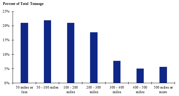 Figure 54. Bar chart. Distribution of shipment distances for all hatchery-to-farm farm-based shipments of pullets in the Southeast zone.
(Source: Federal Highway Administration.)
Figure 54. Bar chart. Distribution of shipment distances for all hatchery-to-farm farm-based shipments of pullets in the Southeast zone.
(Source: Federal Highway Administration.)
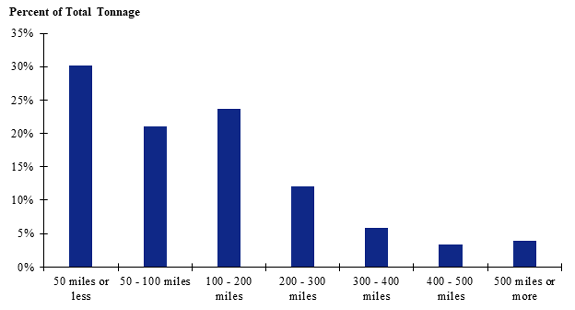 Figure 55. Bar chart. Distribution of shipment distances for all hatchery-to-farm farm-based shipments of pullets in the contiguous U.S.
(Source: Federal Highway Administration.)
Figure 55. Bar chart. Distribution of shipment distances for all hatchery-to-farm farm-based shipments of pullets in the contiguous U.S.
(Source: Federal Highway Administration.)
|