Raising Awareness of Artificial Intelligence for Transportation Systems Management and Operations
Chapter 4. Artificial Intelligence for TSMO Applications
In this chapter, you will learn that use of artificial intelligence (AI) technologies in transportation systems management and operations (TSMO) is not completely new. A handful of AI applications have been deployed at transportation management centers (TMC) in the U.S. already or are in the process of being implemented. These projects are highlighted, and lessons learned are noted, where available. From these experiences, some issues to be considered in applying AI to TSMO applications are identified and detailed in chapter 5.
This chapter provides AI examples in incident detection, ramp metering, traffic prediction, and chatbot decision support. In each section, highlights of each application include the potential or actual benefits of an AI approach over traditional methods and the agency's plan for expansion and use.
Artificial Intelligence for Incident Detection
Traditional software methods for incident detection using vehicle detectors, either via in-pavement inductive loops or shoulder-mounted radar with freeway flow models, are in declining use. Cellular phone reports and highway patrol reporting have long been shown to be more accurate and timelier than methods that rely on point detectors, particularly since point detection devices require frequent maintenance and provide noisy and missing data on traffic volume and speed. At least two examples of incident detection based on AI methods can be highlighted. Both agencies expected that use of AI methods would improve their ability to react to incidents faster by detecting them sooner and in locations where traditional detection is lacking or where traffic levels are low (e.g., rural areas with limited cellular coverage).
Nevada and Florida Departments of Transportation
Both Nevada and Florida departments of transportation (DOT) use a proprietary software as a supplement for incident detection. The AI system fuses information from a variety of sources to detect and report suspected incidents.
In addition to the traditional sources which include radar and loop detectors, the AI system processes feeds from existing Nevada DOT (NDOT) and Florida DOT (FDOT) closed-circuit television (CCTV) cameras to identify incidents using AI (neural networks). This neural network is trained to recognize scenes that are "incidents" and "not incidents," as well as "incident may be likely to occur." In both cases, the application software was deployed in areas with good existing coverage of cameras and traditional point detection. Neither agency has used traditional software incident detection methods for some time due to the unreliability of such software and since highway patrol incident warnings have tended to outperform software detection methods in recent years. Both NDOT and FDOT have reported improvements in incident detection times by the AI system of up to 12 minutes faster than other input streams and reducing crashes by 17 percent by positioning highway patrol assets accordingly and providing advanced warning of downstream congested areas on dynamic message signs.
The system is provided as cloud-hosted proprietary software that is paid for as a subscription service. Both agencies plan to continue to expand the use of the system to more freeway coverage in their existing Districts (Las Vegas and Tampa), as well as expanding the deployment to other Districts in the State, particularly to rural areas where incident reporting tends to take much longer than in urbanized areas. Both agencies began the deployment as pilot projects with the software vendor providing the software in a testing configuration. NDOT and FDOT supplied the necessary data feeds and access to configuration databases with the AI software vendor doing most of the work. Both agencies expect to expand their deployment of the system to include areas where their traditional detection infrastructure is lacking (e.g., rural areas)
Iowa Department of Transportation
Iowa DOT has partnered with Iowa State University to develop an incident detection system that relies on AI (neural networks). Similar to the goals of NDOT and FDOT, Iowa's system is focused on improving incident detection time, particularly in rural areas where camera surveillance may be available, but highway patrol notifications may take an extended period to be received. Iowa DOT has named this system Traffic Incident Management Enabled by Large-data Innovations (TIMELI).70 TIMELI uses NVIDIA Titan X graphics processing units and the open-source TensorFlow deep learning system to classify images from traffic surveillance cameras in near real time. The Iowa DOT TIMELI system monitors cameras from across the entire State and includes other data feeds such as incident reports, traffic congestion level, etc. The research project is being piloted now. According to the team, the AI technology and big data tools necessary for this size have only been available in the last three to five years. The system development and implementation were supported by a $1 million National Science Foundation grant secured by Iowa State in 2016.
In addition to the neural network incident-detection algorithms and supporting software, the TIMELI system includes information visualizations and data storage, processing, and archiving based on big data technologies, such as not only structured query language (NoSQL). The researchers have not yet to date publicly documented any quantitative improvements, but feedback from Iowa DOT TMC managers and staff has been extremely positive.71 Most of the work has been done by researchers at Iowa State University with Iowa DOT staff providing access to databases and real-time data feeds. An overview video is available on YouTube.72 Iowa DOT plans to continue expanding the use of TIMELI throughout the State.
Artificial Intelligence for Ramp Metering
Traditional methods of ramp metering typically rely on loop detectors or shoulder-mounted radar detection to determine ramp metering rates at individual ramps. A few corridor ramp metering algorithms have also been implemented by State DOTs.
Fuzzy logic and neural network methods of various flavors have been applied to ramp metering for individual ramp control,73, 74 and for corridor operations.75 Fuzzy logic has seen success in the real world, with implementations at the California DOT (Caltrans) in Northern and Southern California and Washington State DOT (WSDOT).76, 77 In these systems, individual ramps are configured with relatively simple fuzzy rules that determine to raise the metering rate when the freeway is uncongested and the ramp queue is lengthy and vice versa.
Washington State Department of Transportation
WSDOT has used fuzzy logic metering for more than 15 years. The initial implementation pilot project was led by the Washington State Transportation Center of the University of Washington in the mid-1990s. One of the benefits cited for the development of the fuzzy logic approach in the initial research was that only 5 percent of the code in the system was for the algorithm and 95 percent was for interfacing to the data inputs and providing metering outputs to the field controllers.78 WSDOT chose this fuzzy logic method primarily because previous ramp metering algorithms using heuristics and flow models at that time required substantial code for estimation of the effects of various choices of ramp metering rates, and calibration of model parameters was particularly difficult. The fuzzy logic method has since been continued to be updated as computing technology has evolved from virtual access extension computers to modern servers and databases. The Washington State deployment of fuzzy logic metering currently extends to more than 200 ramps.
Evaluation studies date back to 1999 to 2000, where University of Washington found that fuzzy logic metering provided benefits in mainline efficiency by reducing both upstream and downstream occupancy at each ramp and did a far better job than local metering at maintaining reasonable ramp queues.79
WSDOT funded the development of the fuzzy logic ramp metering software through a grant to the University of Washington. The fuzzy logic software and code is the property of WSDOT and integrated directly into the WSDOT transportation management system (TMS). All new ramp meters utilize the fuzzy logic method for ramp metering; no other methods are considered.
Caltrans
Caltrans has recently deployed fuzzy logic ramp metering on the I–80 corridor Active Traffic Management (ATM) system in Oakland, CA. The Caltrans implementation follows the logic developed and implemented by WSDOT, but not the software. Caltrans District 4 decided to use the fuzzy logic method after an analysis of competing traditional ramp metering algorithms, including system-wide automatic ramp metering (SWARM). SWARM was developed for Caltrans in the early 1990s to coordinate ramp metering actions in a corridor, but was not found to be particularly effective, mostly due to the complexity required to accurately calibrate the flow model using data from inductive loop detectors that are (or were, at the time) unreliable.80 Most ramp metering in California is currently locally traffic-responsive, using flow rates measured on the ramps and on the freeway using inductive loops, still prone to the same unreliability as the corridor-based methods such as SWARM. The use of Fuzzy logic was expected to reduce the complexity of algorithm configuration and improve the selection of appropriate ramp metering rates.
The fuzzy logic software was developed by their system provider and integrated directly into the ATM system. Costs specifically for implementation of the fuzzy logic software are not publicly available. Before and after analysis was not (or has not yet been) performed. According to the Caltrans 2017 ramp metering development plan, the fuzzy logic method is in consideration for statewide standardization, but it is not yet mandated to be used in all Districts.
Chatbots for Natural Language Question and Answering
For many years, 511 systems have used natural language processing (NLP) to understand a user's requested route. These systems historically have been limited in both their technical capability (understanding user phrases with background noise, i.e., while driving) and the phraseology expected from the user (bus stop identification numbers, freeway names and sections, etc.). Significant enhancements of NLP capabilities in digital assistants should be able to be leveraged in coming years. Metropolitan Transportation Commission (MTC) Bay Area 511 now has an Alexa skill to pass through requests for 511 information for the same phraseology that works with their interactive voice response (IVR) module.81 Alexa skills are becoming popular with cities as part of 311 and community service information systems, one of many examples in John's Creek, GA, a suburb of Atlanta.82
Recently, Virginia Department of Transportation (VDOT) held a "hackathon" with more than 50 volunteer developers to leverage the VDOT open data application programming interfaces (API) for a variety of quick demonstration projects. One of the winners ("Talk DOT") was an Alexa skill to allow users to ask questions of the VDOT database as if they were manipulating the VDOT Web interface.83 Additional functions of AI–based assistants, such as smart home technology can easily be extended to TMC operations, such as voice-activated video wall configuration and other enhancements to traditional operations.
In 2018, the City of Surprise, AZ (a suburb of the Phoenix metro area) developed a Google Assistant interface to their adaptive traffic control system. The chatbot system allows the traffic engineer to query status data using voice commands through a Google Home speaker, Google Mini, as well as Google Assistant on any phone or computer. The system is implemented using Google's DialogFlow, Actions console, Firebase, and Microsoft Azure as illustrated in figure 15 . Summary data on performance and field issues are uploaded from the adaptive system to Azure. The chatbot then is available for the user to query a data summary for the performance of an individual traffic signal or arterial for a time and date up to 1 year in the past. A "performance report" lists the Cycle time, Phase Utilization, and Arrivals on Green for a signal in a 30-minute window for a date and time. A "problems report" lists preemptions, detector failures, and communications quality for a signal or arterial.
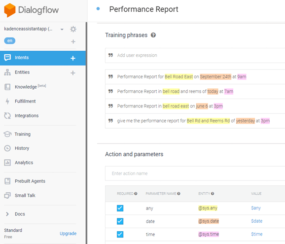
Figure 15. Screenshot. Google DialogFlow setup for the "performance report."
(Source: Federal Highway Administration.)
The technical demo (alpha software) is intended to be expanded to retrieve reports and allow the user to send commands to the system, such as to change the adaptive system optimization strategy, via voice or text when the user is not in the TMC or near a computer with the TMS software. The City contracted with their system provider to develop the software. The development cost is not available to the public. Since the City is a small agency with limited staff, the traffic engineer envisions the AI application to save time when in the field and impress visitors to the TMC with voice activated video-wall management and other automated commands.
Traffic Prediction and Traveler Information
Neural networks, fuzzy logic, and Bayesian belief networks have been applied to the problem of short-term traffic prediction on freeways and arterials.84, 85, 86, 87, 88, 89, 90 Arterials are especially challenging because they require either imputed or explicit knowledge of traffic signal timing parameters.91, 92 While most research has shown that such neural network models perform reasonably well with enough training (and accurate input data), their predictive power is typically limited to situations that were present in the training data and cannot easily be transferred to other locations and network topologies.93, 94
Delaware DOT (DelDOT) recently received a $5 million grant from the advanced transportation and congestion management technologies deployment (ATCMTD) program of United States Department of Transportation (USDOT) to develop an AI TMS as part of the Advanced Transportation and Congestion Management Technologies Deployment Program. While much of the funding will go towards upgrading infrastructure including cameras and traffic controllers, a significant portion will fund the development of AI technologies for traffic prediction, incident detection, and automated traveler information dissemination. In partnership with Federal Highway Administration (FHWA) Turner-Fairbank Highway Research Center, DelDOT has piloted several AI methods in advance of the grant award. DelDOT's process for using AI at various stages in their TMC is shown in figure 16.
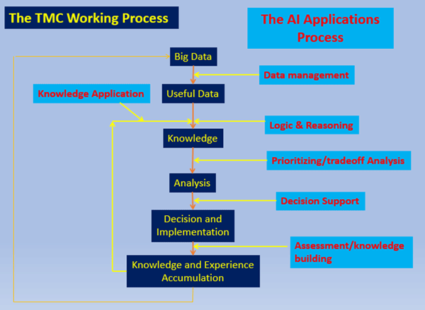
Figure 16. Chart. The Delaware Department of Transportation concept of how artificial intelligence can apply to the transportation management centers working process.
(Source: United States Department of Transportation.)
One component of the DelDOT AI strategy is to use reinforcement learning to train neural networks to manage traffic control systems as a "game" (e.g., chess) by predicting the impacts of certain traffic control actions and selecting the most effective control strategies. The pilot region/corridor where DelDOT has applied AI traffic prediction is shown in figure 17.
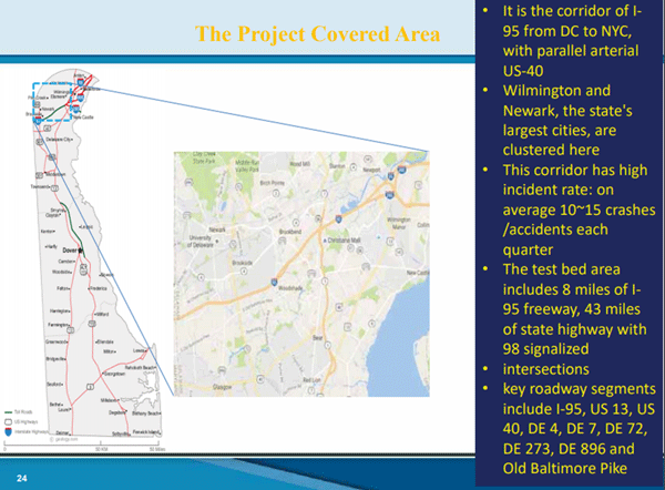
Figure 17. Photo. Network modeled by artificial intelligence in Delaware.
(Source: United States Department of Transportation.)
The pilot application of neural networks to this problem has already achieved the following objectives for assisting the TMC operators in prioritizing their workflow in the pilot corridor/region:
- Seamlessly monitoring the network situation—reducing the major workload for TMC operators.
- Alerting the operators to special situations (incidents).
- Providing information on the suspected cause of the situation and the possible prioritized options to deal with the situation.
- After the operator selects one specific option, the AI tool dynamically simulates the consequence of executing the option and predicts the time to resume normal operations and how traffic will evolve back to normal.
- Evaluating and storing the results in the knowledge base for future use.
In addition to this, the pilot deployment includes another neural network model that detects incidents based on re-identification of vehicle signatures from one set of in-pavement loops to another. This concept is illustrated in figure 18.
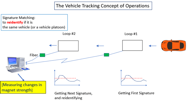
Figure 18. Diagram. Vehicle re-identification using inductive loop signatures matched by a neural network model.
(Source: United States Department of Transportation.)
Unmanned Aerial Systems Used by State Departments of Transportation
Asset management is another important element of TSMO that continues to increase in importance. Long-standing asset management practices exist for pavements, bridges, and other transportation infrastructure. Light detection and ranging (LiDAR) technology and unmanned aerial systems (UAS) photography and video feeds are now enhancing how asset management and inspections are processed. The three-dimensional (3D) point cloud data and high-resolution video generated by UASs is overwhelming in content. Machine learning tools such as neural networks and other image processing algorithms are applied to 3D point clouds to extract information and features.95
As of March 2018, 35 of 50 U.S. State DOTs have a UAS program, with 20 of the 35 using UASs for daily operations and 15 in the research phase.96 Most UASs have basic autonomous functions such as "return to base" and "hover here," but are still operated by a pilot and an observer or a pilot alone, depending on the application. UASs are most commonly used for photography, surveying, pavement inspection, daily traffic monitoring, and light pole inspections. Twenty-seven of the 35 State DOTs have added full-time staff to operate and maintain UAS fleets.
North Carolina DOT (NCDOT) and North Carolina Highway Patrol have researched the use of UASs to perform crash reconstruction data collection. In simulated testing of a staged head-on collision on a divided highway, use of three UASs reduced the time to perform the reconstruction activities from 2 hours to 30 minutes. NCDOT reported if the crash had occurred on I–95 at a busy time of day, the lost productivity impact of vehicles delayed by the lane closures would have been reduced from $12,900 to just $3,600.97
Summary of this Chapter
A variety of AI technologies have been deployed for TSMO applications. After reading this chapter, you should now be aware that several State and local DOTs have begun deploying neural network technologies for incident detection using video image analysis and traffic prediction. Fuzzy logic has been used by WSDOT for more than 20 years and Caltrans has begun deployment of fuzzy logic metering. DelDOT has piloted several AI applications for traffic congestion and incident prediction in partnership with USDOT. MTC and several other agencies have light integration of 511 with Alexa. Several arterial management agencies are piloting use of Google Assistant. More than 20 State DOTs have active UAS programs. Several DOTs are piloting use of automated vehicles for crash abatement. As AI technology continues to mature, the applications for AI in TSMO are likely to continue to expand. In the next chapter, guidelines for consideration of AI in TMCs and TMSs are provided.
You may need the Adobe® Reader® to view the PDFs on this page.
70 "AI System Helps Detect and Manage Traffic Incidents." Nvidia. Accessed December 10, 2019. [Return to footnote 70]
71 "Iowa State Engineers Dive into Big Data to Develop Better System to Manage Traffic Incidents." Iowa State University. Accessed December 10, 2019. [Return to footnote 71]
72 "Keeping Iowa Roads Safe with AI." Iowa Department of Transportation. Accessed December 10, 2019. [Return to footnote 72]
73 Sasaki, T., and T. Akiyama. Development of Fuzzy Traffic Control System on Urban Expressway. Proc., 5th IFAC/IFIP/IFORS International Conference in Transportation Systems, 1986, pp. 333–338. [Return to footnote 73]
74 Chen, L., A. May, and D. Auslander. Freeway Ramp Control Using Fuzzy Set Theory for Inexact Reasoning. Transportation Research Part A, Vol. 24, No. 1, 1990, pp. 15–25. [Return to footnote 74]
75 Sasaki, T., and T. Akiyama. Traffic Control Process of Expressway by Fuzzy Logic. Fuzzy Sets and Systems, Vol. 26, 1988, pp. 165–178. [Return to footnote 75]
76 "Ramp Metering Design Manual." Caltrans. Accessed January 24, 2020. [Return to footnote 76]
77 "Situational Awareness for Transportation Management: Automated Video Incident Detection and Other Machine Learning Technologies for the Traffic Management Center." Caltrans. Accessed January 24, 2020. [Return to footnote 77]
78 Taylor, Cynthia E. and Meldrum, Deirdre R. "On-Line Implementation of a Fuzzy Neural Ramp Metering Algorithm." Washington State Transportation Center. Accessed December 10, 2019. [Return to footnote 78]
79 Taylor, Cynthia and Meldrum, Deidre. "Evaluation of a Fuzzy Logic Ramp Metering Algorithm: A Comparative Study Among Three Ramp Metering Algorithms Used in the Greater Seattle Area." Washington State Transportation Center. Accessed December 10, 2019. [Return to footnote 79]
80 Ahn, et al. Evaluating the benefits of SWARM Strategy in Portland, OR. Proceedings of the 86th Annual meeting of the Transportation Research Board. Washington, DC. 2007. [Return to footnote 80]
81 "511 SF Bay." Metropolitan Transportation Commission. Accessed December 10, 2019. [Return to footnote 81]
82 Hutmacher, Warren. "Monthly Management Report to Elected Officials—May 2018." Johns Creek. Accessed December 10, 2019. [Return to footnote 82]
83 Chandran, Ranjani. "Talk DOT." Devpost. Accessed December 10, 2019. [Return to footnote 83]
84 See pages 38 to 41 of the 2012 TRB Circular (reference #27) for an exhaustive discussion of the short-term travel time and traffic conditions prediction problem on freeways and pages 50 to 63 for methods applied to "interrupted flow" facilities, i.e., arterials). [Return to footnote 84]
85 "Bayesian Network." Wikipedia. Accessed December 10, 2019. [Return to footnote 85]
86 Yu, B. Xiaolin, Ph.D., S., Guan, Ph.D., F., Yang, Ph.D., Z. "k-Nearest Neighbor Model for Multiple-Time-Step Prediction of Short-Term Traffic Condition." American Society of Civil Engineers Library. Accessed December 31, 2019. [Return to footnote 86]
87 Huisken, G., and A. Coffa. Short-Term Congestion Prediction: Comparing Time Series with Neural Networks. Proc., Tenth International Conference on Road Transport Information and Control, No. 472, 2000. [Return to footnote 87]
88 Huisken, G., and E. C. van Berkum. Comparative Analysis of Short-Range Travel Time Prediction Methods. Presented at 82nd Annual Meeting of the Transportation Research Board, Washington, D.C., 2003. [Return to footnote 88]
89 Park, D., L. Rilett, and G. Han. Spectral Basis Neural Networks for Real-Time Travel Time Forecasting. Journal of Transportation Engineering, Vol. 125, No. 6, 1999, pp. 515–523. [Return to footnote 89]
90 van Lint, J. W. C., S. P. Hoogendoorn, and H. J. van Zuylen. Freeway Travel Time Prediction with State–Space Neural Networks: Modeling State-Space Dynamics with Recurrent Neural Networks. In Transportation Research Record: Journal of the Transportation Research Board, No. 1811, Transportation Research Board of the National Academies, Washington, D.C., 2002, pp. 30–39. [Return to footnote 90]
91 Lin, W. H., A. Kulkarni, and P. Mirchandani. Short-Term Arterial Travel Time Prediction for Advanced Traveler Information Systems. Journal of Intelligent Transportation Systems: Technology, Planning, and Operations, Vol. 8, No. 3, 2004, pp. 143–154. [Return to footnote 91]
92 Liu, H., H. J. van Zuylen, H. van Lint, and M. Salomons. Predicting Urban Arterial Travel Time with State–Space Neural Networks and Kalman Filters. In Transportation Research Record: Journal of the Transportation Research Board, No. 1968, Transportation Research Board of the National Academies, Washington, D.C., 2006, pp. 99–108. [Return to footnote 92]
93 Chen, H., and S. Grant-Muller. Use of Sequential Learning for Short-Term Traffic Flow Forecasting. Transportation Research Part C, Vol. 9, 2001, pp. 319–336. [Return to footnote 93]
94 Ishak, S., and C. Alecsandru. Optimizing Traffic Prediction Performance of Neural Networks Under Various Topological, Input, and Traffic Condition Settings. Journal of Transportation Engineering, Vol. 130, No. 4, 2004, pp. 452–465. [Return to footnote 94]
95 Balali, V., Jahangiri, A., Machiani, S. G., "Multi-class U.S. Traffic Signed 3D Recognition and Localization via Image-based Point Cloud Model Using Color Candidate Extraction and Texture-based Recognition." Advanced Engineering Informatics, Volume 32 (April 2017). Accessed December 10, 2019. [Return to footnote 95]
96 "35 State DOTs are Deploying Drones." Civil and Structural Engineer Media. Accessed December 10, 2019. [Return to footnote 96]
97 "35 State DOTs are Deploying Drones." Civil and Structural Engineer Media. Accessed December 10, 2019. [Return to footnote 97]