United States - European Commission Urban Freight Twinning Initiative: Compendium of Project Summaries, Volume II
Overview of 2018-2019 International Urban Freight Roundtables
| Metro Plans | Pilot | United States |
Urban Goods Delivery System
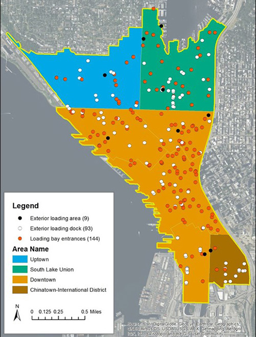
To document the comprehensive truck load/unload space network in dense cities, the Urban Freight Lab (UFL) created and conducted a cost-effective method to geospatial-map all private truck load/unload bays and docks in Seattle's Center City area. The UFL developed the methodology and the loading bay dock typology; built a user-friendly app to collect data in the field; and delivered metadata, GIS data files, and documentation of truck-related features of the loading bays and docks to the Seattle Department of Transportation (SDOT). This project is important as there is a high demand for scarce road, curb, and sidewalk space in urban areas with multiple competing uses. Without proven new tools, Seattle and other rapidly growing cities lack a data-driven way to balance limiting and/or reducing parking and loading in street space that is needed for movement of transit, cars, bikes, and trucks. There is a lack of data and information about major cities joining with the private sector to use technology and process improvement tools to purposefully manage both public and private operations of the final 50 feet space.

Private freight bays and loading dock in Seattle's Downtown, Uptown, and South Lake Union urban centers.
Source: Urban Freight Lab University of Washington.
Project Types
Metropolitan Plan, Pilot.
Period of Performance
September 2016 - June 2017.
Project Site
Seattle, Washington, USA.
Contact
Barb Ivanov
Director, Urban Freight Lab
SCTL Center, University of Washington
Seattle, WA, USA
IvanovB@uw.edu
Topics Addressed
- Building/road design.
- Curbside delivery and parking.
- Economic competitiveness.
- Last mile delivery.
- Livability/quality of life.
- Mobility/congestion.
Key Outcomes
- Eighty-seven percent of buildings in Seattle's downtown, uptown, and S. Lake Union urban centers are completely reliant on goods deliveries from the curb. As applied to date, building codes have resulted in just 13 percent of buildings designed to receive goods off-street.
- GIS-mapping all private truck load/unload spaces is essential in planning a city's comprehensive load/unload space network.
Stakeholder Involvement
SDOT; members of the UFL (Charlie's Produce, Costco Wholesale, Nordstrom, UPS, and USPS); and UFL researchers at the Supply Chain Transportation and Logistics Center, University of Washington.