Enhancing Active Transportation and Demand Management (ATDM) with Advanced and Emerging Technologies and Data SourcesChapter 2. Emerging Technologies and Data SourcesThis chapter describes and categorizes emerging data sources and technologies. The descriptions include information on applicability of each technology or data source, which solutions they help, how they apply to the active management cycle, and discussion on the benefits. 2.1 Identification of Emerging Technologies and Data SourcesThe methods used to identify the emerging technologies and data sources that can benefit active transportation and demand management (ATDM) were as follows:
2.2 Description of Emerging Technologies and Data SourcesTable 4 lists emerging technologies and data sources that are relevant to next-generation ATDM concepts and solutions. From the data perspective, in the modern transportation systems, travelers, vehicles, and infrastructure are equipped with smart devices and connected with each other, under the framework of internet of things (IoT), to share real-time status data for improved system management. Connected travelers, vehicles, and infrastructure collect, share, and store high-resolution data, which can be used to understand traffic patterns, make accurate estimation and prediction of real-time traffic systems, and develop ATDM solutions. From the technological perspective, data collection technologies, such as connected and autonomous vehicles (CAVs), advanced sensors, and artificial intelligence (AI), make it possible to collect data that are not otherwise available. Further, the new big data in transportation enable the use of emerging decision-making technologies, such as AI/machine learning (ML) and big data analytics/tools, to generate better ATDM solutions. Other emerging technologies, such as edging computing and block chain technologies, make the system more secure and efficient.
The volume, variety, velocity, and veracity of connected traveler, connected vehicle, and connected infrastructure data will call for modern methods of processing and storing the information. Even without the connected vehicles and connected traveler data, most agencies are not utilizing the information they currently collect from infrastructure (particularly traffic signal systems) in meaningful ways because these systems were not designed to take advantage of tools and technologies that did not exist 10 or more years ago. Changes to information technology (IT) infrastructure will need to be made as well to take advantage of new data and technologies. 2.3 Categories for Emerging Data SourcesSeveral emerging data sources are expected to enhance the state-of-the-practice of traffic and demand management. These sources include connected travelers, connected vehicles, connected infrastructure, and other emerging sources. The following sub-sections describe each category of emerging data and identify some of the key characteristics of each data source and the value for ATDM. Status information from connected vehicles and travelers provide high-resolution anonymous trajectories of user experience on the transportation network. In general, such detailed information has never been available to traffic management agencies before. Connected infrastructure allows traffic management centers (TMCs) to continuously monitor infrastructure condition (e.g., traffic, pavement) to make informed decisions for traffic and demand management. Connected TravelersThe use of mobile devices, primarily smartphones, has evolved over the years and become applicable in enhancing travel and transportation through ITS. A connected traveler is one that is using a mobile device that generates and transmits status data that could be collected, saved, and used by ITS devices and the corresponding traffic management system, other connected mobile devices, and connected vehicles. The majority of travelers are already connected to a suite of applications and services, e.g., WiFi, GPS data, through a personal device that accurately monitors locations up to a few meters precision. Virtual 3G/4G cellular networks and prevalent open WiFi networks enable travelers to experience uninterrupted connectivity. Approximately 68 percent of American adults currently own a smartphone, and the number is expected to exponentially increase as the years go by. Mobile applications have been developed to collect information about a user's activities and location to enrich the application itself (e.g., Google Maps, Waze) with content, and to personalize information for the user based on their current location using crowdsourcing. Common transportation features on mobile devices include location sharing transit information, social media, traffic report, geographic information system (GIS) maps, and navigation. Information obtained and disseminated by connected travelers include travel and trip characteristics such as speed, travel time, incidents, mode, and status. This information can be used by traffic management devices or TMCs to inform surrounding connected travelers about traffic and roadway condition. The data may also provide information on traveler behavior that is now only available via expensive and time-consuming travel surveys. TMCs can use the archived historical data to understand demand patterns under different days (e.g., adverse weather, special events) and this is extremely valuable for the development of demand management strategies. Past transportation systems management and operations (TSMO) strategies have rarely, if ever, included the use of traveler trip characteristics and behavior, but now, with the availability of rich data, these strategies are being utilized for the purpose of traffic management and are expected to improve in the future. Some present-use cases for connected traveler data in ATM are briefly discussed below:
Connected traveler data are mostly collected by private companies (e.g., Google Maps, Waze, etc.) using the applications they have developed. Travelers allow companies to collect and use information about their trips, while the application provides the user with information (e.g., directions). Similar to the trend in public agencies procuring link-speed data from private providers, it is likely that connected traveler data will be increasingly available from private sources. Sharing data from mobile devices on traveler activities and status can provide more information that agencies can use to improve traffic management in the TMC. Crowd Sourced DataCrowdsourced data collection is when data from a large, diverse group of people are assembled using technology. Crowdsourced data collection is continually gaining popularity because it is convenient, inexpensive, relatively quick, and generally precise. It consists of building data sets with the help of a large group of people. One example is crowdsourced mobile phone applications (e.g., Waze) where people can report conditions such as roadway crashes and disabled vehicles, potholes, and debris on the roadway. As several people report the same condition, it becomes increasingly reliable and accurate. There are sources and data suppliers who have developed methods to fill-in missing data to enrich existing knowledge. AI companies seek large data sets to find ways to help draw better and new conclusions based on better and richer data sets. These data can be strategically utilized for ATDM solutions. Connected Citizen ApplicationsThese applications are used to source real-time or near-real-time data for traffic management and control. Travelers can record their observation of roadway and traffic conditions such as congestion, the presence of hazardous materials, work zones activity, or traffic crashes. Waze, for example, is a GPS navigation software application that works on smartphones and tablets that have GPS support, providing navigation, travel times, and route details. Waze introduced the connected citizen program (CCP) building upon data exchange. While Waze can provide rich crowd source data, their map can be significantly enhanced if information such as work zones from public agencies can be included. Via the CCP, hundreds of international cities, departments of transportation (DOTs), and first responders have built meaningful relationships and regularly knowledge share to identify creative solutions. Croudsourced Incident and Congestion DataConnected travelers with smart devices can not only send status data (e.g., speed, location) to TMCs but also report incidents, work zones, and other event data though a user interface of the smart device application. The central server can use special algorithms (e.g., clustering) to infer the most likely information about the incident or event, and then provide it back to the travelers. The data are cost-effective and could reduce the need for more roadside sensors and systems that require installation and maintenance. In addition, it allows agencies to leverage and more effectively use their existing ITS infrastructure. States and local agencies are using crowdsourced data in traffic operations to detect incidents much faster than 911 centers, thus enabling a faster response to the incident. Crowd-Sourced VideoUsers of mobile devices equipped with video recorders or vehicles with video cameras can contribute data to improve traffic management and operations. The use of social media accounts by citizens to upload live videos of events has been useful for security agencies and emergency services. Traffic management media accounts can also source data for event response from social media video uploads of travelers. Typical data exchange through a connected traveler is shown in figure 5. 
Figure 5. Illustration. Connected traveler's data exchange for incident management. Source: FHWA Connected VehiclesThe concept of connected vehicles refers to the use of wireless communication technologies to establish a communication link between vehicles and/or vehicles and infrastructure. These vehicles communicate their status information directly to other vehicles, road users, and roadside facilities such that every vehicle and element on the road is aware of where other nearby vehicles and traveler are located. The connectivity allows connected vehicles to identify hazards, threats, delays, and incidents, and provide feedback to the TMC for real-time or near-real-time use for traffic control. The TMC can use the collected information from connected vehicles to provide drivers with alerts, warnings, and information on irregular or unusual travel patterns. The key elements of vehicle connectivity include wireless communications, onboard computer processing, advanced vehicle sensors, GPS data, and smart infrastructure. A use case for connected vehicle awareness technology is shown in figure 6. It depicts an approaching connected vehicle receiving a warning message, which can be regarded as BSM, about an incident ahead. A preceding connected vehicle already sent the message to the control center, allowing the oncoming connected vehicle to avoid the effect of the incidence by reducing its speed and moving to another lane. 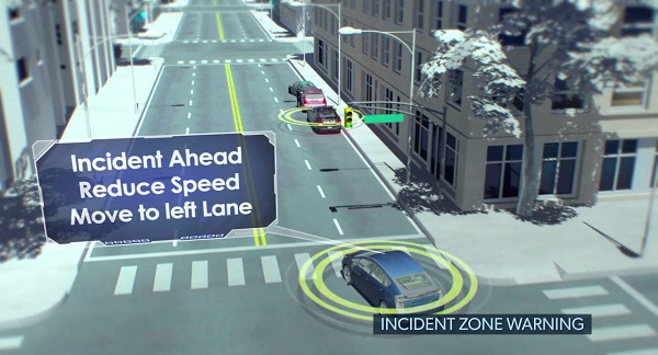
Figure 6. Illustration. Connected vehicle incident zone warning concept. Source: FHWA The connectivity of connected vehicles is classified into three types: V2V (vehicle-to-vehicle), V2I (vehicle-to-infrastructure), and V2X (vehicle-to-others, for example, pedestrians and other personal devices). V2V communication enables vehicles to wirelessly exchange information about their speed, location, and heading. This communication technology allows vehicles to broadcast and receive omnidirectional messages (up to 10 times per second), creating a 360-degree awareness of other vehicles in proximity. Vehicles equipped with safety applications can use the messages from surrounding vehicles to determine potential crash threats as they develop. The technology can then employ visual, tactile, and audible alerts or, a combination of these alerts to warn drivers. V2I technologies capture vehicle-generated data, wirelessly providing information such as advisories from the infrastructure to the vehicles that inform the driver of safety, mobility, or environment-related conditions. Enabled by a system of hardware, software, and firmware, V2I communication is typically wireless and bi-directional: infrastructure components such as lane markings, road signs, and traffic lights can wirelessly provide information to the vehicles, and vice versa. V2X allows vehicles to communicate with moving parts of the traffic system around them. Pedestrians, bicyclists, and personal devices are components of V2X interaction, which allow data exchange for storage, processing, and usage in controlling traffic. Connected vehicles may use a variety of communication media for data exchange, including DSRC, cellular, and WiFi. Connected vehicles are divided into three major categories of emerging data sources: Proprietary (commercial) connected vehicle systems; Open connected vehicle systems (U.S. Department of Transportation [USDOT]-sponsored technologies, DSRC); and Radio Frequency Identification (RFID), WiFi, and other technologies. Commercial connected vehicles include cellular connections to a private cloud from the vehicle's infotainment system or a third-party in-car system for tracking and data collection. Commercial in-vehicle systems are currently primarily used for gaining internet access for a passenger's devices. Other secondary uses are navigation, driver assistance, health monitoring, remote diagnostics, insurance evaluation, road user charging, and automated driving. Several private companies share information related to their commercial fleets with DOTs through aggregation of individual vehicle travel data into summaries of vehicle speeds on roadway links. Real-time link-speed data are currently invaluable to traffic management agencies because it is becoming more challenging for agencies to maintain their spot-speed detection equipment (i.e., in-pavement loop detectors, radar, and video). As of June 2016, HERE has published a voluntary (non-binding) connected vehicle data sharing standard that may accelerate the availability of trajectory-based commercial connected vehicle data to DOTs, assuming the information can be anonymized. To date, eleven major automotive and supplier companies have already joined the SENSORIS Innovation Platform now under the coordination of ERTICO. They are: AISIN AW, Robert Bosch, Continental, Daimler, Elektrobit, HARMAN, HERE, LG Electronics, NavInfo, PIONEER, and TomTom. On the other hand, open connected vehicle platforms are being developed by USDOT for mobility and safety application. The system relies on DSRC technology to send vehicle status data to other vehicles and infrastructure access points with very low latency. USDOT has supported the development of applications to improve the safety and mobility of connected vehicles.(64) Some of these applications are presently being tested at New York, Wyoming, and Florida. These applications rely basically on DSRC to generate and exchange BSM with other vehicles and roadside equipment at high frequency and low latency. In addition to BSMs, a probe data message (PDM) encapsulates a string of "snapshots" (a more comprehensive data element than the BSM) to provide vehicle trajectory information over a longer timeframe than the local trajectories shared by the BSMs. Both messages are shared with Roadside Equipment when the vehicle is within range, although there are alternative transmission methods being considered for transmission of PDMs through cellular communication. In the future, traffic management agencies and TMCs will have the technical ability to process, store, and use BSMs for improving traffic management functions. Connected InfrastructureThe concept of connected infrastructure (figure 7) is based on the emergence of the IoT. IoT refers to the concept of extending connectivity beyond the regular computing platforms such as personal computers and mobile devices, and into a range of non-internet-enabled physical devices and everyday objects. Once upgraded with electronics, internet connectivity, and other forms of hardware such as sensors, these devices can communicate and interact with others over the internet, and they can be remotely monitored and controlled. Connected infrastructure devices include traffic signals, ramp meters, closed circuit television (CCTV), DMS, vehicle detection, RWIS, flood warning, high wind warning, and a variety of other devices. Emerging devices include active traffic management applications of VSLs and lane control system (LCS). Integration and interconnection of corridor management and arterial control and freeway control systems are becoming more common, so also are transit and other demand management systems. For example, signals at intersections can be coordinated to be improved. Traffic preemption and priority is another ATM strategy that has proved effective in emergency management and vehicle-type control. Emergency or fire trucks can send a preemption signal to the intersection traffic light, thereby gaining priority over other approaches. The intersection controller can cut-off an existing signal phase to allow these priority vehicles to leave the intersection by passing the phase unto their approach. Certain vehicle types that can also hinder intersection throughput are equipped with preemption lights, therefore, allowing them to exit the intersection faster, reducing congestion. 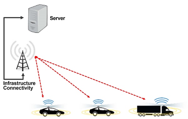
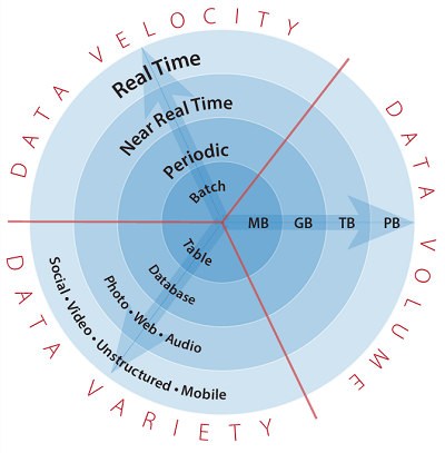
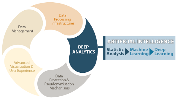
Figure 7. Illustration. Connected infrastructure architecture. Source: FHWA As data from connected vehicles and travelers provide the same information (at potentially higher resolution), connected infrastructure is still needed because the penetration rate of connected vehicles will not reach 100 percent for more than 20+ years. Currently, most agencies delete or archive old ITS infrastructure status information simply because existing database and processing system technologies are expensive and agencies lack the business case to expand to handle the volume. TMCs can use big data tools and technologies to gain analytical insights if more information from connected infrastructure could be retained and stored. Connected infrastructure can also benefit from the advancement of technologies, such as sensors, AI, and computer vision, to generate more data that are not available in the current systems. For example, connected infrastructure equipped with LiDAR sensors can generate an overall picture of all intersection object movement and, therefore, provide a sound foundation for real-time intersection and traffic signal control. Additionally, conventional video detection can be enhanced with computer vision technologies to generate real-time trajectory information of vehicles and pedestrians, enabling infrastructure to broadcast corresponding safety or mobility messages. While TMCs should be ready for emerging data sources from connected travelers and connected vehicles, empowering connected infrastructure with technologies will be extremely beneficial, particularly in the next decades when the penetration rates of connected travelers and vehicles are still low. Roadside Dedicated Short Range Communication/Basic Safety Message CollectionDSRC is an open-source protocol for wireless communication. It is intended for highly secure, high-speed wireless communication between vehicles and infrastructure. One of the main advantages is its low latency. The delays involved in opening and closing a connection are very short, on the order of 0.02 seconds, thereby providing real-time or near real-time information exchange within a connection ecosystem. Also, DSRC is very robust in scenarios of radio interference, and its short range (~1000 m) also reduces the chance of interference from distant sources. In adverse conditions, it has been observed to have a strong performance as well. Some of the applications involve transit signal priority and scene management for emergency services. BSM data are also transmitted through DSRC. High-definition Signal DataThe advancement of sensor technologies, such as video cameras and computer vision, allows the collection of exact vehicle trajectories near the intersection, which can be analyzed along with signal controller data. Additionally, with connected vehicles and infrastructure, traffic signal phasing and timing (SPaT) and intersection geometric MAP messages can be shared in real-time with surrounding vehicles for intelligent signal control. Active Traffic Management and Intelligent Transportation System DevicesITS refers to an advanced application that is designed to provide state-of-the-art services relating to different modes of transportation and traffic management. It allows roadway users to make better use of existing infrastructure in a more coordinated and smarter manner. The purpose of ITS technologies is to use communication systems that include wireless radio, Bluetooth and WiFi, microwave systems, and fiber optics to support the operations of highway systems. ITS allows the monitoring and management of roadways from TMCs. Elements of ITS include ATM, traffic cameras (CCTV), variable message signs (VMSs), and RWISs. Other Data SourcesReal-time Turning Movement DataA variety of sensor technologies, such as loop detectors, traffic cameras, and radar, have been developed for real-time traffic monitoring. Recent advancements make it easier to extract useful data for real-time intersection control such as the adaptive traffic signal control. Bluetooth ReidentificationBluetooth reidentification technology has been tested and accepted for over a decade. It provides reidentification through Bluetooth for travel time and OD. This has subsequently been used to improve understanding of driver route choice behavior in the past. The operation mode involves the tracking of Bluetooth signals from vehicles with mobile devices inside them, identifying the signal from a point, and reidentifying the same signal in another point. By comparing the time stamps for identification and reidentification, the travel time, and route choice behavior of drivers can be assessed. This is achieved using two or more Bluetooth identification sensors. Mobile SensorsA mobile sensor is defined as a device that records data about the environment where the vehicle is traveling through (rather than data related to the vehicle's status and performance). Mobile sensing enabled by GPS or smartphones has become an increasingly important source of traffic data. Mobile sensors reside in a vehicle and collect data only specific to this vehicle. GPS receivers, acoustic/ultrasonic sensors, and cell phones are examples of mobile sensors. Helicopters, Unmanned Aerial Vehicles (UAVs), and satellites can be categorized as more advanced mobile sensors. For example, UAVs can be flexibly deployed at key locations, such as incident scenes, for traffic monitoring and incident response. Another emerging mobile sensor is LiDAR point cloud and 3D camera data from connected vehicles. These data are collected to support automated vehicle operation, but could be valuable to traffic management functions, particularly incident management. Road weather management programs also benefit from mobile sensors. Integrating mobile observations (IMO) involve collecting weather and road condition data from government fleet vehicles, such as snowplows. The focus is on supplemental data from ancillary sensors installed on the vehicles, such as pavement temperature sensors, and it also includes native vehicle data such as windshield wiper status and anti-lock brake or traction control system activation. 2.4 Categories for Emerging TechnologiesOther than new data sources, many technologies are transforming ATDM practices and enhancing the state of the arts. These technologies include data technologies (e.g., big data, blockchain), decision support technologies (e.g., AI and ML), vehicle technologies (e.g., autonomous vehicles [AVs]), vehicle technologies, sensor technologies, and map technologies. Most of these technologies become relevant in the transportation field because of the increasing availability of "big" transportation data from connected travelers, vehicles, and infrastructure. Data TechnologiesData technologies (and new big data sources) are moving the transportation ecosystem at a fast rate. Emerging technologies drive virtually every other aspect of intelligent transportation. These sources range from sensing technologies such as LiDARs and lasers to mobile devices such as cell phones and iPads. These technologies are used to generate different types and volumes of data in batch, periodic, real-time, and near real-time speeds. Crowdsourcing and cloud computing are new concepts in data collection and storage, respectively. Concepts such as blockchain and big data are promising technologies that can make transportation data management and decision-making more secure and efficient than ever before. Figure 8 provides an outlook into core data characteristics in terms of velocity at which they are distributed, the variety, and the volume. Light Detection and RangingLiDAR uses ultraviolet, visible, or near-infrared light to detect objects in their sensing range. Light is reflected by the targeted object through backscattering. Using this reflected light, a point-cloud data of the object is drawn and identified by the sensor (for object recognition). Using the same approach, dynamics of moving objects are also obtained. Some uses are found in transportation planning, mapping, urban municipality, vehicle automation, and imaging. Autonomous vehicle manufacturers use LiDAR in measuring the state of moving objects around a subject vehicle. LiDAR has been used in adaptive cruise control (ACC) systems for automobiles. One of the most important benefits of LiDAR is its safety over other surveying methods. The use of LiDAR technology for road survey has proved safe, cost-effective, efficient, and reliable. LiDAR is continually gaining widespread acceptance, especially with the emergence of CAVs and self-driving cars. LiDAR also has the potential to be used as next-generation infrastructure sensors, such as for intersection traffic monitoring. The point-cloud data generated by LiDAR can be used to track the movement of vehicles and pedestrians and, therefore, provide trajectory-level control to enable higher levels of safety and efficiency. LaserKnown as light amplification by stimulated emission of radiation, a laser is a device that emits a beam of coherent light through an optical amplification process based on the stimulated emission of electromagnetic radiation. Applications include laser speed devices used by law enforcement to track the speed of moving vehicles. The infrared traffic logger (TIRTL) is another application that uses infrared light cones sent from a transmitter to a receiver situated on opposite sides of the road perpendicular to the flow of traffic. It classifies and records speed and volume for motor vehicles. This technology can be used to automate speed enforcement and as well as eliminate manual traffic volume data collection, which is usually time-consuming and labor intensive, and sometimes costly. Data from this source can also be used to harmonize speed in near-real time. Automatic Vehicle Location/Global Positioning System Probe-Based DataAutomatic Vehicle Location (AVL) is a computer-based system that collects and transmits information on a vehicle's actual location. GPS on the other hand, uses signals transmitted from a network of satellites orbiting the earth. By synthesizing both technologies, providers can obtain real-time traffic data, speed and travel time roadway analytics, performance metrics, OD data, route utilization, and more. AVL systems can track the real-time position of a vehicle. It uses a wireless communication system to communicate vehicle location to a central location or control center such as TMCs. AVL is applicable in fleet management by emergency response agencies, construction agencies, and trucking companies. In some cases, AVL is used on snowplow trucks to monitor their locations. Considering its extensive use, it can serve as a rich source of probe data from all these agencies, even at weather conditions that can be harmful to other probe data sources. Global Positioning System/Phone-Based Probe DataCell phone manufacturers have equipped most of their modern-day products with GPS capabilities. GPS-equipped mobile phones can provide speed and position measurements to the TMCs, allowing for better control and utilization of available infrastructure. The concept is similar to that described in the connected traveler's section. However, the concept here is limited to cell phones. Phone-based probe data have also been used to evaluate roadway pavement conditions by analyzing vehicle characteristics over a length of a roadway segment and recognizing inconsistencies. Identifying similar patterns in different phone-based probe data at a specific point on the roadway enables TMCs to prioritize traffic management strategy for congestion alleviation in real-time or near-real-time. Crowdsourced DataCrowdsourcing concepts coincide with cloud computing services. Crowdsourcing obtains services, ideas, and content from volunteers, part-time participants, and the general public rather than a specific group under contract, as in outsourcing, or traditional employees or suppliers. By canvassing a large crowd of people for ideas, knowledge, and skills, the quality of the information generated will be superior. Some examples of these location-aware mobile applications that provide value to the users are Moovel, Uber, or mobility-as-a-service,(38, 39) which are originally mobility companies that provide best modes transportation options such as transit, bicycle, or taxi. Waze is another database of crowdsourced data, providing TMCs with incidents and occurrences in real time. Transportation officials can provide solutions by diverting traffic or providing alternative route advisory to road users. This is also utilized for rapid emergency response. Internet of ThingsThis refers to the concept of extending connectivity beyond conventional computing platforms such as mobile devices and computers, into any range of non-internet-enabled physical devices and everyday objects. This enables an exchange of useful data between various components in a typical system without human-to-human or human-to-computer interaction. An example is the V2X communication systems. IoT enables V2X communication, which consists of V2V, V2I, and vehicle-to-pedestrian (V2P). By constantly analyzing real-time data, V2X designs a transport ecosystem where vehicles, infrastructure, and people are interconnected with each other to keep the environment safe from any type of crashes. Cloud ComputingCloud computing uses powerful data centers and IT infrastructure to efficiently and effectively deliver services and application to end users. It is an on-demand availability of data storage and computing power with limited active management by users. A cloud computing ecosystem (figure 9) relies on resource exchange to achieve coherence and economies of scale. This allows businesses, such as private travel information providers, to focus on developing their own application and interfaces without having to invest heavily in storage and computing facilities. The transformation of big traveler information data (which may be provided by a connected traveler) into useful resources for traffic management is made easier. Cloud computing provides agility for organizations, increased productivity, reliability, and data security, and is easy to maintain.  Figure 9. Illustration. Cloud computing ecosystem. Source: FHWA Big Data TechnologiesThis field treats ways to analyze, systematically extract information from, or otherwise deal with data sets that are too large or complex to be dealt with by traditional data-processing application software. Some of the challenges of big data include capturing, storing, analyzing, searching, sharing, transferring, visualizing, querying, updating, and sourcing the data. Big data and IoT work hand-in-hand. Data from IoT devices provide a mapping of device interconnectivity. Some of the technologies used to store and analyze data include Apache Hadoop, Microsoft HDInsight, NoSQL, Hive, Sqoop, PolyBase, EXCEL, and Presto. The big data technologies can be used to efficiently store, retrieve, and process transportation data of different formats and shared among different nodes. BlockchainBlockchain is a decentralized, distributed, and public digital ledger that is used in recording transactions across computers in a way that any modification cannot be done without altering subsequent blocks. It indicates a growing list of records, called blocks, which are linked using cryptography. Each block contains a cryptographic hash of the previous block, a timestamp, and transaction data. It is an open, distributed ledger that can record transactions between two parties efficiently and in a verifiable and permanent way. Blockchains are considered secure by design as they are usually developed to be resistant to modification. With blockchain, many people can write entries into a record of information, and a community of users can control how the information is modified. It can be a rich source of secure traffic data for agencies. Blockchain technologies have the potential to enhance the security and efficiency through decentralization for the next-generation traffic management systems. Data AnalyticsData analytics is a quantitative and qualitative approach used to derive valuable insights from data and involves many processes that extract and categorize data to obtain various patterns, relations, connections, and other valuable insights. It involves using data to "tell a story" by applying algorithmic or mechanical processes to derive a conclusion. Information and conclusions drawn can be used to optimize processes to increase the overall efficiency of a business or system. Various types of analytics include descriptive, diagnostic, predictive, and prescriptive analytics. Data analytics is an extremely important domain in today's data-driven world, where 90 percent of the data has been created in the last 2 years alone. As big data begins to grow in the transportation field, the value of big data analytics will continue to develop in TMC operations and ATDM solutions. Transactional DataExamples include commodity-specific, county-level cross-modal global freight flow data, supply chain and logistics management, purchasing behaviors, real estate marketing and valuation, and other economic transactions. Each of these may be useful to traffic management agencies and TMCs to gain a better understanding of travel patterns. Decision Support TechnologiesA decision support system (DSS) or technology is an information system that supports business or organizational decision-making activities. DSS technologies serve the management, operations, and planning levels of an organization (usually mid and higher management) and help people make decisions about problems that may be rapidly changing and not easily specified in advance — i.e., unstructured and semi-structured decision problems. DSS can be either fully computerized, humanpowered, or both. The advent of the web has enabled inter-organizational DSS and has given rise to numerous new applications of existing technology as well as many new decision support technologies themselves. Mobile tools, mobile e-services, and wireless internet protocols are beginning to mark the next major set of development in DSS technologies. There are decision support technologies that help utilize the data available in a data warehouse. These technologies help executives use the warehouse quickly and effectively. They can gather data, analyze it, and make decisions based on the information present in the warehouse. AI is a major DSS technology, which has been developed over the years and improved in the past decades. Description of DSS technologies, such as ML, DL, edge computing, and voice-driven assistants, is provided in the following subsection. Figure 10 shows the place of DSS technologies in deep analytics of data. Artificial IntelligenceAI, sometimes called machine intelligence, is intelligence demonstrated by machines, in contrast to natural intelligence demonstrated by humans. AI automates repetitive learning and discovery through data, adds intelligence, adapts through progressive learning algorithms, analyzes more and deeper data, achieves incredible accuracy, and gets the most out of data for its functionality. AI can be applied in traffic management, such as optimizing traffic SPAT, ramp metering rates, and optimal VSLs. AI systems, such as fuzzy logic and machine learning, can learn from historical data and experiences of online application, and adjust the AI model parameters to make improved decisions during the next episode (e.g., peak period traffic management). In addition to decision making, other AI technologies, such as computer vision and natural language process, to create data of increased amount and improved quality such that TMCs can implement optimal ATDM solutions on the fly. Machine LearningML is technically one critical competent of AI. ML is the science of getting computers to act without being explicitly programmed. It is defined as the scientific study of algorithms and statistical models that computer systems use to effectively perform a specific task without using explicit instructions, relying on patterns and inference instead. ML algorithms use a mathematical model of sample data to make predictions or decisions without being explicitly programmed to perform the task. They are used in computer vision applications. ML models can be supervised, semi-supervised, or unsupervised, depending on the method used to train the model. ML has been used for self-driving cars, practical speech recognition, effective web search, and a vastly improved understanding of the human genome. The advent of the big data age in transportation makes ML models possible and more powerful than ever before for TMC O&M applications. Deep LearningDL is a specialized form of ML and is usually referred to as deep neural network. ML workflow starts with relevant features being manually extracted from some training data such as images and using them to create a model that can recognize similar images in another set of test data. This is a subset of AI and ML that uses multi-layered artificial neural networks to deliver state-of-the-art accuracy in tasks such as object detection, speech recognition, and language translation. DL models are inspired by information processing and communication nature in biological nervous systems. The advantage of DL is to enhance the accuracy of the neural networks by making them deeper — forming a cascade of multiple layers of nonlinear processing units for feature extraction and transformation. DL is responsible for recent breakthroughs in AI such as self-driving cars, and intelligent voice assistants. This is mostly applicable in autonomous vehicle development, which enables learning through supervised or unsupervised approaches. Edge ComputingThis is the practice of bringing data closer to the edge of the network where the data are being generated instead of a centralized system. It is a distributed, open IT architecture that features decentralized processing power, enabling computing and IoT technologies. The benefits of edge computing are obtained from data-stream acceleration, including real-time data processing without latency. It allows applications and devices to respond to data almost instantaneously, as its being created, thereby eliminating time lag. This is a useful phenomenon for CAVs requiring real-time information use. Edge computing eliminates costs and ensures that applications can be used effectively in remote locations. Voice-Driven AssistantsDigital experiences enabled by virtual assistants are widely considered to be among the major recent technological advances and most promising consumer trends. A voice-driven assistant is a software agent that can perform tasks or services for an individual. Also called virtual assistants or intelligent personal assistants, they can perform tasks or services for an individual based on provided verbal commands. They are able to interpret human speech and respond via synthesized voices. Users of these assistants can ask questions, control home automation devices, and media playback via voice, and manage other basic tasks. Examples include Alexa by Amazon, Cortana by Microsoft, Google Assistant by Google, and Siri by Apple Inc. Voice-driven assistants enable additional applications in TMCs. For example, users can use this capability to report road conditions such as congestion and incidents, which will then be automatically sent to TMCs for traffic management purposes. Also, voice-driven assistants can be used in vehicle information provision mode, such as reading out traffic information to the motorists to avoid driver distraction and improve message comprehensive. Vehicle TechnologiesVehicle technology has produced considerable road safety benefits. The latest trend being the V2V and V2I communication between vehicles and/or roadside devices. Also, vehicle automation technologies, such as ACC, lane-keeping, and cooperative automation applications (e.g., cooperative ACC, cooperative merge), have great potential in enhancing and transforming ATDM solutions. These concepts make use of ideas ranging from sensing to AI to data storage. Their potential of being a source of useful data for real-time and/or near real-time traffic or transportation management and being a tool itself to regulate traffic (e.g., speed harmonization, cooperative merge) has made them a priority in the ITS and TSMO ecosystem. Connected Vehicle Data/Technologies
Automated Vehicle DataAutonomous vehicles (AVs), also regarded as self-driving cars, are part of the emerging transportation technologies. AVs sense their environment using sensor technologies such as LiDAR, video image recognition (computer vision), and radar. The combined operation of this sensing capability with automated steering, braking, acceleration, navigation, and routing systems, allows a vehicle to perform the driving task with little or no human input. AV adoption offers the potential for benefits such as reduced traffic collision due to the elimination of human driver errors occurring from distraction inattention and aggressive driving, as well as better system reliability and faster perception-reaction times.(67) Further benefits expected include smarter driving and navigation, reduced needs for parking spaces, and increase transportation access to the impaired or older driver. Data provided by navigation systems (i.e., high-accuracy GPS with inertial measurement unit [IMU]) and advanced sensors (i.e., LiDAR, and radar, camera) could be a wealth of new information that could be merged and mined for the public good, providing insights into the infrastructure, traffic flow, pedestrian movement, environment, and other elements of the developing smart cities. With real-time collection, data obtained from AVs can be sent to TMCs for active management or for a larger-scale transportation system performance evaluation. Sensor TechnologiesThere has been a tremendous development of sensor technologies in most of the recently launched devices. Different forms of sensing devices are being developed for different purposes. Ambient light sensors, proximity sensor, and GPS are some of the many common technologies used in smartphones. The use of sensing technologies in TSMO is witnessed in numerous aspects because they support the development and testing of emerging applications in safety, operations, and traffic control. Examples are sensors for assistance, traffic, comfort, security, safety, and diagnostics.(2) Advanced driving assistance systems are made possible by using vehicle position and detection sensors.(3) Cameras and radars are sensors used for traffic management and control. Safety applications of the sensors enable the development of automatic emergency braking systems through proximity and inertial measuring sensors.(4) Security sensors are used for access control and tailgating detection. Figure 11 shows some of the main uses of sensing technologies in transportation. 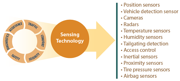 This illustration shows a circular graphic on the left side that consists of assistance, traffic, comfort, diagnostics, safety, and security. These factors are all part of the sensing technology shown as a circle in the center of the illustration. The Sensing technology points to a list of sensing applications that includes: Position sensors, Vehicle detection sensors, Cameras, Radars, Temperature sensors, Humidity sensors, Tailgating detection, Access control, inertial sensors, Proximity sensors, tire pressure sensors, and Airbag sensors. Figure 11. Illustration. Applications of sensing technologies. Source: FHWA Video Analytics SensorsIn many respects, the way to monitor video is similar to the way in which housing alarm technology has changed from a simple intrusion detection system in recent years into an integrated home automation solution. Likewise, video surveillance is no longer considered a way to protect the safety of people and property, but it is also a tool for improving business operations. The foundation of modern AI and ML technologies has led to a new wave of market participants and solution, part of which is in the transportation industry. Conventional traffic cameras are used to monitor visually traffic conditions in TMCs. Video analytics technologies can be applied to detect and classify individual vehicles and track vehicle trajectories at an intersection or over a stretch of highway segment, providing rich data set for next-generation TMC operations. Air Quality Monitoring SensorsMonitoring air quality is the systematic, long-term assessment of pollutant levels by measuring the quantity and types of certain pollutants in the surrounding, outdoor air. Air quality monitors can be used for outdoor air, indoor air, and ozone monitoring and control. Monitors are used to assess the extent of pollution, provide air pollution data to the public in a timely manner, support implementation of air quality goals, provide data to evaluate air quality models, and provide information on air quality trends. Sensor-based monitoring equipment, stations, and systems allow ambient pollution to be measured for less cost and complexity. Smart LightingThis is a lighting technology designed for energy efficiency. It uses high-efficiency fixtures and automated controls that adjust based on conditions such as occupancy or daylight availability. Using motion detectors, a smart lighting system senses motion and determines whether there are occupants in the space. The control unit then uses the signal to activate the switch/relay to turn the equipment on or off. This system of lighting can be very efficient in good environmental conditions. In irregular environmental conditions, there may be rapid and frequent switching, which may reduce lamp life. Smart light poles on the streets are sometimes installed with connected vehicle devices such that the control of lights can be closely tied to the ambient traffic conditions. Bluetooth/Wifi SensorsThese sensors allow for the identification of Bluetooth or WiFi signals emanating from the traffic ecosystem. By placing sensors at different points on roadways, each signal can be identified by a sensor and reidentified by another sensor in the path, therefore, leading to the evaluation of performance such as travel time, and the understanding of route choice behavior of drivers. Map TechnologiesMapping technologies assist in representing the surface of the earth and its constituents in a format that can be more easily observed and utilized. Fundamentally, GIS is a mapping technology that digitizes and processes segmented geospatial data. It is used for location planning and in sectors such as government, transportation, natural resources, law enforcement, utilities, and communication. The first step in mapping technology is capturing data. These data types include cartographic, photographic, and digital data to provide a complete picture. Crowdsourced map data, high-resolution map data, and real-time trajectory data are some of the emerging means of acquiring map data. Accurate maps, particularly emerging HD maps, are a critical foundation for many connected and automated vehicle-related applications and ATDM solutions. Crowdsourced Mapping DataThis provides a means to work together on the same task by the public. It allows application users to contribute information to their maps. This provides a simple way to enhance the interactivity of created maps. As citizens travel from one place to another, they can check-in on the maps and record the features observed that can serve as an update to the already existing database. Data gathered from this source can be used for TMSO. It can also become useful for autonomous vehicles navigation. High-Definition Map Data and other Asset Management SystemsHD maps include lane-level accuracy geometry, accurate placement of all traffic control signs and advisories, allowable traffic controls at intersection junctions, and major street furniture. Such HD maps are foundational data to support automated driving and connected vehicle functions. HD maps are likely to be provided by private companies to traffic management agencies, and thus could be considered a data source. The connected vehicle "Map" message, or geometric intersection description (GID) file, is also an important element that traffic management agencies and TMCs will need to manage. HD maps are used to record the location and performance of assets at any given time. For example, sets of data such as population, the location of specific buildings, and location of utilities, can be layered on top of a standard map. HD maps can be used for facility management and planning practices, enabling organizations to be more operational savvy. Real-time Trajectory DataData defined by position and momentum simultaneously. The advances in location-acquisition and mobile computing techniques have generated massive spatial trajectory data, which represent the mobility of a diversity of moving objects, such as people and vehicles. Many techniques have been proposed for processing, managing, and mining trajectory data in the past decade, fostering a broad range of applications. The data can include vehicle characteristics such as speed, elevation, and acceleration, relative to space and time. | |||||
|
United States Department of Transportation - Federal Highway Administration |
||