Transportation Systems Management and Operations in Smart Connected Communities
Chapter 2. Examples of TSMO in a Smart City – Meeting Community and Individual User Needs
Examples of emerging smart, connected communities span the globe and are found in Western Europe and Asia as well as in North America. Many have made major investments in the green economy through improvements in building design and construction, energy policy, and technology infrastructure. Many also emphasize improvements in mobility as critical to these initiatives. Such improvements include greater emphasis on non-motorized mobility, shared mobility, public transportation, and highly connected mobility infrastructure (including mobile applications that provide more comprehensive information about mobility alternatives) that give people access to the opportunities the city offers.
Transportation systems management and operations (TSMO) strategies can address operations objectives and user needs, such as reducing recurring and non-recurring congestion, and improving mobility, reliability, and security. Table 2 provides examples of TSMO strategies and how they would evolve within a smart, connected community context.
In this section, we provide a more detailed description of several smart mobility opportunities where TSMO managers and others can advance smart city concepts. Some of the examples show lower-level smart, connected communities capabilities while others show higher-level capabilities to illustrate how smart, connected communities' capabilities can be extended and expanded. The following TSMO strategies applied within a smart, connected community context are discussed in detail:
- Traffic Incident Management.
- Parking Management.
- Energy Management.
- Regionally Integrated Mobility Services.
- Urban Delivery Services.
| TSMO Strategy | Evolution of TSMO strategies within a smart, connected community context |
|---|---|
| Road Weather Management | Inform road users of pavement conditions (e.g., wet, icy, etc.) and providing a safe advisory speed range based on actual and real-time conditions of pavements. Use of "smart paint" at crossings and sidewalks to communicate wet or icy pavement conditions to enabled canes of visually impaired pedestrians. |
| Work Zone Management | Upstream diversion of vehicles based on predictive congestion algorithms for lane closures. Sensors and infrared cameras installed on temporary traffic control devices to detect delays and incidents and communicate information to emergency responders and transportation management centers (TMCs) regarding vehicle speeds, the number of vehicles involved in a crash, and the presence of vulnerable users involved in the collision. |
| Plan Special Events Management | Special event venues are instrumented to show, in real time, where people and vehicles are and where they are moving so that mobility managers can make real-time adjustments in signal timing, routing and related restrictions, and parking availability. Recurring special events (e.g., stadium, concerts) are planned collaboratively and real-time information is shared by all relevant services (e.g., emergency management services (EMS), law enforcement, and transportation/transit). Autonomous shuttles are deployed to ensure efficient access to the venue especially for individuals with disabilities. |
| Traveler Information | All mobility information is integrated through well-designed platforms providing access to public and private mobility options, including both motorized and non-motorized modes, as well as the cost and service levels for each choice. Real-time parking information (availability and pricing) is readily available and all payments are seamless and highly automated (e.g., smartphone app). |
Traffic Incident Management
Columbus, Ohio Connected Vehicle Environment
The anticipated outcomes of the Connected Vehicle Environment project are to enhance safety and mobility throughout the city's transportation system by utilizing connected vehicle technologies and applications with an emphasis on congested and high crash intersections and corridors. Safety applications are intended to be installed on multiple vehicle types including transit buses, first responder vehicles, city and partner fleet vehicles, and private vehicles. Applications will be deployed to ensure emergency vehicles and the Central Ohio Transit Agency (COTA) Bus Rapid Transit (BRT) fleet can utilize signal prioritization when needed to ensure safety and efficiency.
Traffic incidents require focused attention on: 1) meeting the immediate medical and safety needs of drivers, passengers, pedestrians, and others who are affected by the incident (e.g., by the release of hazardous materials or potential fires or explosions), and 2) addressing other travelers' needs to access their destinations in a safe and efficient manner, while minimizing the impact of redirected traffic on others.
In the context of a smart, connected community, data, technology, and organizations work together in a connected environment to meet these needs.
- For vehicles in the incident, on-board sensors inform public safety responders, the TMC, and near-by hospitals of the location, severity, hazardous materials (HAZMAT) likelihood, and likelihood of injury.
- Delay information is transmitted to other vehicles and infrastructure while the TMC and recommender systems11 offer re-routing options to users.
- Data from vehicles and infrastructure are integrated with incident management responses so that responders know what to expect in terms of personal injury, hazardous materials, damage to infrastructure, and queues forming due to loss of capacity. For example:
- Embedded sensors (e.g., accelerometers and other sensors in vehicles, sensors in roadways/rights of way) report the nature of incidents involving vehicles and the status of infrastructure elements such that other vehicles (including connected and autonomous vehicles) are immediately aware of the incident and potential delays as well as re-routing advice.
- Prior to any on scene response, medical services (EMS and hospitals) are automatically notified of the number and type of potential injuries based on sensor data from vehicles and infrastructure so that the appropriate response resources are identified and dispatched to the scene.
- First responders are notified of the number of people involved and how the vehicle and infrastructure have responded (e.g., airbags and other safety devices deployed, impact on infrastructure elements).
- Drones with appropriate sensors (e.g., infrared, visual, chemical detection) may be used for aerial surveillance to provide real-time reporting to mobility management services for updates on alternative routing and to identify damage to infrastructure (e.g., to bridge piers, tunnel linings).
- Mobility management services provide real-time information to travelers (drivers and passengers) so they are aware of potential delays and options available to minimize delays.
Illustrative Example of Smart Traffic Incident Management
Traffic incidents in smart, connected communities are expected to be much less frequent due to technology advances in both vehicles and infrastructure that prevent crashes and, when crashes do occur, they result in less injury to people and less damage to property. However, when they do occur, smart traffic incident management will respond faster, save more lives, clear the incident more quickly, reduce delays, and advise other travelers of travel conditions in ways that enable them to make better informed decisions regarding their travel needs. Figure 5 illustrates how smart traffic incident management is likely to work. This is not a complete depiction of all the data flows but provides some indication of how various entities may share data and communicate effectively. First, when the incident occurs, advance technology vehicles involved in the incident will immediately transmit information, including information about the number and physical characteristics of passengers, to first responders—emergency medical services, fire departments, and police. The vehicle may also transmit information to nearby hospital emergency departments advising them of the nature of the incident, which may include predicted injuries based on the crash characteristics (e.g., accelerometer data that give impact speed and direction and rollover status; airbag deployment data; and, in some cases, traveler physiological data— heart rate, blood pressure, respiration). The emergency medical technicians will be equipped with telemetry that enables them to communicate directly with hospital emergency staff so that they can provide real-time data to the hospital personnel.
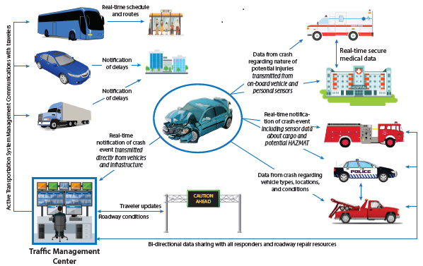
Figure 5. Illustration. Illustrative data flows in traffic incident management.
Data systems that meet security requirements for sensitive personal and health-related data may provide authorized first responders and other health care professionals with immediate information about the health history and conditions of the individuals involved in the incident. Integrated cargo manifest systems will provide real-time access to cargo information for any commercial vehicles involved in the incident, including information about hazardous materials that are on-board and could be released as a result of the incident. Trained and equipped response teams will be notified so that they can respond, using appropriate technology (e.g., robotic devices, drones) to assess the incident and determine what actions are needed to protect people, mitigate damage, and restore mobility.
As the event unfolds, the TMC receives information through connected vehicle data that is relayed to roadside infrastructure and from other sensors (e.g., closed-circuit television, in-road sensors) about the time, location, and nature of the crash so that it can immediately dispatch appropriate tow and recovery vehicles to the scene to begin roadway clearing as soon as possible and also direct any needed repairs to the roadway that are required to restore mobility. Sensors on autonomous vehicles (AVs) will detect delays and use available real-time data to reroute as appropriate. Signal systems and messaging systems are modified to give priority to first responders and other authorized vehicles while advising or directing other traffic appropriately. Law enforcement and fire departments (which may have personnel who are co-located at the TMC or are part of a virtual TMC) are immediately notified with information about the nature of the vehicles involved and including cargo information (e.g., hazardous materials) for heavy vehicles. Law enforcement, fire departments, and tow and recovery maintain continuous contact and exchange data with the TMC so that all parties have situational awareness and are able to attend to the injured, clear and inspect the crash site, capture any relevant information needed to document the crash for law enforcement purposes, and restore mobility. TMCs use real-time data to divert traffic to alternative routes and use adaptive signal control technology (ASCT) to adjust signal timing to accommodate demand on alternative routes. Road users are also informed about nearby or on-demand shared use mobility options such as electric pedi-cabs, taxis, public transit, bike share, and others.
If the incident results in damage to other utilities (e.g., power, fiber, natural gas), these utilities are notified immediately through their embedded sensors that detect service disruptions and they share data with the TMC and others, including their customers, advising them of any potential loss of service and the time until service will be restored.
Travelers whose trips are affected by the crash are immediately notified of the event through their on-board data systems. Vehicles in close proximity to the event may receive information through vehicle-to-vehicle (V2V) connectivity while more distant vehicles will receive information routed through the infrastructure by the TMC using either vehicle-to-infrastructure (V2I) capabilities or other communications channels (e.g., variable message signs). Autonomous vehicles will automatically reroute based on available information and routing alternatives and connected vehicles (including some that may also be autonomous) will transmit and receive information and will negotiate appropriate individual and collective strategies for minimizing delays due to the incident, taking into account effects on other facilities and mobility options. Travelers are informed of alternative modes, routes, travel schedules, and costs that could reduce or eliminate in-route delays so that they can plan accordingly.
Travelers (including commercial vehicle operators) have the ability to transmit messages to destinations updating anticipated arrival times based on anticipated delays or re-routing due to the incident. Transit services will immediately notify riders of any changes in routes or schedules affected by the incident and transit passengers will have the ability to notify others of expected arrival times based on real-time transit information.
Smart traffic incident management heavily relies on connectedness and real-time data sharing enabled by imbedded sensors in vehicles and infrastructure and connected through wired and wireless technology that gives system users, first responders, and system operators full situational awareness and the information needed to make informed decisions regarding the response to the incident and the allocation of response resources. The connectivity of the traffic incident management system with the smart, connected community infrastructure results in saving lives and improving the system's performance.
Parking Management
Parking management in smart, connected communities will address multiple needs, for both the vehicle operators and the parking manager. The parking management component of a smart, connected community will, for example:
- Reduce congestion that results from vehicles circulating while seeking available parking, including advising individuals of parking availability and pricing sufficiently in advance of their travel so that they can decide whether or not to bring a vehicle into the area.
- Help individuals find parking near their destination (through a smartphone application or integrated into vehicle) using sensors in parking lots that inform application users where parking spots are currently available (or when they are predicted to become available) as well as the cost to park (which may vary as a function of demand); offer efficient routing to available parking; provide a convenient means for paying parking fees (in spaces or parking lots/garages) and for maintaining awareness of time limits on parking; and, when permitted, extend parking time without returning to the vehicle.
- Help communities determine the amount, location, price, and type (e.g., curbside, garage, surface lot) of parking required. With greater use of shared vehicles, demand for parking below buildings or on streets may decrease, enabling cities to recapture land for people and allowing developers to make more productive use of available land.
- Facilitate parking resource management that enables parking managers to know the status of parking spaces (meters, garages, lots, ad hoc parking) and to manage parking pricing and availability as appropriate based on public and private sector parking policies, including dynamic parking control (e.g., by time of day, location, event status, street work or street cleaning/clearing).
- Support parking enforcement capabilities that enable parking agencies to enforce parking restrictions and access controls (e.g., street cleaning, snow removal, special events, permit parking), and prevent violations or intervene appropriately when parking violations occur, including notifying responsible parties that a violation has occurred.
To achieve these desired outcomes, smart, connected communities will implement strategies, technologies, and analytical tools to maximize access to available parking and to reduce congestion caused by vehicles in search of parking. This includes, for example:
- Smart parking meters (including parking kiosks) that notify individuals when time has expired, allow individuals to add time through a phone application, and could enable retailers to give parking credit or validation to customers.
- Advanced algorithms that assist parking managers in maximizing parking revenue and reducing congestion from cars looking for parking.
- Integrated parking credits and payments with businesses, enabling businesses to optimize customer access to stores.
- Real-time parking availability information and, potentially, parking reservations for commercial vehicles at truck parking areas and delivery locations to provide better use of available parking for commercial vehicles at truck parking areas along freeways and in commercial zones.
Illustrative Concept of Operations for "Smart Parking"
In its simplest form, smart parking integrates sensors or cameras that detect the availability of parking spaces (curbside or in parking garages or lots) and provides that information to individuals seeking parking so that they avoid unnecessary driving while searching for a parking space. As figure 6 illustrates, smart parking can provide much more, including revenue management, enforcement, and access control.
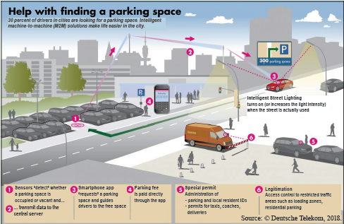
Figure 6. Image. Smart parking integrates data from multiple sources to support both those seeking parking and the parking management system.
Source: © Deutsche Telekom, 2018.
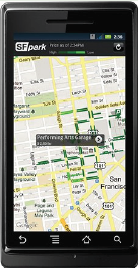
Source: San Francisco Municipal Transportation Agency.
Smartphone applications, such as that shown in figure 7, provide system users with information about available parking locations so that they can choose parking without driving around to search for a space. Some services are integrating parking information into vehicle on-board navigation systems so that drivers are notified of available parking locations as they approach their destinations.
Varying prices to regulate demand represents a further development in smart parking, with the objective of maintaining parking availability by regulating prices. Drivers pay for parking through a smartphone or by credit card or coins at a single or multiple space meter.
Energy Management
Electrical energy generation and distribution requires sufficient capacity to meet peak power demand, which typically occurs during the warmest or coldest periods and during periods of significant activity. While renewable energy sources can reduce dependence on fossil fuels and reduce greenhouse gas production, growing energy demand means that we will continue to depend on fossil fuels for the foreseeable future. However, if peak demand can be reduced, the amount of fuel needed to meet energy needs can be reduced since peak demand requires power companies to maintain "spinning capacity" even during lower demand periods. Growing penetration of hybrid electric and plug-in-electric vehicles means that we will become increasingly dependent on the electric power grid to provide the energy needed to recharge or top off vehicle batteries.
Smart, connected communities will implement smart grid concepts that include the potential for integrating hybrid-electric and plug-in-electric vehicles into the electrical power grid by providing public recharging stations where vehicles can recharge batteries or, in some cases, make power from fully charged batteries available to the power grid to offset peak demand and thus reduce generation requirements. Advanced algorithms will assist vehicle owners and operators in determining how much power is needed to maintain the charge for the required distances and how much power can be contributed to the grid while retaining the power needed to travel required distances.
TSMO can assist vehicle owners and operators by providing real time information regarding available recharging locations, pricing by location and time of day, and opportunities for earning "credits" by contributing to the grid during peak demand periods. This will require integration with power generations and distribution systems and sensors and networks to provide real-time status of charging stations. Smart parking applications can also include vehicle-to-grid (V2G) energy transfer to help manage peak electricity demand. Parking spaces with V2G technology will monitor energy demand and, with appropriate controls, allow parked plug-in-electric-vehicles (PEVs) to contribute energy to the grid during peak demand without depleting batteries below the minimum required to complete a trip to another location or, if the PEV remains connected to the grid, the batteries are recharged during lower demand (and, perhaps, lower cost) time periods. V2G strategies treat PEVs as distributed energy resource (DER) units and require integration of the smart parking with the larger energy management in the area.12 In some cases, shared mobility assets (vehicles, electric bicycles, and electric scooters) will be integrated into the electric grid along with incentives for recharging these assets during off-peak demand periods. This can include smart phone apps that locate assets in need of recharging so that users can earn credits by recharging them and returning them to designated locations for other users. PEV AVs can be directed to strategically located staging areas where they can avoid circulating while not in use and also be available to transfer energy to or from the grid as appropriate, depending on real-time energy demands.
Regionally Integrated Mobility Services (Transit and Shared Mobility Services)
Regionally integrated mobility services include light rail services, wheeled buses and vans, bike share programs, shared HOV/HOT lanes, and shared vehicles, all designed to provide scheduled and customized trip services based on user demand.
Integrated mobility services meet the needs of transit providers by improving load factors for transit vehicles by reducing non-revenue trips and empty seats on oversized vehicles. These services help transit operators match supply and demand, with more options for every rider. This integration relies on an expansion of private-public partnerships and building on the respective strengths of public transit agencies and private mobility services.
These services meet individual needs for more customized trips by integrating public transit services with private services for fare collection, scheduling (may offer subscription service for customized routes and schedules), and access to alternative modes, including car-and bike-share services.
Transit agencies in smart, connected communities are being redefined as mobility agencies, focusing on ensuring that commuters effectively transfer between mode choices. Transit agencies are partnering with Transportation Network Companies (TNCs) that provide pre-arranged transportation services with ride hailing or ride sourcing applications as a means of complementing their fixed-route systems and co-locating bike share services (docked and dockless) and bike parking at or near transit stops or stations. Rather than viewing TNCs as a threat to either transit or ride-sourcing, they can strengthen both—and their marketing and payment systems can be linked. In some cities, the transit agency's mobile ticketing and scheduling application ties into TNCs. The increased quality of service solves the last and first miles of service problems of fixed-route transit systems.
Paratransit for the elderly, physically challenged, or disadvantaged, has traditionally faced high subsidy costs and low levels of service. In some cases, paratransit vehicles, making many stops, are too large and costly to operate; in other cases, they make individualized trips to distant locations that are also costly. In smart, connected communities, these services can be provided on demand through ride sourcing applications, using the right-sized vehicle and providing individualized door-to-door service. Supply and demand are thereby matched, and at lower cost.
In a smart, connected community, TSMO's strategies are developed using data about current and potential system users. Shared mobility in a smart, connected community requires integration of data beyond that traditionally used in determining demand for transportation, including:
- Income and unemployment data – Identifying areas of high unemployment and underemployment where transit access by residents to jobs is inadequate.
- Job opportunity data – Matching the location of specific job opportunities and skill levels with targeted neighborhoods whose residents would have greater access through improved transportation.
- Land use data – Identifying areas where density is insufficient to make traditional fixed-route transit services attractive and cost-effective.
- Public health data – Targeting areas where prevalent health concerns for residents can be addressed by improving access to specific medical facilities.
- Crime data – Not only may the walking distance or time to fixed-route transit services be a deterrent to their use, the safety concerns of residents can be a deterrent as well.
Regionally integrated mobility services offer numerous opportunities for benefits to other elements within smart, connected communities, including:
- Connections for shared mobility. In a smart city, the smart phone applications for transit schedules, fares, and real-time conditions are fully integrated with those for ride sourcing. The American Public Transportation Association (APTA) has noted that access to information technology has been seen as a barrier to widespread adoption of new shared mobility options. It has further noted, however, "that transit information technologies are widely used across income and experience levels." Beyond transit users, a broad range of professionals would be able to utilize this improved transportation data. Social workers would be able to access this data to assist their clients in finding employment, along with public services. Human resource personnel would be able to target demographic data for recruiting, while increasing the likelihood that their employees can get to their jobs in a timely and cost effective manner. Crime data would be fully accessible for transit operators so they can determine where this may be a deterrent to transit use.
- Ride sharing. Using personal vehicles or shared vehicles can be enhanced through real-time virtual car pools that are formed based on real-time (or near real-time) demand for transportation between common origins and destinations.
- Bicycle and pedestrian mobility. Crowdsourcing riders to bike together on designated routes at the same time can alleviate security concerns. Smart lighting and sensors that detect the presence of bicycles, walkers, and runners can be installed along bicycle and pedestrian paths.
- Shared use of common vehicles. Collective ownership or access to vehicle fleets (autonomous or advanced automation) that can be reserved for use by individuals. The vehicles could be optimally positioned to accommodate demand patterns.
- Mobility as a Service (MaaS). Subscription services for on-demand mobility services (including pick-up and delivery of goods) could be used in lieu of vehicle ownership or leasing. Mobility services provided by private sector entities combined with advanced technology and analytics allow for asset use and service levels optimization. This may involve autonomous vehicles as well as TNCs that match mobility assets to mobility consumers (including delivery services).
Illustrative Example of Smart Regionally Integrated Mobility Services
A major corporate headquarters, and associated data center, are located in an office park in a suburban area 20 miles from the central business district. While the executive offices operate during daytime hours, the data center employs hundreds of people 24/7 – this includes programmers, hardware specialists, and maintenance personnel, at a broad range of skill levels. The company has been unable to find sufficient employees to fill these positions from the surrounding suburban communities. The human resources department has been trying to attract people from the city to fill jobs. The potential employees they are targeting live in the city because they have selected that lifestyle or, in some cases, because they cannot afford to live in the suburbs. In theory, these people are interested in filling these positions, but in practice, they face huge mobility challenges. They do not have cars either because they do not want them, or cannot afford them. The transit system has a rail station that is two miles from the office park. Further, the urban neighborhoods where potential employees live are mostly served by fixed-route bus systems, some of which require quarter-mile walks to the nearest bus stop.
During regular daytime working hours, the walk to the bus stop, the transfer to the rail line, and the last two miles to the office park (the 20 mile commute) could take almost two hours, and it can be prohibitively expensive. In off-peak hours, particularly for late-night shifts, the service levels deteriorate further, or may even be nonexistent. Transit operators cannot afford the even higher deficits that are involved in operating large, mostly empty buses in the late hours. For the last two miles from the rail station to the office park, current subsidized paratransit services provide a poor level of service, at a huge subsidy per rider.
Smart, connected communities offer a growing number of solutions that can address this challenge. Transit agencies are increasingly partnering with TNCs as a means of complementing their fixed route systems (see figure 8). Integrated smartphone applications are available to travelers which link marketing and payment, mobile ticketing, transit scheduling and access to TNCs. Transit agency apps have become door to door mobility applications instead. In some cases, commuters may choose to use shared bicycles to travel to and from transfer points and could arrange "bike trains" through ride-sharing applications to provide greater security while riding along bike paths.
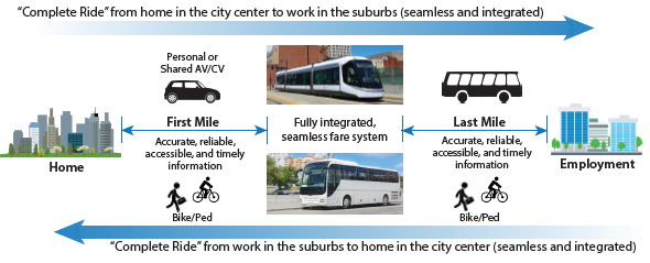
Figure 8. Illustration. Data for scheduling, notification, and payment are integrated throughout the trip.
The corporate headquarters can use this integrated mobility service for recruiting and retaining city residents for positions in the data center. While it previously found it too expensive to subsidize taxis or paratransit vans to provide the last few miles to the office park, their engagement with transportation network companies (TNCs) has brought these costs down considerably. This smaller subsidy is worth the investment to the company in that it can now attract the employees it requires at a broad range of skill levels. The company further improved the quality of this door to door service and reduced the subsidy cost by linking the smart phones of each employee who chooses to participate. They are able to determine when a train is late, and how many of their employees are aboard. This further lowers the cost of TNCs by ensuring that vehicles are not dispatched to the train station prematurely. It also enables the right size and number of vehicles to match the number of employees coming off each train. The increased quality of service solves the last and first mile service problem of fixed route transit systems.
These new reverse commuters to the office park now have expanded job opportunities. They can afford to reach these jobs without a prohibitive cost in money and time. Transit operators, in turn, can provide their off peak services more efficiently, having more customers to fill their vehicles, or when possible, reducing vehicle size or frequency.
Urban Delivery Services
The United States Department of Transportation (USDOT) Vision Element #4 for Smart Cities addresses urban delivery and logistics: This vision element includes the use of data or deployment of technologies to reduce congestion, improve safety, and protect the environment for a more efficient supply chain.
A smart, connected community approach to urban delivery services offers a range of opportunities and options for pick-up and delivery services. Several current and emerging models for urban deliveries take advantage of the smart, connected communities infrastructure and meet the needs of delivery services and businesses for more efficient, reliable trips. These include:
- Taking advantage of available capacity by scheduling deliveries during off-peak hours (see Figure 9), including providing secure storage for off-hours delivery and delivery to common delivery locations. This requires integration of information from delivery vehicles, receiving locations and staff, security services, and traffic or parking data along with guidance for minimizing effects of delivery on traffic flows as well as informing recipients of delivery location, time, and access requirements.
- Consolidating delivery points so that "last mile" deliveries can be made by smaller vehicles (including, for example, smaller commercial vehicles, bicycle couriers, drones, and other less intrusive means).
- Truck platooning on freeways and major arterials to improve efficiency and reduce congestion (e.g., shorter headways, greater throughput) integrated with roadway infrastructure to monitor commercial vehicle movements.
- Integrated information from major intermodal terminals regarding arrivals and departures to inform both carriers and other travelers regarding congestion in and around seaports, marine terminals, airports, intermodal rail yards, industrial facilities, and other locations with high density commercial traffic.
Illustrative Concept for Urban Goods Movement
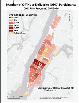
Figure 9. Image. New York City off-hour deliveries participants.
Source: New York City Department of Transportation.
NYC Off-Hour Deliveries (OHD) Program
Trucks and commercial vehicles both cause and suffer from congestion on New York City's (NYC) streets. Because of this congestion, deliveries made during the business day cost everyone—as stores often pass on to customers the expenses of wasted time, lost revenue, missed deliveries and parking tickets. In order to combat congestion, help businesses control costs, and improve air quality, the New York City Department of Transportation (NYCDOT) worked with Rensselaer Polytechnic Institute (RPI), and a group of stakeholders and research partners to implement an Off-Hour Deliveries Pilot Program, funded by USDOT, which ran from late 2009 through 2010.13
In a smart, connected community, shippers, carriers, and receivers (i.e., retailers, distribution centers) and infrastructure assets (e.g., parking, loading docks, designated loading/unloading areas) share real-time information regarding the availability of and readiness for goods transfer between the carrier and the shipper or receiver in ways that mitigate congestion and reduce emissions without introducing undesirable side effects (e.g., noisy delivery trucks in residential neighborhoods late at night). Additionally, in some communities, centralized urban distribution centers and load transfers to smaller delivery vehicles with well-coordinated schedules can reduce pedestrian, passenger vehicle, and truck conflicts and reduce the need for truck parking near heavily congested commercial districts.
In NYC, participants in the Off-Hour Deliveries Pilot Program agreed to shift their delivery windows to between 7 p.m. and 6 a.m. Receivers found that fewer deliveries during normal business hours allowed them to focus more on their customers and that their staff was more productive because they waited around less for deliveries that were tied up in traffic. Carriers found that their trucks could make more deliveries in the same amount of time; they saved money on fuel costs; and could use a smaller fleet by balancing daytime and nighttime deliveries, and that legal parking was more readily available. Their drivers reported feeling safer and less stressed. Figure 9 shows the level of participation in off-hour deliveries throughout Manhattan during the pilot.14
Building on the success of the pilot program, the NYC DOT will launch the expansion of the OHD program in 2018, targeting 900 businesses in Manhattan as well as businesses in Downtown Brooklyn, Flushing, and Jamaica. The OHD program expansion is part of a larger effort for the agency's forthcoming Smart Truck Management Plan, a comprehensive five-borough freight strategy.15
"Whole Foods Market Union Square has enjoyed the ability to take deliveries in overnight, serve our customers better and enhance our commitment to the environment through more efficient trucking operations."
— Mary Snow Thurber, Director of Receiving Whole Foods Market Northeast Region
Additional TSMO Strategies in a Smart Connected Communities Context
Arterial Intersection Control16
In smart, connected communities, network-level adaptive signal control systems will have greater awareness of real-time traffic flows, including access to available origin-destination data for traveling vehicles so that the system can anticipate demand (including expected turns) at each intersection and manage signals accordingly. V2I and V2V communications will provide guidance to vehicles (or to drivers, depending on the degree of autonomy) regarding optimal speed to minimize speed variation and delays at arterial intersections. This will require systems that capture and analyze data in real-time to determine how best to manage demand through signalized or controlled intersections.
In smart, connected communities, this can be accomplished through widespread adoption and implementation of ASCT integrated with both infrastructure sensors that collect and process data regarding the approaching traffic stream and with vehicle-to-vehicle (V2V) and vehicle-to-infrastructure (V2V) data from connected vehicles that communicate with arterial intersection control, which seeks to optimize traffic flow to improve travel time reliability. Integration of both archived and predictive data with real-time data will enable multimodal transportation management systems to anticipate changes in traffic flow and adjust signal timing accordingly, including giving signal preemption to emergency vehicles, signal priority to transit vehicles and, if appropriate, delayed signals to allow heavy trucks to pass through intersections when they have inadequate stopping distance.
Arterial intersection safety and traffic flow can also be improved by enabling traffic signals to transmit Signal Phase and Timing (SPaT) data to connected vehicles. SPaT will provide vehicles with the actual timing of each signal phase as they approach an intersection. This can be used to either increase or decrease the vehicle speed to avoid stopping at the intersection if possible.
Emergency Transportation Operations
During major weather events or other emergency situations when mobility is limited due to disruptions, critical personnel (e.g., health care professionals, public services staff) are often dependent on friends, neighbors, or others to provide transportation and this typically occurs without assistance from transportation agencies beyond what would occur for any other travelers during these emergencies. Properly equipped vehicles that are operated by qualified personnel can provide "on-demand" service during these emergencies, aided by application software and appropriate sensors, information systems, and algorithms that facilitate matching needs for transportation with available drivers and vehicles, including provisions for ride sharing.
During emergencies, transportation agencies responsible for managing and operating the regional transportation system can provide the linkage between those who need transportation to serve critical needs and those who have the properly equipped and authorized vehicles and expertise to transport individuals to their work locations. Additionally, using automated vehicle identification methods, transportation operators can provide special privileges to these vehicles during these events (e.g., special routing, signal priority, access to restricted parking, ride matching and route planning). Such services can support a variety of applications, including health care, power plant operations, and access to at-risk populations. Additionally, emergency transportation services and assets (public and private) that are integrated with other community services can also be dispatched to support movement of people and materials that are needed to execute critical life support functions and other high priority community services.
Beyond addressing the mobility needs of responders and matching individuals who need mobility with appropriate means of mobility, transportation agencies will be monitoring, managing, and operating transportation facilities to meet the needs of both individuals at risk and responders. This will likely include managing reversible lanes (or entire facilities, including access and departure points), implementing appropriate signal systems, providing accurate, real-time, accessible, and actionable traveler information and ensuring that transportation assets are matched with the needs of the community at large. It will also include continuous and timely communications (using sensors as appropriate) with agencies and jurisdictions that are affected by the emergency, either directly or indirectly as a result of mobilizing assets or moving people.
Finally, transportation agencies in smart, connected communities can use real-time data to identify and respond to system wide needs ranging from tracking and routing snowplows across multiple jurisdictions to detecting washed out bridges and roadways and restricting access to routes that are at risk of flooding or washouts or where downed power lines are on roadways.
An Example Smart Connected Community in Progress – Tampa, Florida
Like several other cities, Tampa, Florida embarked on wide-ranging applications of technology and procedures to improve mobility and quality of life. Following is a description of the efforts in Tampa that illustrate the diversity of applications and functions found among cities that are becoming "smarter" as well as some of the lessons learned during the process of implementing these "smart" projects.
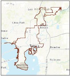
Figure 10. Image. Tampa, Florida.
Source: Google Maps.
Tampa is one of three communities in the nation deploying connected vehicle technologies as part of the USDOT Connected Vehicle (CV) Pilot. CV technologies will be deployed at 38 locations in downtown Tampa to address six different use cases, including street car safety, pedestrian safety, congestion mitigation, and better driver awareness through the use of V2V technologies.
In addition, the regional transit agency will be deploying its first AV shuttle for transit. This will be an AV service running down the Marion Street Transitway in Tampa, a 1.1 mile stretch. Another possibility is the MicroTransit facility, the Downtowner, in which 4-5 seat electric vehicles are summoned with a smartphone application. The Downtowner is a point-to-point, app-based service that extends the Tampa transit system.
Beyond actual transportation services, Tampa proposes to implement an innovative public, private, and academic "smart-paint" project. The Smart Paint project imbeds digital signals in pavement markings, permitting visually impaired individuals to use a smart cane to read digital information off of the street paint. The smart paint can also capture information from connected and autonomous vehicles to recalibrate positions, providing more accurate vehicle location information than can be obtained from cellular or GPS data, to arrive safely at the drivers' proper destinations. This is particularly important within cities where intersections are within close distances to each other. This project is part of Tampa's equitable transportation initiative.
Tampa is also leveraging information technology services to include a single platform that will permit users to plan an entire trip from origin to destination, and pay for and take the trip, which may include bicycle shares, water taxis, the AV shuttle, and other modes. In addition, Tampa is developing a decision support system that leverages machine learning and artificial intelligence algorithms to parse mobility data (including both historical and real-time volumes and crashes), and provide insights in 6-hour increments on the state of the system. This will help monitor systems better and stage resources based on algorithms that are predicting, to some extent, when and where incidents are likely to occur.
– Vik Bride, Smart Mobility Division Manager
City of Tampa
Through another public-private partnership, Tampa is working with the energy company to implement "smart lighting" where street lights are converted to LEDs and can also have sensors that provide other services, including gunshot detection, traffic counts, and weather and air quality monitoring. Tampa has additional smart city initiatives in e-healthcare, telemedicine, and education. The idea is to leverage a myriad of emerging technologies and different agencies and partners to develop better services throughout the community.
Lessons learned from Tampa's experience in developing and implementing "smart city" initiatives include:
- Begin by developing a framework that reflects the context of the region of interest.
- Consider changing demographic characteristics, exposure to the effects of climate change, changes in density (e.g., growing urbanization) and related preferences in transportation (e.g., walking, bicycling, ride sharing), and cultural activities.
- Ensure regional buy-in and support from regional leadership and having a clear benefits narrative and a political narrative that explains the reasons for advancing projects.
- Ensure that public, private, and academic partners collaborate effectively and that the community is fully engaged. Public-private partnerships will be essential so commitment to such partnerships is as critical as is commitment to subsequent operations and maintenance of these initiatives.
Challenges and Limitations
As with any disruptive change, smart, connected communities and related TSMO activities present challenges that need to be anticipated and addressed. Beyond the obvious technical and institutional challenges that characterize every major project, smart, connected communities' initiatives are typically characterized by high levels of integration and connectivity that enable data sharing and access to both archived and real-time information. Consequently, these initiatives will need to be particularly sensitive to:
- Public Acceptance. Many of the smart, connected community initiatives will offer new opportunities and benefits to system users but may also require them to adapt to new technologies, new concepts, and new ways of accessing services, including mobility services. Public agencies and private entities will need to address concerns and be attentive to the needs of those who are likely to resist change. Effective outreach and focused information will be required to overcome resistance.
- Asset Management. As more cities and communities will become heavily connected and embedded with advanced technologies, cities and communities need to have the ability (financial and structural) to maintain a state of good repair to the technology assets being deployed and to update deployed systems as needed due to obsolescence and newer capabilities.
- Security. Cyberattacks can cause physical harm to people and property by compromising sensitive information and cyber-physical systems. Appropriate security measures and mitigation plans should to be in place.
- Privacy. As more information is collected on individuals, vehicles, and movements and shared with a wider collection of users, loss of personal identifiable information (PII) and Health Insurance Portability and Accountability Act (HIPAA) protected information will become an increasing risk, especially if it can be accessed by third parties that may use it to exploit vulnerable populations or to implement business practices that disadvantage specific populations.
- Equity. As more technology and capability become available to those who can either afford it or have the skills to exploit it effectively, communities will run the risk of increasing inequity unless specific measures are taken to include disadvantaged populations. While smart, connected communities may offer capability and capacity that enable individuals to access services and information not previously accessible, they may also exacerbate deeply imbedded differences among populations that are early adopters or regular users of technology and those who lack access to or familiarity with technology. Smart, connected communities will need to avoid "technology deserts" where some segments of the population are underserved and are unable to take full advantage of the new capabilities for accessing high quality services (e.g., mobility, health care, education, and consumer goods). Well-conceived smart, connected communities innovations can dramatically improve the lives of everyone in the community, but care must be taken to ensure that these innovations do serve the needs of the entire community.
- Obsolescence. With rapidly changing technology, smart, connected communities will need to be particularly careful in choosing solutions that are easily upgraded and, in some cases, replaced with improved solutions. Retaining old technology when more effective, safer solutions are available could put the city or community at risk when incidents occur.
- Workforce Development. The development, support and progress of smart, connected communities and TSMO cannot be achieved without a proficient and skilled workforce. Educational training can be provided by developing and implementing new curriculums at universities and educational centers.
- Openness. Smart, connected communities will need to find the balance between proprietary solutions that may be more effective and secure in the short run and open systems that accommodate multiple solutions from different providers, but may be more vulnerable to attack or compromise if not properly secured and protected. Smart, connected communities will need to insist on interoperability using adopted or de facto standards so that new or additional capabilities can be integrated with existing technology without requiring them to replace existing systems.
- Collaboration. The evolution of smart, connected communities and TSMO strategies with time will also most probably result in the creation of new partnerships with stakeholders not previously considered. TSMO and smart, connected communities frameworks need to be developed in a way to allow the integration of new key members.
- Economics. While many of the benefits of smart, connected communities may be obvious, they are likely to be widely distributed to a variety of consumers throughout the community and may require focused investments by a variety of public agencies and private investors who see the public good or can realize profit from their investments. Public agencies will need to show how these investments produce benefits in order to obtain funding or to attract private sector partners who will make the investments needed to realize the benefits. Many smart, connected community benefits are derived from the "network effects" of large scale deployment and use of available technologies so scaling deployment to achieve scale will be an important consideration in making the business case for smart, connected communities' innovations. Systems engineering concepts become increasingly important to ensure that decisions take into account the entire life cycle of investments (total cost of ownership) and that the investment decision reflects the needs, values, and requirements of the larger community.
- Business Processes. Many of the innovations and concepts in smart, connected communities require considerable collaboration and coordination among public and private sector agencies that may traditionally work in functional and organizational silos. Procurement policies and practices may require adjustments that allow ownership, management, and control to be negotiated. Depending on the application and procurement practices, they may need to be modified to allow for shorter cycle times that reflect the rapidly changing nature of emerging and evolving technologies.
Considerations for Integrating TSMO into Smart Connected Communities Principles
Integrating TSMO into smart, connected communities requires careful coordination with local and regional planning agencies. As cities and communities evolve to embrace smart, connected community concepts, planning for operations will require a widening set of stakeholders.
Transportation system managers and operators responsible for TSMO will need to be more aware of opportunities to support other "smart" functions in energy, health care, environmental services, and other public and private functions and be prepared to take the lead in advancing services and capabilities that will require support from other functional areas (e.g., as will be the case with several of the areas described above).
As mentioned previously, "[a] smarter city is one that uses technological innovation to integrate public services, connect with citizens and enhance productivity. . . . But by the same token, a city without a clear direction will often invest in new technology without broader purpose, creating disparate pockets of innovation that fail to result in community-wide change."17 And similarly, "Transportation is not just about roads, transit and ride sharing. It's about how people access opportunity. And how they live."18Smart, connected communities define goals that relate to how people live and then identify institutional relationships, policies and procedures, innovative technologies, and economic models that enable them to reach these goals. The foundational element of connectivity is made possible through ubiquitous sensors, extensive networks and data sharing, advanced algorithms, and widespread distribution of appropriately filtered and presented information to support both system management and control and user choice.
As smart, connected communities continue to become more fully integrated and more dependent on critical technologies to provide the services they need, they will also need to give greater attention to safety, security, privacy, and equity since integrated services will create new vulnerabilities and may be difficult for some members of the community to access without assistance. Additionally, because of the relatively short life cycle associated with information technology and related physical systems, smart, connected communities will need to make strategic choices that enable them to upgrade or replace aging technology without causing major disruptions to critical services that residents and visitors come to expect. Lastly, TSMO in smart, connected communities requires careful and strategic planning to ensure that investments produce the desired outcomes. Many of these investments will rise to the level of major investments and will need to be integrated into the larger planning process to ensure that planning for operations receives the same consideration as other strategic investments.
The Way Ahead for TSMO and Smart Connected Communities
What can transportation systems owners and operators do to advance TSMO within the context of smart, connected communities? Here are some ways to get started:
- Be intentional in developing relationships with colleagues from other agencies and organizations (e.g., industry groups, private sector entities) and engage in discussions about the vision and goals for a smart, connected community.
- Identify ways to leverage investments in information and communications technology and related infrastructure to support both TSMO strategies and other smart, connected community initiatives (e.g., sensors, communications networks, data).
- Invite representatives from other agencies and private sector entities to engage in scenario planning and planning for operations activities where they can help develop and take leverage of TSMO investments that can support their functions and also identify new ways to integrate functions and technology to support multiple objectives (e.g., economic growth; access to employment, health care, education and other public services).
- Identify and communicate ways that the regional intelligent transportation systems architecture complements smart, connected community initiatives and can help advance progress toward community goals and objectives.
- Engage with vehicle manufacturers and infrastructure developers to ensure that TSMO investments take full advantage of emerging technologies and capabilities and that TSMO investments anticipate innovations that can further integrate with other smart, connected community initiatives.
- Develop messaging for community leaders, elected officials, and the public at large regarding the benefits of a smarter, more connected community that offers safer, more secure, more reliable, more accessible, and more affordable mobility options designed and managed to support community-wide goals and objectives.
11 "Recommender" systems use data and algorithms to suggest alternatives that are most likely to satisfy user needs based on prior experience (e.g., "learning") and user preferences. [ Return to note 11. ]
12 Vincenzo Bonaiuto, Fausto Sargeni, "A Matlab Simulink model for the study of smart grid—Grid-integrated vehicles interactions," IEEE 3rd International Forum on Research and Technologies for Society and Industry (RTSI) 2017, pp. 1-6, 2017. [ Return to note 12. ]
13 New York City Department of Transportation, "Off-Hour Deliveries (OHD) Program," Web page. Available at: http://www.nyc.gov/html/dot/html/motorist/offhoursdelivery.shtml. [ Return to note 13. ]
14 For additional information, visit https://www.ohdnyc.com/ or contact the NYC DOT Off-Hour Deliveries Program by email at ohdnyc@dot.nyc.gov or by phone at 212-839-6670. Information on other NYC freight initiatives can be found at: http://www.nyc.gov/trucks [ Return to note 14. ]
15 New York City Department of Transportation, "Trucks & Commercial Vehicles," Web page. Available at: http://www.nyc.gov/html/dot/html/motorist/trucks.shtml. [ Return to note 15. ]
16 For more information, visit: https://ops.fhwa.dot.gov/atdm/index.htm. [ Return to note 16. ]
17 The Brookings Institution, "Getting Smarter about Smart Cities," Past Event, December 9, 2013. Available at: https://www.brookings.edu/events/getting-smarter-about-smart-cities/. [ Return to note 17. ]
18 Columbus, Ohio Mayor Andrew J. Ginther's comments regarding the city's Smart Cities initiative. [ Return to note 18. ]