Collaboration Across the Road Weather Enterprise: The Pathfinder Project
APPENDIX D. SPECIFIC COLLABORATION EXAMPLES OF PATHFINDER TEAMS
SURFACE TRANSPORTATION WEATHER COLLABORATION: THE PATHFINDER PROJECT IN UTAH CASE STUDY
Weather collaboration for surface transportation in Utah occurs primarily between four entities, the Utah Department of Transportation (UDOT), the private sector WeatherNet, LLC, and Weather Forecast Offices (WFO) Salt Lake City, UT (SLC) and Grand Junction, CO (GJT). These parties are collectively referred to as the Utah Weather Partners. For a road weather impact study, the University of Utah was also brought into the Utah Weather Partners fold. Out of this effort, collaboration occurs across a broad spectrum of activities and events, with the goal of maximizing societal benefits with respect to safe and efficient vehicular travel. Winter storms, high wind, dense fog, severe thunderstorms, flash flooding, and wildfires are among events for which collaboration occur. While discussion of the meteorology or hydrology of the event sometimes occurs, the focus is on impacts and messaging, in-line with the emphasis of the partnership that delivery of impacts-based information and consistent messaging should result in informed decisions and improved driver responses. Collaborated information is then distributed by the Utah Weather Partners and media via multiple mediums.
To illustrate the efforts in Utah, collaboration for a winter storm event in January 2013 is highlighted below. The event featured a band of heavy snow which moved into the Salt Lake City metropolitan area around 2200 UTC (3:00 PM MST) on 10 January 2013. With cold road surface temperatures, rapidly cooling air temperatures, and high anticipated snowfall rates, it was expected that snow would rapidly accumulate on area roadways during the evening commute. Confidence was high that this event would have a significant negative impact on driving conditions. Thus, several days before its arrival, collaboration and messaging began in an effort to provide notification of possible impacts. By late evening, most of the Salt Lake Valley had received between 4 and 8 inches of snow, with the majority of the accumulation during the evening commute.
Collaboration in NWSChat, an instant messaging program used by the National Weather Service (NWS) and its partners, began three days prior to the storm. At this point, dense fog was also being discussed. By the following day, 8 January 2013, collaboration was occurring in NWSChat, including setting a time for a midday coordination call. During the call, event timing, impacts, including anticipated road conditions and routes to be effected, and precautionary messages were coordinated. Later in the day, a link to a YouTube event briefing was produced. Similar coordination continued into the day of the event, when collaboration in NWSChat and conference calls shifted to specific timing of the snow impacting the commute. A chat message issued the morning of the storm stated “NWS, UDOT has decided to post VMS signs reading "Winter Storm xxxx Time" These signs are currently indicating road impacts in Ogden at 3 p.m., SLC at 4 p.m., Provo/Utah County at 5 p.m. We are expecting the evening commute to be impacted significantly by this storm.” This information was reflected in UDOT variable message signs (VMS), with information also shared via UDOT Road Weather Alert graphics, 511 service, and social media. At the same time, this information was distributed via WFO SLC legacy text products, Weather Story graphics (example in Figure 19), and social media.
This event occurred during a road weather impact study, so information on motorist behavior throughout the Salt Lake Valley was available. A targeted survey, developed collaboratively by the Utah Weather Partners and University of Utah, and administered by PEGUS Research, gathered information from 400 respondents. The responses for each event were used to:
- Assess the weather information that drivers possessed prior to and during a storm.
- Determine sources of weather and road information.
- Explore uses, specifically modification of travel and/or commute plans, based on event information.
- Examine perceptions of storm impacts and severity, including driver satisfaction with information provided.
Of note, the survey revealed that 62% of survey respondents noted they changed their schedule,
26% changed their route, and 13% decided not to travel. Comparison of the self-reported actions from interviewees with data obtained by UDOT from the Performance Measurement System (PeMS) shows the verbal reports are fairly well supported. Figure 20 indicates the afternoon
peak commute time shifted from a typical peak at 5 p.m. (red) to an actual peak at 3 p.m. (blue), with traffic volume at the typical peak commute period reduced by 43%.
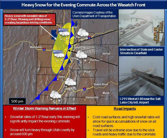
Figure 20. Photo. Utah Weather Story Example.
(Source: National Weather Service)
Figure 20 shows an example of a weather story graphic issued by Weather Forecast Office (WFO) Salt Lake City, UT (SLC) depicting the timing of the weather system into the area, anticipated snowfall rates, impacts, and UDOT web cameras. Figure 21 shows traffic data collected by the Performance Management System (PeMS), specifically aggregate vehicle miles traveled (VMT) by hour in the study area on 10 January 2013 during a snow event (blue line)
and on a control day on 17 January 2013 (red line). The vertical shading indicates the time of the peak commute during the snow event (blue) and on the control day (red).
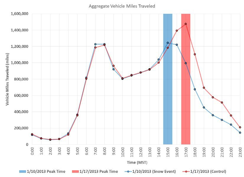
Figure 21. Graph. Aggregate Vehicle Miles Traveled versus Time of Day.
(Source: Utah Department of Transportation)
WYOMING DEPARTMENT OF TRANSPORTATION PATHFINDER SUMMARY
The introduction of Pathfinder was well-received and a natural "next step" for the Wyoming DOT (WYDOT). The project helped improve methods of communication and relationships with weather partners while increasing the quality of information shared with the traveling public. There is little doubt that consistent weather impact messaging has helped both the weather service providers and the DOT get the message out to the traveling public about important weather events.
Starting From Scratch
Prior to Pathfinder, WYDOT’s Dynamic Message Signs (DMS) were used primarily for displaying current road conditions (eg: Slick Roads, Wet Roads, Reduced Visibility, etc.). There was limited communication and understanding of weather messaging between WYDOT and local National Weather Service Forecast Offices. WYDOT’s two private weather providers each
played individual roles in providing weather support. To implement Pathfinder, several meetings were set up prior to the winter season. All parties involved discussed a strategy for seamless communication, establishing message consistency (to the public and on social media) and best practices for sharing that message with the traveling public. To keep the project from becoming too overwhelming, the focus was narrowed down to just the I-80 corridor through the State. This main interstate was equipped heavily with RWIS, DMS and VSL signs - plenty of technology to provide information to the travelers.
The Pathfinder Project
One of the first steps was to initiate communication and start a discussion between WYDOT and the weather enterprise as early as possible prior to a significant weather event. Discussions took place frequently ahead of incoming weather events, especially in regards to how significantly travel will be impacted. There were three main discussion points:
- Highlight the most significant impacts.
- Location.
- Timing (expected beginning and end-times).
An impact-message (based on high confidence in the latest weather forecast) was carefully crafted and agreed upon by all parties, then disseminated to the public through WYDOT’s various messaging systems. Message delivery was primarily through DMS, Highway Advisory Radio’s and Email and Text Message Alert Systems. Small refinements were continuously made during the first winter season of practice, including improving the timing of message-delivery and creating specific forms to make message-delivery easier for TMC operators.
The Success of Pathfinder
The implementation of Pathfinder created a formal and systematic pathway for all weather partners to communicate and collaborate on upcoming weather that will impact travel. The spirit of cooperation has been outstanding between private partners, the National Weather Service and WYDOT. There is a common goal - to provide the public with important decision-making information so that they can make informed travel decisions. It only makes sense to work together.