Collaboration Across the Road Weather Enterprise: The Pathfinder Project
APPENDIX A. THE PATHFINDER PROJECT - BACKGROUND
The Surface Transportation Weather Collaboration Pathfinder Project, which has come to be known familiarly as the "Pathfinder Project," was designed to assess the Department of Transportation (DOT)-to-weather enterprise collaborative model in States that differ operationally (Refer to the five operational cases in Appendix G). The administration of the project was jointly led by the National Weather Service (NWS) and DOT leadership, managing the project in a collaborative manner, with significant input from private sector participants.
The Project tested the collaborative model in four adjacent States (California, Nevada, Utah and Wyoming) each with a different NWS-DOT-private operational configuration (detailed below) to explore the feasibility of this cross-entity collaboration framework in different DOT settings. Lessons learned over the 2014-2015 winter season were used to create this guidance document
for other DOTs to utilize.
PROJECT APPROACH
Objectives
By testing the collaborative model in States with various operational configurations (Refer to five cases in Appendix G), the ultimate objective of the project was to see if the Utah model is transferable to other partner agencies throughout the country. The lessons learned in these project States were used to provide guidance for developing collaborative relationships between DOT Traffic Management Centers (TMCs), NWS Weather Forecasting Offices (WFOs) and private sector partners of any operational configuration.
The project also sought to examine:
- The extent to which collaborating improves operations at each agency.
- The extent to which culture change is possible in the NWS, DOTs and private sector.
- How the partners can create an environment in which the private sector views collaborating with the NWS as good for business.
Assumptions and Constraints
A major assumption of the project is that there is a causal link between traffic response and the impact-related message released by the DOT and NWS. Making that link, however, involves a number of individual assumptions, including:
- The majority of travelers seeking information about the event received the DOT/NWS message.
- The message was widely distributed because the media relayed the same message released by the DOT/NWS.
- The message was much more acceptable or believable by the public because there was agreement from multiple sources.
- Those who altered travel plans did so in response to the message.
These assumptions can be tested through social and behavioral studies. Social science indicates that message consistency is a critical aspect for getting the public to respond to warnings (Sorensen, 2000). Years of experience in Utah has also showed that drivers modified their behavior when consistent, clear messages regarding weather impacts were relayed to them prior to events. One such study was conducted in the Salt Lake City metro area during January 2013,
and assessed drivers' sources of weather and road information, their decisions to modify travel or commute plans, and their perceptions of storm impacts and severity. A couple of key findings were (1) the public uses multiple sources to gather information about an upcoming event, but most frequently accesses local media; (2) that the forecast messages relayed to the public do
cause motorists to change their travel plans; and (3) most frequently travelers decided to change their travel schedule or route, with a smaller, but not insignificant portion of respondents deciding not to travel at all. Social studies should continue to be done to ensure the public is receiving the information it needs to make important decisions about travel.
During introductory and instructional meetings with management from State DOTs, NWS WFOs and private sector consultants from the four project States, it was requested that each agency put forth equal participatory effort into collaborating and documenting the results. There were separate meetings with private sector partners involved in the effort to try to understand and address concerns they may have with sharing their own proprietary knowledge and expertise
with the NWS. There is much to be learned from the private sector on how to best accomplish the goals of the collaborative effort. They were encouraged, during the project, to note ways in which collaboration impacted their business, whether positively or negatively.
EVALUATION LOCATIONS - SELECTED STATES
The four States identified for testing in this project were California, Nevada, Utah and Wyoming, which also happen to be active members of the I-80 Corridor Coalition. They were chosen because:
- The States' DOTs represent four operational configuration cases (Caltrans – Case 3, Nevada DOT – Case 2, Utah DOT – Case 4a, Wyoming DOT – Case 1).
- I-80 is a major commercial trucking corridor.
- There are only one or two WFOs per State along the corridor, simplifying the lines of communication during the testing phase.
- The States offer a mix of metropolitan and rural roadways.
- They offer a mix of mountain summits and open plains, which experience everything from snow and wind to dust and wildfire.
- Most major storms that come across the Intermountain West will impact all four States, offering a clear comparison of the impacts felt in each State and how the States collaborate across borders.
- There are already established relationships and communication protocols between the States involved in the I-80 Corridor Coalition, simplifying project coordination and initiation.
Specifically, the WFOs involved in the project were: Sacramento, Reno, Elko, Salt Lake City, Riverton and Cheyenne. Refer to Figure 11 for the locations and coverage of these WFOs.
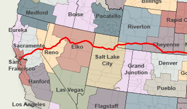
Figure 11. Photo. Weather Forecasting Offices County Warning Areas in the Project
Region. The Location of I-80 is Denoted by the Bold, Red Line.
(Source: Adapted from National Oceanic and Atmospheric Administration website)
DATA COLLECTION
After each event, the partners were asked to document their collaborative efforts individually and their results and perceptions of the collaboration. A questionnaire was sent out to each State after the events. The motivations of the questionnaire were clearly stated for the personnel to see each time it was filled out; and they are
- To help you identify successful collaboration habits.
- To help you identify challenges, opportunities for improvement and goals for the next weather event.
- To prepare you for after-action review discussions with your partners.
- To help you decide what data are pertinent for archiving.
- With your answers from all other weather events this year, to build a reference library for easy post-season review.
- To assist in the effort to develop guidelines for other State DOTs, WFOs and private firms.
Each DOT and WFO was asked to archive as much pertinent data as possible during the course of events for post-event and post-season review. Data collected includes:
- Traveler Information. Variable Message Signs (VMS) and 511-messages, social media, local media stories.
- Road Weather Info. Road Weather Information System (RWIS) data, camera images, maintenance logs.
- Collaboration. Phone calls and emails, NWSChat logs, in-person meetings.
- Public Response. Traffic data, news stories, public feedback.
The partners could refer to checklists (shown in Appendix H) to ensure all pertinent data was collected, either during each event, or at the end of the season.
After-action reviews (AARs) were held at the partners' discretion. AARs serve as a format to bring all partners to the table after an event to review the details of the event, the role each partner played, what worked well, what needed improvement, and what actions need to be taken to see improvement. AARs can also be held at the end of a season for reviewing the entire season.