Regional Assessment of Weather Impacts on Freight
Chapter 2. Methodology
Selection and Definition of Study Areas
In an earlier memo this project identified 13 recommended study areas after conducting thorough research into each site’s weather patterns and available data sources. These recommended study areas are listed in table 3, along with their weather focus (the primary weather-related reason for recommending the study area), transportation focus (the highway component that will be investigated), and potential freight focus. The freight focus was identified primarily to make sure that an adequate variety of commodity shipments and economic activities were represented in the study. Data required to identify specific commodity flows for a specific roadway were not yet available. The initial 13 recommended study areas included two reserve study areas—Birmingham, Alabama and Salt Lake City, Utah—as secondary recommendations for the project team to keep in consideration during the process of selecting the final study areas.
Table 3. Recommended study areas from the task 2 memo.
| Region |
Weather Focus |
Transportation Focus |
Potential Freight Focus |
| Atlanta, Georgia |
Thunderstorm warnings |
Regional truck movements on the I-235 Beltway |
Truckload freight |
| Birmingham, Alabama (reserve) |
Fog |
I-20 from Atlanta, Georgia to Jackson, Mississippi |
Truckload freight |
| Chicago, Illinois |
Winter conditions |
Cross-town movement of rail containers by truck from Union Pacific to Norfolk Southern on I-57 |
Containerized freight |
| Columbus, Ohio |
Winter conditions |
Regional truck movements on I-70 East of Columbus |
Truckload freight |
| Denver, Colorado |
Winter conditions |
I-70 West of Denver over the Continental Divide |
Truckload freight |
| Lake Tahoe, California |
Winter conditions |
I-80 over the Donner pass between Sacramento and Reno |
Containerized freight and agricultural commodities |
| Newark, New Jersey |
Winter conditions |
I-95 South of Newark |
Containerized freight |
| Oklahoma City, Oklahoma |
Thunderstorm and tornado warnings |
I-35 approach from Texas to Oklahoma City |
Petroleum products (tankers) |
| Phoenix, Arizona |
None (control site) |
I-10 West of Phoenix |
Truckload and containerized freight |
| Raleigh, North Carolina |
Tropical storm conditions |
I-40 between Raleigh and Greensboro |
Coal |
| Rapid City, South Dakota |
Winter conditions |
I-90 Northwest from Rapid City |
Truckload freight and agricultural commodities |
| Salt Lake City, Utah (reserve) |
Winter conditions |
I-80 west from Salt Lake City west |
Containerized freight |
| Seattle, Washington |
Winter conditions |
Central Washington to Seattle on I-90 |
Truckload freight and agricultural commodities |
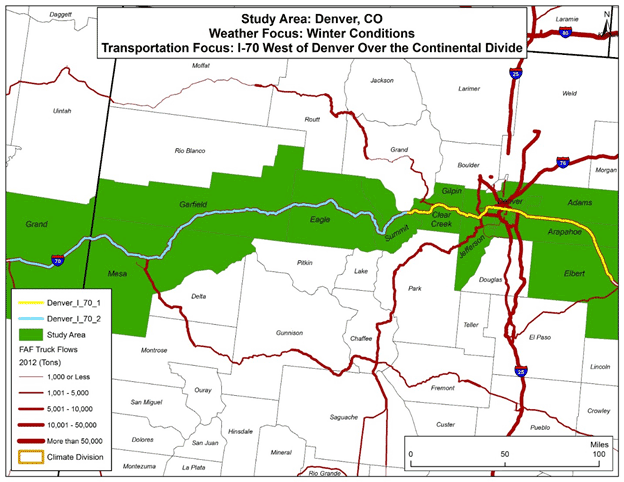
To select the final study areas, the project team further investigated the recommended study areas in light of available data, and produced maps of each study area detailing Interstates, major arterials, county and State boundaries, major cities, and climate divisions. Interstates were depicted as graduated truck flows using Freight Analysis Framework Version 3.5 (FAF3.5) data. Figure 2 provides an example of these maps.
Figure 2. Map. Recommended Denver, Colorado study area and transportation focus.
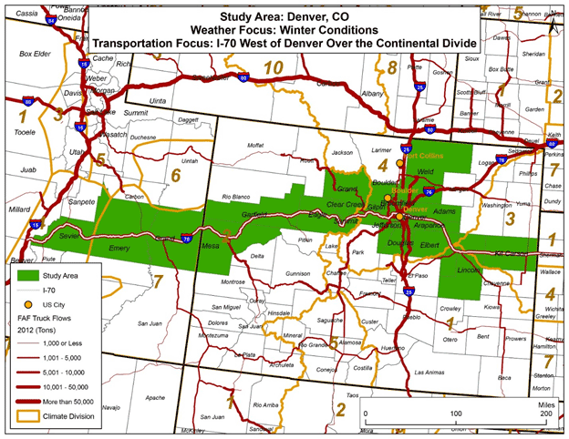
(Source: Cambridge Systematics, Inc.)
The project team used the study area maps to define a more practical and precise transportation focus for each final study area. To broaden the project’s analysis of winter weather—suspected to have a large impact on freight—the reserve study area of Salt Lake City, Utah was included in the final set of study areas. Lexington, Kentucky and Pittsburgh, Pennsylvania, which had both been under consideration during earlier stages, were also added back in to the final set of study areas because both experience a broad range of weather events, including winter weather, and contain mountainous regions. The reserve study area of Birmingham, Alabama, was not included in the final set as its weather profile was very similar to that of Atlanta, Georgia. Additionally, the proposed control study area of Phoenix, Arizona was not included in the final analysis because it had only a small number of recorded weather events. The list of the final 13 study areas and transportation focuses are shown in table 4. It is important to note that these routes stretch significant distances. Therefore, even in this more focused regional analysis, weather events vary within the study areas. The impacts of this variation on the interpretation of results—as well as efforts to account for this variation in the methodology by examining each study area by county—will be further discussed in the following sections.
Table 4. Final list of study corridors.
| Study Area |
Transportation Focus |
| Atlanta, Georgia |
The I-285 Beltway. |
| Chicago, Illinois |
I-57 from I-94 to the north and the Kankakee/Iroquois county line to the south. |
| Columbus, Ohio |
I-70 from I-75 to the west and the Licking/Muskingum county line to the east. |
| Denver, Colorado |
I-70 from SR-191 in Grand, Utah to the east and the Elbert/Lincoln county line to the east. |
| Lake Tahoe, California |
I-80 from I-5 to the west and the California/Nevada border to the east. |
| Lexington, Kentucky |
I-64 from I-265 to the west and the Bath/Rowan county line to the east. |
| Newark, New Jersey |
I-78 from I-476 to the east and I‑95 to the west. |
| Oklahoma City, Oklahoma |
I-35 from I-44 to the north and U.S. 70 to the south. |
| Pittsburgh, Pennsylvania |
I-79 from I-80 to the north and the Pennsylvania/West Virginia border to the south. |
| Raleigh, North Carolina |
I-40 from the Davie/Forsyth county line to the east and the Johnston/Sampson county line to the west. |
| Rapid City, South Dakota |
I-90 from the Wyoming/South Dakota State line to the west and SR-45 (Kimball) to the east. |
| Salt Lake City, Utah |
I-80 from the Nevada/Utah border to the west and the Utah/Wyoming border to the east. |
| Seattle, Washington |
I-90 from I-5 to the west and I-82 to the east. |
In addition to the map for the Denver, Colorado study area (figure 2, above), maps for the remaining 12 final study areas are included below as figures 3 through 14.
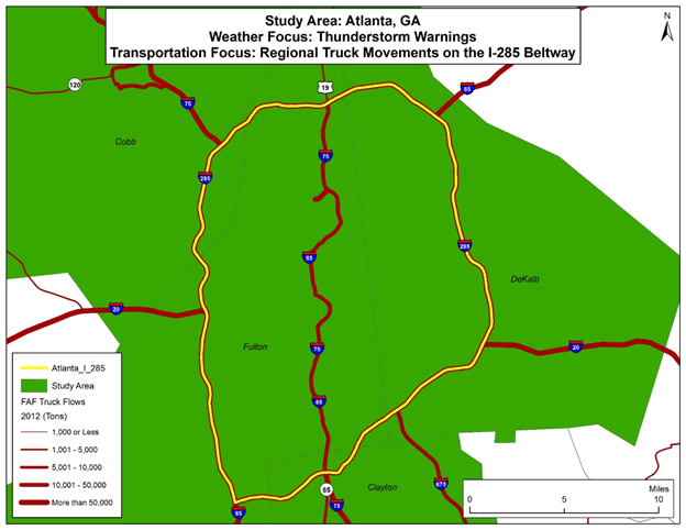
Figure 3. Map. Atlanta, Georgia study area and transportation focus.
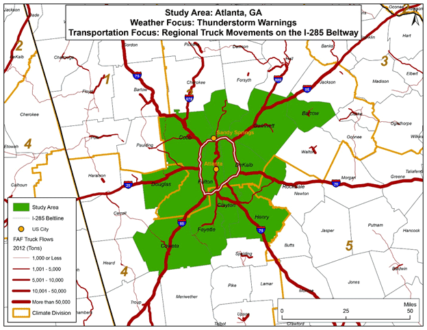
(Source: Cambridge Systematics, Inc.)
Figure 4. Map. Chicago, Illinois study area and transportation focus.
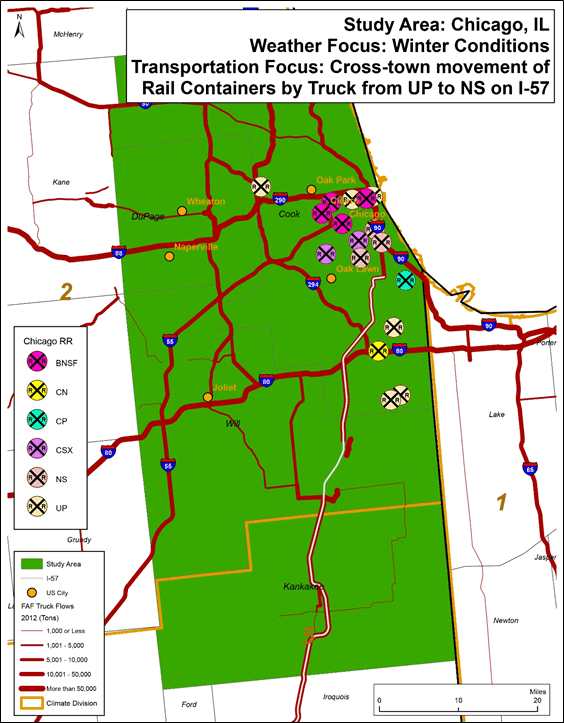
(Source: Cambridge Systematics, Inc.)
Figure 5. Map. Columbus, Ohio study area and transportation focus.
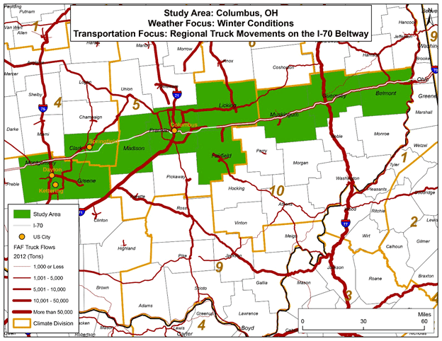
(Source: Cambridge Systematics, Inc.)
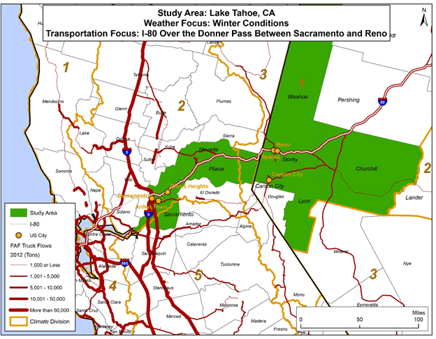
Figure 6. Map. Lake Tahoe, California study area and transportation focus.
(Source: Cambridge Systematics, Inc.)
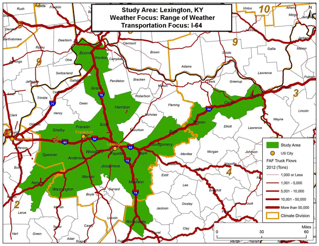
Figure 7. Map. Lexington, Kentucky study area and transportation focus.
(Source: Cambridge Systematics, Inc.)
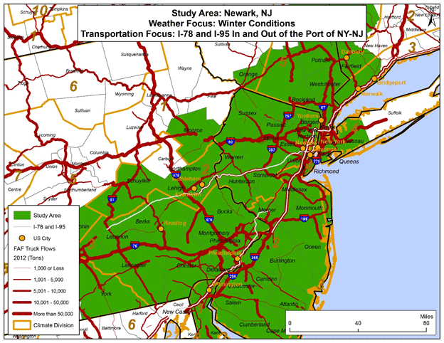
Figure 8. Map. Newark, New Jersey study area and transportation focus.
(Source: Cambridge Systematics, Inc.)
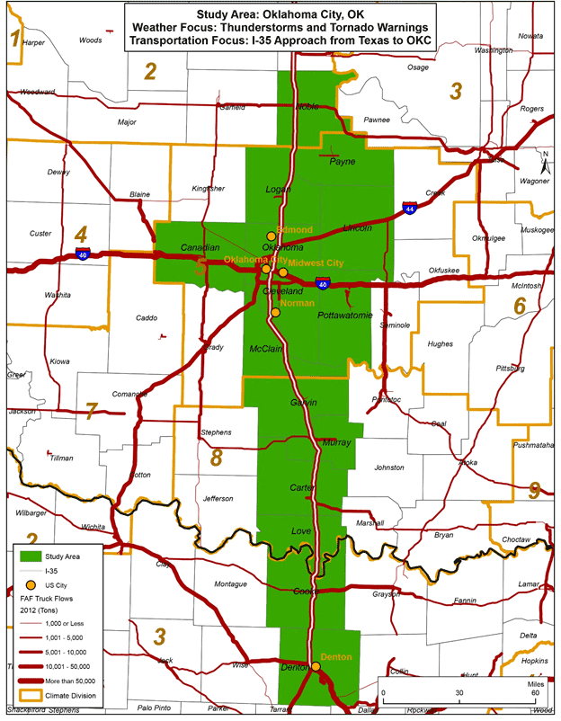
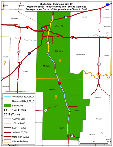
Figure 9. Map. Oklahoma City, Oklahoma study area and transportation focus.
(Source: Cambridge Systematics, Inc.)
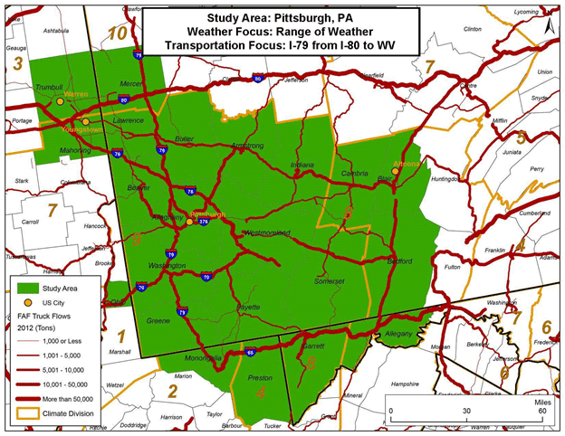
Figure 10. Map. Pittsburgh, Pennsylvania study area and transportation focus.
(Source: Cambridge Systematics, Inc.)
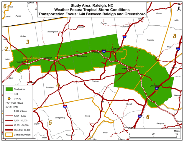
Figure 11. Map. Raleigh, North Carolina study area and transportation focus.
(Source: Cambridge Systematics, Inc.)
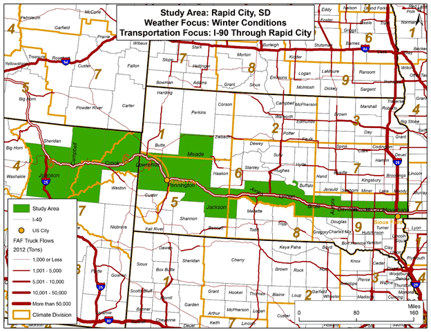
Figure 12. Map. Rapid City, South Dakota study area and transportation focus.
(Source: Cambridge Systematics, Inc.)
Figure 13. Map. Salt Lake City, Utah study area and transportation focus.

(Source: Cambridge Systematics, Inc.)
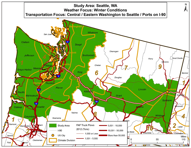
Figure 14. Map. Seattle, Washington study area and transportation focus.
(Source: Cambridge Systematics, Inc.)
Final Data Processing Methodology
Test Cases
Given the final set of study areas, the project team chose three study areas of varying complexity (Atlanta, Georgia; Oklahoma City, Oklahoma; and Denver, Colorado) to test a methodology for processing data on travel-time, weather, and freight. The final transportation focus for each of these three study areas are shown in detail in figures 15, 16, and 17.
Figure 15. Map. Final Atlanta, Georgia transportation focus.
(Source: Cambridge Systematics, Inc.)
Figure 6. Map. Final Oklahoma City, Oklahoma transportation focus.
(Source: Cambridge Systematics, Inc.)
Figure 17. Map. Final Denver, Colorado transportation focus.
(Source: Cambridge Systematics, Inc.)
After working with the three test cases, the project team developed a final data processing methodology, described in detail in the section below. While the team took into consideration all data sources discussed in an earlier technical memo, the final methodology uses only three national data sets: 1) the National Performance Management Research Data Set (NPMRDS) provided by HERE's download service for travel-time data, 2) the National Oceanic and Atmospheric Administration's (NOAA) Storm Events Database for weather data, and 3) Federal Highway Administration's (FHWA) Freight Analysis Framework Version 3.5 (FAF3.5) database for freight data. These selections allow consistent data comparisons between study areas, as well as within individual study areas over time. More information on each of these data sets can be found at the following Web sites:
- NPMRDS via HERE.
- NOAA's Storm Events Database.
- FAF3.5.
One of the objectives of the study was to use the most recent data sets available for the analysis in order to capture the most recent traffic speeds, weather events, and freight flow data. The reporting format of HERE data changed significantly in the middle of 2013. In order to maintain consistency the analysis period began with the HERE data in July 2013 and extended to August 2014. While both the HERE and Storm Events database were current through August 2014, the FAF data was only current through 2012. Given this, FTR Transportation Intelligence models were employed to generate economic impacts for 2015 (the year of the analysis) from this data.
Travel-Time Data: National Performance Management Research Data Set/HERE
The NPMRDS downloaded from HERE's online service (referred to hereafter as "HERE" data) provides data on average travel times for all vehicles, average travel times for passenger vehicles, and average travel times for freight vehicles along the National Highway System (NHS), which carries a large proportion of freight truck traffic.
This data set presented several challenges in adapting the data to this research application. First, the basic unit of roadway in the HERE data is called the Traffic Management Code (TMC). These very small road segments are intended to be used by local Traffic Management Centers, in which trained human operators process traffic and roadway data to implement incident management plans and Intelligent Transportation Systems (ITS) technology. TMCs generally do not map well to other roadway identification codes and thus need to be combined in order to match the data for other roadway segments, such as those used in the FAF data.
Moreover, the TMC data itself is presented in 5-minute "epochs" for each State and each date. The epoch only appears in the data set if a vehicle (of any type) was on the roadway during that epoch. This means that there is an inconsistent number of records per TMC per date. Because the length of each TMC is known, the project team converted average travel times for all vehicles, passenger vehicles, and freight vehicles into miles per hour for each epoch.
Another common issue is that HERE data is actually comprised of two different data sources: it uses NPMRDS data for passenger vehicles but relies on American Transportation Research Institute (ATRI) data for freight vehicles. As a result there were many instances in which truck speeds were greater than passenger vehicle speeds, but the travel time for all vehicles was either greater or less than both the truck and passenger vehicle travel times. This is at least results from the fact that the truck-only travel-time data was oftentimes based on small samples. The team, therefore, did not have confidence in the truck-only data and decided to use the travel-time observations for all vehicles instead. The travel-time observations for all vehicles were based on larger sample sizes and, thus, were more stable. Since, in most cases, truck speeds are not likely to vary significantly from those of general traffic, the team felt that it was reasonable to make the assumption that truck speeds would be the same as general traffic.
HERE provided the data as .csv files for each month by year and by State. Within each file, there were two linkage files, one called "Monthly_Static_File.csv" and a Microsoft Access database called NPMRDS.mdb. NPMRDS.mdb contained a table that was designed to connect to each month of data in order to translate the epochs into geographical information system (GIS) shapefiles. Because the .csv files were too large for most general software, including Esri ArcGIS and Microsoft Access (which was what HERE’s user guide recommended), the project team decided to pull the data into Microsoft Access by linking it rather than importing it. Towards this end, all file and field naming conventions were standardized so that one set of queries and one macro could access the needed data. The output of this process was automatically assembled in a new set of final databases, which was also linked to save space.
Weather Data: National Oceanic and Atmospheric Administration's Storm Events Database and National Land Data Assimilation Systems
The project team used the NOAA's Storm Events Database (hereafter the "storm database") and the National Land Data Assimilation Systems (NLDAS) as its primary sources of data on weather events, including event type, State, county, date, time (by hour of the day), and magnitude (e.g., inches of snow per hour). Since weather does not impact traffic most of the time, it was necessary to strategically identify and correlate bad weather events to the travel-time and freight data. The assumption here is that, if weather has any significant impact on traffic, it will occur during relatively major weather events. To this end, all major weather events in the 13 study areas were identified by time and place using the storm database.
The Storm Events Database documents the occurrence of storms and other weather phenomena having significant intensity to cause loss of life, property damage, and/or disruption to commerce, which is the definition of a "major" weather event used in this study. It also documents rare or unusual weather phenomena, such as snow flurries in South Florida, and significant meteorological events, such as record maximum and minimum temperatures or precipitation that occur in connection with another event. The database currently contains information from January 1950 to June 2015; however, due to changes in data collection and processing over time there are unique periods of record available depending on the data type. The National Climatic Data Center (NCDC) has performed data reformatting and standardization of weather event types, but has not changed any values for data on locations, fatalities, injuries, damages, etc. Table 5 on the following page displays the range of weather event types available in the storm database.
The NLDAS data set—which assimilates data from a large range of sources—was then used in the test phase for the actual correlation of detailed weather data gridded to highway segments, specifically for the identified major weather events to the travel-time and freight data. (The NLDAS is model gridded data that assimilates data from various sources, such as Meteorological Assimilation Data Ingest System (MADIS), Road Weather Information System (RWIS), Automated Surface Observing System (ASOS), and mesonets. The analysis data, not the forecast projection, were used. Detailed data for 8-kilometer grids matched to highway segments.) While this provided more precise location of events, the data processing requirements to use this information for all 13 case studies could not be met within project budget and schedule. Both the size of database and the use of different GIS projection systems made it difficult to match NLDAS data to the HERE and FAF databases.
As a result, the Storm Events Database was used as the basis for identifying weather conditions. This allowed major events to be located by time, by county, and by climate region boundary. (Records in the storm database were organized by county and/or by zone. A zone might be comprised of several counties, or it might refer to a local area designated by the National Weather Service. Such inconsistencies made it at times difficult to locate the relevant records for this project's study area and required manual look-up to match the climate zone and correct county.) While this methodology did not necessarily locate a weather event exactly over a roadway at a specific time (it only associates weather events reported in a given county with the roadways in that same county), it provided a good proxy for the impact of weather events given the currently available data. Since these weather events were classified as major events with relatively wide geographic impact in most cases, it is reasonable to assume that most major study area roadways within the same county as the weather event in question were exposed to the weather event. It is important to note, that the size of the county will influence the results. In general urban counties are smaller in size than rural counties. It is, therefore, more likely that there will be a better match between the reported weather and actual roadway conditions on the more heavily traveled urban roads. Further, actual roadway impacts were inferred from exposure and proximity to weather events; this series of assumptions is important to bear in mind in interpreting the findings of this analysis. It should, however, be noted that the HERE data was compressed from 5-minute raw data into hourly time periods, which increases the likelihood that, over the course of an hour, the weather events in question occurred over the study area roadways.
Table 5. Weather event types included in National Oceanic and Atmospheric Administration’s Storm Events Database.
| Astronomical Low-Tide |
| Avalanche |
| Blizzard |
| Coastal Flood |
| Cold/Wind Chill |
| Debris Flow |
| Dense Fog |
| Dense Smoke |
| Drought |
| Dust Devil |
| Dust Storm |
| Excessive heat |
| Extreme Cold/Wind Chill |
| Flash Flood |
| Flood |
| Frost/Freeze |
| Funnel Cloud |
| Freezing Fog |
| Hail |
| Heat |
| Heavy Rain |
| Heavy Snow |
| High Surf |
| High Wind |
| Hurricane (Typhoon) |
| Ice Storm |
| Lake-Effect Snow |
| Lakeshore Flood |
| Lightning |
| Marine Hail |
| Marine High Wind |
| Marine Strong Wind |
| Marine Thunderstorm Wind |
| Rip Current |
| Seiche |
| Sleet |
| Storm Surge/Tide |
| Strong Wind |
| Thunderstorm Wind |
| Tornado |
| Tropical Depression |
| Tropical Storm |
| Tsunami |
| Volcanic Ash |
| Waterspout |
| Wildfire |
| Winter Storm |
| Winter Weather |
Many of the weather event types presented in table 5 are not applicable to the study areas examined in this project. The entire storm database was downloaded and compiled into a Microsoft Access database in an effort to be comprehensive. For the final analysis, however, only the 25 most relevant weather event types, shown in table 6 below, were analyzed. The notable missing weather event type from both the storm database and the final analysis is light rain. This is because, if only light rain occurred, the event did not meet the criteria for inclusion in the storm events database. However, many of the rain events in the database probably included a period of light rain toward the beginning or end of the storm.
Table 6. The 25 weather event types included in the final analysis.
| Avalanche |
| Blizzard |
| Cold/Wind Chill |
| Dense Fog |
| Excessive Heat |
| Extreme Cold/Wind Chill |
| Flash Flood |
| Flood |
| Freezing Fog |
| Frost/Freeze |
| Funnel Cloud |
| Hail |
| Heat |
| Heavy Rain |
| Heavy Snow |
| High Wind |
| Ice Storm |
| Lake-Effect Snow |
| Lightning |
| Strong Wind |
| Thunderstorm Wind |
| Tornado |
| Wildfire |
| Winter Storm |
| Winter Weather |
The project team processed the weather data to produce a final data set of all relevant records with State, county, date, time, weather event type, and magnitude. Since there were several instances in which multiple storm events were recorded in one day, the data remained organized by storm event and each storm event was given a unique identifier. Each storm event included the time four hours before and four hours after the recorded time of the storm event (t=0). Care was taken to ensure that storms crossing the midnight hour were coded as a single storm event. Finally, the processed data from the storm database was linked to the final HERE databases.
Freight Data: Freight Analysis Framework Version 3.5
The Federal Highway Administration's Freight Analysis Framework Version 3.5 (FAF3.5) provides estimates of tonnage, value, and domestic ton-miles by region of origin and destination. The project team selected the 2012 FAF3.5 data over the 2007 FAF3 data—which would have also allowed FAF estimates to be separated by commodity types—because the 2007 FAF3 data would have been outdated relative to the 2012 to 2014 weather and travel-time data used in this analysis.
The FAF3.5 data includes origin-destination tables that are delivered on a static roadway network. Under a separate contract Cambridge Systematics, Inc. developed an "assignable" network which allows future FAF origin-destination tables to be assigned to the roadways. For the analysis at hand, the FAF3.5 assigned network was used and matched to the HERE and Storm Event database. The following paragraph describes this process in more detail.
Using Esri ArcGIS 10.2, the FAF3.5 data was overlaid with HERE data linked to a shapefile. The FAF3.5 data was organized as FAF segments, which were typically much longer than the HERE data links and were loaded with daily 2012 truck tonnage in kilotons. FAF segments tended to start and end at interchanges because this is where trucks typically enter or exit the highway system. The process of matching FAF3.5 data to HERE data in ArcGIS was done manually. As is common with data from different sources, the FAF3.5 and HERE data sets did not use the same projected coordinate systems and so care was taken to correct and match the projections of both files. Further, the FAF3.5 data is a centerline data set (one line used for all traffic) while the HERE data is bidirectional (two lines—one for each side of the highway). Since the raw FAF data includes tonnage and is bidirectional, conversion of tonnage to truck volumes was required as well as assignment based on direction. The assignment of FAF version 3.5's 2012 Origin-Destination table to an assignable highway network was done by Cambridge Systematics using methods that it developed for FHWA. Additional adjustments were made to truck volumes during the weather index analysis, using data from the FTR freight model. Overall both the HERE and FAF3.5 data sets were robust and complete, except in a few rare cases when a record from one data set was missing or the data was null.
Once linked, The FAF3.5 data was checked for consistency. As a final step, the project team added pertinent information such as county and study area name to the FAF3.5 records. The data set was then linked to the final databases.
Final Databases
For the final databases, each of the three data sets was carefully combined so they produced data by storm event. Storms were county-based, in that storm event reports are broken down by county, and, in some cases, by weather zone in the database. Reports of storm events are received from counties and other sources and combined with National Weather Service (NWS) data. Given this method of reporting, roadway segments in a given county were assumed to have experienced all storms associated with that county. Real-world experience dictates that this is not always the case, especially for certain types of storms. However, for larger weather events that typically impact traffic, such as winter storms, it is likely that a large proportion of the county experienced the storm and so it has been assumed that the entire county experienced the storm. The final data set included the time four hours before and four hours after each storm, an identifier for these records, an identifier for the storm event record, a weekday flag, a holiday flag, county, study area, and total storm duration. Since the HERE data contained a full set of the records for the 14-month analysis period, periods with no storm event could be identified and matched with storm event periods to determine the weather delay index. The availability of 24-hour data allowed flexibility in identifying the time periods when recurring congestion impacted the subject roadways. Periods with and without storm events could be matched by day of week and time of day.