Guidance on Using Traffic Management Centers for Work Zone Management
CHAPTER 2. GUIDANCE FOR TMC RESOURCES SUPPORTING WORK ZONES
This section presents guidance for using TMC resources to support work zone planning and operations in the form of a set of strategies to be considered throughout the four stages of the work zone design, operations, and evaluation. Each recommended strategy is supported by one or more examples of successful implementation.
It is important to note that there are many areas within a DOT that will benefit from utilizing the strategies included in the sections below. Each DOT is organized differently and has expertise pulled from many different areas; however, the following groups within transportation agencies will benefit from the awareness and use of TMC resources.
- Construction and Maintenance staff;
- Project Planning/Design staff;
- Project Engineer/Manager;
- TMC Managers/Operators;
- Incident Response Personnel; and
- Traveler Information Coordinator.
In additional to staff within a transportation agency benefiting from the strategies the traveling public also benefits from the many DOT groups working with the TMC. Utilizing TMC resources provides another component when analyzing a work zone to improve safety and reduce overall delay for travelers.
2.1 WORK ZONE STAGE 1: PROJECT DEVELOPMENT – PLANNING AND DESIGN
Stage 1 of the work zone process occurs when the road work project is being planned and designed, and is prior to the detailed design of the work zone that will support the project. Two strategies are presented below to utilize TMC resources during this stage in the overall work zone process:
- Strategy #1: Using TMC resources to Coordinate Road Work Projects
- Strategy #2: Using TMC Resources to Support Preliminary Work Zone Impact Analyses
The remainder of Section 2.1 presents details of these strategies and examples of use.
2.1.1 Strategy #1: Using TMC Resources to Coordinate Road Work Projects
When two or more work zones are in operation simultaneously on the same route or adjacent parallel routes, the impacts on drivers are often increased. Coordination of road work projects considers other planned work zones and minimizes the impacts, either by adjusting the schedule or capacity restrictions of the work zone. Strategy #1 is using TMC resources to coordinate road work projects during the planning and design of the construction or maintenance projects. Three specific strategies for using TMC resources (1A, 1B, and 1C) are identified in Table 2, together with hyperlinks to the descriptions of each specific strategy and to the examples of use.
Table 2. Strategy #1 – Guidance and Examples of Strategy Use
| Strategy #1: Using Traffic Management Center (TMC) Resources to Coordinate Road Work
Projects |
|
Guidance |
Examples of Strategy Use |
| Strategy 1A |
|
|
| Strategy 1B |
Involve TMC staff in the planning of road work projects from the onset to enable TMC staff to understand the planned projects and impacts for all areas served by the TMC and therefore contribute to regional
mobility planning. |
|
| Strategy 1C |
Organize annual meetings with TMC staff from neighboring
jurisdictions (states, cities, counties) to discuss upcoming road work plans. |
|
Table 3. Strategy 1A – Description, Benefits, and Implementation Steps
Work Zone Stage 1: Project Development – Planning and
Design
Strategy #1: Using Traffic Management Center (TMC) Resources to Coordinate Road Work
Projects |
|
Strategy 1A |
Share access to TMC tools used to record ongoing and
planned projects, analyze corridor performance, and predict road user costs
with all individuals involved in the road work planning process to support
the coordination of road work projects. |
|
Description |
Each state Department of Transportation (DOT) operates some form of a traveler
information system. The majority of DOTs use some type of a Road Condition
Reporting System as the back-end data fusion engine that supplies the
information that is displayed over phone, web, social media, and other traveler
information dissemination mediums. A Road Condition Reporting System is most
often a web-based tool that enables entry of information from DOT staff
throughout the state, and often includes an automated data ingest from
multiple systems. It is very common that the Road Condition Reporting System is ‘owned’ and operated by one of the TMCs in the state. Therefore, a Road
Condition Reporting System is considered a TMC resource, common to many
states. In order to disseminate information describing current and planned
road work through the traveler information systems, most DOT staff enter planned
road work projects into their Road Condition Reporting System, often for one
or more years into the future. Therefore, in addition to supporting traveler
information, the Road Condition Reporting System is also an effective
management tool to enable road work project planners to be aware of other
projects that may be planned by other groups within the DOT. This strategy
is to share access to TMC tools to record ongoing and planned projects,
analyze corridor performance, and predict road user costs with all
individuals in the road work planning process to help in coordinating
projects during the
Share access to TMC tools used to record ongoing and
planned road work projects, analyze corridor performance, and predict road
user costs with all individuals involved in the road work planning process to
support the coordination of road work projects.
Examples of tools and resources include: Road Condition
Reporting Systems, archived probe data, and automated analytical tools such
as the Regional Integrated Transportation Information System (RITIS)planning phase, and avoiding overlapping projects.
Many states also operate or have access to automated
analytical tools that fuse together data from multiple sources and perform
analytical analyses to report predicted or actual historic performance
measures. The Regional Integrated Transportation Information System (RITIS) is
one example of an automated analytical tool used by many DOTs. With RITIS,
it is possible to view predictions for impacts that work zones will have on
the overall network considering other planned road work projects and
historical data describing traffic volumes. |
|
Anticipated Benefit(s) |
Increased awareness of other construction and maintenance
projects at a time when the road work project is still being planned,
enabling adjustments to promote coordination over time and space |
|
Implementation Steps |
- Identify the individual within the DOT responsible for
managing the Road Condition Reporting System or Transportation Information
System.
- Request user access and training for individuals involved
in work zone planning (typically access can be granted on a ‘view-only’ for
individuals who do not enter events but need to view events).
- Encourage Project Planning/Design Staff to log-in
frequently and view other road work plans, and to enter descriptions of road
work they are planning, in accordance with the Road Condition Reporting
System entry guidelines.
|
Table 4. Strategy 1A – Example of Department of Transportation (DOT) Use
| Strategy 1A |
Share access to Traffic Management Center (TMC) tools used to record ongoing and
planned projects, analyze corridor performance, and predict road user costs
with all individuals involved in the road work planning process to support
the coordination of road work projects. |
|
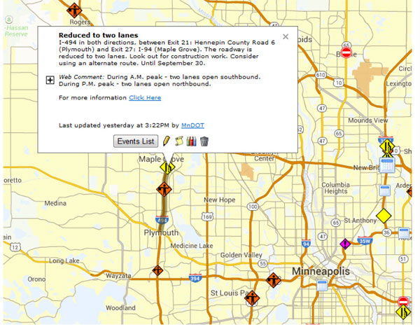
1A Example 1 – Minnesota Department of Transportation (DOT) |
The Minnesota DOT operates a statewide road condition
reporting system (Condition Acquisition and Reporting System (CARS)). Planned road work events are entered into CARS by the appropriate department
within Minnesota DOT. Regional Transportation Management Center (RTMC)
operators located in St. Paul, Minnesota and other DOT staff with access to
the system are able to view and access current and future work zone
information (e.g., location, description of work, lane restrictions) through
CARS. The information entered is also posted to the public 511 traveler
information website.
The schedule for significant road work projects (e.g., long
duration construction projects) within Minnesota DOT are typically well known
throughout the organization, and conflicts with other projects are less
likely since DOT staff are aware of these projects and coordinate with other
projects accordingly.
However, some maintenance and construction road work projects
that may have shorter durations or less significant impacts to traffic may be
less known throughout Minnesota DOT as they are planned. When this occurs,
for example, two or more lane closures could occur on parallel routes
simultaneously causing additional delay even if the information has been
entered into CARS. It is critical CARS is reviewed by RTMC staff weekly as
one final check, as well as by work zone planning staff to address any
conflicts that may occur.
Review of events entered into CARS has proven to avoid
simultaneous work zones occurring on parallel routes. RTMC operators are
able to view and access current and future work zone information (e.g., location,
description of work, lane restrictions) through CARS as shown below. It is
important to note that RTMC operators also have access to the CARS entry
interface to view and enter events. The screenshot shown below shows how
RTMC operators and the public can search for future road work project
information and the details of construction information that is provided.
|
|
1A Example 2 – Michigan DOT |
Michigan DOT determines 10 minutes of additional work zone
delay as a significant road work project and requires a Transportation
Management Plan to be developed anytime the work zone delay exceeds this
threshold. The estimated values for user delay costs are computed using
the Construction Congestion Cost (C03) Software. The CO3 values are then
compared to field measured speeds and Regional Integrated Transportation
Information System (RITIS) is used to analyze and determine how closely the
predicted values are with actual field results. This method has allowed
Michigan DOT to improve work zone designs and is allowing Michigan DOT to
more accurately predict work zone delays.
This improvement in forecasting of work zone delay helps Michigan
DOT select an appropriate design for the location and roadway, in-turn
improving the overall design process by having a better understanding of how
different Maintenance of Traffic methods will affect the roadway network as a
whole, not just at the project level. |
Table 5. Strategy 1B – Description, Benefits, and Implementation Steps
Work Zone Stage 1: Project Development – Planning and
Design
Strategy #1: Using Traffic Management Center (TMC) Resources to Coordinate Road Work
Projects |
|
Strategy 1B |
Involve TMC staff in the planning of road work projects
from the onset to enable TMC staff to understand the planned projects and
impacts for all areas served by the TMC, and therefore contribute to
regional mobility planning. |
|
Description |
TMCs often support operations of multiple geographic or
institutional regions within a Department of Transportation (DOT). Similarly, TMCs often communicate and
coordinate with TMCs in neighboring states. This strategy is to involve TMC
staff early in the project development process to allow the TMC to contribute
a regional perspective on other planned road work and events. |
|
Anticipated Benefit(s) |
A regional perspective on other road work projects and
events will be considered during the project development period to minimize
agency/user costs |
|
Implementation Steps |
- Identify the TMC staff most appropriate to be involved in
coordination of road work projects during project development.
- Arrange a meeting structure to engage TMC staff with Project
Planning/Design Staff (roughly 3-4 times per year).
|
Table 6. Strategy 1B – Examples of Department of Transportation (DOT) Use
| Strategy 1B |
Involve Traffic Management Center (TMC) staff in the planning of road work projects
from the onset to enable TMC staff to understand the planned projects and
impacts for all areas served by the TMC and therefore contribute to regional
mobility planning. |
|
1B Example 1 – Minnesota Department of Transportation (DOT) |
|
Minnesota DOT road work projects in the St.
Paul/Minneapolis Metro Area are divided into several areas. A resident
engineer is assigned to each of these areas and all of areas work together to
coordinate large road work projects that may affect a neighboring areas and
identify potential conflicts across a region. The Minnesota DOT Regional
Transportation Management Center (RTMC) is made aware by the resident
engineers of the initial planning and schedule for road work projects. This
coordination provides RTMC staff an opportunity to provide input on the
project based on observations of similar road work projects and resulting
impacts and an increased awareness of future projects. |
|
1B Example 2 – Oregon DOT |
For road work projects in Oregon, the Oregon DOT
implements a regional construction coordination team that is led by a
construction engineer and includes area managers, project managers as well as
Traffic Management Operations Center managers and staff. The purpose of the
team is to coordinate work affecting critical route pairs to ensure that key
freight routes remain within recommended delay thresholds.
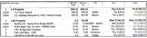
A region mobility schedule is produced and shared among
the regions at the Oregon DOT to coordinate road work projects as shown in Figure 2. For example, the schedule includes the location of the project and start
and end dates of the project. Coordinating regional projects with staff from
affected geographical regions provides input and expertise to enhance
coordination and identify the best options to complete the work while
maintaining unrestricted freight routes
|
Table 7. Strategy 1C – Description, Benefits, and Implementation Steps
Work Zone Stage 1: Project Development – Planning and
Design
Strategy #1: Using Traffic Management Center (TMC) Resources to Coordinate Road Work
Projects |
|
Strategy 1C |
Organize annual meetings with TMC staff from neighboring
jurisdictions (states, cities, counties) to discuss upcoming road work
plans. |
|
Description |
Coordination of road work projects expands beyond state
boundaries, as the impacts of simultaneous road work on parallel or
contiguous routes are often experienced across areas that extend into
multiple jurisdictions (e.g., neighboring states, city or county routes). This
strategy involves project planning/design staff and TMC staff from contiguous
states meeting annually to review planned road work activities in order to
understand any potential conflicts and/or opportunities to minimize impacts. While it may not be possible for the impacted jurisdictions to adjust their
work zone schedules to coordinate with all affected jurisdictions, the
understanding gained in these annual meetings can support each entity’s work
zone planning process. |
|
Anticipated Benefit(s) |
- Reduced situations where work zones in two or more
neighboring states or city/county jurisdictions occur simultaneously on
contiguous road segments
- Minimized impacts of work zones on contiguous road
segments through information dissemination or other similar strategies
|
|
Implementation Steps |
- Identify a core set of agencies (e.g., neighboring states,
local counties or municipalities) that conduct road work projects with a
likelihood of conflicting with the other agencies in the group.
- Organize a process of meeting once per year, typically in
the winter after the road work projects are planned. Note: Feedback from the
examples in the following table suggest that keeping the same date each year
helps all attendees plan and prepare for the meeting.
- Define a structure that allows each participating agency to
present all planned road work projects in the time allowed (i.e., encourage high-level
summaries and avoid too much detail).
- Determine if supporting resources are needed (e.g., a
web-based mapping tool to display road work projects for all to view) and
identify a source for these (e.g., internal developed tool, Google maps,
etc.).
|
Table 8. Strategy 1C – Examples of Department of Transportation (DOT) Use
| Strategy 1C |
Organize annual meetings with Traffic Management Center (TMC) staff from neighboring
jurisdictions (states, cities, counties) to discuss upcoming road work
plans. |
|
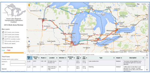
1C Example 1 – Great Lakes
Regional Transportation Operations Coalition (GLRTOC) |
Members of the Great Lakes Regional Transportation Operations Coalition (GLRTOC) include the
Chicago Skyway/Indiana Toll Road, Illinois Department of Transportation (DOT), Indiana DOT, Michigan DOT,
Ministry of Transportation Ontario, Minnesota DOT, and Wisconsin DOT. The
focus of the GLRTOC is to improve cross-regional transportation operations in
support of regional economic competitiveness and improved quality of life. Representatives from the Chicago region (including Illinois DOT, City of
Chicago, and local counties) have for many years held annual meetings to
review road work projects for the upcoming year. When GLRTOC was initiated,
the members suggested coordinating an annual meeting in conjunction with the
meeting already established by the Chicago region. During the meeting each
GLRTOC member that includes TMC staff and/or managers highlight upcoming road
work projects that may have an impact on a neighboring agency. GLRTOC has
developed an online Geographic Information Systems-based mapping system with
an interface that enables multiple agencies to enter planned roadwork (see Figure 3). The tool displays major roadwork events as an internal tool (not accessed
by the traveling public) to assist in work zone coordination across borders
and throughout individual states. This tool is updated prior to an annual
meeting that is held among that GLRTOC states and is displayed as individual road
work projects are discussed.
Figure 3. Map/Chart. 2013 Great Lakes Regional Transportation Operations Coalition Online Work Zone Map to Identify Impacts to Neighboring States
Source: http://www.glrtoc.org/workzones/
|
|
1C Example 2 – Transportation
Operations Coordinating Committee (TRANSCOM) |
TRANSCOM is a coalition of 16 public safety agencies in
the New York, New Jersey, and Connecticut metropolitan region. TRANSCOM’s construction
coordination efforts hinge on its construction coordination database and an
annual construction meeting in which the member agencies discuss upcoming road
work projects. There are two annual meetings in March of each year, one each
for the southern and northern parts of the region. Some of the major
agencies (16 transportation agencies in the New York, New Jersey and
Connecticut Metropolitan region) in the center of the region attend both. In
preparation for the meeting, in December TRANSCOM sends the member agencies the
database of road work projects and asks them to update it with their projects
for the coming year. Projects that are planned for more than a year out may
be included if they are anticipated to have significant impacts. Utility
projects are not included as part of this effort, however, information is
collected from member agencies on special events. Special event information
is not stored in the construction database, but it is shared with all members
at the construction coordination meeting.
After collecting inputs, TRANSCOM produces a report
listing all of the upcoming projects and potential conflicts and a special
events calendar. The report and special events calendar are sent out to the
member agencies two weeks prior to the annual meeting. The projects and
special events are then all discussed among the members at the annual
meeting.
During the annual meeting, agencies are given the
opportunity to ask questions of each other in order to learn more about the
projects and potential impacts. Police and transit member agencies attend,
as well. The agencies also begin to work together at this meeting to
identify hotspots and formulate plans for how to best handle and mitigate
impacts. Follow-up meetings between the appropriate agencies are typically
held to identify impacts mitigation strategies and how to handle traffic
management for those projects that potentially have large regional impacts.
Member agencies have indicated that they find the annual
meeting valuable because it is a meeting with a tangible outcome — it allows
agencies to become aware of and begin to proactively mitigate work zone
impacts and increase customer satisfaction, thereby reducing the daily
challenges of managing multiple roadway construction projects. They also
enjoy coming to the meeting as it gives them a chance to network with their
peers across the region.
Following each annual meeting, TRANSCOM provides a summary
of the discussion to the member agencies. For the projects that could potentially
have greater regional impacts, TRANSCOM continues to meet with the agencies
involved on a regular basis. For some projects, monthly face-to-face
meetings are held, while others might involve weekly phone calls and emails. These meetings enable TRANSCOM to monitor the projects and also provide
suggestions and guidance to the agencies impacted by the projects. Recommendations
provided by TRANSCOM may include scheduling changes, sequencing changes
(i.e., one agency works in one direction of the roadway while the other works
in the other direction), or timing changes (i.e., one agency works at night
while the other works during the day). Typically, the attendees discuss
coordination of road work projects during the meetings and formal agreements
do not need to be made among agencies, although written confirmation is often
produced to confirm the mutual understanding among the agencies. Source: https://ops.fhwa.dot.gov/wz/construction/crp/nynjctcasestudy/ |
2.1.2 Strategy #2: Using TMC Resources to Support Preliminary Work Zone Impact Analyses
Preliminary work zone impact analyses are useful for understanding the likely traveler delays and queues caused by the work zone that will exist while the road work project is performed. While the Transportation Management Plan (TMP) developed at a later stage in the work zone deployment process will include a more in-depth impact analysis, this stage helps DOTs understand the overall ‘big picture’ view of the expected impacts in order to support coordination with other projects and to consider innovative contracting or accelerated construction. Strategy #2 is using TMC resources to support preliminary work zone impact analyses. The specific strategies for using TMC resources (2A, 2B, and 2C) are identified in the table below, together with hyperlinks to the descriptions of each specific strategy and to the examples of use.
Table 9. Strategy 2 — Guidance and Examples of Strategy Use
| Strategy #2: Using Traffic Management Center (TMC) Resources to Support Preliminary
Work Zone Impact Analyses |
|---|
|
Guidance |
Examples of Strategy Use |
| Strategy 2A |
Using TMC data together with TMC performance management
tools, to conduct preliminary demand-to-capacity calculations for upcoming
road work projects |
|
| Strategy 2B |
Develop Traffic Operations Plans for large projects before
the Transportation Management Plan is developed and before final design, to
define the planned use of intelligent transportation system components and
maximize the input from the TMC. |
|
| Strategy 2C |
Using TMC resources to support innovative contracting or
accelerated construction considerations. |
|
Table 10. Strategy 2A – Description, Anticipated Benefits, and Implementation Steps
Work Zone Stage 1: Project Development – Planning and Design
Strategy #2: Using Traffic Management Center (TMC) Resources to Support Preliminary
Work Zone Impact Analyses |
|
Strategy 2A |
Using TMC data together with TMC performance management
tools, to conduct preliminary demand-to-capacity calculations for upcoming
road work projects |
|
Description |
TMCs typically assemble and store a wide variety of data
that can be valuable when performing demand-to-capacity calculations. For
example, volume, speed, and occupancy data are often collected by any number
of detectors, probes, and other mechanisms throughout the roadway network. Similarly,
TMCs often calculate seasonal travel patterns and time-of-day patterns. TMC
staff also will typically have some data describing the capacity of alternate
routes to the candidate work zone area. This strategy is to use TMC data, together
with performance measurement and management tools available to the TMCs (i.e.,
vendor products or in-house developed tools), to understand likely traffic
pattern changes, estimate demand through the work zone, and identify potential
impacts based on expected capacity restrictions due to the work zone.
During non-work zone periods, the highway capacity is
typically well understood by TMC staff, as is the traffic demand during
different periods such as AM and PM peaks. During the road work planning
stage, early estimates of capacity restrictions (e.g., lane shifts, lane
closures, road closures) are discussed. These capacity restrictions can be
combined with historic volume data to understand the likely ratio of volume-to-capacity,
and ultimately to predict delays, queues, or route diversions. |
|
Anticipated Benefit(s) |
- Early project planning understanding of the extent to
which road work projects are likely to cause volume-to-capacity ratios
greater than 1 to assist in road work planning
- Early project planning understanding to the extent to
which road work projects are likely to cause queues and delays to assist in
road work planning
|
| Implementation Steps |
- Once the location of the work zone is defined, Project
Planning/Design Staff request archived volume, occupancy, and speed data from
the TMC (or use TMC tools to access archived data).
- Request input from the TMC to understand any recent
capacity or demand changes that would affect how reliable historic volume
data is for projecting demand during the upcoming work zone period.
- Volume-to-capacity calculations may be done by hand,
spreadsheet, or by using tools. Determine if the current approach for
performing volume-to-capacity calculations is effective and efficient. If
not, consider developing or procuring a tool to assist this process.
- After performing demand-to-capacity calculations and
predicting queues and delay, request that the TMC staff review the results
and share their perspective.
|
Table 11. Strategy 2A – Examples of Department of Transportation (DOT) Use
|
Strategy
2A |
Using Traffic Management Center (TMC) data together with TMC performance management
tools, to conduct preliminary demand-to-capacity calculations for upcoming
road work projects. |
|
2A Example 1 – Iowa Department of Transportation (DOT) Traffic Data and the Lane Closure
Planning Tool |
Iowa DOT uses volume data together with a Lane Closure
Planning Tool (LCP Tool) to perform preliminary estimates of the traffic
level of service expected during road work projects to provide an early
understanding of the likely impacts of capacity restrictions. Volume data is
collected from permanent Automatic Traffic Recorder (ATR) data and
supplemented by data from the Iowa statewide Transportation Operations
Center. The LCP Tool performs calculations and prepares graphs for
analysis. For example, a graph may display hourly volumes showing impacts if
a two lane road is temporarily modified to one lane. The LCP Tool is a web-based
program, and is used internally by Iowa DOT for work zone planning. However,
it is anticipated that additional data (e.g., sensor data) and more users
will be added in the future.
Figure 4. Map/Graph. Iowa Department of Transportation (DOT) Lane Closure Planning Tool
|
|
2A Example 2 – New Jersey DOT |
|
An intensive study was conducted at the New Jersey DOT to
analyze the impacts of a large road work project on the Pulaski
Skyway. A six-year project plan was reviewed, as well as a two-year
project plan. After a detailed analysis of alternate routes was conducted to
establish travel times and detours, a two-year project plan was selected
prior to the Transportation Management Plan development process. The
Regional Integrated Transportation Information System (RITIS) application was
used to conduct volume/capacity analysis. RITIS collects data provided by the
DOT (e.g., detector data, speed data), as well as from other sources, and
provides it in real-time and archived data formats. |
|
2A Example 3 – District of
Columbia DOT Work Zone Project Management System Use |
The District of Columbia DOT has developed a comprehensive
Work Zone Project Management System to facilitate the coordination of work
zone projects throughout DC for a five-year period using a predictive model
to determine potential impacts and identify related work zone conflicts. All
projects, including capital, utility, developer and special events, are
integrated into the graphical, web-based, software tool. The Work Zone
Project Management System includes three components — a Work Zone Tracking
Tool, a Traffic Analysis Tool, and a Citywide Transportation Management Plan.
Source: USDOT FHWA Coordinating Road Projects, website. |
Table 12. Strategy 2B – Description, Anticipated Benefits, and Implementation Steps
Work Zone Stage 1: Project Development – Planning and
Design
Strategy #2: Using Traffic Management Center (TMC) Resources to Support Preliminary
Work Zone Impact Analyses |
|
Strategy 2B |
Develop Traffic Operations Plans for large projects
before the Transportation Management Plan is developed and before final
design, to define the planned use of intelligent transportation system
components and maximize the input from the TMC. |
|
Description |
This strategy is to create Traffic Operations Plans (TOPs)
for large road work projects by including TMC staff early in the road work planning
process (prior to the Transportation Management Plan development process) and
utilizing TMC resources. TMC operators have the best knowledge of intelligent
transportation system field devices and TMC supporting tools and best
understand the capabilities of these to help maintain mobility and safety. This early planning can identify the extent to which existing field devices
will meet the work zone needs, and identify whether additional temporary
devices will be needed. Identifying these needs at this stage enables the
road work project to consider procuring these temporary devices as part of
the project procurement. |
|
Anticipated Benefit(s) |
- Early identification of planned operations strategies to
minimize work zone impacts
- Understanding of the temporary field devices that will be
needed to supplement permanent devices during the work zone at a stage where
these can be included in the road work project budget and procurement
|
|
Implementation Steps |
- Conduct a meeting with Project Planning/Design Staff and
TMC staff to discuss the timing, capacity restrictions expected, and duration
of the work zone.
- Invite TMC staff to describe their capabilities to
minimize impacts with existing TMC resources, any losses to TMC-controlled
field equipment, and their suggestions for temporary technologies to be
deployed in the work zone.
|
Table 13. Strategy 2B – Department of Transportation (DOT) Examples of Use
|
Strategy
2B |
Develop Traffic Operations Plans for large projects
before the Transportation Management Plan is developed and before final
design, to define the planned use of intelligent transportation system
components and maximize the input from the Traffic Management Center (TMC). |
|
2B Example 1 – Utah Department of Transportation (DOT) Preliminary Meetings for Large Construction Projects |
|
At the Utah DOT, operations of the Traffic Operations
Center (TOC) is a central function that supports 4 regions. TOC staff attend
meetings at the regional level for large road work projects. The expected
traffic impact from the road work project is discussed first during initial
planning meetings. The TOC then works with the project planning/design staff
to provide the traffic analysis for each of these large road work projects. |
Table 14. Strategy 2C –
Description, Anticipated Benefits, and Implementation Steps
Work Zone Stage 1: Project Development – Planning and
Design
Strategy #2: Using Traffic Management Center (TMC) Resources to Support Preliminary
Work Zone Impact Analyses |
|
Strategy 2C |
TMC resources support innovative contracting or
accelerated construction considerations. |
|
Description |
Accelerated construction and innovative contracting
approaches use various techniques and technologies to help reduce the
duration or costs of road work projects. Though useful, they often require a
decision early in the process when these approaches, such as design-build,
can still be selected. This strategy is using TMC data and performance
management tools to calculate expected road user costs of a road work project
so that accelerated construction or innovative contracting may be considered
at a stage when it is still possible to utilize these approaches. A critical
factor in the consideration of accelerated or innovative contracting is the
estimated road user costs per day that the work zone is in progress. Work
Zone road user costs are defined as “the additional costs borne by motorists
and the community at-large as a result of work zone activities”1, and typically include
user delay costs, vehicle operating costs, crash costs, and emissions costs. |
|
Anticipate Benefit(s) |
- Early understanding of whether or not the impacts and road
user costs of the work zone merit consideration of alternate contracting
approaches or accelerated construction technologies
- Potential cost saving/impact, if alternate contracting or
accelerated construction is appropriate and implemented
|
|
Implementation Steps |
- Once the location of the work zone is defined, Project
Planning/Design Staff should request archived volume, occupancy, and speed
data from the TMC (or use TMC tools to access archived data).
- Request input from the TMC while performing road user cost
calculations. Some TMCs have automated analytical tools in place (e.g., Regional
Integrated Transportation Information System (RITIS)) that work together with
TMC archived data to automatically calculate user costs along segments or
corridors.
- After performing road user cost calculations, request that
the TMC staff review the results and share their perspective.
|
Table 15. Strategy 2C –
Examples of Department of Transportation (DOT) Use
| Strategy 2C |
Traffic Management Center (TMC) resources to support innovative contracting or
accelerated construction considerations. |
|
2C Example 1 – Minnesota Department of Transportation (DOT) |
|
Traffic engineering and Regional Transportation Management
Center staff at the Minnesota DOT are involved early in the traffic
management planning process to identify ways to minimize impacts with a road
work project. The Minnesota DOT Regional Transportation Management Center
archives volume, occupancy, and speed data from all operational traffic
detectors. This data is accessed by the Freeway Performance Measurement
System (PeMS) to analyze the impacts of work zones. During the analysis of
the work zone, if negative impacts are identified, accelerated construction
or innovative contracting may be considered to minimize the impacts. |
|
2C Example 2 – Utah DOT |
|
The Utah DOT Transportation Operations Center traffic
analysis group is involved early in the planning process to help leadership
understand how impacts might be reduced through contracting options such as
accelerated construction. For example, Utah DOT has completed projects where
bridges are assembled off the roadside and then slid in place, and impacts of
these work zones were analyzed by the Transportation Operations Center,
together with Transportation Operations Center archived data, to support
these decisions. Accelerated construction is expensive, but can be a huge
success if the impacts of the work are mitigated. |
|
2C Example 3 – Michigan DOT |
|
Since 2012, Michigan DOT has used the Regional Integrated
Transportation Information System (RITIS) automated analytical tool to
compute road user costs. Michigan DOT has a goal of no more than 10 minutes
of work zone delay for any one road work project and a maximum delay of 40
minutes for all of I-94. RITIS is used to predict whether projects will
exceed these thresholds and therefore if alternate approaches should be
considered. |
2.2 WORK ZONE STAGE 2: PROJECT DEVELOPMENT – WORK ZONE MANAGEMENT
Stage 2 of the work zone process occurs after the road work project has been planned and designed. This stage is when a Transportation Management Plan (TMP) is developed. “A TMP lays out a set of coordinated transportation management strategies and describes how they will be used to manage the work zone impacts of a road work project”2. Two strategies are presented below to utilize TMC resources during this stage in the overall work zone process:
- Strategy #3: Using TMC resources to support development of the TMP Work Zone Impact Assessment Report
- Strategy #4: Using TMC resource to support development of the TMP Work Zone Impacts Management Strategies
The remainder of Section 2.2 presents details of these strategies and examples of use.
2.2.1 Strategy #3: Using Transportation Management Plan Resources to Support Development of the Transportation Management Plan Work Zone Impact Assessment Report
Strategy #3 is using TMC resources to support the development of the Work Zone Impact Assessment Report by predicting impacts of the work zone. Often, DOTs will predict two types of impacts:
- Impacts to travelers – the mobility and safety impacts that travelers are likely to experience traveling through the work zone and on alternate routes around the work zone
- Impacts to infrastructure – the impacts on field devices (e.g., if the work zone will disrupt communications to cameras or Dynamic Message Signs (DMS), or if the work zone will make DMS or cameras inoperable or not visible to travelers through the work zone)
Three specific strategies for using TMC resources (3A, 3B, and 3C) are identified in the table below, together with hyperlinks to the descriptions of each specific strategy and to the examples of use.
Table 16. Strategy 3 — Guidance and Examples of Strategy Use
| Strategy #3: Using Traffic Management Center (TMC) Resources to Support Development of the Transportation Management Plan Work Zone Impact Assessment Report |
|---|
|
Guidance |
Examples of Strategy Use |
|
Strategy 3A |
Using TMC archived volume and speed data to estimate traffic demand, delays, queue lengths and reliability metrics during the upcoming work zone. |
|
|
Strategy 3B |
Using TMC incident logs as a surrogate for crash data to estimate the number of crashes likely to occur during the work zone. |
|
|
Strategy 3C |
Using Road Condition Reporting Systems to understand planned events causing vehicle restrictions or capacity reductions on alternate routes during the work zone. |
|
Table 17. Strategy 3A – Description, Anticipated Benefits, and Implementation Steps
Work Zone Stage 2: Project Development – Work Zone Management
Strategy #3: Using Traffic Management Center (TMC) Resources to Support Development of the Transportation Management Plan Work Zone Impact Assessment Report |
|
Strategy 3A |
Using TMC archived volume and speed data to estimate traffic demand, delays, queue lengths and reliability metrics during the upcoming work zone. |
|
Description |
Work zones typically cause some degree of capacity restriction. The extent to which the capacity is reduced, combined with the estimated travel demand can be used to predict traveler delay and queue lengths in the work zone to be considered in the Transportation Management Plan. Many TMCs collect and store traffic volume, occupancy, and speed data that is collected from sensors or reported by data service providers. This strategy is using TMC data to forecast the traffic and travel patterns through the work zone. Traffic forecasts combined with capacity restriction predictions can allow agencies to predict delay and queue lengths.
Agency approaches to calculating delay and queue lengths range from spreadsheets that perform basic queueing theory calculations, to software products such as FREEVAL (FREeway EVALuation) or other vendor products.
|
|
Anticipated Benefit(s) |
Improve work zone mobility |
| Implementation Steps |
- Once the location of the work zone is defined, those responsible for the Transportation Management Plan work zone impact assessment should request archived volume, occupancy, and speed data from the TMC (or alternatively, if there is a mechanism to download TMC data directly without TMC operator assistance, utilize this approach).
- Use TMC data in the processes typically performed for the Transportation Management Plan impact analysis.
|
Table 18. Strategy 3A – Examples of Department of Transportation (DOT) Use
|
Strategy
3A |
Using Traffic Management Center (TMC) archived volume and speed data to estimate traffic demand, delays, queue lengths, and reliability metrics during the upcoming work zone. |
|
3A Example 1 – Utah Department of Transportation (DOT) use of TMC traffic data to predict delays during work zones |
|
Utah DOT has found that work zone related traffic impacts that cause up to 15 percent delays to traffic can be handled operationally. When delays are expected to exceed 15 percent, Utah DOT will include public outreach to encourage diversions or seek changes to the Transportation Management Plan to reduce the delays. To estimate the volume data, Utah DOT utilizes volume data from the Traffic Operations Center. Estimating the capacity reduction that will be caused by the work zone is a key part of this prediction and is often challenging to predict. Transportation Operations Center staff experience is a key resource when estimating the capacity during the work zone period. |
Table 19. Strategy 3B – Description, Anticipated Benefits, and Implementation Steps
Work Zone Stage 2: Project Development – Work zone Management
Strategy #3: Using Traffic Management Center (TMC) Resources to Support Development of the Transportation Management Plan Work Zone Impact Assessment Report |
|
Strategy 3B |
Using TMC incident logs as a surrogate for crash data to estimate the number of crashes likely to occur during the work zone. |
|
Description |
When crashes occur on metropolitan highways, the crash clearance process often creates delays to travelers. When crashes occur in and around work zones where capacity is already reduced, the delays and impacts can be increased significantly. Estimating the likely number of crashes to occur during a work zone period to be considered in the Transportation Management Plan can help understand and plan countermeasures for the crashes that occur. Numbers of actual crashes that have occurred in recent years are one indicator that can be used to estimate crash numbers for work zones. This strategy is using TMC incident logs describing crashes in recent years as a surrogate to predict the number and types of crashes likely to occur during the period of the work zone. TMCs typically keep some form of incident log of the incidents that occurred and were responded to by the TMC. While quantitative crash statistics for the exact location of the work zone may not be available, this surrogate can help in estimating crashes. |
|
Anticipated Benefit(s) |
Understanding the likely location and types of crashes that may occur during the work zone can enable the Transportation Management Plan planning process to prepare countermeasures to minimize mobility and safety impacts when if crashes should occur |
|
Implementation Steps |
- Contact the TMC to understand the availability of crash information (note: this might include TMC incident logs, a Road Condition Reporting System archived data describing incidents TMC staff entered in the Road Condition Reporting System, or law enforcement logs or access to law enforcement Computer Aided Dispatch (CAD) data).
- Work with TMC staff to understand an appropriate period of time to consider crashes in the area of the work zone (for example if a lane was added or a geometric change occurred, the crash rates before such a change are less likely to represent the current situation).
- Once a period is defined, examine available data to understand how many crashes have occurred, and if there are any patterns to the crashes that could be used to predict the likelihood of crashes during the work zone (e.g., rear-end crashes during stopped traffic).
- Document the thought process and assumptions used to predict the likelihood of crashes during the work zone period.
|
Table 20. Strategy 3B – Examples of Department of Transportation (DOT) Use
|
Strategy
3B |
Using Traffic Management Center (TMC) incident logs as a surrogate for crash data to estimate the number of crashes likely to occur during the work zone. |
|
3B Example 1 – Minnesota Department of Transportation (DOT) Regional Transportation Management Center Use of Incident Logs |
| Operators in the Minnesota DOT Regional Transportation Management Center use incident logs and crash reports from the Minnesota State Patrol to understand estimates of the crash rates in areas near the planned work zone. Estimates of the likely number of crashes to occur during the work zone allow project planners and designers to prepare countermeasures. |
Table 21. Strategy 3C – Description, Anticipated Benefits, and Implementation Steps
Work Zone Stage 2: Project Development – Work Zone Management
Strategy #3: Using Traffic Management Center (TMC) Resources to Support Development of the Transportation Management Plan Work Zone Impact Assessment Report |
|
Strategy 3C |
Using Road Condition Reporting Systems to understand planned events causing vehicle restrictions or capacity reductions on alternate routes during the work zone. |
|
Description |
In situations where work zones restrict capacity, travelers often divert to alternate routes to avoid the work zone. If there are planned events on the alternate routes (e.g., other work zones, temporary closures, special events causing increased demand) the impacts to travelers can be multiplied. This strategy is using a Road Condition Reporting System to understand planned capacity reductions on alternate routes or special events that may increase demand in and around the work zone. TMCs operate a variety of tools that can be used during the Transportation Management Plan development process to examine alternate routes for such planned events. One tool that is common to almost all state Departments of Transportation (DOTs) is a Road Condition Reporting System. The Road Condition Reporting System is typically used to store information about road work, lane closures, planned events, and driving conditions. It is common for the Road Condition Reporting System to be the primary source for traveler information. However, the Road Condition Reporting System is also an effective tool for inter-agency information sharing. |
|
Anticipated Benefit(s) |
Reduced situations where travelers selecting alternate routes to avoid work zones encounter closed roads or capacity restrictions |
|
Implementation Steps |
- Identify the individual within the DOT responsible for managing the Road Condition Reporting System.
- Request user access and training for individuals involved in developing the Transportation Management Plan (typically access can be granted on a ‘view-only’ for individuals who do not enter events but need to view events).
- Encourage those involved in Transportation Management Plan development to log-in and view other road work plans frequently, and to enter descriptions of road work they are planning, in accordance with the Road Condition Reporting System entry guidelines.
|
Table 22. Strategy 3C – Examples of Department of Transportation (DOT) Use
|
Strategy
3C |
Using Road Condition Reporting Systems to understand planned events causing vehicle restrictions or capacity reductions on alternate routes during the work zone. |
|
3C Example 1 – District of Columbia Department of Transportation (DOT) |
The District of Columbia DOT has developed a comprehensive Work Zone Project Management System to facilitate the coordination all work zones throughout DC for a five-year period using a predictive model to determine potential impacts and identify related work zone conflicts. All projects, including capital, utility, developer, and special events, are integrated into the graphical, web-based, software tool. The Work Zone Project Management System includes three components — a Work Zone Tracking Tool, a Traffic Analysis Tool, and a Citywide Transportation Management Plan.
Source: USDOT FHWA Coordinating Road Projects, website. |
|
3C Example 2 – Minnesota DOT |
The Minnesota DOT inputs current and future work zone information into their road reporting systems (Condition Acquisition and Reporting System (CARS)). The work zone information entered is displayed on Minnesota’s 511 traveler information website and phone. CARS provides the Minnesota DOT with a final check of identifying any conflicts with overlapping work zones on near-term projects. However, the goal is to identify any conflicts before they are entered into CARS and displayed on 511 traveler information. The Regional Transportation Management Center operators are able to access work zone information through CARS.
Providing Project Planning/Design Staff with access to CARS entries provides the ability to identify large or small projects planned for parallel routes to the work zone site during the Transportation Management Plan planning process, which results in travelers being less likely to encounter simultaneous work zones on parallel routes.
|
|
3C Example 3 – Caltrans |
| The California Department of Transportation (Caltrans) uses the Performance Measurement System (PeMS) as the main software for deriving freeway system performance measures. PeMS includes current and historic 30-second volume and occupancy data by lane.3 PeMS is also used by Caltrans as an Archived Data User Service with over ten years of data describing such things as incidents, lane closures, roadway inventory, vehicle classifications, traffic detectors, and other roadway inventories.4 |
2.2.2 Strategy #4: Using TMC Resources to Support Development of the Transportation Management Plan Work Zone Impacts Management Strategies
One component of the Transportation Management Plan (TMP) is the Work Zone Impacts Management Strategies to minimize the potential impacts of the work zone. Management strategies may involve limiting the time periods when work zones cause capacity reductions, expanding capacity through the use of the shoulder as a travel lane through the work zone, or other similar approaches.
Strategy #4 is using TMC resources to support development of the TMP Work Zone Impacts Management Strategies, enabling the work zone planners to fully utilize TMC resources. Three specific strategies for using TMC resources (4A and 4B) are identified in the table below, together with hyperlinks to the descriptions of each specific strategy and to the examples of use.
There are several TMC resources that are used to actually mitigate the impacts of work zones. Examples of these resources include:
- Freeway service patrols assigned to areas in and around the work zone;
- Ramp meters;
- Real-time traveler information dissemination tools (511 phone, websites, social media, Dynamic Message Signs, Highway Advisory Radio); and
- Lane management systems (including variable speed limit [VSL] systems).
These resources are identified and described in Strategy #7: Using TMC Resources to Support Maintenance of Traffic (MOT) During Active Work Zones – Traveler Mobility.
The resources described here as part of Strategy #4 describe those resources used during the TMP development process to identify likely impacts of the work zone and plan strategies in the TMP to address them.
Table 23. Strategy 4 — Guidance and Examples of Strategy Use
| Strategy #4: Using Traffic Management Center (TMC) Resources to Support Development of the Transportation Management Plan Work Zone Impacts Management Strategies |
| Guidance |
Examples of Strategy Use |
| Strategy 4A |
Using TMC resources to understand the likely intelligent transportation system device outages due to work zones and prepare mitigation strategies to maintain critical field device operations. |
|
| Strategy 4B |
Using TMC resources to improve safety and mobility in and around the work zone. |
|
Table 24. Strategy 4A – Description, Anticipated Benefits, and Implementation Steps
Work Zone Stage 2: Project Development – Work Zone Management
Strategy #4: Using Traffic Management Center (TMC) Resources to Support Development of the Transportation Management Plan Work Zone Impacts Management Strategies |
|
Strategy 4A |
Using TMC resources to understand the likely intelligent transportation system device outages due to work zones and prepare mitigation strategies to maintain critical field device operations. |
|
Description |
Intelligent transportation system devices in the field are used to collect data, manage traffic, and disseminate information to travelers. Work zone activities may make these devices inoperable, either by severing communications to them, realigning traffic out of sight of cameras or signs, or otherwise terminating operation of the device during the work zone. This strategy is to use TMC resources to understand the likely intelligent transportation Ssystem device outages due to the work zones and to prepare mitigation strategies. TMC resources will include design plans for the field devices and communications to the field devices. TMC staff have knowledge of the use of devices (e.g., the field of vision of a camera, the lanes detected from non-intrusive detectors) and can provide details on the impacts should the work zone prevent these from operation. Involving TMC staff and using their design plans can enable the Transportation Management Plan to properly identify outages and accommodate for them through temporary deployments. |
|
Anticipated Benefit(s) |
- Reduce unexpected losses of intelligent transportation system device operations during work zones
- Maintain the same level of information dissemination, data collection, and traffic management during the work zone period
|
|
Implementation Steps |
- Arrange a meeting with TMC staff to become familiar with “as-built” and design documents describing the location of field devices controlled by the TMC as well as contracting options.
- As specific work zones are planned, meet with TMC staff to review the field devices most likely impacted by the location and activities planned for the work zone.
- Discuss needs for temporary field equipment with TMC staff, both to support TMC operations and to support specific activities of the work zone.
- Document the planned approach as part of the Transportation Management Plan.
|
Table 25. Strategy 4A – Examples of Department of Transportation (DOT) Use
|
Strategy 4A |
Using Traffic Management Center (TMC) resources to understand the likely intelligent transportation system device outages due to work zones and prepare mitigation strategies to maintain critical field device operations. |
|
4A Example 1 – Missouri Department of Transportation (DOT) Work Zone Contract Incentives |
| In order to ensure that routine equipment is maintained and operational, or supplemented with portable devices during work zone periods, Missouri DOT includes incentives in work zone contracts. The TMC typically specifies that at least 75 percent of detectors remain operational in the work zone area. Similarly, the TMC often requires that closed-circuit television and dynamic message signs remain 100 percent operational. Another requirement is that any communication of existing devices or temporary devices be tied back to the TMC. The contractors are given liberties with figuring out how to establish communications to the TMC. |
|
4A Example 2 – Minnesota DOT Guidelines for Deploying Temporary Intelligent Transportation System Devices |
| In Minnesota, if a work zone will be deployed for less than a month, a portable dynamic message sign is typically not installed to display travel times, but would be considered on work zones lasting over a month. The Minnesota DOT operates closed-circuit television cameras roughly spaced at no more than 1 mile apart. These cameras are key to incident detection and management of traffic. Typically, if a work zone will cause two or more successive closed-circuit television to be lost during the work zone period, one or more portable closed-circuit television will be installed to replace them during the work zone period. Additionally, the nature of the construction and geometrics of the area may merit supplemental closed-circuit television even in situations where none of the permanent closed-circuit television are lost. In all cases, the temporary closed-circuit television installed would be controlled through the Minnesota DOT Regional Transportation Management Center. |
|
4A Example 3 – Utah DOT: I-15 CORE project |
| The Utah DOT Transportation Operations Center in Salt Lake City was involved in planning and managing traffic during the I-15 widening project through Orem and Provo. System officials identified technology components at critical locations (e.g., sensors, cameras, ramp meters, and permanent dynamic message signs) that were needed to help support traffic management during construction, and that could also be useful additions to the system once construction was complete. These components were procured and installed in time to be useful for the road work project. Source: Work Zone ITS Implementation Guide (2014), page 13. |
Table 26. Strategy 4B – Description, Anticipated Benefits, and Implementation Steps
Work Zone Stage 2: Project Development – Work Zone Management
Strategy #4: Using Traffic Management Center (TMC) Resources to Support Development of the Transportation Management Plan Work Zone Impacts Management Strategies |
|
Strategy 4B |
As part of the Transportation Management Plan (TMP) development process, consider TMC resources to improve safety and mobility in and around the work zone. |
|
Description |
When travel delays or safety concerns are predicted during work zone periods, either in the work zone or along alternate routes, one strategy for minimizing work zone impacts is to consider TMC resources available within the planned work zone and include these in the Transportation Management Plan. Depending upon the Department of Transportation (DOT), a number of TMC resources may help to mitigate the impacts of the work zone, including but not limited to:
- Freeway service patrols;
- Traffic signals controlled by the TMC;
- Ramp meters;
- Real-time traveler information dissemination tools (including phone, web, social media, dynamic message signs, Highway Advisory Radio, etc.);
- Lane management systems; and
- Queue detection and reporting systems.
These and other resources operated by the TMCs can be included in the Transportation Management Plan to describe approaches for minimizing the impacts of work zones.
|
|
Anticipated Benefit(s) |
Increased capacity in the direction of travel through signalized intersections that experience increased demand during work zones
|
|
Implementation Steps |
- Meet with TMC staff to determine which of the above mentioned tools are available and controlled by the TMC.
- Meet with TMC staff to discuss factors that will be used to determine when to implement control of intelligent transportation system devices to mitigate the impacts of the work zone.
- Document the planned approach as part of the Transportation Management Plan.
|
Table 27. Strategy 4B – Examples of Department of Transportation (DOT) Uses
|
Strategy 4B |
As part of the Transportation Management Plan development process, consider Traffic Management Center (TMC) resources to improve safety and mobility in and around the work zone. |
|
4B Example 1 – Washington State Department of Transportation (DOT) |
| During the work zone planning process, Washington State DOT conducts a series of project meetings called ‘huddles’ to communicate and plan for the work zone. Intelligent transportation system capabilities (e.g., permanent and temporary field devices, systems, or equipment in and around the work zone) are considered when planning for the work zone. |
2.3 WORK ZONE STAGE 3: ACTIVE WORK ZONE OPERATIONS
Stage 3 of the work zone process is considered the active work zone. This stage follows the development of the TMP and includes the physical operation of the work zone to maintain safety and mobility to travelers and safety to the road work project workers. Three strategies are presented below to utilize TMC resources during this stage in the overall work zone process:
- Strategy #5: Using TMC resources to support pre-work zone information dissemination
- Strategy #6: Using TMC resources to support maintenance of traffic (MOT) during work zones specifically related to traveler safety
- Strategy #7: Using TMC resource to support maintenance of traffic (MOT) during work zones specifically related to traveler mobility
The remainder of Section 2.3 presents details of these strategies and examples of use.
2.3.1 Strategy #5: Using TMC Resources to Support Pre-Work Zone Information Dissemination
In the days leading up to the start of a work zone, informing the drivers who frequently drive through the area to be impacted by the work zone is helpful to alert them to the potential for delays and to encourage alternate routes or departure times, when appropriate. Strategy #5 is using TMC resources to support pre-work zone information dissemination. Two specific strategies (5A and 5B) are identified in the table below, together with hyperlinks to the descriptions of each specific strategy and to the examples of use.
Table 28. Strategy 5 — Guidance and Examples of Strategy
| Strategy #5: Using Traffic Management Center (TMC) Resources to Support Support Pre-Work Zone Information Dissemination |
|---|
|
Guidance |
Examples of Strategy Use |
| Strategy 5A |
Using TMC-operated dynamic message signs in the vicinity of the work zone to describe upcoming work zone impacts (e.g., lane or route closures and dates) to travelers prior to the start of the work zone. |
|
| Strategy 5B |
Using TMC-operated traveler information systems and social media accounts to describe upcoming work zones and anticipated impacts to travelers pre-trip. |
|
Table 29. Strategy 5A – Description, Anticipated Benefits, and Implementation Steps
Work Zone Stage 3: Active Work Zone Management
Strategy #5: Using Traffic Management Center (TMC) Resources to Support Pre-Work Zone Information Dissemination |
|
Strategy 5A |
Using TMC-operated dynamic message signs in the vicinity of the work zone to describe upcoming work zone impacts (e.g., lane or route closures and dates) to travelers prior to the start of the work zone. |
|
Description |
TMC operators control permanent or portable dynamic message Signs in the field to display information or alerts to travelers along specific routes. This strategy is to use permanent or portable dynamic message signs operated by the TMC to disseminate notices to travelers that work zones will impact their trip in the near future. Dynamic message sign messages are typically displayed up to a week in advance of the work zone, describing the dates of the work zone and any details available about lane or road closures. |
|
Anticipated Benefit(s) |
- Travelers are able to plan alternate routes, modes, or departure times for trips performed during the work zone period
- Travelers are not surprised by excessive delays resulting from work zones
- Reduced negative feedback from travelers to the Department of Transportation (DOT)
|
|
Implementation Steps |
- Arrange to meet with TMC staff in advance of the work zone start date to discuss the use of existing or portable dynamic message signs to describe the upcoming work zone.
- Request and discuss with TMC staff the potential to display advanced messages about the work zone.
- Inform the TMC in the event that any information about the work zone changes (e.g., a change in the start date or plans for closures).
|
Table 30. Strategy 5A – Examples of Department of Transportation (DOT) Use
|
Strategy 5A |
Using Traffic Management Center (TMC)-operated dynamic message signs in the vicinity of the work zone to describe upcoming work zone impacts (e.g., lane or route closures and dates) to travelers prior to the start of the work zone. |
|
5A Example 1 – Michigan Department of Transportation (DOT) |
| The Michigan DOT Lansing Transportation Operations Center is informed of a road work project a couple weeks prior to the start of construction. At this point, the Transportation Operations Center is involved in planning the permanent and portable dynamic message sign message(s) established for the project. Advanced message warnings are included in this plan. For example during the day a Transportation Operations Center operator will post on a dynamic message sign “NIGHTLY ROAD CLOSURE, 9PM TO 5AM” . However it is important to note that these advanced warning messages are less of a priority than the use of dynamic message signs to inform travelers of current active alerts or condition reports. Posting advanced warnings of work zone impacts provides travelers with information to make decisions and plan which route to utilize based on the schedule for a known closure, for example. |
Table 31. Strategy 5B – Description, Anticipated Benefits, and Implementation Steps
Work Zone Stage 3: Active Work Zone Management
Strategy #5: Using Traffic Management Center (TMC) Resources to Support Pre-Work Zone Information Dissemination |
|
Strategy 5B |
Using TMC-operated traveler information systems and social media accounts to describe upcoming work zones and anticipated impacts to travelers pre-trip. |
|
Description |
Each state Department of Transportation (DOT) operates some form of traveler information system. Also, many counties and local cities offer some degree of traveler information. These include systems such as 511 phone systems, web sites, mobile apps, and posts to social media outlets such as Facebook and Twitter. TMCs are not always the primary ‘owner’ of such tools within the DOT, but TMC staff are almost always involved in some way with information content. This strategy is to utilize TMC resources that disseminate information over traveler information systems (including social media) to inform travelers about upcoming work zones.
Public traveler information websites typically include map displays with icons placed on the map identifying road work. Travelers clicking these icons can read details about planned or current work zones. 511 phone systems often operate similarly, with travelers hearing about current or future road work causing impacts. There are other variations of pre-work zone information. Cities that operate a Facebook account will often use this to provide a notice of upcoming work zones, often offering details about the work to be performed.
|
|
Anticipated Benefit(s) |
Travelers are able to plan alternate routes, modes, or departure times for trips performed during the work zone period
|
|
Implementation Steps |
- Arrange to meet with TMC staff and the traveler information coordinator in advance of the work zone start date to discuss the use of existing traveler information mediums to communicate messages to travelers before and during the work zone.
- Discuss methods for work zone staff members to update and add specific details to information being disseminated to the traveling public (e.g., by reporting to the TMC what the daily lane closure plan is, by directly entering plans into the Road Condition Reporting System, etc.).
- Inform the TMC and the traveler information coordinator in the event that any information about the work zone changes (e.g., a change in the start date or plans for closures).
|
Table 32. Strategy 5B – Examples of Department of Transportation (DOT) Use
|
Strategy 5B |
Using Traffic Management Center (TMC)-operated traveler information systems and social media accounts to describe upcoming work zones and anticipated impacts to travelers pre-trip. |
|
5B Example 1 – Washington State Department of Transportation (DOT) |
A work zone analysis in the summer of 2014 for a road work project in the Washington State DOT Olympia area predicted 15 miles of backup. A pre-messaging campaign using web, phone, and social media resources was conducted to warn drivers and advise them of alternate routes.
The campaign was so successful that there was almost no backup for the work zone. Information provided prior to the traveling public notifying them of an upcoming work zone provides an opportunity for travelers to alter their schedules or consider alternate routes.
Pre-messaging using web, phone, and social media resources can be extremely effective at altering travel patterns. However, many of the diversion patterns depend heavily on the options for alternate routes. Pre-messaging is less effective when alternate routes are available. Internal coordination within the Washington State DOT on pre-messages provides operators with information on which routes to monitor.
|
|
5B Example 2 – Utah DOT |
For one particular multi-billion dollar project, the Utah DOT created a separate Twitter feed, telephone hotlines, and separate website to provide information about the work zone. This strategy proved to be effective because the information provided offered opportunities for travelers to alter their schedules or consider alternate routes.
Utah DOT has used separate website/Twitter/hot lines for major road work projects, but discourages it for smaller projects because this would significantly increase the number of separate communications medium created by the agency, leading to several sites/feeds/phone lines that are only temporary.
|
2.3.2 Strategy #6: Using TMC Resources to Support Maintenance of Traffic (MOT) During Active Work Zones – Traveler Safety
TMC staff actively monitors work zones and assist in real-time traffic management and information dissemination. Strategy #6 is using TMC resources to support maintenance of traffic (MOT) during the work zone, with an emphasis on traveler safety. Two specific strategies (6A and 6B) are identified in the table below, together with hyperlinks to the descriptions of each specific strategy and to the examples of use.
Table 33. Strategy 6 — Guidance and Examples of Strategy Use
| Strategy #6: Using Traffic Management Center (TMC) Resources to Support Maintenance of Traffic During Active Work Zones – Traveler Safety |
|---|
|
Guidance |
Examples of Strategy Use |
| Strategy 6A |
Using TMC real-time traffic data and closed-circuit television cameras to detect stopped traffic and/or queues approaching work zones, and inform travelers upstream of queues using TMC-controlled dynamic message signs. |
|
| Strategy 6B |
Using TMC-operated closed-circuit television cameras and traffic data to detect or verify incidents in and around work zones to support quicker incident clearance and to alert travelers upstream. |
|
Table 34. Strategy 6A – Description, Anticipated Benefits, and Implementation Steps
Work Zone Stage 3: Active Work Zone Management
Strategy #6: Using Traffic Management Center (TMC) Resources to Support Maintenance of Traffic During Active Work Zones – Traveler Safety |
|
Strategy 6A |
Using TMC real-time traffic data and closed-circuit television cameras to detect stopped traffic and/or queues approaching work zones, and inform travelers upstream of queues using TMC-controlled dynamic message signs. |
|
Description |
Travelers driving at or near highway speeds who come upon stopped vehicles at the end of a queue are often surprised, which presents a situation that can result in rear-end collisions. Some geometric situations, such as horizontal or vertical curves can increase the risks associated with queue related collisions. This strategy is using TMC resources to detect queues that form as traffic stops in and near work zones, and to alert upstream drivers about the queues in a timely manner, such that they can prepare to stop. This strategy utilizes existing detectors and/or surveillance cameras connected to the TMC to detect queues, and permanent or portable dynamic message signs controlled by the TMC to inform drivers upstream. There are examples of self-contained queue detection and warning systems where detectors automatically activate messages on upstream signs. These self-contained systems may or may not involve interaction with TMCs. |
|
Anticipated Benefit(s) |
- Prevent rear-end collisions at the point where traffic meets the queues
- Eliminate the costs of self-contained queue detection systems
|
|
Implementation Steps |
- Arrange to meet with TMC staff in advance of the work zone start date to discuss the potential use of existing or temporary dynamic message signs to describe anticipated queues that will form in or near the work zone.
- Rely on TMC expertise to determine if queue detection and reporting is possible with existing TMC resources, or if separate stand-alone queue detection systems should be considered.
- If TMC-supported queue detection and reporting is selected, discuss with TMC staff whether manual observations of queues is possible at this location or if additional sensors need to be installed and connected with the TMC.
- Discuss with TMC staff whether additional temporary dynamic message signs are needed, or if existing permanent dynamic message signs are sufficient.
|
Table 35. Strategy 6A – Examples of Department of Transportation (DOT) Uses
|
Strategy 6A |
Using Traffic Management Center (TMC) real-time traffic data and closed-circuit television cameras to detect stopped traffic and/or queues approaching work zones, and inform travelers upstream of queues using TMC-controlled dynamic message signs. |
|
6A Example 1 – Utah Department of Transportation (DOT) Queue Detection and Alerts Using TMC Resources |
| Utah DOT has implemented both stand-alone queue warning systems and systems that incorporate field detectors that report back to the TMC, which then controls the dynamic message sign (typically portable) to report warnings of queues. The selection of a stand-alone system or centralized system with the TMC is a case-by-case decision. If there is project funding, local stand-alone systems often make sense, but ideally the TMC has access to all the data. An example in Utah is the road work performed on US 40 where data on stopped or slowed vehicles was reported to the TMC, and messages selected for display on the signs, warning of delays and/or queues. When the Utah DOT deploys stand-alone queue warning systems, there is a preference for communications to the TMC, so that TMC operators are aware of what is being displayed on the dynamic message sign. If the communications to the TMC are not possible, there is potential for conflicting messages to travelers. |
|
6A Example 2 – Iowa DOT Queue Detection and Alert Using TMC Resources |
| Iowa DOT utilizes queue warning systems to alert drivers of slow or stopped traffic ahead. Iowa DOT will either use existing permanent detectors or deploy temporary sensors to detect slowing traffic and the formation of queues. The data collected is brought back to the TMC. The Iowa DOT Advanced Traffic Management System software5 includes logic to automatically display messages on synamic message signs when slow traffic or queues are detected. In addition to automated messages, the system is also capable of emailing TMC staff and supervisors to alert them about the situation. The staff may then look at camera images (if available) to assess the situation and recommend overriding a sign message if needed. |
Table 36. Strategy 6B – Description, Anticipated Benefits, and Implementation Steps
Work Zone Stage 3: Active Work Zone Management
Strategy #6: Using Traffic Management Center (TMC) Resources to Support Maintenance of Traffic During Active Work Zones – Traveler Safety |
|
Strategy 6B |
Using TMC-operated closed-circuit television cameras and traffic data to detect or verify incidents in and around work zones to support quicker incident clearance and to alert travelers upstream. |
|
Description |
TMCs typically control a network of closed-circuit television cameras and traffic detectors that can be used together to monitor traffic in and around work zones. TMC staff typically have the ability to notify law enforcement, maintenance crews, and freeway service patrols to assist in incident clearance. This strategy is using TMC staff visual observations and TMC access to traffic data to detect incidents or slow traffic in and around work zones and to initiate a response to clear incidents as quickly as possible, while also informing travelers of the impacts. Any reduction in the time it takes for responders to react to incidents helps to reduce the overall time that the incident is impacting traffic, and therefore improves the safety in and around the work zone.
|
|
Anticipated Benefit(s) |
- Reduced incident response times
- Reduced situations of vehicles approaching slow or stopped traffic in and around work zones
|
|
Implementation Steps |
- Meet with TMC staff to ensure they are aware of the work zone and the plans for areas to be impacted by the work zone.
- Request that TMC staff monitor the work zone to the extent possible, in order to detect any incidents that occur in or around the work zone.
|
Table 37. Strategy 6B – Examples of Department of Transportation (DOT) Uses
|
Strategy 6B |
Using Traffic Management Center (TMC)-operated closed-circuit television cameras and traffic data to detect or verify incidents in and around work zones to support quicker incident clearance and to alert travelers upstream. |
|
6B Example 1 – New Jersey Department of Transportation (DOT) Dedicated Staff Time to Monitor and Report Conditions |
| For the large New Jersey DOT Pulaski Skyway project, a dedicated person was assigned at the TMC to monitor and report delays, keep traveler information current and communicate with local police on issues observed on cameras.
|
|
6B Example 2 – Minnesota Regional Transportation Management Center Monitoring Work Zones |
| The Minnesota Regional Transportation Management Center actively monitors work zones operating along the metro area freeways. Regional Transportation Management Center operators monitor closed-circuit television cameras and traffic data, but also maintain communications with the contractors and maintenance personnel in the area to detect and report traffic disruptions.
|
2.3.3 Strategy #7: Using TMC Resources to Support Maintenance of Traffic (MOT) During Active Work Zones – Traveler Mobility
TMC staff actively monitor work zones and assist in real-time traffic management and information dissemination. Strategy #7 is using TMC resources to support maintenance of traffic (MOT) during the work zone, with an emphasis on traveler mobility. Five specific strategies (7A, 7B, 7C, 7D, and 7E) are identified in the table below, together with hyperlinks to the descriptions of each specific strategy and the examples of use.
Table 38. Strategy 7 – Guidance and Examples of Strategy Use
| Strategy #7: Using Traffic Management Center (TMC) Resources to Support Maintenance of Traffic During Active Work Zones – Traveler Mobility |
|---|
|
Guidance |
Examples of Strategy Use |
| Strategy 7A |
Using performance measurement and management tools available to the TMC (i.e., vendor products or in-house developed tools) to determine if any modifications to the work zone management approach are needed to maintain traffic mobility. |
|
| Strategy 7B |
Using TMC resources to compute travel times through work zones for dissemination using pre-trip and en-route dissemination tools. |
|
| Strategy 7C |
Using real-time traveler information dissemination systems and tools (including dynamic message signs, Highway Advisory Radio, 511 phone and websites, and social media) to provide content that informs travelers of work zone delays or incidents. |
|
| Strategy 7D |
Using TMC-operated traffic management tools (e.g., lane management systems, variable speed limit systems, and ramp meters) to manage traffic flow in and around the work zone. |
|
| Strategy 7E |
Using Freeway Service Patrols to assist in minimizing impacts of incidents in and around work zones. |
 |
Table 39. Strategy 7A – Description, Anticipated Benefits, and Implementation Steps
Work Zone Stage 3: Active Work Zone Management
Strategy #7: Using Traffic Management Center (TMC) Resources to Support Maintenance of Traffic During Active Work Zones – Traveler Mobility |
|
Strategy 7A |
Using performance measurement and management tools available to the TMC (i.e., vendor products or in-house developed tools) to determine if any modifications to the work zone management approach are needed to maintain traffic mobility. |
|
Description |
Once the work zone is established and operational, resources within nearby TMCs can help inform the extent of traffic delays and queue lengths in and around the work zone. This analysis can be helpful to determine if changes are needed to the work zone management approach to reduce negative impacts to travelers and/or workers. Without appropriate tools, this analysis may require extensive manual data collection and may not produce reliable results. This strategy is to use TMC resources, such as volume, occupancy, and speed data, combined with measurement and management tools to generate reports on the effectiveness of the work zone and enable adjustments while the work zone is still active. |
|
Anticipated Benefit(s) |
- Reduced situations where work zone impacts are extensive and do not improve throughout the work zone
- Reduced work zone staff time performing manual analyses of work zone management performance
|
|
Implementation Steps |
- Meet with TMC staff to understand performance management tools already in use by the TMC, and their capabilities.
- Determine specific parameters to be used to assess work zone performance (e.g., speed through the work zone, queue lengths), and compare these parameters with the functionality of existing TMC performance management tools. If all desired parameters are not all possible, ask the vendor of the performance management tool (if appropriate) if those parameters can be measured.
- Participate in any training or user sessions to become familiar with using the TMC performance management tools.
- Identify a schedule for when analysis of the work zone will be performed (e.g., weekly or daily) to make adjustments that are needed.
|
Table 40. Strategy 7A – Examples of Department of Transportation (DOT) Uses
|
Strategy 7A |
Using performance measurement and management tools available to the Traffic Management Center (TMC) (i.e., vendor products or in-house developed tools) to determine if any modifications to the work zone management approach are needed to maintain traffic mobility. |
|
7A Example 1 – Michigan Department of Transportation (DOT) |
| Michigan DOT uses Regional Integrated Transportation Information System (RITIS) reports and data analyses performed during active work zones to determine if any modifications to the work zone management approach are needed. RITIS has provided Michigan with a tool to quantify detailed snapshots of a work zone. Prior to RITIS, Michigan DOT would take screen captures of Google speed maps to review how the work zone was operating. By providing a more accurate analysis of work zone management, the use of RITIS supports consideration of changes to the work zone management approach. |
Table 41. Strategy 7B – Description, Anticipated Benefits, and Implementation Steps
Work Zone Stage 3: Active Work Zone Management
Strategy #7: Using Traffic Management Center (TMC) Resources to Support Maintenance of Traffic During Active Work Zones – Traveler Mobility |
|
Strategy 7B |
Using TMC resources to compute travel times through work zones for dissemination using pre-trip and en-route dissemination tools. |
|
Description |
As travelers plan their trips or approach work zones while en-route, information describing current travel times through the work zone is very valuable. This strategy is to use TMC resources to generate current travel times through work zones. The TMC resources to support this strategy may include:
- Speed data collected or computed from volume and occupancy data;
- Speed data from roadside speed detection sensors and systems; and
- Speed data purchased from third-party data providers.
TMCs often have traffic data detectors spaced throughout metro areas to enable real-time travel time calculations, or purchase speed or travel time data from a third-party provider. During work zones, TMCs will often supplement data collection by adding loop detectors, non-intrusive detectors, or purchasing additional third-party data. These resources can be very effective to disseminate the travelers as they approach work zones, using dynamic message signs, 511 phone systems, Highway Advisory Radio, or web and social media outlets. |
|
Anticipated Benefit(s) |
Travelers informed of actual travel times through the work zone
|
|
Implementation Steps |
- Arrange to meet with TMC staff in advance of the work zone start date to discuss existing field equipment and/or procured data that could be used to compute travel times through the work zone.
- Discuss with TMC staff whether existing dynamic message signs or information delivery mechanisms are adequate to inform travelers approaching the work zone of the travel times, or if additional temporary field equipment is needed.
|
Table 42. Strategy 7B – Examples of Department of Transportation (DOT) Uses
|
Strategy 7B |
Using Traffic Management Center (TMC) resources to compute travel times through work zones for dissemination using pre-trip and en-route dissemination tools. |
|
7B Example 1 – Washington State Department of Transportation (DOT) |
| The TMC in the Olympia, Washington area is responsible for posting dynamic message signs and Highway Advisory Radio messages, as well as providing traveler information updates, as appropriate, to inform drivers about work zones. Messages may include travel times, description of lane closures and descriptions of alternate routes. Travel times through work zones are the most demanded and effective en-route information type provided by Washington State DOT. |
|
7B Example 2 – Michigan DOT |
| In locations where congestion occurs due to a work zone deployed by the Michigan DOT, probe data is used to generate and automatically post travel times to dynamic message signs.
|
Table 43. Strategy 7C – Description, Anticipated Benefits, and Implementation Steps
Work Zone Stage 3: Active Work Zone Management
Strategy #7: Using Traffic Management Center (TMC) Resources to Support Maintenance of Traffic During Active Work Zones – Traveler Mobility |
|
Strategy 7C |
Using real-time traveler information dissemination systems and tools (including dynamic message signs, Highway Advisory Radio, 511 phone and websites, and social media) to provide content that informs travelers of work zone delays or incidents. |
|
Description |
Every state Department of Transportation (DOT) operates some form of travel information dissemination system. Additionally, selected counties, cities, and metropolitan planning organizations may also operate travel information systems. Often, the TMC software systems and/or staff members contribute to the content of these information dissemination systems. A challenge facing every agency is keeping work zone information up to date and accurate enough to adequately inform travelers of the likely delays or lane restrictions. TMC tools (e.g., dynamic message signs, Highway Advisory Radio, 511 phone and websites, and social media) that display content as entered into the information dissemination system at the TMC, can assist in supplying this timely and accurate information about work zones. This strategy is to include the information content provided by the TMC to add work zone related content to the information disseminated by the DOT traveler information system. This content can include advanced notifications of planned closures of lanes or roads, or real-time notifications of delays or travel restrictions. |
|
Anticipated Benefit(s) |
- Travelers access to pre-trip information describing likely impacts of work zones
- En-route travelers alerted to current delays or other impacts
|
|
Implementation Steps |
- Arrange to meet with TMC staff and the traveler information coordinator in advance of the work zone start date to discuss the use of existing traveler information mediums to communicate messages to travelers before and during the work zone.
- Discuss methods for the project engineer/manager to update and add specific details to information being disseminated to the traveling public (e.g., by reporting to the TMC what the daily lane closure plan is, by directly entering plans into the Road Condition Reporting System, etc.).
- Inform the TMC and the traveler information coordinator in the event that any information about the work zone changes (e.g., a change in the start date or plans for closures).
|
Table 44. Strategy 7C – Examples of Department of Transportation (DOT) Uses
|
Strategy 7C |
Using real-time traveler information dissemination systems and tools (including dynamic message signs, Highway Advisory Radio, 511 phone and websites, and social media) to provide content that informs travelers of work zone delays or incidents. |
|
7C Example 1 – Missouri Department of Transportation (DOT) |
| At the Missouri DOT, when a contractor is selected, the contractor works together with the construction inspector and the Traffic Management Center (TMC) to monitor the work zone daily and weekly. Information about the work zone is shared both ways from the contractor and from the TMC. Details about lane closures are shared so that information can be maintained in TMC systems (e.g., travel information, travel times, etc.) and then displayed to travelers through information dissemination tools. This process is being used with all new road work projects. |
|
7C Example 2 – Wisconsin DOT |
| The Wisconsin DOT Lane Closure System is used to enter intended lane closures in order to receive the permits to operate a lane closure. This ensures that all lane closures are represented and that traveler information systems are current and accurate. |
Table 45. Strategy 7D – Description, Anticipated Benefits, and Implementation Steps
Work Zone Stage 3: Active Work Zone Management
Strategy #7: Using Traffic Management Center (TMC) Resources to Support Maintenance of Traffic During Active Work Zones – Traveler Mobility |
|
Strategy 7D |
Using TMC-operated traffic management tools (e.g., lane management systems, variable speed limit systems, and ramp meters) to manage traffic flow in and around the work zone. |
|
Description |
A number of TMCs now operate lane management systems, often with dynamic lane control signage located above lanes that are used to describe lane closures, advisory or enforceable speeds, or other directions to drivers. When work zones exist in the vicinity of these lane management systems, these TMC resources can be used to direct traffic to the desired lane and/or travel speed to safely and efficiently move through the work zone. Variable speed limit systems that compute advisory or enforceable speeds and display these to travelers may exist as part of lane management systems or as stand-alone systems. These are used to maintain a safe and efficient speed of travel. Finally, ramp metering in another tool used to control the rate that vehicles enter a stretch of roadway.
Each of these traffic management tools can be used to maintain mobility in and around the work zone. This strategy is to use available TMC traffic management tools to manage traffic flow in and around the work zone. |
|
Anticipated Benefit(s) |
- Travelers advised of lane control and speed limits/advisories as they approach the work zone increases safety
- Ramp metering helps vehicles entering the freeway merge more efficiently
|
|
Implementation Steps |
- If your agency operates lane control signs, variable speed limit, or ramp meters, request that the TMC consider the upcoming work zone when planning the use of these traffic management tools.
- Provide any available information about planned lane closures each day of the work zone to TMC staff to assist them in considering work zone related messages on the lane control signs, variable speed limit postings, and ramp meter rates.
- Inform the TMC in the event that any information about the work zone changes (e.g., a change in the start date or plans for closures).
|
Table 46. Strategy 7D – Examples of Department of Transportation (DOT) Uses
|
Strategy 7D |
Using Traffic Management Center (TMC)-operated traffic management tools (e.g., lane management systems, variable speed limit systems, and ramp meters) to manage traffic flow in and around the work zone. |
|
7D Example 1 – Minnesota Department of Transportation (DOT) Managed Lanes Support to Work Zone Operations |
| Minnesota DOT operates lane management systems on I-94 and I-35 in the St. Paul/Minneapolis metro area, which are monitored and operated by the Regional Transportation Management Center. If a work zone occurs in this area, the system is utilized to automatically direct traffic away from a closed lane.
|
Table 47. Strategy 7E – Description, Anticipated Benefits, and Implementation Steps
Work Zone Stage 3: Active Work Zone Management
Strategy #7: Using Traffic Management Center (TMC) Resources to Support Maintenance of Traffic During Active Work Zones – Traveler Mobility |
|
Strategy 7E |
Using Freeway Service Patrols to assist in incidents in and around work zones. |
|
Description |
Many TMCs operate Freeway Service Patrols that include dedicated vehicles driving the freeways to assist motorists who run out of gas, encounter stalled vehicles, or other operational problems. Many Freeway Service Patrol vehicles are equipped with flashing lights and directional arrows so that they can position behind a stalled vehicle and encourage traffic to merge.
This strategy is to increase the focus of Freeway Service Patrol vehicles in and around work zone areas in anticipation of the increased likelihood of incidents. This can allow Freeway Service Patrol vehicles to quickly respond to incidents near the work zone and increase the overall mobility of the work zone.
|
|
Anticipated Benefit(s) |
Minimized impacts of incidents in and around work zones |
|
Implementation Steps |
- If your agency operates a Freeway Service Patrol program, meet with the manager of the Freeway Service Patrol to discuss opportunities to increase the presence of Freeway Service Patrol vehicles in and around the work zone during key times.
- Provide any available information about planned lane closures each day of the work zone to the Freeway Service Patrol manager to help them determine when to direct Freeway Service Patrol vehicles to the work zone area.
|
2.4 WORK ZONE STAGE 4: POST-WORK ZONE EVALUATION AND PERFORMANCE MANAGEMENT
Stage 4 of the work zone process is considered Work Zone Evaluation and Performance Management. This stage follows the active work zone stage and includes activities to retrospectively assess the work zone to determine if the expected impacts were the actual impacts, and to learn ways to improve future work zones. One strategy is presented below to utilize TMC resources during this stage in the overall work zone process:
- Strategy #8: Using TMC Resources to Support Work Zone Evaluation and Performance Management
The remainder of Section 2.4 presents details of this strategy and examples of use.
2.4.1 Strategy #8: Using TMC Resources to Support Work Zone Evaluation and Performance Management
The Federal Highway Administration (FHWA) Best Practices in Work Zone Assessment, Data Collection, and Performance Evaluation6 document describes how agencies should decide what data is required to measure performance, invest the necessary resources to obtain that data, and decide how the measures that are computed will be used to affect decisions or, in some cases, agency processes, for a given road work project. Strategy #8 is using TMC resources to support work zone evaluation and performance management. Two specific strategies for using TMC resources (8A and 8B) are identified in the table below, together with hyperlinks to the description of each specific strategy and examples of use.
Table 48. Strategy 8: Guidance and Examples of Strategy Use
| Strategy #8: Using Traffic Management Center (TMC) Resources to Support Work Zone Evaluation and Performance Management |
|---|
|
Guidance |
Examples of Strategy Use |
| Strategy 8A |
Using TMC archived traffic data, together with performance measurement and management tools available to the TMC (i.e., vendor products or in-house developed tools), to analyze actual delays during the work zone. |
|
| Strategy 8B |
Using TMC incident logs, dynamic message sign message logs, and Road Condition Reporting Systems to supplement traffic data and support performance evaluations. |
|
Table 49. Strategy 8A – Description, Anticipated Benefits, and Implementation Steps
Work Zone Stage 4: Post-Work Zone Evaluation and Performance Management
Strategy #8: Using Traffic Management Center (TMC) Resources to Support Work Zone Evaluation and Performance Management |
|
Strategy 8A |
Using TMC archived traffic data, together with performance measurement and management tools available to the TMC (i.e., vendor products or in-house developed tools), to analyze actual delays during the work zone. |
|
Description |
Post-work zone evaluation and performance management is an important aspect to learn from and plan for future road work projects. By reviewing the actual impacts of a work zone and comparing these to the anticipated impacts, the lessons learned can be applied to other similar road work projects. The same data and performance management tools that are useful planning and executing the work zone are also valuable for post-work zone evaluations. Without appropriate tools, this analysis may require extensive manual data collection and may not produce reliable results. This strategy is using TMC resources, such as volume, occupancy, and speed data combined with measurement and management tools to conduct work zone evaluations after the work zone is complete to understand the actual impacts of the work zone on mobility and safety. |
|
Anticipated Benefit(s) |
- Ability to understand how the actual impacts compare to the predicted impacts of a work zone
- Apply lessons learned from previous project to future work zone planning
|
|
Implementation Steps |
- Meet with TMC staff to understand performance management tools already in use by the TMC, and their capabilities.
- Determine specific parameters to be used to conduct post-work zone assessments (e.g., speed through the work zone, queue lengths), and compare these parameters with the functionality of existing TMC performance management tools. If all desired parameters are not currently being measured, ask the vendor of the performance management tool (if appropriate) if those parameters can be measured.
- Participate in any training or user sessions to become familiar with using the TMC performance management tools.
- Request and/or gather all pertinent data that is collected by the TMC (e.g., volume, occupancy, speed) and prepare for post-work zone evaluation.
|
Table 50. Strategy 8A – Examples of Department of Transportation (DOT) Uses
|
Strategy 8A |
Using Traffic Management Center (TMC) archived traffic data, together with performance measurement and management tools available to the TMC (i.e., vendor products or in-house developed tools), to analyze actual delays during the work zone. |
|
8A Example 1 – Minnesota Department of Transportation (DOT) |
The Minnesota DOT Regional Transportation Management Center (RTMC) uses the Performance Measurement System (PeMS) and the Traffic Information and Condition Analysis System (TICAS) traffic data programs for work zone analyses. PeMS provides the Minnesota DOT RTMC with archived data for historical analysis by collecting and storing data from the RTMC detectors. PeMS data is also available in real-time. TICAS uses archived detector data (speed, total flow, density, average lane flow, occupancy and acceleration) from Minnesota DOT’s RTMC to calculate corridor based traffic information.
Minnesota DOT utilizes the PeMS and TICAS software programs to compare the predicted delay prior to the work zone to the actual volume and speed data collected while the work zone was in operation. By comparing predicted delays in a work zone to the actual delay, Minnesota DOT planning staff are able to apply lessons learned from previous projects to similar projects.
Alternate route use can be difficult to predict when planning a work zone especially when closing entrance ramps towards a work zone. In one instance, PeMS predicted that delay would increase with the opening of an entrance ramp; when TICAS was used to analyze actual traffic data, it indicated that delay was decreased.
The Minnesota DOT RTMC provides and analyzes archived data (e.g., volume, speed) before, during and after a road work project. RTMC staff then works with other departments within the agency to provide customized reports of RTMC data to assist with summarizing how the work zone performed. |
|
8A Example 2 – Washington State DOT |
The Washington State DOT Olympic Region TMC Traffic Analyst is responsible for reporting the work zone impacts that were anticipated compared with the actual impacts that occurred. A spreadsheet tool is used, with volumes as the input and queues computed.
By conducting a performance measure analysis, Washington State DOT is able to understand the impacts of the work zone and how well they were predicted compared to actual performance.
|
|
8A Example 3 – Michigan DOT |
The Regional Integrated Transportation Information System (RITIS) has provided Michigan DOT with a tool to provide detailed snapshots of a work zone in order to analyze the degree to which delay is increasing or decreasing. RITIS collects data provided by the DOT (e.g., detector data, speed data) as well as other sources and provides the data in real-time and archived data formats.
Performance goals, for example, were set for a road work project on I-94. The overall goal for setting performance measures was customer satisfaction. The goals were assigned and reviewed weekly by analyzing work zone data through RITIS. By modifying the work zone on a week-by-week basis, Michigan DOT aimed to reduce delay and incidents along the corridor. Assigning weekly goals for the I-94 corridor project increased awareness of how other departments within the agency play a role and contribute to the work zone planning and implementation.
|
Table 51. Strategy 8B – Description, Anticipated Benefits, and Implementation Steps
Work Zone Stage 4: Post-Work Zone Evaluation and Performance Management
Strategy #8: Using Traffic Management Center (TMC) Resources to Support Work Zone Evaluation and Performance Management |
|
Strategy 8B |
Using TMC incident logs, dynamic message sign message logs, and Road Condition Reporting Systems to supplement traffic data and support performance evaluations. |
|
Description |
Analysis of traffic data (volume, occupancy, speed) through a work zone is helpful to conduct post-work zone evaluations and performance management. However, additional non-traffic data from the TMC can be a useful part of the performance management process. This strategy is using TMC incident logs, dynamic message sign message logs, and road condition reports to supplement the traffic analysis and support work zone performance evaluations. |
|
Anticipated Benefit(s) |
Consideration of additional factors beyond traveler mobility when conducting work zone analyses
|
|
Implementation Steps |
- Meet with TMC staff prior to the work zone to understand any additional information (beyond traffic data) that the TMC can provide to help post-work zone evaluation.
- Based on the information discussed, arrange a timely schedule for obtaining the data after the work zone is complete.
|
Table 52. Strategy 8B – Examples of Department of Transportation (DOT) Use
|
Strategy 8B |
Using Traffic Management Center (TMC) incident logs, dynamic message sign message logs, and Road Condition Reporting Systems to supplement traffic data and support performance evaluations. |
|
8B Example 1 – Maryland State Highway Agency |
The Maryland State Highway Agency uses the Regional Integrated Transportation Information System (RITIS) to view how many crashes/incidents have occurred in the work zone, analyze the queue lengths, and identify user delay costs. RITIS collects data provided by the State Highway Agency (e.g., detector data, speed data) as well as other sources and provides the data in real-time and archived data formats.
The RITIS tool displays which corridors or work zone has the largest delay to then further analyze the causes of delay (e.g., crashes/incidents). Data reviewed can then also support work zone management approaches selected.
Utilizing the data and reports in the RITIS tool assists the Maryland State Highway Agency staff in identifying any trends due to crashes/incidents and modify the work zone on current or future projects.
Maryland State Highway Agency is able to analyze delay through the RITIS tool and modify work zone strategies to decrease delay that can be applied to future similar projects. |
You may need the Adobe® Reader® to view the PDFs on this page.
Previous | Next
|