Mitigating Work Zone Safety and Mobility Challenges through Intelligent Transportation Systems
Case Studies
CHAPTER 2 - MITIGATING HIGH-SPEED REAR-END WORK ZONE CRASHES USING COMMERCIAL OFF-THE-SHELF ITS: EFFINGHAM AND MOUNT VERNON, IL
Work zones often have the effect of reducing the capacity of a facility even when lanes are not closed. Queues can result when traffic demand exceeds the reduced capacity. Queues on uninterrupted flow facilities are typically unexpected by motorists, especially if the queues occur outside of large metropolitan areas. This typically leads to an increased risk of rear-end crashes between approaching vehicles and those already in the queue (as has been shown in multiple studies of work zone crash characteristics). Typically, speed differentials between vehicles approaching the queue and vehicles already in queue are fairly high (up to 60 mph or more), such that the rear-end crashes that do occur are generally quite severe.
The Illinois Department of Transportation (IDOT) has observed these trends in its interstate work zones in recent years, including at least one crash that resulted in multiple fatalities and received significant media exposure. As a result, the agency has become very proactive in trying to reduce rear-end crashes at its interstate work zones where traffic queues are expected to occur occasionally.
Two interstate reconstruction projects in central Illinois serve as case studies of the decisions involved and actions taken to implement intelligent transportation system (ITS) solutions to address work zone rear-end crash concerns. In both instances, commercial off-the-shelf (COTS) systems were chosen and implemented. However, the selected system vendors and the general design and layout of the systems themselves differed, and slightly different approaches were taken by agency and contractor staff to develop specifications, procure, and operate the systems. The end result in both cases was a successful implementation that agency, contractor, and vendor personnel all perceived as accomplishing the desired project objectives.
Overview of the Projects
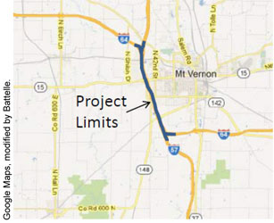
I-70/I-57 Interchange, Effingham, Illinois
The I-70/I-57 interchange is located in central Illinois. I-70 is a four-lane facility that serves as a major east-west freeway and freight corridor across the United States, and is also the major route between St. Louis and Indianapolis. I-57 is also a four-lane facility serving as a major route connecting Chicago with points south. For a section of approximately 6 miles, these routes are concurrent. IDOT determined that there was a need to reconstruct and improve the area where this section is located (Figure 1). The reconstruction project occurred between December 2010 and October 2012.

The 2010 annual average daily traffic (ADT) of these two routes where they are concurrent was approximately 45,000 vehicles per day, with 45 percent trucks (which could become as much as 90 percent trucks at night). Although a fairly high volume for a four-lane section, prior to construction, traffic generally operated uninterrupted at interstate speeds throughout the day and night. During reconstruction, however, capacity reductions created by the required reductions/elimination of shoulders, lane shifts, temporary lane closures, etc. were expected to generate periods of congested, stop-and-go traffic. This project was located on a rural interstate where drivers would not anticipate having to stop.
The I-57/I-64 Interchange, Mount Vernon, Illinois
Located approximately 70 miles south of Effingham, the I-57/I-64 interchange at Mount Vernon, Illinois, was another project location where IDOT officials elected to specify and implement work zone ITS technology to protect against rear-end crashes and provide drivers with delay information to help facilitate real-time diversion decisions. Like the I-70/I-57 project, this project was located in a rural area where drivers would not anticipate having to stop. Also similar to the I-70/I-57 interchange in Effingham, the I-57/I-64 interchange included a section where both routes ran concurrently on a four-lane cross-section. However, the length of the concurrent route was less, approximately 4 miles. Figure 2 illustrates the project location.
The 2011 ADT in this section was 39,610 vehicles per day with 33 percent trucks, which the interchange could typically accommodate. IDOT initiated a 2.5-year project to reconstruct and widen the interchange. The proposed improvement included construction of new continuously reinforced concrete pavement in both directions and a new third lane added in the median. The project was constructed in several stages between 2011 and 2013. During one stage, one lane northbound on I-57 and one lane westbound on I-64 were to be closed to eliminate the need to construct temporary pavement to accommodate the two normal lanes of traffic. The lane closures were expected to create congestion during certain days and times, which could lead to rear-end crashes that IDOT wanted to avoid. During other phases, reduced lane and shoulder widths, lane shifts, and other construction-related conditions were expected to reduce capacity and also increase the potential for occasional traffic queues to form.
Applicability of the Engineering Design Process to the Case Studies
Defining the Problem
|
Key Problems
|
The primary problem that concerned IDOT personnel in both project locations (I-70/I-57 and I-57/I-64) was the potential for rear-end crashes to occur due to occasional traffic queues caused by the project that would be unexpected by drivers on the rural interstate. Some severe traffic crashes attributable to work zone queues at past projects had raised the issue to one of the top safety concerns for the department. The project work conditions that were anticipated to potentially cause such queues differed slightly for each location, but in both cases the ability to predict when (or even how often) such queues would be created would be highly limited. In addition, the effects of any incidents that occurred within the project limits would be exaggerated due to the loss of available shoulders. Finally, although the safety concern about queues was the major problem, the resulting delays generated by such queues were also a concern to project staff.
For the I-70/I-57 project, the frequency of queue formation was not estimated beforehand, but was expected to be relatively low and unpredictable. For the I-57/I-64 project, IDOT performed an analysis using the Federal Highway Administration (FHWA) QuickZone traffic analysis tool2 to determine how far back the queues would typically develop if a lane were closed. Based on their estimate, they anticipated up to 3 or 4 miles of queue in the northbound I-57 direction. They based this on upstream ADT values that they factored out to hourly volumes.
Specifying Key Requirements of a Solution
|
Solution Requirements
|
For both projects, a primary requirement of a solution was the ability to detect and warn approaching traffic whenever traffic slowed and formed queues. A second requirement was that the solution be able to encourage travelers to use nearby alternative routes when queues and delays became significant. The determination of what constituted “significant” delay and congestion could be made later in the process.
Although not necessarily defined explicitly as a solution requirement by staff at either project, it was generally understood that the warnings needed to occur in near real time without requiring either IDOT or other personnel to take action to initiate the solution. In both projects, it would be difficult to justify constant staff time devoted to monitoring conditions and then initiating a response if and when queuing occurred at a work zone.
Specifically for the I-70/I-57 project, the work zone ITS requirements (termed the work zone transportation management system, or WZTMS by IDOT) were based on the following overall objectives:
- Reduce the frequency and severity of rear-end collisions in slowed or stopped traffic,
- Provide real-time delay information to travelers for major traffic movements within the project, and
- Direct traffic onto alternate route detours when necessary (i.e., for full interstate closures).
Early in the planning process for the I-57/I-64 project, a decision was made to employ a smart work zone traffic monitoring system. IDOT District staff worked with its central office staff, FHWA, and Illinois State Police (ISP) to incorporate a description and specifications for a smart traffic monitoring system” as a bid item in its contract bid documents.
Identifying and Evaluating Alternatives
Based on the need for automatic queue warning and delay information dissemination, staff at both projects decided early on that some type of work zone ITS would be deployed. There had been previous efforts by IDOT to warn drivers approaching a work zone with queues through the use of either enforcement personnel positioned upstream of the work, or through the use of IDOT staff with truck-mounted changeable message signs (CMS). The difficulty of predicting when queues would occur, having sufficient staff available to schedule during those times, and keeping the warning device (enforcement vehicle or the truck-mounted CMS) in the proper location relative to the end of the queue reduced the practicality of these approaches. IDOT staff were also concerned with the potential liability associated with sometimes, but not always, being able to have an enforcement vehicle or truck-mounted CMS present when queues were expected. To address these concerns, and to provide continuous and near real-time detection and warning, an automated system was needed.
For the I-57/I-64 project, IDOT had also considered an additional non-ITS solution knowing that capacity values dropped significantly in past work zones when 11 foot lanes were used, as vehicles would not drive next to large trucks in those conditions (trucks tended hug the lane line). In the past, they had provided a regular 12 foot lane and a narrower lane next to it, and attempted to get trucks to use the wider lane (i.e., TRUCKS USE LEFT LANE), but that technique did not work very well due to a lack of compliance and issues when approaching a left lane closure. Consequently, this non-ITS solution was not selected.
Selecting, Designing, and Procuring the Best Solution
Overview
Based on the decision to use work zone ITS to address its needs for queue detection and warning and encouraging diversion, IDOT incorporated a description and specifications for a “smart traffic monitoring system” as a bid item in its contract bid documents. Selection of the actual system was handled by the contractor, in consultation with IDOT staff. Design specifications included in the two project documents did vary quite substantially in terms of their length and specificity; yet both yielded systems that performed very similar functions following fairly similar logic.
Common items specified in both sets of system provisions included the following:
- Internet-based software to allow IDOT and contractor to monitor components of the system in real time,
- Capability to compute travel times and delays for each direction and update frequently,
- Automatic ability to determine messages to display to motorists based on a predetermined algorithm,
- Posting of predetermined messages on appropriate CMS,
- Ability to allow operators (including IDOT staff) to override the system to post messages as needed, and
- Capability to operate automatically on a continuous (24/7) basis.
However, the two projects differed in terms of the types of details included in specification of system components to be deployed.
The I-70/I-57 Solution
For the I-70/I-57 area, project staff developed a special provision document outlining the required number of devices and functions of the system. The document development process involved brainstorming discussions with various IDOT district and project staff and several manufacturers, and review of similar documents previously used by IDOT and others. In particular, traffic sensors capable of collecting data on both traffic volumes and speeds across multiple lanes of traffic were specified. The sensors were to be of a type not degraded by inclement weather conditions including precipitation, fog, darkness, dust, or road debris.
A WZTMS was part of a special provisions document describing an “automated, portable, real-time work zone system” to be deployed. Specific requirements of the system included:
- 25 CMS, capable of remote control via a central computer base station,
- 25 portable traffic sensors linked to the central base station,
- 20 remote video cameras linked to the central base station,
- 1 central base station with appropriate software and either wireless or dedicated phone line communications to link with the traffic management system components, and
- A password-protected project website (with color-coded map display) that project personnel could use to monitor conditions, check on operational status of the system components, etc.
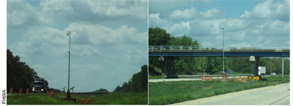
Additionally, portable solar-powered trailers were included in the system with radar and Wavetronics traffic sensors, and with video surveillance cameras (see Figure 4). Communications between devices was accomplished via cellular modems.
The I-57/I-64 Solution
IDOT District staff worked with its central office staff, FHWA, and Illinois State Police (ISP) to develop the description and specifications for its system to include in the contract bid documents. IDOT chose to pursue a turn-key type of system involving COTS technology rather than developing a system from scratch in-house. The system design requirements for key features and functionalities of the I-57/I-64 project were defined by IDOT through a special provision contract document for “an automated Smart Traffic Monitoring (STM) System.” The contractor was left to identify the vendor they wanted to use (with concurrence of IDOT staff). The contractors, in turn, conducted their own informal assessment of the systems available, and made a choice of system.
The system was to cover both I-64 and I-57 in advance of the project (no mention was made of the amount of roadway in advance that was to be covered). The contractor was to be responsible for furnishing, installing, maintaining, removing, and programming the various system components to make the overall system functional. It should be noted that the provision was much less specific than the system installed in Effingham.
The contract documents for the I-57/I-64 project did not include requirements for volume data or inclement weather condition performance, but specified that the traffic sensor devices to be used (termed “Smart Monitoring Devices” or SMDs) were to be crashworthy in accordance with National Cooperative Highway Research Program (NCHRP) Report 350 (13) or be protected by an NCHRP 350-compliant device if placed within the clear zone (30 feet from the edge of pavement). IDOT required the system to be capable of notifying drivers of stopped traffic conditions ahead (speeds less than 30 mph) and to be able to notify drivers of actual traffic backup delay times. The number of devices to be used was to be specified by the project engineer.
Some key components of the special provision for the I-57/I-64 project included:
- Lane Closures: The STM system was to be able to display dynamic messages from the system for lane closures at a single location.
- Schedule: The STM system was to be 100 percent operable seven days prior to the Contractor closing a lane of traffic. The system was then to remain in operation 24 hours a day and 7 days per week until project completion.
- Function: Components of the system were to include Smart Monitoring Devices (SMDs), CMS, and control software for the various communication functions that were required. The system was to collect real time vehicle data at various locations prior to and within the lane closures to alert drivers of delay times through the lane closure, of stopped traffic ahead, and of alternate route options. The control software was to take the real-time vehicle data and communicate appropriate messages on CMS. Messages were to be in real time and dynamic based on the data collected at the STM monitoring points. The system was also to be able to inform the District Office of traffic delays via the internet.
Deploying the Solution
The I-70/I-57 Solution
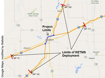
For the I-70/I-57 project, a system provided by Ver-Mac, Inc. was deployed over a total of 76 miles (beginning 10 to 12 miles upstream of the project in each direction; Figure 3). This provided sufficient advance notification of any queues, and gave timely information on adequate alternative routes so that motorists could access alternative routes if they chose to divert in response to the messages.
Overall, deployment and operation costs for this project totaled $1.545 million. The special provision called for the contractor/vendor to bid a per month unit price for the system to include all maintenance, operation, and relocation costs of the system. The cost consisted of the following:
- Initial mobilization and deployment of the WZTMS components, budgeted at $1.5 million, and
- Traffic management system operations and maintenance, budgeted at $1,800 per month over 25 months ($45,000 total).
IDOT always intended for the system to remain operational and be used during three other construction contracts that were scheduled to occur within the section over the next several years. The next contract that was let also included both of the above components, but bid at much different values:
- Initial mobilization of additional sensors, signs, cameras, budgeted at $78,750, and
- Traffic management system operations and maintenance, budgeted at $29,767 per month over 25 months ($744,188 total).
The contractor and vendor noted that this particular bid was fairly easy to estimate because IDOT specified exact equipment and the quantities to be procured. If bid requests are more open-ended in describing the desired operational condition, it can be challenging for vendors to compete on an even playing field, particularly if offering helpful additional technologies and innovation for a low-cost bid. At the same time, IDOT officials noted that it was difficult to know in advance how much equipment was needed (and where), and so they had to make some adjustments once the system was deployed (e.g., moving some equipment, obtaining additional devices where more were needed).
A detailed logic tree was developed to determine the two-phase messages to be displayed on the portable CMS (PCMS) based on traffic speeds measured and delays calculated, as shown in Table 1. For this deployment, the only communication of information with the motoring public was via the PCMS. The website developed for the project was for internal contractor/vendor/IDOT use only, and was not integrated into other traveler information sites operated by IDOT.
The entire system was tested for an initial two-week period. The traffic control supervisor (required elsewhere in the project specifications) was required to assist in the day-to-day operation of the system and serve as the on call contact for all notifications from the system. The vendor worked closely with the contractor and IDOT to ensure that the system met all desired specifications, and provided ongoing support to both in teaching them how to use the system and in making adjustments to the system as needed over the course of the project.
| Traffic Condition Logic | Phase I Message | Phase II Message | |
|---|---|---|---|
| No traffic congestion detected | NO DELAY TO <I-57 or I-70> | ROADWORK XX MILES AHEAD | |
| Speeds less than 40 mph detected | SLOW SPEEDS AHEAD | PREPARE TO STOP | |
| Significant delays detected (presented on PCMS farther upstream from the congestion) | XX MIN DELAY | NEXT XX MILES | |
| Even more significant delays detected | XX MIN DELAY | CONSIDER ALT ROUTE | |
| Delays exceeding a maximum threshold value detected (i.e., 20 minutes) | Certain signs | MAJOR DELAYS > 20 MIN | ALT ROUTE EXIT XX |
| Delays exceeding a maximum threshold value detected (i.e., 20 minutes) | Other signs | EXPECT MAJOR DELAYS | <Direction> BOUND <I-57 or I-70> |
The I-57/I-64 Solution
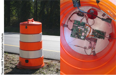
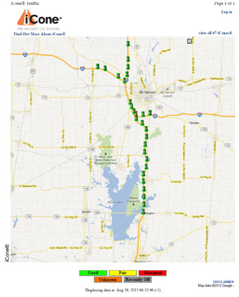
For the I-57/I-64 project, a system using iCone® portable traffic monitoring devices was implemented. The iCone® is a self-contained, battery-powered unit that consists of a radar detector, GPS antenna, cellular and backup satellite communication capabilities, and processor. Figure 5 illustrates the device. Figure 6 illustrates the layout of the iCone devices approaching and through the project.
No quantities were specified in the contract documents. However, the deployed system, as proposed in the winning bid by the contractor, ultimately consisted of the following:
- 32 iCone® devices (with their sensors) placed on all four approaches to the interchange,
- 15 CMS on those approaches, and
- Website portal to monitor the devices, traffic conditions, and messages displayed.
The sensors were spaced approximately 1 mile apart, beginning 3 to 14 miles upstream of the interchange, depending on the direction of travel. As congestion developed upstream from the interchange (most commonly in the northbound direction), messages on that approach communicated that traffic was slow or stopped ahead A distance to the queue and congestion was estimated based on the distance from each PCMS to the last downstream sensor that was reporting travel speeds in excess of 55 mph. It could then be assumed that the upstream end of the queue was someplace between that sensor and the next downstream sensor that was reporting slow travel speeds. To be conservative, the distance to that first downstream sensor would be what was disseminated as the distance to congestion.
If the queue extended beyond 2 miles, the messages changed to encourage drivers to divert to alternate routes. State Route 37 was a convenient alternative around the project, easily accessible at Exit 77. Because the alternate route for the I-57/I-64 project went through the city of Mt. Vernon, city officials were notified about the project and informed about using the route for diversion. Some efforts were also made to notify major shippers in the area. Specific outreach to the motoring public about the system was not performed. IDOT and the contractor/subcontractors were notified of the queue conditions via text messages and email notifications.
Multi-tiered message logic was developed for the PCMS, depending on their location. Some of the upstream signs were programmed based on the magnitude of delays computed by the system. Delay computations were based on queue lengths detected, which in turn had been calibrated over time by IDOT staff and by contractors who had driven through the project during congested conditions. Other signs closer to the project disseminated slow or stopped traffic messages to help prevent rear-end crashes at the upstream end of the queue. Table 2 illustrates the messages presented based on the current traffic status measured by the system.
The system was procured by the subcontractor, who owns the system, as an initial deployment as part of the construction project. A subsequent force account change order was used to expand the system to add more sensors and PCMS after queues occurred that were longer than originally expected:
- Initial system, budgeted at $1 million, and
- Subsequent force account to expand the system, budgeted at $172,200.
| PCMS closest to the project | Criteria to Display Message | Lowest speed downstream > 45 mph | Lowest speed downstream 30 to 45 mph | Lowest speed downstream < 30 mph | |
| PCMS closest to the project | Phase 1 Message | ROADWORK NEXT XX MILES | CAUTION SLOWING TRAFFIC | CAUTION STOPPED TRAFFIC | |
| PCMS closest to the project | Phase 2 Message | XX MIN THRU ROADWORK | SLOWING XX MILES AHEAD | STOPPED XX MILES AHEAD | |
| PCMS farther upstream from the project | Criteria to Display Message | Delay < 5 minutes | Delay 5 to 25 minutes | Delay 26 to 45 minutes | Delays > 45 minutes |
| PCMS farther upstream from the project | Phase 1 Message | ROADWORK NEXT XX MILES | XX MIN DELAY AHEAD | XX MIN DELAY AHEAD | XX MIN DELAY AHEAD |
| PCMS farther upstream from the project | Phase 2 Message | XX MIN THRU ROADWORK | N/A* | CONSIDER ALT RTE EXIT XX | FOLLOW ALT RTE EXIT 77 |
Evaluation and Lessons Learned
Usage Statistics and Performance Evaluations
Statistics collected from both projects indicate that work zone ITS to warn traffic about queues and delays was an appropriate tool to deploy. As illustrated in Table 3, the relative frequency of activation of the PCMS was less on the I-70/I-57 project than on the I-57/I-64 project. This would be expected, as the latter imposed a long-term lane closure northbound that reduced capacity continuously and led to regular oversaturated (queued) conditions.
| Performance Metric | I-70/I-57 Interchange | I-57/I-64 Interchange |
|---|---|---|
| Warning Message Activation Frequency: |
|
|
| Message Activation Duration: |
|
|
IDOT and contractor personnel at both projects checked the travel times being displayed on the PCMS by conducting drive through runs, and monitored equipment status and displays to ensure that the system functioned as intended. Both project staffs had positive experiences with the systems, and believed the systems were helpful in reducing queues and managing traffic (e.g., encouraging some traffic to divert to alternate routes). System performance was monitored regularly through the internal website for the system, and any failures in devices were investigated and remedied.
A preliminary analysis of the I-70/I-57 project crash statistics from 2010 (prior to system implementation) and 2011 (after system implementation) saw nearly a 14 percent decrease in queuing crashes, and an 11 percent reduction in injury crashes, despite a 52 percent increase in the number of days when temporary lane closures were implemented in the project. Although it is not certain whether the queuing frequencies and conditions between the two years were similar, the trends were very encouraging.
Lessons Learned
A number of lessons were learned by personnel associated with both projects. These are summarized below.
Teamwork is important – Success of these systems required a team perspective, including IDOT personnel, the contractor, and the vendor, as well as close coordination and cooperation throughout the duration of the project to maximize the effectiveness of the system.
Camera coverage is useful, but not necessarily essential, for a successful system – At the I-70/I-57 project, traffic cameras were not specified by IDOT but were included in the final system deployed. Both IDOT and the contractor subsequently commented that the cameras were valuable for identifying and verifying when and where traffic issues arose and quickly determining how to best respond to mitigate the issues. However, the lack of cameras on the I-57/I-64 project was never mentioned as a problem by project staff. This could be due in part to the different project lengths involved. The I-70/I-57 work zone ITS covered significantly more interstate mileage than did the I-57/I-64 project. In addition, the loss of shoulders, reduced lane widths, etc. throughout the I-70/I-57 project meant that a stall or crash anywhere within the system coverage limits was fairly likely to cause a traffic queue. Conversely, the bottleneck location at the I-57/I-64 project was constrained to right at the interchange itself, a much more concentrated location that could be reasonably inspected other ways. Consequently, camera coverage to view reasons for traffic queues that developed was considered important at the one project, but less so at the other.
Calibrate to slightly overestimate delays – Project personnel at the I-57/I-64 project noted that they found (primarily through anecdotal conversations with friends and neighbors) that it was more acceptable to the public to slightly overestimate delays when disseminating this information, but not acceptable to underestimate delays. Consequently, calibration of the systems relative to the delays calculated and presented on the signs should ensure that the delays being presented, if in error slightly, err towards the side of overestimation.
A good system specification requires balance – Experiences from the two system deployments indicated a need to provide enough detail in the specifications to allow vendors to bid competitively, but not so much that it excludes many of the vendors from participating. The key is in understanding what features, data, functions, etc. are essential to meeting the system objectives. The area in which the two projects differed significantly was in the types of traffic sensor device capabilities specified, as well as the number of devices required. The I-70/I-57 project outlined the type and number of traffic sensors required in high detail, whereas the I-57/I-64 project specification regarding traffic sensors was more general.
The I-70/I-57 project specified the use of traffic sensors that could provide detailed volume, speed, and lane occupancy data, whereas no such constraint was added to the specification for the I-57/I-64 project. Ultimately, both types of systems appeared to work well for detecting and warning about queued traffic conditions. Since it was possible to quickly calibrate the length of queues detected at the I-57/I-64 project to delays experienced by motorists (because the location and capacity of the bottleneck remained fairly constant over the course of the project), this could be done with speed sensors, feeding an algorithm to convert queue length to estimated delay. At the I-70/I-57 project, the capacity reductions that caused queues varied, as did the location of the queue itself, so the algorithm to estimate delays required more detailed volume and occupancy data. Similarly, differences existed between the two projects in terms of the crashworthiness requirements of the traffic sensor devices. At the I-57/I-64 project, crashworthiness of the traffic sensors was deemed important in light of their location adjacent to moving traffic. Conversely, most of the traffic sensors used at the I-70/I-57 project could be located behind temporary barriers or other protective devices and so this feature was not considered to be as critical at the I-70/I-57 site.
Achieving the proper level of system specificity in contracts is likely to continue to be a challenge for agencies going forward, as arguments can be made supporting both approaches. A more prescriptive specification, defining equipment capabilities very precisely as well as the number of such devices, typically yields vendor bids that are truly an “apples-to-apples” comparison and thus allow for a true low-bid selection to occur. The main caveat to this is that the specificity of the devices should be only what is necessary to achieve the overall results of the system, rather than being a way (whether real or perceived) to exclude other vendors whose technology does not meet the specification. It is fairly easy to include specifications that seem innocuous, but that have the effect of eliminating bidders.
Conversely, a less prescriptive specification generally allows for more innovation by the vendor to deliver a system that meets the desired functions and level of performance that is desired, but is more difficult to assess across multiple bidders. The lack of screening and pre-implementation testing to verify system compliance of desired functions and performance standards can further hamper efforts to compare systems to a less prescriptive specification.
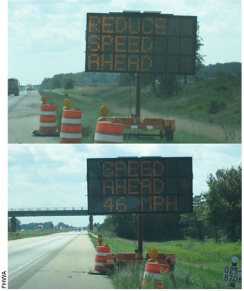
System adjustments are likely to be required after initial deployment – Work zone ITS, even COTS systems, need to have capabilities incorporated into the specifications to allow for adjustments to be made in the field once the technology has been installed and calibrated. IDOT and contractor personnel from both projects indicated the need to “tweak” things early on in deployment as information about actual traffic conditions, construction-related geometric constraints, and other site-specific details were determined. For example, messages posted on the PCMS at the I-70/I-57 project were adjusted slightly from the logic specified in Table 1 once installed as a way to improve overall system operations. As Figure 7 shows, the original generic “REDUCE SPEED AHEAD” message called for in the specification was altered to display actual average speeds to be encountered downstream, as it was determined that the posting of a specific speed appeared to be interpreted as a more accurate message and prompted greater driver reaction to the message. Such changes were made as both IDOT and the contractor gained experience with the system and with how motorists responded to the various messages presented.
At the I-57/I-64 project, initial estimates of queuing expected in the northbound direction once the interstate was reduced to one lane proved to be very inaccurate. IDOT officials indicated that they used ADT values from an upstream sensor, and factored them down to typical hourly volumes to evaluate using QuickZone. Almost immediately after deploying the system and closing the lane, a traffic queue developed that extended upstream nearly 11 miles, far beyond the system coverage that had been initially bid based on IDOT’s original expected queue lengths. A force account was subsequently used to add more devices to the system to protect against queues growing beyond the limits of the system. In addition, a logical detour route (state route 37) northbound around the project involved a trip that was 26 minutes longer than via I-57. After the system was deployed, project personnel determined that once a queue reached 2 miles, delays were approximately 20 to 25 minutes. Thus, the system logic was changed to encourage diversion via delay messages once queues reached 2 miles, instead of the 3 to 4 mile queue threshold that was initially planned for triggering delay messages to be disseminated. Finally, a related field modification was also required early on to close an entrance ramp from Hwy 37 onto I-64 westbound to prevent those diverting from trying to rejoin I-57 at the interchange rather than traversing the entire diversion route.
than what was Required in the Initial Special Provision (Top).
2For more information, see: https://ops.fhwa.dot.gov/wz/traffic_analysis/quickzone/
< Previous | Next >