Travel Time on Arterials and Rural Highways: State-of-the-Practice Synthesis on Arterial Data Collection Technology
1. Introduction
1.1 Background and Objectives
Travel time to a destination is a key piece
of information that motorists want and need.
It is vital in travelers making good decisions
about which route to take and whether to divert
from their planned path. If motorists were
to be provided travel time information on
arterial highways, they may plan their trips
accordingly with this new information, decreasing
delays and the potential for congestion downstream.
They may also be warned in advance of an incident,
allowing sufficient time to choose an alternate
route around congestion and delays.
Technology now makes it feasible to provide
drivers with real time information about how
long it will take to reach a given destination.
Many jurisdictions within the United States
collect information on freeways and that information
is generally provided to travelers via DMS
along freeways. In contrast, cases where the
information is collected and displayed on
non-freeway roads such as arterials are relatively
rare. Figure 1 shows examples of typical arterial
practice.
Figure 1. ATT Signs in Chandler,
Arizona
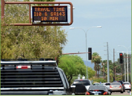
Source: City of Chandler & Oz
Engineering, 2011 |
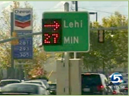
Source: Video capture from Wimmer,
2010 on ksl.com |
Travel time is also a key piece of information
for transportation agencies. Real-time travel
time information can allow agencies to monitor
roadway performance, identify problems, develop
forecasts, plan future projects, and evaluate
the effects of new projects. Travel time data
can also help to meet goals for integrated
corridor management or meet Federal information
provision mandates such as the Real-Time System
Management Information Program, which was
included in Section 1201 of the Safe,
Accountable, Flexible, Efficient Transportation
Equity Act: A Legacy for Users (SAFETEA-LU).
Current use of travel times for arterials
is still limited. However, interest is high
and examples of successful implementations
are becoming increasingly common. Researchers
are investigating a variety of data collection
methods that can be applied to arterial settings,
such as the use of Bluetooth detection technology
(e.g., Hardigree, 2011; Puckett & Vickich,
2010), toll tag readers (e.g., Wright and
Dahlgren, 2001), automatic license plate readers
(e.g., Eberline, 2008), in-pavement magnetic
detection (e.g., Klein, Mills, & Gibson,
2006), machine vision, radar/microwave/LIDAR
(e.g., Jeng, 2010), crowdsourcing (e.g., INRIX,
2012), CV, cell phone signal monitoring (e.g.,
Avni, 2007), and inductive loop detectors
(e.g., Blokpoel, 2009). As this list demonstrates,
there is a litany of data collection technologies
which have been used for ATT, but each has
its own advantages and disadvantages. At this
point there is no comprehensive guidance on
data collection technologies and procedures.
There are numerous reviews and syntheses
of travel time data collection in general.
But, travel time data collection and dissemination
for arterial highways has unique challenges
for the practitioner.
For example:
- Travel times are not collected in isolation,
and often the uses are determined by the
goals and communication needs at a location—and
these can be quite different for and between
arterials.
- Arterial roadways can vary greatly in
their location and use: urban arterials
often parallel major freeways in more densely
populated areas while rural arterials often
act as major alternates through less densely
populated areas.
- Although the access to technologies may
be similar to freeways, arterials present
unique issues such as signal timing disruptions,
dropping out of the route at various points
such as parking lots, side streets, etc.
The TMC Pooled Fund Study has recognized
the need to determine if technologies are
being developed to obtain data necessary for
calculating travel times that address specific
challenges. State and local agencies face
the challenge of providing real-time travel
time to motorists—which entails obtaining
information on arterials—in a manner
that allows drivers to take full advantage
of it.
To further hone the opportunity of providing
useful and accurate travel time information
in arterial locations, it is important to
ask the following questions:
- What insights and experiences have agencies
developed with these technologies, and what
are the best uses of these technologies?
- Given challenges faced in calculating
and providing travel time information on
arterial highways, how feasible is deploying
such technology?
The purpose of this project
and the resulting report was to identify,
review, and synthesize information on current
and potential future efforts in real-time
travel time on arterials. There were four
main objectives: a) identifying, reviewing,
and synthesizing available and emerging technology
(both nationally and internationally) for
obtaining data necessary for calculating travel
times on arterials; b) collecting and summarizing
agencies' experiences with using such technology;
c) providing guidance to agencies for making
the best use of available and emerging technologies
to meet future needs; and d) determining the
feasibility of deploying such technologies.
The first objective (reviewing)
is dealt with while being mindful of the ever-changing
nature of recent technological advances. Unlike
synthesis reports in non-technological domains
that focus on research publications, many
of the sources for this report were from vendors,
State agencies, and practitioners who are
the most up-to-date on the rapidly changing
technological developments and implementation
approaches.
The second objective (experiences)
is addressed by incorporating lessons learned
and advice (including from unsuccessful projects)
from agencies' experiences using a given technological
approach. These lessons give extremely helpful
insights that can be provided to the practitioner
and allow the current synthesis to go beyond
a simple summary of documents.
The third objective (guidance)
is based on a synthesis of the first two,
taking information gained from reviewing technologies
and merging it with real-world experiences
of practitioners. This led to the development
of lists of considerations in the form of
questions (and high level guidance in response)
that a practitioner should use when going
through the phases of assessing, planning,
selecting, acquiring, implementing, managing,
and evaluating an ATT system.
The final objective (feasibility
assessment) was not a formal financial
feasibility analysis. Instead, feasibility
is taken in a broader context and refers to
environmental constraints that a practitioner
should take into consideration when weighing
what type of system to implement. Financial
information is given where available, but
only in the context of background information
to use when evaluating the entire practicality
of an implementation approach.
The primary audience for
this report is transportation agencies who
are either interested in implementing an ATT
data collection system, or considering making
changes to an existing system. It is important
to obtain, synthesize, and distribute information
now so that objectively based recommendations
can be provided to practitioners as they design
and implement such systems.
It should be noted that the current report
focuses on ATT data technology considerations
and is not a primer for general travel time
best practices. A good source of general travel
time guidelines can be found in Turner, Eisele,
Benz, & Douglas (1998). This report also
focuses on travel time data collection methods
that use vehicle speeds or link travel times
as data sources. Efforts to estimate travel
times using other data sources (e.g., traffic
volumes) such as the Minnesota Arterial Travel
Time Project (Athey Creek Consultants, 2009)
are not addressed. In addition, there is a
separate report from this project that focuses
on travel time data collection technology
used for rural highways.
1.2 Methodology
The information search for this project involved
two main components: the review of data collection
technology and the review of practice. The
search effort began with an organized set
of keyword searches. Five search categories
were created to encompass the key project
dimensions. Using these categories, a list
of search terms was compiled within each category
(see Table 2).
Table 2. Table of Search Terms and
Categories
| Travel time |
Data/data collection |
Arterial |
RFID |
Network |
|
Travel time
Journey time
Traveler information
|
Monitor*
Real-time
Calculat*
Estimat*
Technology
Infrastructure
Communicat*
Instrument(ation)
Hardware
Intelligent Transportation System (ITS)
Software
Install
Collect
Wireless
|
Off-freeway
En-route
Freeway approach
On-ramp
Surface street
Remote
Stand-alone
|
Connected vehicle
Video/camera
Satellite
License plate reader
Bluetooth
GPS
Cellular/cell phone
In-pavement/loop detect*
Radar
LIDAR
Anonymous Wireless Address Matching/AWAM
|
Guidelines
Best practices
Operations
Implement(ation)
Traffic
Accuracy
Cost
|
| * Indicates wildcard character |
As an example, the search terms "Bluetooth" and
"GPS" were both placed in the Specific Technologies
category. The table below shows the initial set of search
terms used within each category. Additional search
terms were added for follow-up searches. Note that an
asterisk represents a "wildcard" character.
The keyword search effort revealed a substantial
body of literature on data collection technologies and
numerous evaluations of ATT systems, often comparing
novel ATT data collection approaches against other
data collection approaches or ground truth data.
The search effort then expanded to include targeted
searches to explore the state of the art technologies
and practices used for ATT. This search revealed
a rapidly expanding world of data collection
technologies and practices.
Finally, contacts with experts and implementers
were made to gain a clearer understanding
of current and emerging practice and to acquire
additional details and direct experience reports.
Two general approaches were used: 1) contacts
with heads of committees and professional
organizations, and 2) contacts made directly
with travel time system implementers to learn
about relevant implementation details. Individuals
and organizations were selected for contact
based on knowledge gaps that they were expected
to be able to fill and their involvement in
travel time programs of interest. Contacts
with implementers provided a basis for implementation
summaries and case studies with emphasis on
explaining project logistics, decision making
processes, and lessons learned. Organizational
contacts provided little new information about
current practice; many implementations of
ATT have not been widely publicized and do
not appear to be widely known among transportation
engineers.
1.3 Organization of Synthesis Report
The following chapters of this report are
organized around three main topics of interest
to practitioners:
Chapter 2 discusses available
and emerging RTT data sources as well as
implementation considerations, advantages,
and limitations of each.
Chapter 3 provides two
detailed case studies and additional brief
summaries of select practices in RTT data
collection. These summaries reflect a broad
range of implementation objectives, strategies,
technologies, and constraints.
Chapter 4 brings together
what we know about data sources, technologies,
and current implementations to develop a
set of best practices that are based on
systematic evaluation, where possible, and
real-world experiences. Rather than prescriptive
guidance, this chapter emphasizes identifying
options and practices that can be adapted
to the needs of a particular situation.
It is framed around questions that a practitioner
can ask as he or she goes through the stages
of developing and implementing an RTT data
collection system.