Best Practices for Road Weather Management
South Carolina DOT Hurricane Traffic Evacuation Operations
South Carolina has an extensive network of designated evacuation routes for motorists to use should there be a need to vacate coastal areas for a hurricane. There are twelve major evacuation routes, each approximately 100 miles long. From these twelve, one interstate and three primary routes can be reversed for higher evacuation traffic capacity leading away from the coast. All evacuation routes are “loaded’ with vehicles from a designated area of the coast. Traffic is directed by signs and law enforcement to ensure maximum utilization of each route and to avoid over capacity of others. High coastal population numbers will present a capacity challenge to most routes used for evacuation. By aggressively managing traffic flow during evacuation, a higher probability of minimal drive times and reduced frustration for motorists will be realized.
System Components: Intelligent Transportation System (ITS) elements play an integral role in the evacuation operations. All ITS infrastructure including Incident Responders, permanent and portable changeable message signs, traffic cameras, highway advisory radios, congestion sensing devices, and 511 Travel Info have been developed since Hurricane Floyd in 1999. The South Carolina Department of Transportation’s (SCDOT) traffic counters were in place prior to Hurricane Floyd and remain a valuable part of evacuation traffic evaluation today. Traffic camera video, congestion monitoring abilities, and traffic count data are used by the State Emergency Operations Center (SEOC) Emergency Traffic Management Unit to monitor and alter operations on evacuation routes as needed by the South Carolina Highway Patrol (SCHP) and SCDOT. The video viewed at the SEOC is fed through dedicated fiber optic cable from the State Traffic Management Center (STMC). This offers an extra measure of reliability and allows camera control of all SCDOT’s 302 video cameras statewide. A large number of these cameras are on coastal evacuation routes and are used daily to manage high traffic volumes in these areas.
SCDOT’s Incident Responders, known as the State Highway Emergency Program (SHEP), are the other critical element of evacuation operations. During hurricane evacuation operations, they assist in keeping key evacuation routes in Myrtle Beach, Charleston, and Columbia free of incidents that lead to traffic congestion. SHEP units from northern areas of the state assist in covering the entire length of reversed Interstate 26 (I-26) from Charleston to Columbia (100 miles) assisting to clear incidents that may impede traffic flow. Figure SC-1 is an aerial view of the termination of the evacuation reversal of I-26 near Columbia.
System Operations: SCDOT and SCHP have adopted the Incident Command System (ICS) as the operational framework used for coastal evacuation. ICS will be used in all situations where Emergency Traffic Management is necessary throughout the state for adverse weather, man-made disasters, and so forth. ICS organization and concepts have been used successfully by fire services for decades and have proven themselves to be the best framework for all emergency services and disaster relief.
SCDOT and SCHP have jointly developed ICS Incident Action Plans (IAP) to address actions associated with each hurricane reversal route. IAPs have been developed for all evacuation activities along all coastal exit routes. Public response partners such as local law enforcement, fire services, emergency medical services, the law enforcement branch of the State Natural Resources Division, the State Law Enforcement Division (SLED), civil air patrol, National Guard, and county emergency management entities are incorporated in each IAP. This development effort has taken a substantial amount of detailed work by the parties involved.
The IAP concept has been tested through many Table Top Exercises (TTX) conducted with state and local partners and through a full-scale exercise last year for the simulated reversal of I-26 from Charleston to Columbia. The full-scale exercise entails bringing all assets, those of law enforcement and SCDOT traffic control devices, to each interchange on I-26 from Charleston to Columbia. The Interstate is not actually reversed but everything necessary to do so is at the roadside. The IAP concept is continuously exercised with the state’s annual full-scale simulation of the evacuation operation and the manning of evacuation traffic control points. During the exercise, simulated traffic problems will be presented to field personnel for mitigation by using IAP procedures identified through yearlong training.
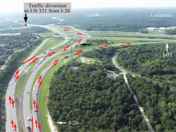
Figure SC-1. Aerial view of I-26 near Columbia, SC where 100-mile evacuation reversal is terminated.
All evacuation routes are planned to provide lane continuity. For example, at major intersections or other transition points, two lanes will transition to two lanes and not be reduced to one. However, there are some exceptions as some roads are not wide enough to accommodate such continuity. There is extensive use of static traffic control devices (cones, barricades, etc.) and law enforcement personnel when a lane reversal is employed.
To aid in the goal of lane continuity, SCDOT has employed ITS technology to its maximum advantage along evacuation routes. Further SCDOT has instigated the use of ICS/IAP procedures to maximize operational efficiency and has assured sound, logical communications protocol during hurricane events.
Transportation Outcome(s): The growing number of permanent residents within fifty miles of the coast and the high number of tourists that visit the coast each year during hurricane season motivate SCDOT to provide safe, effective evacuation operations. The coastal access road system has not kept pace with the population growth—only minor traffic capacity improvements have been made in the last forty-five years. This combination of constrained road system and high population makes it imperative that the maximum traffic capacity is achieved during evacuation events.
The new ICS is paying many dividends in its simplicity, concise instruction and adaptive flexibility. Stakeholders and the public have realized the benefits accruing to them through this cooperative framework and periodic review process. The current initiative represents the state’s best efforts to protect the public when a hurricane threatens the coast. SCDOT is prepared for evacuations but will continue to evaluate yearly and improve as resources permit.
Implementation Issues: Two implementation issues of the state’s evacuation plans are availability of evacuation routes and appropriate signage along those routes. The SCDOT and SCHP assess all routes in the field yearly to ensure evacuation signage is in place. Also, evacuation routes are altered if needed during the yearly assessment.
Prior to hurricane season, meetings are held to reexamine emergency traffic flow procedures, confirm or alter staffing at traffic control points along the routes, and verify the ITS components used for hurricane evacuation traffic. These meetings occur in each of the state’s three major coastal evacuation areas with county emergency management officials, local law enforcement, SCDOT, SCHP Troopers, fire services, Emergency Management Services, and the National Guard in attendance.
In 2012 the ICS/IAP concept for evacuation management was presented in the regional meetings with all partners. Additional meetings were held by SCDOT and SCHP to assure a familiarity amongst stakeholders during transition to the ISC approach. It is very important that all involved embrace ISC and understand their role in the IAP.
Contact(s):
- Richard F. Jenkins, P.E., State Traffic Management, South Carolina Department of Transportation (SCDOT), 803-737-1454
- Captain Robert G. Woods, IV, MA, CPM, Emergency Traffic Management Unit, South Carolina Highway Patrol (SCDPS), 803-896-8722.
Reference(s):
Keywords: Hurricane, emergency traffic management, Incident Command System (ICS), Incident Action Plan (IAP), Intelligent Transportation System (ITS), traveler information, 511, Incident Responders, emergency management, table top exercise, hurricane evacuation signing, highway capacity, hurricane evacuation studies, ingenuity.
previous | next