| Skip
to content |
|
Improving Traffic Signal Management and Operations: A Basic Service ModelAppendix 1. Signal Timing Versatility ConceptsVersatility is one of the more critical points in objectives for signal timing programs, but it receives little attention or consideration by many practitioners. The typical current approach to performing signal timing is as follows:
Several of these steps are quite expensive, particularly including the collection of 15-minute turning-movement counts at all intersections. This data-driven process implies that traffic volumes are more important than traffic performance, given the resources required to collect them. A key weakness of this approach is that volume data is of limited value to the practitioner, and often too expensive to collect routinely. Practitioners use volumes primarily because optimization software requires it. And the software requires it because we have no easy means of directly measuring what is really important, and that is whether the timings are serving the representative desires of the users of the network. These desires represent aspects of the overall motorist objective for smooth, predictable flow, and we characterize them generally based on some combination of the following objective functions:
Modeling these objectives, especially considering that all the objectives are important at some level in all situations, is difficult even for microscopic simulation software. Most signal optimization software chooses some simple combination of a few of these objectives, and even these are quantified by simplistic models. The models themselves have been designed to use the only traffic data that is readily available, and that is traffic volume. The traditional approach therefore starts with an expensive data collection process, which is required by a simplistic model that considers too few objectives, to produce signal timings optimized for a single 15-minute period which may or may not be usefully representative of other periods, especially over the coming months and years. Skilled practitioners usually then are compelled to spend considerable time making field adjustments of the resulting timings, based on their experience-driven and implicit understanding of meeting the needs and expectations of as many of their users as possible. This process is also resource-intensive, and not all agencies have access to such skills. Finally, the data on which the system is designed changes constantly. Timings narrowly optimized for several 15-minute periods may not provide the versatility needed to remain reasonably close to an optimum throughout any given day, or over time as daily, weekly, seasonal, and long-term trends affect demand. This leads to the usual recommendation to perform the above process again in an arbitrarily short time, such as every two years. Tools are not available to evaluate signal operation on the basis of better-defined objectives and optimization processes that use measured performance rather than modeled performance. Rather than the typical steps listed above, a better approach that is more sensitive to available resources and more versatile, might be the following:
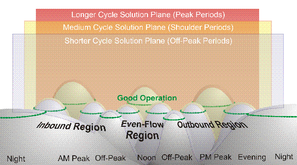
Because the cycle length, offset, phase sequence, and main-street green time are largely determined by the geometry of the network, using volume-based optimization tools often has little additional to offer. Finding an appropriate progression solution may be difficult in more complicated networks, but even "guess" volumes can often find those solutions as accurately as measured volumes, especially considering the potential inaccuracy of those measurements. Often, optimization processes work to levels of precision far in excess of needed or supported accuracy, which is an error most engineers are trained to avoid. The figure below represents the concept of versatility.
Graphic showing a solution surface, where the surface represents signal timing effectiveness. Hills represent signal timings for specific peak periods, with the hills rising above an altitude of acceptability that cuts across all hills. The tops of the hills above this altitude represent good operation. The hills progress from left to right, representing night conditions, morning, off-peak, noon, off-peak, afternoon, evening, and night periods of a typical day. Light traffic conditions are in the foreground, and heavy conoditions are in the background, with moderate conditions in the middle. Foreground hills represent off-peak solutions, middle hills represent shoulder-period solutions, and distant hills represent peak solutions. The diagram shows that each solution is only full optimum for a brief period within the period for which it was designed, but remains acceptable until conditions move to the next hill.
Good operation is represented by the peaks in the solution terrain, and good operation can be maintained by jumping from peak to peak. The current methods used by many agencies attempts to identify a few peaks to broadly represent the terrain, rather than to start with the whole solution terrain and represent it with versatile timing patterns. Using this approach, the most complicated arterial street may be timed with a dozen plans, none of which requires data at most intersections and only a few of which require significant data or design resources. Most typical arterials would need less than half that many plans, especially if the signal timings are designed for versatility. Such an approach would provide good basic operation, saving expert resources for those conditions and geometries that demand more effort, such as congested conditions. It should be pointed out that a versatile set of signal timing plans designed to broadly accommodate the solution terrain can support the implementation of traffic-responsive operation far more easily, and are also much more resistant to degradation over time. previous | Table of Contents |
|
United States Department of Transportation - Federal Highway Administration |
||