5.0 What Does an Objectives-Driven CMP Look Like?
5.1 CHARACTERISTICS OF THE CMP
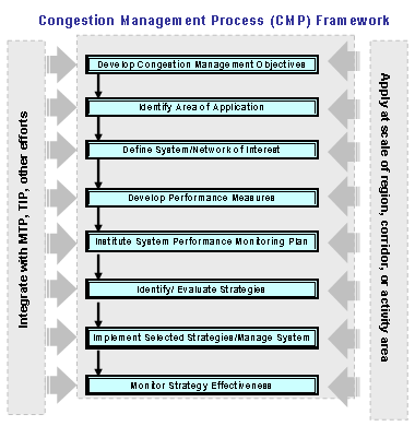
The Congestion Management Process should be viewed, not as something separate from or outside of, the planning process, but as an integral part of the planning activity. Just as travel demand forecasting and modeling enable planners to estimate future needs and analyze the impact of alternative capital investments, the CMP assists in identifying system deficiencies, and in analyzing and selecting alternative strategies to address congestion for inclusion in the MTP. Figure 5 (below) details the framework for stepping through the CMP starting with the application of the goals and objectives from the MTP.
5.2 DOCUMENTING THE CMP
Several different approaches are available for documenting the CMP process and its outputs. The MPO could develop a communications plan to inform and educate stakeholders on the purpose and content of the CMP. It is important to educate the stakeholders on the purpose for developing the CMP and the kinds of impacts the MPO is anticipating from implementation of the strategies. The communications should be in plain language. Simply informing stakeholders about the process is important, but not sufficient; ideally, the CMP should be incorporated into the region’s plans for public participation and involvement in the transportation planning process.
The CMP, as part of the metropolitan planning process, should be incorporated in the final Metropolitan Transportation Plan, either through a discussion of the congestion management process and its elements or by reference. If the CMP is incorporated by reference, it is important that the CMP documentation be readily accessible to the community that the process itself is open to participation and review through the MPO’s public participation plan. Strong linkages to the MTP, and opportunities for public participation in the process, are particularly important if CMP outputs are to be used during subsequent project development stages and documentation under NEPA.
Some MPOs will choose to issue a separate report or series of reports on the CMP. While the production of a “stand-alone” report can provide a means to focus on congestion challenges and proposed solutions, the document should be prepared in such a way that the CMP can be clearly understood to be an integral part of the planning process. The performance measures developed earlier in the congestion management process should be used to report on the success of implementing the CMP strategies.
5.2.1 STAND-ALONE CMP REPORT
To ensure that the CMP is accessible and well understood by stakeholders, the MPO might consider special reports or brochures advertising the process, including performance measures, strategies, and linkages to other aspects of the planning program. It is particularly important that decision-makers are aware of the CMP strategies and their potential benefits. Each of the governmental units, at the executive level and the business level, need to understand the importance of implementing CMP strategies.
If a stand alone CMP is done then the MPO should consider how to connect it to the MTP and TIP. Mention a number of MPOs have prioritization process to add projects that reward strategies that have been identified as congestion helpful.
5.2.2 CMP AS PART OF THE METROPOLITAN TRANSPORTATION PLAN
The CMP can be documented in the Metropolitan Transportation Plan through a discussion of the process and identification of strategies, projects, or programs that were generated through the congestion management process. The “8 Steps” of developing the CMP (described in section 3.3 above) should be documented as part of the MTP, or incorporated by reference. Discussion of the CMP and its outputs can provide a bridge in the MTP between transportation challenges currently facing residents of the metropolitan area, and the proposals for projects that will be accomplished in the out years of the plan.
5.2.3 CMP AND NEPA DOCUMENTS
The Final Rule on Statewide and Metropolitan Planning issued in February, 2007 (23 CFR 450.212, 450.318, and Appendix A to Part 450) provides specific reference to the use of the CMP. The Rule notes that.”.. the results of analyses from management systems (e.g., congestion, pavement, bridge, and/or safety) may shape the purpose and need statement.” (Appendix A, Part II Substantive Issues; Purpose and Need, 8.d)
The Rule also notes that “MPO(s), state(s), or public transportation operator(s) may undertake a multimodal, systems-level corridor or subarea planning study as part of the metropolitan transportation planning process.... The results or decisions of these transportation planning studies may be used as part of the overall project development process consistent with NEPA (42 U.S.C. 4321 et seq.) and associated implementing regulations (23 CFR part 771 and 40 CFR parts 1500–1508). Specifically, these corridor or subarea studies may result in producing any of the following for a proposed transportation project:
- Purpose and need or goals and objective statement(s);
- General travel corridor and/or general mode(s) definition (e.g., highway, transit, or a highway/transit combination);
- Preliminary screening of alternatives and elimination of unreasonable alternatives;
- Basic description of the environmental setting; and/or
- Preliminary identification of environmental impacts and environmental mitigation.”
These planning studies may be produced as part of the CMP and incorporated into the MTP. Both the findings and the supporting documentation can feed directly into the NEPA process.
To fully utilize the authority to link the transportation planning process with the NEPA process under 23 CFR 450, the planning studies and work (such as the CMP) must meet certain consultation, public involvement, and documentation requirements. See 23 CFR 450.318 (b) for more information. Any agency planning to use CMP results in NEPA should contact FHWA or FTA for assistance (see section 4.5 for more information).
5.2.4 “STATE OF THE SYSTEM” CMP REPORTING
MPOs typically have Annual Reports that report on plan successes and implementation. Some also issue quarterly reports or summary reports that focus on particular topics. These reports can serve as report cards and should be made available to appropriate decision-makers such as the local governmental agencies, state DOT’s, the division offices of FHWA, and the Regional Office of FTA. The greater the extent to which CMP success stories can be shared with key stakeholders, the easier it will be to develop and implement strategies in the future.
If the MPO chooses to use the CMP outputs as part of a “state of the system” report, it is important to think about the format to be used and the appropriate level of detail. One should decide on the target audience and make sure the results are reported in a way that is understandable. Executives need to receive more general reports of success at the aggregate level while staff agencies should get the more detailed information. For instance, a report card or “dashboard”-style report aimed at elected officials can show how improvements such as ramp meters and message sign installations have spread out the traffic flow and prevented bottlenecks from occurring. This should help expand and continue funding for these kind of strategies.
5.3 USING CONGESTION OBJECTIVES AND PERFORMANCE MEASURES FOR THE CMP
Regional operations objectives derived from a regional vision and goals should drive the Congestion Management Process. The CMP will provide a framework for implementing operations objectives related to the effective and efficient management of the transportation system from the perspective of reducing or mitigating the impacts of congestion, whether such congestion affects the movement of people or goods. Through the CMP, transportation system operators and planners integrate the work of the CMP with M&O as part of the overall regional planning environment.
As noted previously, operations objectives derived from regional goals should be “SMART” – specific, measurable, achievable, realistic, and time-bound. SMART objectives lead to performance measures that can be tracked at different geographic scales (regional, corridor-level, site-specific), by mode or facility (passenger or freight, highway or transit, freeway or arterial), and over time (peak period, 24-hour, annual). While traditional transportation planning practice relied upon measures that relate to capital improvements, such as volume-to-capacity ratio and level of service, operations-oriented measures generally focus on the experience of system users. Such operations-oriented measures also address non-recurring, as well as recurring congestion. This shift in focus also implies a transition from facility-oriented point measures, such as flow or speed, to trip-related, customer-oriented measures such as reliability. System managers will strive to improve system performance with respect to:
Mobility
Mobility describes how well the system (usually defined at the corridor level) moves people and freight. Measures that can be derived from readily-available data, and can be modeled using currently-available tools, include:
- Travel Time – The average travel time for a corridor (or segment of a corridor) by facility type, by direction; and
- Delay – Total observed travel time less travel time under non-congested conditions (reported either as vehicle-hours or person-hours of delay).
Other measures of mobility include volume-based measures derived from distance and travel time include vehicle-miles traveled (VMT) and person-miles traveled (PMT); vehicle-hours traveled (VHT) and person-hours traveled (PHT); and derived measures such as person-hours of delay (PHD).
Reliability
Measures of reliability capture the relative predictability of travel times. Reliability measures focus, not on how many people are moving at what rate, but how much mobility varies from day to day. The “buffer index” is preferred, since it is more understandable and transparent than other measures, such as the standard deviation of travel time or percentile measures (e.g., the 85th percentile travel time). The buffer index is defined as the extra time (or time cushion) that travelers must add to their typical travel time when planning trips to ensure on-time arrival. Several analysis techniques can be applied to forecast travel time reliability, including microsimulation models and the ITS Deployment Analysis System (IDAS) methodology.
Productivity
Productivity, a measure of system efficiency, is generally defined as the ratio of output (or service) per unit of input. The input measures for transportation are based on capacity, including number of seats available for transit, or highway capacity (generally based on a typical capacity of 2000 vehicles per lane per hour). High levels of vehicle demand (volume), when combined with merging and weaving patterns, can result in significant reductions in capacity utilization. As traffic flows increase to the capacity limits of the roadway, speeds decline rapidly and throughput drops dramatically. One measure of this lost productivity (characterized as a percentage of threshold capacity) for a given facility or corridor is “equivalent lost lane-miles.” Regardless of the measure used, however, productivity calculations require reliable automatic detection or significant field data collection (for volumes) at congested locations.
Safety
While safety performance can be considered as a separate area for analysis, the relationship of highway operational performance and safety (particularly in the context of incident-related delay) makes it appropriate to track certain safety measures in the service of operational objectives. In particular, the number and location of crashes, as well as the severity of crashes and time required to clear the incident, can contribute to an understanding of non-recurring delay.
5.4 APPLICATIONS OF ITS REGIONAL ARCHITECTURES
ITS strategies are likely to be a particularly significant component of CMP strategies in most TMAs. This implies that the CMP will have important links to documents and processes crucial to ITS implementation, including the ITS Regional Architecture (The discussion that follows is derived from “Regional ITS Architecture Guidance: Developing, Using, and Maintaining an ITS Architecture for Your Region” (FHWA-OP-02-024), developed by the National ITS Architecture Team, as well as “FHWA’s Final Rule and FTA’s Policy for Applying the National ITS Architecture at the Regional Level” (FHWA-OP-01-029) (2001)).
An architecture defines a framework within which a system can be built. It functionally defines what the pieces of the system are and the information that is exchanged between them. An architecture is important because it allows integration options to be considered prior to investment in the design and development of the pieces of the system. Intelligent Transportation Systems are interrelated systems that work together to deliver transportation services. Integration of these systems requires an architecture to illustrate and gain consensus on the approach to be taken by a group of stakeholders regarding their particular systems. An ITS Architecture defines the systems and the interconnections and information exchanges between these systems.
A regional ITS architecture is a specific regional framework for ensuring institutional agreement and technical integration for the implementation of ITS projects in a particular region. The purpose of developing a regional ITS architecture is to illustrate and document regional integration so that planning and deployment can take place in an organized and coordinated fashion. It is a common framework that guides practitioners in establishing ITS interoperability, and helps them choose the most appropriate strategies for processing transportation information. It defines the system components, key functions, organizations involved in developing an architecture, and the type of information to be shared between organizations and between parts of the system.
In transportation planning, a regional ITS architecture has its greatest impact on institutional integration. It provides a structure around which discussions can take place among regional stakeholders to gain consensus on the direction of ITS. It implies roles and responsibilities for each stakeholder involved to realize the benefits of ITS within the region.
One of the clearest differences between ITS and conventional transportation solutions is the level of interdependency that exists between projects and the degree to which information, facilities, and infrastructure can be shared with mutual benefit. A regional ITS architecture provides the framework for analyzing how ITS elements (e.g., management centers, roadside elements, vehicles, and travelers) are related and thereby, identify the areas for potential cooperation. Since opportunities for system integration and operational coordination extend beyond jurisdictional boundaries, development and ongoing maintenance of a regional ITS architecture can serve to promote both system and inter-jurisdictional integration.
5.5 USE OF ARCHIVED OPERATIONS DATA
A major benefit of the deployment of ITS is the availability of data collected for use in systems operations, but stored for use in other applications. ITS collect a vast amount of data for use in real-time control strategies such as incident management, traffic signal control, and traveler information services. These data can also be extremely valuable for many other purposes if they are saved and made accessible. For example, roadway surveillance data, such as traffic volumes and speeds measured at specific locations, have many potential applications in many fields of transportation.
ITS data is available continuously, and depending upon the extent of the ITS system, available for facilities of particular interest for congestion management. Since data collection is automated, use of this data is often more cost-effective than traditional sources of planning data, which can be resource-intensive and infrequently collected. Data collected for traditional planning purposes is likely to be focused on a particular time period, and samples are collected either for project-specific purposes, or over broad geographic areas. ITS data covers specific facilities and locations across an extended period of time.
While data collected for a particular agency offers benefits for operations and planning for that entity, many planning organizations have implemented regional archives that consolidate available data from a number of cooperating agencies. Such regional archives provide information about multiple, often interrelated elements of the regional transportation network that can be applied to the region as a whole, or to particular corridors and activity areas. This data can contribute to an effective, interjurisdictional, interagency, and multimodal approach to congestion management.
Some caveats are necessary with respect to archived ITS data, particularly with respect to the need for quality checking; data collected from traffic detectors and other ITS technology requires careful screening to identify data gaps or errors introduced through equipment failure or calibration issues. Data collection not only needs to be coordinated with operational data but also the real time system management information programs (required by Section 1201 of SAFETEA-LU) as they are developed. Even so, archived ITS data offers opportunities for in-depth analysis of particular locations that may be of interest in the CMP.
Hampton Roads Planning District Commission (HRPDC) provides an excellent example of partnering to increase data collection and archiving capacity thereby increasing the value of the CMP. Hampton Roads Planning District Commission (HRPDC) had an opportunity to enhance its CMP and operations planning via a partnership with the Virginia DOT’s Smart Traffic Center (STC). The STC operations data is archived at the Smart Travel Lab at the University of Virginia. An Archived Data Management System (ADMS) was put in place in 2003 that is administered by the Smart Travel Lab. The system includes loop data from the Interstates that is available nearly in real time – it can be accessed the day after collection. Other archived data that can be accessed via the ADMS includes incident data, weather-related information, and signal system data from localities. Hampton Roads is working with localities, some of which have their own smart traffic centers, to coordinate data collection and archive it at the Smart Travel Lab. HRPDC’s primary measure of congestion is segment LOS based on travel volumes and Highway Capacity Manual methods. Additionally, HRPDC conducts travel time/speed runs every five years for the entire thoroughfare system for a.m. and p.m. peak periods. Using this data HRPDC staff are able to create 20 minute contour maps for select activity centers throughout the region. The agency has also been testing the use of cellular phone wireless data. In the future HRPDC would like to use data on delay and travel times and speeds, which would relate better to operations. |
5.6 SCENARIOS (HYPOTHETICAL/TYPICAL)
In order to provide a perspective on the elements of a CMP, the following scenarios are offered. Each scenario presents the characteristics of a hypothetical metropolitan area, drawn from representative regions across the nation. The scenarios are intended to illustrate different aspects of the implementation process and uses of a congestion management process
Scenario A: The CMP in a Large Urbanized Area
MPO-A is a large and growing TMA with population over 1 million. The agency had developed a stand-alone congestion management system about six years ago. Currently the program has been revised into a CMP and is now a contributing element of, and updated on the same cycle as, the MTP and is consistent with MTP vision and goals. MPO-A is still working to better integrate their CMP with the long-range planning process. They have put in place a “CMP Committee” comprised of a range of stakeholders (including the state DOT, several municipalities, several counties, the transit agency, a bike/pedestrian representative, an environmentalist, a member of the trucking association, and a representative of the Chamber of Commerce) to facilitate regional coordination that guides updates and improvements to the CMP.
Initially, MPO-A collected data on corridor level travel times and average speeds, but found this to limit their ability to accurately measure the performance of the corridor. At the same time the Regional ITS Architecture was being developed for the area and “archive data” was identified as a key user service in the Regional ITS Architecture. Working together with the architecture group and data experts, a plan for collecting operations and planning data was defined.
Beginning about two years ago, the MPO began to collect segment specific data including LOS, percent under posted speed, travel time index, person throughput, and transit load factors. MPO-A based their new data collection approach on the multiple performance measures based on the regional operations objectives. The agency also used data generated by the travel demand model and archived operations data. As the Agency refined the use of the data being collected, they were able to begin analyzing the effects of non-recurring congestion using interstate sensor data and freeway courtesy patrol data – this improvement to the CMP took place in more recent years of the program. This year the MPO-A began a successful program with collecting data annually from GPS units in vehicles at peak hours to determine travel times.
In order to align with the regional goal of reducing congestion on major corridors within the MPO boundaries, MPO-A identified eight “critical congested corridors” via a composite ranking using multiple performance measures identified above. This evaluation also identified possible causes of congestion, which assisted in identification of potential mitigation strategies.
During the past year the agency developed a “toolbox” of congestion management strategies in various categories, including operations, travel demand management (TDM), transit, non-motorized transportation, land use, and capacity expansion. For each of the identified congested corridors, the most appropriate strategies were identified based on the characteristics of the corridor. Using the toolbox, a package of candidate alternatives was then defined to best meet the specific needs of each location. The agency has learned that in most cases, implementing strategies addressing more than one mode is most effective. MPO-A has now defined a program of fifteen projects that all tie back to the regional operations goal of reducing congestion.
From the inception of the CMP, MPO-A has monitored and evaluated the programmed improvements. MPO-A used the travel demand model, cost/benefit analysis, and microsimulation methods to evaluate the potential results of congestion mitigation strategies against performance measures. The strategies with the most beneficial expected results have been proposed for inclusion in the MTP and TIP.
MPO-A currently conducts evaluation of strategies on a case-by-case basis and tries to include evaluation costs as part of the overall project costs. The agency has found success in including evaluation costs in the project budget, and is using this technique as part of developing a more robust program of project evaluation.
Scenario A – Applying the Eight Steps
Drilling down on one specific objective for MPO-A and by using the eight steps detailed in Section 2.3 more information is applied to the process. Using the objective “reduce travel delay caused by incidents”, the eight steps are applied as follows:
Step 1: Congestion Management Objectives
- MPO-A incorporates objectives derived from regional goals pertaining to managing or minimizing the impacts of congestion. In this case, the objective is to “reduce travel delay caused by incidents.”
Step 2: Area of Application
- MPO-A aligns the area of application of this objective with the same regional boundaries defined in the Regional ITS Architecture and the MPO boundaries.
Step 3: System Definition
- MPO-A works with the regional operating and transit agencies to define the system specific to this objective. It is determined to apply this objective to the eight corridors identified in the congestion management process. The “reduce travel delay caused by incidents” objective will be applied to the eight critically congested corridors.
Step 4: Developing and Using Performance Measures
- Performance measures to assess the effectiveness and efficiency of the network specific to the defined objective include:
- Incident Duration – the time elapsed from the notification of an incident until all evidence of the incident has been removed from the incident scene, possibly measured in median minutes per incident.
- Speed – average travel speed
- Safety – accident risk index
Step 5: Develop a Performance Monitoring Plan
- To the extent possible, data will be collected on incidents to establish a baseline for current incident management performance. MPO-A will work with operating and transit agencies so that when incidents occur on any of the eight identified corridors, detailed and specific data is collected during the response. Using the area’s traffic management system and transit data systems, real-time data will be collected. This data will comply with the collection schemes developed as part of the Regional ITS architecture, specific to the data archiving emphasis.
Step 6: Identifying and Evaluating Strategies
- The eight corridors are clearly identifiable and the analytical tools that have potential for use include real-time traffic signal optimization tools. From this key strategies are developed, such as deploying roving incident response teams and incorporating GPS systems to track transit buses. Key strategies include faster and anticipatory responses to traffic incidents, optimizing the timing of traffic signals, and monitoring real-time information on transit schedules and arrivals. MPO-A together with the regional operating and transit agencies have established evaluation strategies for improved operations to target “reduce travel delay caused by incidents”.
Step 7: Implementation and Management
- MPO-A together with the operating and transit agencies work closely in implementing the strategies thereby addressing travel time delay due to incidents in the eight corridors.
Step 8: Monitoring Strategy Effectiveness
- Using the systems set up and detailed in the regional ITS architecture MPO-A periodically evaluate the effectiveness of the strategies by analyzing before and after data on travel times in the corridors as well as response times and durations of incidents. The transit agency also monitors the strategies to measure the effectiveness.
Scenario B: The CMP in a Growing Metropolitan Area
MPO-B has recently grown to a size where it is a transportation management area (TMA) that requires development of a CMP. Due to the timing in the development of this region’s first CMP, the agency developed its CMP as a stand-alone study outside of the long-range plan. This initial CMP was linked to the MTP by reference only. As the process is implemented and the MTP is updated, MPO-B will fully integrate the CMP into the regional planning process and maintain the same update cycle as the rest of the regional planning activities.
The first step in the CMP was for MPO-B to develop a vision for how the region wanted to address congestion. This vision was linked back to the vision and goals developed for the existing metropolitan transportation plan. Information was solicited through the MPO’s public participation process on priorities for both commuter and freight needs. The next step was to define five goals for its CMP. These goals included: reduce congestion, improve mobility, increase accessibility, promote travel options, and support economic growth. From these goals, regional operations objectives, focused on congestion, were developed.
To evaluate levels of congestion in the region, MPO-B initially chose a performance measure of LOS defined as volume-to-capacity ratio. However, at the outset of the process MPO-B had explicitly stated that it would seek to refine this definition and develop additional performance measures such as average speeds at peak and off-peak hours, VMT, transit load factors, and patterns of delay to identify recurring and non-recurring congestion. As a smaller agency with limited technical capabilities, MPO-B largely depends on data collected by the state DOT. Because this data is not collected specifically for the MPO’s needs, they found it to be difficult to get into a useful form for congestion analysis. Processing the data into a useful form ended up being one of the agency’s primary challenges. As additional data collection means are identified, MPO-B will develop a data collection and analysis process to work with the other identified performance measures.
Following identification of congested areas, MPO-B identified potential mitigation strategies. A public input process was used to gauge levels of public and political support for the strategies, including transportation systems management (e.g., traffic signal coordination, freeway incident management systems), transportation demand management (e.g., alternate work hours, tolling), system expansion (e.g., transit and roadway capacity) and land use strategies (e.g., development of transit-oriented neighborhoods). A process was developed to analyze the alternatives and select the appropriate strategy for implementation. It was at this point in the process where information was fed back to the MTP and TIP for inclusion in the next revision cycles.
To implement the CMP, MPO-B relies on the CMP committee made up of key stakeholders. This committee fully developed the CMP and is charged with monitoring and evaluating the key CMP activities. Strategies will initially be evaluated using professional judgment based on how effective they will be at achieving outcomes including:
- Reduction in person trips during peak periods;
- Reduction in VMT during peak periods;
- Shift from SOV to other modes; and
- Desired capacity increases.
Quantitative methods for evaluating strategies will be developed once additional performance measures are finalized. Moving forward, MPO-B plans to use the CMP as a framework for establishing local and regional transportation policies and priorities that will feed into the metropolitan transportation plan. MPO-B will review the CMP to identify as priorities for funding those projects in the MTP that address the CMP goals. Projects selected for inclusion in the Transportation Improvement Program are consistent with both the region’s MTP and the state’s long-range, statewide, transportation plan.
Both of the scenarios of MPO-A and MPO-B show the important linkage of the regional vision and goals and how the two MPOs worked over given time periods to align the work and procedures of the CMP with the larger regional goals and objectives. Each MPO worked with regional agencies and incorporated operational objectives into the CMP. Also, each MPO developed performance measures based on work of the MTP. The scenarios also show how comprehensive evaluation programs that monitored and revised are important to allowing the CMP to remain integrated with other planning programs.
Scenario B – Applying the Eight Steps
Drilling down on one specific objective for MPO-B and by using the eight steps detailed in Section 3.3 more information is applied to the process. Using the objective “improve access to travel information”, the eight steps are applied as follows:
Step 1: Congestion Management Objectives
- “Improve access to travel information” is identified as a key objective, based on regional congestion mitigation goals that call for encouraging travel behavior changes such as mode changes, travel time changes, or diversion from congested routes.
Step 2: Area of Application
- MPO-B aligns the area of application of this objective with the MPO boundary taking a regional approach to traveler information.
Step 3: System Definition
- MPO-B works with state DOT to define the freeway system as that area where increased travel information would benefit traveling public.
Step 4: Developing and Using Performance Measures
- Performance measures to assess the effectiveness and efficiency of providing improved access to travel information include:
- Buffer times travelers generally apply to their trips and public awareness of traveler information program
Step 5: Develop a Performance Monitoring Plan
- MPO-B anticipates conducting a survey of travelers to gauge awareness and use of improved access to travel information.
Step 6: Identifying and Evaluating Strategies
- The MPO works with the state DOT to deploy variable message signs on the freeway system and a traveler alert system using email messages.
Step 7: Implementation and Management
- MPO-B together with the state DOT work closely in implementing the strategies to increase the availability of travel information.
Step 8: Monitoring Strategy Effectiveness
- MPO-B conduct traveler surveys to determine public awareness of the increase travel information.