
 Disasters are not new phenomena, but they are now being examined with a more critical eye to learn from them and make improvements to future operations. In the transportation community techniques for managing incidents and planned special events are a normal part of business that can be brought into play during emergency situations. However, disasters are not just big emergencies, as they involve a scale and duration that transcends normal operations both for the transportation community and emergency responders. Drawing on past experience, this section describes current practices in traffic incident management and special event management and provides case study examples of disaster situations that have involved transportation agencies.
Traveler Information for Normal Incidents and Planned Special Events
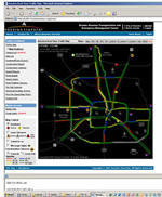
For traveler safety and convenience, many DOTs view providing information to the traveling public as a key part of their mission. The rise and continued improvement of ATIS has enabled DOTs to communicate with the public in new and innovative ways during incidents. Table 3-1 presents the types of ATIS used during incidents by jurisdictions interviewed for this study. Managing a planned special event has many of the characteristics of an incident from the standpoint of impact on transportation except that it is known in advance and, consequently, use of assets such as ATIS can be planned ahead of time.
| Jurisdiction | ATIS Technologies Used |
|---|---|
| Colorado DOT | VMS, HAR, website, 511 |
| Florida DOT, District 5 | VMS, 511, website, wireless devices, radio and television media |
| Maricopa County DOT | Partners with Arizona DOT on use of VMS, 511, and website |
| Nebraska DOT | VMS, 511, website, radio and television media |
| Oregon DOT | 511, extensive website, radio and television media including cable TV, HAR, VMS, developing application to send information to wireless devices |
| Texas DOT | HAR, VMS, website, wireless devices, radio and television media, e-mail alerts |
| Wisconsin DOT | Extensive HAR, VMS, radio and television media, website, telephone ATIS Service>br> (800-ROADWIS) |

DOTs work closely with state police, sheriff departments, and highway patrol during an incident and, to a lesser extent, during delivery of information to travelers. In some jurisdictions, local law enforcement and the DOT jointly fund and operate traveler information services, such as 511 telephone systems. Law enforcement, often the first responder on the scene of an incident, is the source of much information about new incidents which is often obtained by the DOT through monitoring police communications. With most DOTs who were interviewed reporting the use of Unified Incident Command during an incident, interdepartmental and interjurisdictional coordination appears to be in place.
Over the last decade a general approach to implementation of ATIS by transportation agencies has been established. The approach is illustrated by Figure 3-1, an ATIS process map, starting on the left with data collection, going through data processing and fusion, and ultimately resulting in information dissemination on the right. The gray rectangles in Figure 3-1 represent processes, and green rectangles represent products (every process must create a product). Non-italicized bullets represent the type of data or information, while bullets in italics identify the device or method of information dissemination.
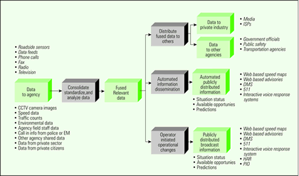
Figure 3-1. Process Map of Advanced Traveler Information Systems
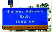
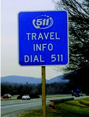 While the process depicted is fairly simplistic, the effectiveness of traveler information systems is not without challenges, which vary from place to place. Moreover, how well an ATIS performs has implications for its use in management of incidents or planned special events. A couple of examples illustrate some of the challenges. Telecommunications is one area, including interference in radio transmission which is known to cause problems with the use of highway advisory radio (sidebar). Another area of concern is interjurisdictional coordination. Traveler information systems are typically deployed for a given jurisdiction, such as a state or metropolitan area, and that in turn presents a problem for using ATIS for an incident that crosses jurisdictional boundaries. For example, 511 systems have not yet achieved full market penetration. 511 systems may not exist in neighboring states or, when they do, they may not be interoperable. This is a problem reported by some rural states, who wish to share winter weather information across state lines. For example, while Nebraska's 511 system can broadcast adverse winter road condition information within its borders, travelers driving from Wyoming or Colorado are often not able to get that information in time and may become stranded until the storm passes.
ATIS will continue to evolve and improve, and with time many technical and operational problems will be resolved. Nevertheless, ATIS today are important assets that transportation agencies are using for effective management of normal incidents and special events in many locations.
Traveler Information During Disasters: Five Case Studies
While transportation incidents are standard occurrences for agencies, disasters are significantly more complex and beyond normal emergency operations. Five disasters occurring without notice and impacting the transportation system served as case studies to determine how information was communicated to the public and how ATIS played a role. Disasters result from natural or manmade causes and can occur in any location. The disaster case studies were chosen to reflect various characteristics and are summarized in Table 3-2.
Dissemination of information about travel conditions to the public took two principal forms: through ATIS and through the media (radio and television).
| HIGHWAY ADVISORY RADIO |
|
Contributing to the problems with HAR is the fact that it is licensed as a secondary user under the guidelines established by the Federal Communications Commission (FCC), which means HAR transmission cannot interfere with primary users such as commercial broadcast stations. In addition, the FCC limits antenna height to approximately fifty feet, which limits its broadcast quality. Deployment in rural or suburban areas tends to be more successful than in urban areas, where structural interference is a problem. |
 In a small pilot project at the Phoenix International Raceway held during the spring 2005 NASCAR races, Maricopa County DOT (MCDOT) rented additional portable HAR units from a private vendor. The goal was to disseminate different messages to both incoming and outgoing traffic throughout the course of the weekend events. The HARs performed well in testing, but once the event began, MCDOT found that the HARs became inoperable due to radio interference from the sheer number of communications devices operating at the same time in the area. Interference came from radio communication being used by radio and television stations, by internal communications of the Raceway and public agencies, and by increased use of commercial radio by travelers, causing the HAR to be unsuccessful.
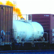
| Characteristics | South Salt Lake City, UT: Leaking rail tank car near I-15 & I-80. |
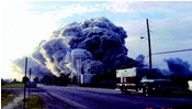
Rockdale County, GA: Warehouse fire involving chlorine product near I-20. |
San Diego County and City, CA: Major wildfire known as Cedar Fire. |
Clark County, NV: Snow avalanches in winter resort area and flood in Moapa Valley. |
Seattle/Olympia WA: Nisqually Earthquake [Magnitude 6.8] in Puget Sound Area. |
|---|---|---|---|---|---|
| Date | March 2005 | May 2004 | October 2003 | January 2005 | February 2001 |
| Relative scope and event context | Very localized. Urbanized area. ITS assets in event vicinity. | Fairly localized. Mixed suburban and rural area. No ITS assets in event vicinity. | Fire in large portion of County and some parts of City. Included uninhabited areas, small towns, and suburban neighborhoods. Some ITS assets near city limits. | Separate events involving two small communities, each reached by state highways in rural areas. No ITS assets in vicinity of either event. | Multi-county urban, suburban, and rural areas damaged. Many transportation jurisdictions affected. Some ITS assets on urban freeways. |
| Duration and disruption | 14-hour Interstate closure on all lanes. Minimal traffic impact due to Sunday occurrence. Resolved before Monday rush hour. | 35 hours of intermittent freeway closures. Three rush-hours affected. Traffic detoured around 20 miles of I-20. | 120 hours for acute phase of fire. Uncertainty about path of fire created potential for unanticipated rush hour closures on major freeways. | Over 60 hours. Closures on secondary highways only--no rush hours affected. Winter resort area inaccessible due to road closure. | Earthquake less than a minute. Acute consequence for 2 days. Many weeks of repairs, with closures exacerbating freeway congestion. |
| Special features of disaster event | Lack of accurate information about contents of leaking rail tank car prolonged closure. No transportation infrastructure damage. | Long-lasting fire continuously generating smoke plume downwind over or alongside the freeway. No transportation infrastructure damage. | Rapid and unpredictable wildfire due to wind conditions. Difficult to provide accurate information. Scattered transportation infrastructure damage. | County and NDOT assets had to be distributed between two events, distant from each other. | Damage less than immediately assumed. Transportation infrastructure damage, including bridges, in several counties. |
| Primary traveler and evacuee information needs | That freeways were closed in both directions for short stretch. That people in nearby neighborhoods should evacuate until further notice. | That freeway was closed in both directions at times. That plume contents irritating to skin and lungs. That people in nearby town of Conyers should evacuate. | That state and county roads were closed and opened as fire moved around. That orders to evacuate were based on immediate danger. That evacuation routes were limited. | That roadway cleanup and repair were needed in many locations. That events created personal risk in some areas so evacuation was prudent. That specific state roads were closed due to risk from event. | That there were several short term bridge/road closures for assessment or quick repair. That some road closures were prolonged and detours were necessary. |
| Disaster-Related Road Closure and Detour Information on Georgia DOT's Website and Phone System |
|
|
 Even though Interstate 20 carries a high volume of commuter traffic into Atlanta from the east as well as heavy east-west truck traffic, the site of the chemical fire adjacent to I-20 was beyond the range of GDOT's traffic surveillance and detection equipment. Nevertheless, the absence of automated data gathering near the disaster site did not hinder GDOT's ability to provide information by telephone to travelers. During the industrial fire, road information was relayed by GDOT's HERO and maintenance units participating in traffic management in the vicinity of the disaster. That information, in turn, was available on a 24-hour basis from live operators on GDOT's Star-DOT (*DOT) system. In addition, the GDOT Navigator website was able to carry the full description of the detour routes when I-20 was closed, although its maps of real time traffic congestion did not extend out as far as Rockdale County where the disaster was occurring.
Role of ATIS. ATIS technologies were used by all the DOTs to various degrees to provide information on road closures and other details about the disaster. Technologies including VMS, websites, free telephone services (511 or 1-800) with a frequently updated recorded message about traffic conditions and road closure information, and in one case HAR. Table 3-3 summarizes the ATIS used at each site.
Fixed VMS were used in all sites, but typically only existed for Interstate and other state highways in highly urbanized areas. For example, for the industrial fire in Rockdale County, Georgia, VMS in Atlanta alerted travelers to the closure of I-20, but there were no VMS on I-20 for travelers from the east. Portable VMS were available on the state roads in the rural Nevada county and were particularly useful for the San Diego County fire, because the locations of road closures were constantly changing as the fire moved through the county.
All five sites had toll-free telephone numbers, which can provide more detailed information than VMS. California, Washington and Nevada had statewide road condition telephone numbers with recorded information on specific routes. Clark County, Utah, also had a local citizen information line with recorded information about the disaster, but callers often encountered busy signals due to the large call volumes during the event. Utah was the only site to have a 511 telephone system in place at the time of its disaster, and its automated messages reported on closures and estimated minutes of delay on specific routes.
| Disaster Location | Toll-Free Telephone | Website | Variable Message Signs Fixed |
Variable Message Signs Portable |
Highway Advisory Radio |
|---|---|---|---|---|---|
| South Salt Lake City, UT (2005) | X | X | X | ||
| Rockdale County, GA (2004) | X * | X | X | X | |
| San Diego County and City, CA (2003) | X | X | X | X | |
| Clark County, NV (2005) | X | X | X | X | |
| Seattle/Olympia, WA (2001) | X | X | X | X | X |
Clark County, Utah, also had a local citizen information line with recorded information about the disaster, but callers often encountered busy signals due to the large call volumes during the event. Utah was the only site to have a 511 telephone system in place at the time of its disaster, and its automated messages reported on closures and estimated minutes of delay on specific routes.
| Recognition of Circumstances As Not Normal |
|
The Clark County (Nevada) Emergency Manager was aware of the avalanche death in the Mt. Charleston area, and the continuing avalanche danger, but it was not until the additional danger of flooding became known that the situation was recognized as exceptional. The overall situation called for active coordination of the resources and information. He activated the Clark County EOC, an action that had been done in the past for planned events (such as the New Year's Eve celebration along The Strip) but had not been done for an actual unplanned emergency. He declared the situation a county emergency, because it appeared that state resources would probably be necessary to supplement some of the Clark County activities. The number of simultaneous emergencies in Clark County created a situation beyond normal response capabilities, and special efforts were needed. This created a very heavy demand on all the agencies in that area, including the volunteer fire department, the Clark County Public Works Department, the Nevada Highway Patrol, and the American Red Cross. Given the scale of the emergency, NDOT and the NHP, as state agencies, had to split their resources to cover both areas, as did the Clark County Public Works Department. The Clark County Emergency Manager reported that, in all, twenty-two different agencies were involved in the response. |
All five sites had one or more websites with travel information. For example, in San Diego the California Department of Transportation (Caltrans) website had a special link to a list of road closures and also posted the computer assisted dispatch (CAD) log from the California Highway Patrol. The Georgia DOT Navigator website posted the detailed detour information, and on Utah DOT's CommuterLink website VMS messages could be viewed along with camera images and textual descriptions of road conditions around the disaster site.
HAR was used during only one of the disaster events—the earthquake in the Seattle/Olympia area. The HAR message provided updated lists of closures, and could provide other details, such as the closure being due to inspection. Various reasons appear to contribute to HAR not being used during the other disaster events, and some DOT staff do not view them as reliable technologies. Utah DOT's HAR is a case in point; it was not working the day of the event and, in addition, tends to have poor signal in the Valley when it is operational.
Role of Media. The media, and in particular the television news broadcasts, provided the most information overall about each disaster. The media actively sought information on the events, and all the DOTs reported that they counted on the media to get the road closure information out and, therefore, facilitated the media's access to such information. For example, all the sites had commercial traffic radio programs that typically got their information directly from the DOT's Traffic Management Centers (TMC). Given their metropolitan focus, traffic radio programs probably were least useful for the rural events, such as the flooding and avalanches in Clark County, Nevada, although they were helpful for providing information on which roads were experiencing flooding in the urbanized areas in the Las Vegas Valley at the same time.
Most agencies involved in the disaster response had a public information officer (PIO) who was designated to be the contact for the media for the disaster event. In two of the cases, Utah and Georgia, an area at some distance from the incident command post was designated for the media to congregate and get information from the PIOs and from time to time the incident commander, who would provide a more general overview of the status of the event and answer questions. For the other three cases, the county or state emergency management agency, or both, activated an emergency operations center (EOC) for the purpose of coordinating activities and information across the agencies participating in the response. These EOCs included a joint information center (JIC) where the individual agency PIOs would provide information from their agency's field personnel to be combined with information from other agencies. Information for release to the media would be developed by the communications staff of the emergency management agency, with the purpose being to produce information that was consistent as well as comprehensive. The press briefings provided in this manner resulted in many media representatives all getting the same information at the same time.
Dissemination of Evacuation Information. Evacuation of residents in areas threatened by the event occurred at four of the sites, typically by law enforcement officers going on foot or in vehicles with public address systems to tell residents in the specified areas of the need to evacuate. In some cases, such as the San Diego County wildfire, the order to evacuate also had to indicate what route would be safe. The information about what areas had been evacuated then became part of the information provided to the media who informed the public so people would know what areas were closed or what areas had been reopened.
| Experience with One Disaster Leads to New Procedures at Utah DOT |
|
|
 UDOT wasn't as directly involved in the response to the leaking railcar in the early morning hours as they would have been had it occurred on the highway. Being somewhat “out of the loop” when the adjacent highway had to be closed limited UDOT's ability to estimate when the highway would be ready to use again. Since the incident occurred on a Sunday, staffing at UDOT Traffic Operations Center (TOC) was light, and those on duty tended to be the least experienced. As a result, escalation of the TOC's response was delayed, and incident response planning for a prolonged closure into the Monday morning commute period did not begin until more senior staff arrived in the early evening. The experience with the disaster led UDOT to develop threshold criteria for “non-normal” incidents that will enable TOC staff on duty to make decisions in a more timely fashion about when management needs to be notified and additional resources applied. UDOT felt that the criteria will help the operations people do their job of dealing with the details of information about the incident and the highway impacts, while at the same time people outside the control room can look at the bigger picture and longer-term impacts and think about what needs to be done.
In each of the rural settlements in Clark County, Nevada, where evacuation was necessary, local information dissemination systems in the form of phone trees were used to get information about the need to evacuate and the location of shelters to as many residents as possible. In the communities affected by the flooding, trained volunteers also were used to follow up the phone tree notifications, by going to certain residences in order to ensure that everyone had received the information and to see if there were people who needed assistance to evacuate.
| Alerting San Diego Motorists to the Danger of Rapidly Spreading Wildfire |
|
|
 The Caltrans Traffic Management Team (TMT) was the front line for the task of getting signs along the highways to alert motorists to closures. They took care of the messages on the limited number of fixed VMS. Portable message signs proved more useful. Using their six trucks with affixed VMS and 16 trailers with portable VMS, the TMT would go to where they were directed to put up a sign about a road closure. There was usually a law enforcement officer already at that point to get the traffic stopped. This was followed up by the Caltrans maintenance units placing some sort of barrier across the road. The TMTs were very busy changing the portable signs to new locations as the fire moved about. The TMTs also tried to assist with the county roads, because there are many more of them, but couldn't do much given the demands on them for the state roads. For the county, closures were established first with a patrol car and an officer, and the public works department provided barriers. The information about the status of these closures was passed on to the field supervisors to provide to the Emergency Operations Center who got the word out to the media and general public.
A telephone-based emergency notification system, known as Reverse 911®, can be used to automatically dial a specified set of telephone numbers in order to deliver a pre-recorded message when the phone is answered. This type of notification system was used in South Salt Lake City along with police officers going house to house or along streets with loud speakers to tell people to evacuate.
| The Need for Traveler Information During the Recovery Phase |
|
|
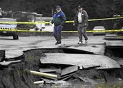 Earthquakes, such as Washington State's Nisqually, can impact transportation for weeks or months, leaving a visible legacy of the disaster and need for traveler information long after the emergency is over. In Olympia, the prolonged closure of the 4th Street Bridge made access to downtown Olympia difficult for commuters. In Seattle, the prolonged closure of the Magnolia viaduct made it necessary for residents to use a more complicated route to get to their neighborhood. Immediately after the earthquake, air traffic had to be curtailed significantly at the SeaTac airport because the FAA air traffic control tower was badly damaged. A terminal for Washington State Ferries that carries commuters back and forth across Puget Sound had to be closed for a day for repairs. While each instance of damage was manageable by itself, the disruptions occurring all at once compounded their impact on residents of the area and their need for information about how to get around.
Key Findings Related to Disaster Information Dissemination
Looking across all five of the disaster sites examined by the study team, the following general findings defined the current state of communication with the public during disasters and the potential role of ATIS.
- Prominence of the Media in Information Dissemination. It is the media, and not ATIS, that is currently viewed as the principal disseminators of information to the public during disasters. Agencies view the media as partners during an emergency, and the timely and reliable provision of information to the media could result in the news coverage of the event playing an important role in disseminating information that the agencies wanted the public to have, such as where highways and roads are closed or what areas are dangerous. Technology such as the Internet makes it easy for agency personnel such as public information officers to distribute each news update from a response agency to a large set of media contacts simultaneously.
- Awareness of ATIS Among Responders and the Public. Greater awareness or education about ATIS assets is needed among all parties involved in disaster planning and response. They need to understand the range of ATIS and their capabilities and how they can complement the media coverage of the disaster. Moreover, the traveling public may also need to be educated about ATIS as a source of information on travel during disasters, rather than or in addition to some of the other sources they may think to use.
- Joint Information Center for Coordinating Information to the Public. All the sites studied sooner or later instituted a process for bringing various pieces of information about the disaster together and synthesizing them for news briefings and dissemination on ATIS. The establishment of a joint information center (JIC) signals a formal structure for information dissemination that supports the Incident Command System. A JIC helps ensure delivery of consistent and accurate information regardless of the number of agencies that are involved.