Evaluation of Travel Time Methods to Support Mobility Performance Monitoring:
Blaine (Pacific Highway) (Page 1 of 3)
Final Site Report
April 2002
to
Office of Freight Mgt. and Operations
Federal Highway Administration
U.S. Department of Transportation
Washington, DC 20590
by
Battelle Memorial Institute
Border Crossing Freight Delay Data Collection and Analysis
FY 2001 Data Collection – Pacific Highway (Blaine Border) Crossing
Site Description
The Pacific Highway (Blaine Border) Crossing is the major truck border crossing linking western Washington state with the coastal mainland of British Columbia (BC). The border between Washington and BC is located on the 49th parallel and since it is defined by degrees of latitude north of the equator it does not correspond to any natural feature such as a river. Consequently, there is only an imaginary line demarcating the border and no bridge or toll facility. The border crossing is the mandatory crossing point for all trucks traveling north on I-5 towards BC and south on BC route 99 towards Washington State. The Blaine crossing is located about one mile to the east of the auto crossing. The Blaine Border Crossing is the gateway that trucks traveling from Seattle north to Vancouver or Vancouver south to Seattle and beyond use. Trucks traveling north on I-5 must exit the Interstate at state route 543, cross the border about a mile to the north then continue north on BC route 15 to BC route 914. On BC route 914, the trucks travel west to join the BC route 99, the major route north to Vancouver. Heading south the process is reversed. Figure 1 shows a map of the general region in Washington and British Columbia that provides access to the border.
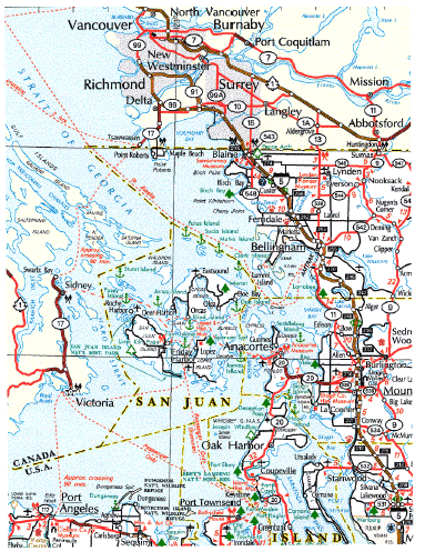
Figure 1. Area Map – Blaine Border Region.
Data collection activities took place at the Blaine Border Crossing on Tuesday through Thursday, July 10 through 12, 2001 for approximately 12 hours each day. The times of data collection were selected to correspond to those hours with the highest truck traffic flows and anticipated longest delays. The Blaine Border Crossing is open 24 hours a day, seven days a week.
Outbound (northbound) truck traffic traveling to Canada must exit I-5 at state route 543 and drive the approximately one mile north to the border. Route 543 is a two-lane road but trucks must use the shoulder when there are backups at the border crossing. There is a small duty free shop close to the crossing but it does not appear to be used by the trucks. Close to the border, the number of lanes expands to four to enable the vehicles to proceed to their respective Customs booth. Automobiles, pickups and vans curve slightly to the east to enter Canadian Customs while buses are diverted further east to enter their primary inspection area. Trucks are diverted furthest to the east past the truck Customs booths. Ordinarily, the Canadians have one booth operating but usually open a second when traffic conditions warrant. Trucks are either released from primary inspection or must continue on to the secondary inspection facilities that are located to the north and east of the primary booths. At secondary inspection, trucks can undergo further papers checks and/or physical inspection at truck bays or in the parking area. All trucks regardless of whether or not they require secondary inspection then proceed north on BC route 15. This route provides two lanes of traffic in each direction.
Inbound (southbound) trucks traveling to the United States follow a similar pattern to outbound trucks. As they approach the border crossing, smaller vehicles curve slightly to the west and then proceed to the Customs booths while buses move just to the west of the small vehicles. Trucks turn sharply westward to reach the truck primary inspection booths. A number of trucks stop at the Canadian duty free shop, which is about a quarter-mile north of the border, and then rejoin the border crossing traffic after the trucks have diverted from the rest of the traffic and are proceeding towards the booths.
Some trucks stop at the small parking lot located just north of the point where the trucks turn towards the primary booths in order to check their paper work and visit the brokers located just south of the border on the east side of the road. There are currently spaces for 14 trucks but a number of additional spaces will be available this fall to the west of the parking lot. During daylight hours, two booths are usually open with one booth being open throughout the night. When traffic backs up in a outbound direction, it occupies the right lane of BC route 15. As is the case at Canadian Customs, if a truck requires additional inspection, it is diverted to the secondary inspection facility located to the south of the primary facility. Trucks exiting the secondary facility rejoin those trucks that have only been required to pass through the primary inspection booths. All trucks then merge onto State route 543 and proceed south towards I-5. Figure 2 shows an aerial view of the Canadian and American truck Customs area as well as the approach roads leading to the border.
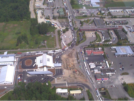
Figure 2. Blaine Border Crossing (looking North).
Data Collection Process
For this study, two data collection locations were used in each direction. The "number 1" locations were located to the north or south of where the truck queues were anticipated to form due to backups at the primary Customs location. The "number 2" location was immediately after the primary inspection booths. For consistency among all border crossings visited as part of the overall project, the data collection positions were distinguished by whether the trucks were traveling out of or into the United States. For the Blaine border crossing, outbound corresponded to northbound and inbound to southbound. Figure 3 shows the approximate locations of the data collection points both for the United States and Canada. The figure shows three outbound locations designated OB 1A, 1B and 1C. These locations represent each of the data collection points in the outbound direction. The OB-1 data collector shifted locations as the outbound truck queue backed up along SR 543. OB-1A was located on the south side of a truck parking area about 0.4 miles from the Canadian primary inspection booths. OB-2 was located about 0.7 of a mile from the custom booths along SR 543 and OB-1C about 1.1 miles from the custom booths on the ramp leading to I-5. Figures 4 and 5 show the location of OB-1C and OB-2 data collection points respectively. The Inbound 1 (IB-1) position was located at the north end of a truck parking area about 0.5 miles from the US primary truck custom inspection booths. This data collection point was located north of the Duty Free Shop and the parking lot with the 14 truck parking spaces used by trucks visiting brokers. The inbound 2 (IB-2) data collection point was located adjacent to the American Customs booths. Figure 6 shows the location of the IB-2 data collection point. The IB-1 data collector moved on one occasion when the queue extended past the position shown on the map as IB-1. However, when the data collector finally drove into the new data collection location along the road, the queue had dissipated and she returned to the original collection point.
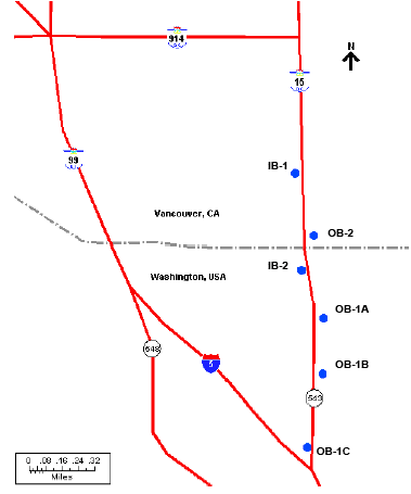
Figure 3. Sampling Sites at the Blaine Border Crossing.
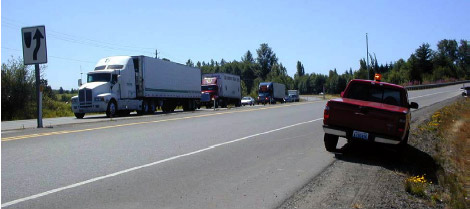
Figure 4. OB–1C.
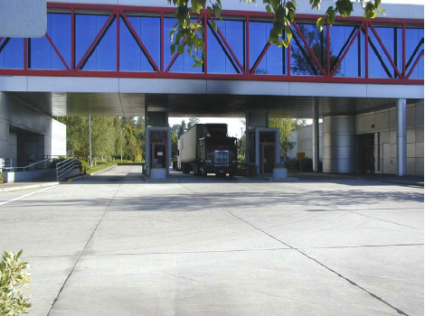
Figure 5. OB–2.
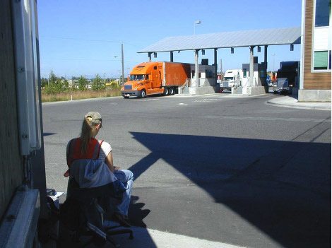
Figure 6. IB–2.
Each data collector would use a handheld computer to record partial license plate information of all commercial vehicles that passed their location. The computer would also store the time that each license plate was entered. The data from the two locations in each direction would be combined, allowing the determination of the travel time for each vehicle that was recorded at both locations.
For the data collection, the on-site team included four data collectors and one supervisor. The hours during which data were collected were selected to encompass the peak truck traffic period when delays would be most likely. They were selected from an examination of the available truck flow data and discussions with knowledgeable officials. Table 1 shows the data collection hours for each day during the site visit. Data collection extended about 12 hours and included the periods when the supervisor collected data during break periods and the 30-minute meal period.
| Date | Start | End |
|---|---|---|
| 7/10/01 | 8:00 am | 8:00 pm |
| 7/11/01 | 8:00 am | 8:00 pm |
| 7/12/01 | 7:00 am | 7:00 pm |
The arrangements that led to the data collection activities required a considerable number of phone calls, e-mail correspondence, and a site visit. A meeting was held at the Blaine Border Crossing with representatives of Canadian and U.S. Immigration, Canadian and U.S. Customs, the B.C. Ministry of Transportation, the Whatcom Council of Government, FHWA representatives, and Battelle. In addition, the Battelle representative toured the border area and potential data collection sites on both sides of the border with local officials.
Table 2 contains a list of the individuals who were contacted and their telephone and e-mail information. Future data collection for this project should be able to be organized and authorized more easily. However, any new project would require additional time to explain the data collection objectives to the involved parties and gain their approval.
| Contact | Agency | Phone/Fax | |
|---|---|---|---|
| Gary Baker Customs Supervisor |
Canada Customs | 604-538-3607 604-538-8961 (fax) |
Gary.Baker@ms.rc.gc.ca |
| Jay Brandt Assistant Port Director |
U.S. Customs | 360-332-4656 360-332-4701 (fax) |
J.R.Brandt@Customs.treas.gov |
| Mike Brower Transportation Mobility Engineer |
FHWA | 360-753-9550) 360-753-9889 (fax) |
Michael.Brower@fhwa.dot.gov |
| Bruce Bruner Port Director |
U.S. Immigration | 360-332-6091 360-332-3747 (fax) |
Bruce.M.Bruner@usdoj.gov |
| Bridgette Canil Intelligent Transportation System Engineer |
BC Ministry of Transportation | 604-660-8239 604-660-2181 |
Bridgid.canil@gems.5.gov.bc.ca |
| Hugh Conroy Project Manager |
Whatcom Council of Governments | 360-676-6974 360-738-6232 (fax) |
Hugh@wcog.org |
| Ken Moyes Shift Superintendent |
Canadian Immigration | 604-535-5450 604-541-5621 |
Ken.Seebach@ccra-adrc.gc.ca |