Grant Proposal for U.S. Department of Transportation Advance Transportation and Congestion Management Technologies Deployment (NOFO 693JJ317NF0001): Volume 1 – Technical Application
6.0 PROJECT IMPLEMENTATION/SOLUTIONS
6.1 Traffic Congestion Management Solutions
6.1.1 Adaptive Signal Control System
Adaptive traffic control systems is the most requested type of "Smart" technology in Chula Vista according to a recent survey conducted by the consultant that is developing the City's Smart City Strategic Action Plan.
Given this information, and our knowledge of the City network, we are proposing an expansion to our 28-signal adaptive traffic control system (located on the eastern part of the City) by enhancing over 50 traffic signals with adaptive capabilities. These systems will be deployed on the H Street, Broadway, Third Avenue, and Main Street corridors. These corridors are gateways to the City and will carry some of the most impacted bus routes in the county. In addition, signalized intersections that interact with railroad crossings on E Street, H Street, and Palomar Street will also be outfitted with adaptive traffic control systems to reduce congestion, provide immediate signal recovery following a railroad pre-emption event, and enhance safety at these intersections.
In line with our "Climate Action Plans," these improvements will result in a tremendous reduction in fuel consumption and vehicle emissions that lead to high ozone levels. According to recent adaptive traffic control systems studies in San Diego, CA and Farmington, NM, adaptive traffic control systems have been proven to reduce vehicle emissions by up to 30 percent and travel times by over 40 percent.6
6.1.2 Signal Performance Measures
Through the installation of new Advanced Transportation Controllers (ATC), and using existing vehicle detection, the City will use an Automated Traffic Signal Performance Measurement System (ATSPMs) to collect and display high-resolution data that will serve as the framework for improved signal timing, enhanced safety, reduced fuel consumption, and better regularly optimized, traffic flow becomes more predictable and orderly, minimizing traffic congestion, and as a result improving safety at intersections. Traffic signal timing improvements using high-resolution data have accounted for reductions of 10 to 50 percent in the number of severe crashes at intersections and significant reductions in delays and travel times.
6.1.3 Advanced Traveler Information Systems

Transportation system users currently rely on the radio and various apps that provide travel time and general incident-related data. An enhanced system where drivers, cyclists, and pedestrians can make better commuting choices based on real-time information is key in order to create an environment where users are able to make decisions which result in a safer commute, reduction in GHG emissions and travel times.
In order to accomplish this objective, the City proposes the installation of a number of data collection devices throughout the City that will link to various CMS which will provide the user with alternate routes during incidents on the road. These signs will be placed at strategic locations on major corridors such as H Street, Main Street, Telegraph Canyon Road, Fourth Avenue, near the I-5, I-805, SR-125, and SR-54 in order to facilitate the safe and efficient flow of traffic during traffic incidents, special events, and/or emergency response events.
As most major cities, the City of Chula Vista encounters traffic challenges near the entrance/exit to major freeways. The CMS signs would draw travel, congestions, speed, data from the Wi-Fi/Bluetooth data collection devices and automatically post appropriate messages based on a pre-approved library of messages. This information will allow system users to make alternate route choices which will result in less congestion, faster travel times, and a reduction in the number of crashes that may occur due to the high traffic queues and driver frustration due to long delays.
In addition, given the location and weather characteristics of southern California, the City of Chula Vista has been susceptible to wildfires over the years. The most recent large wildfire took place in 2007 when thousands of residents were ordered to evacuate the eastern part of the City. The availability of the proposed CMS signs will allow City staff to implement appropriate messages to support these large evacuations and create a safer and more efficient environment for the community in these extremely hectic and uncertain moments.
CMS signs will also assist our Police Department in the safer and more efficient implementation of traffic control for the numerous events that take place at the Mattress Firm Amphitheater off Main Street. With a capacity of over 20,000 people, the amphitheater is home to dozens of musical acts, school graduations and other special events throughout the year. The proposed CMS signs will provide valuable information to drivers for a safer and more comfortable experience as they navigate the City's only reversible lane street configuration (Main Street) on their way to/from the amphitheater.
6.2 Mass Transit Solutions
6.2.1 Bus Rapid Transit Transportation System
The City seeks to deploy the following systems within the bus transit network to assist public transportation system operators or other shared mobility entities in managing and optimizing the provision of public transportation and mobility services:
6.2.1.1 Bus Rapid Transit Adaptive Signal Control
Adaptive signal control technology will be deployed to improve the mass transit network along four high frequency bus transit corridors in the City of Chula Vista. The deployment of an advance transportation management system such as adaptive signal control technology will provide an advance public transportation system that enhances reliability of transit service and reducing congestion. This endeavor will encompass regional objectives and goals that benefit the region in delivering an efficient bus rapid transit system.
The proposed scope of work includes installing new Advance Transportation Controllers(ATC) with adaptive signal control at the intersections and a new central system. These improvements will provide the operations needed to dynamically change the timing of the signals to achieve optimum performance of the bus rapid corridors.
The ability of a signal to adjust signal timing in real-time or in advance of bus priority activation has always been a challenge in controlling signals with bus priority. Commonly, signals would respond to a bus priority call by either extending the green or truncating vehicles phases to ensure buses remain on schedule by advancing through the intersection. The challenge that faces operators is to have a system that systematically balances the timing between vehicles, pedestrians, and buses by holistically creating or adjusting timing along a corridor of signals. The enhanced capabilities of an adaptive system provide the tools and features not typically found in basic traffic signal controllers. Bus priority operations can be enhanced by an adaptive system in two major ways: (1) improve recovery time of signals in resuming normal operations following a bus priority call, and (2) provide system triggers which allows operators to dynamically change signal timing along an entire network of signals.
Due to the priority given to buses at signals, this typical disrupts normal operations that can affect vehicle progression and green time. The adaptive system would assist in improving the time required for a signal to resume normal operations after a bus priority activation. This can be accomplished by the system by changing offsets or cycle times that ensure coordination or minimum phase green times is maintained at the intersection and/or holistically within the network. The adaptive system also provides the opportunity to set system triggers which allows intersections to communicate with adjacent signals to determine the appropriate timing plan or provide downstream advanced priority operations. Deploying an adaptive system with these technological capabilities provides the ability to more effectively manage traffic and create a more efficient, reliable signal system for bus rapid transit.
6.2.1.2 Bus Traffic Light Information System
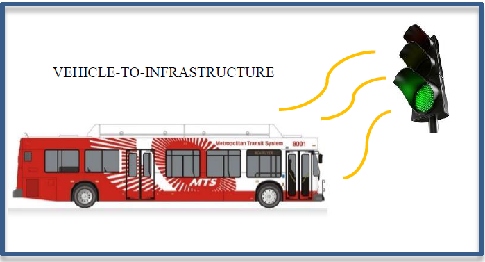
To further enhance the reliability and operability of the bus transit network, the City seeks to deploy a Traffic Light Information System which provides a dashboard display of signal timing information to bus operators. This technology is most notably utilized as a vehicle-to-infrastructure communication system that provides vehicles an on-board display of remaining green time information. Current practice shows its application towards general traffic vehicles, however, this technology can be very useful if applied towards mass transit buses.
The City seeks to implement this technology along the four bus rapid transit corridors. Transmission of signal timing information and communication between buses with traffic signals will be accomplished through the installation of advanced transportation controllers at each of the intersections. The deployment of this technology has most recently been seen in the City of Las Vegas and City of Palo Alto. The City of Chula Vista would like to showcase once again the potential of this technology and how it can be applied towards the mass transit system. Bus operators would essentially gain similar benefits from this technology. Traffic Information Systems would communicate with the bus and receive real-time information from the advanced transportation controllers. The bus would display on its driver instrument cluster the time remaining until the signal changes. The additional information would assist the operator in making better driving decisions when accelerating or decelerating through an intersection. The on-board information can also be used to help optimize routes and provide an avenue for bus operators and traffic signal engineers to work together with the data shared. This will enable cross jurisdictional coordination and ultimately improve transit priority operations.
6.2.1.3 Wi-Fi Enabled Bus Stops
To encourage the use and ridership of mass transit, the City seeks to offer its users free Wi-Fi enabled bus stops through its comprehensive communication network. In the age of "Internet-of-Things", also known as IoT, the ability for devices to connect to the internet has shown boundless opportunities for the transportation technology environment and its users. The City would leverage IoT devices to improve rider experience by achieving two objectives: (1) provide accessibility to an electronic paying system at bus stops and (2) increase accessibility to free public Wi-Fi. The City believes deploying these measures will help to improve the mass transit experience and ultimately increase public usage.
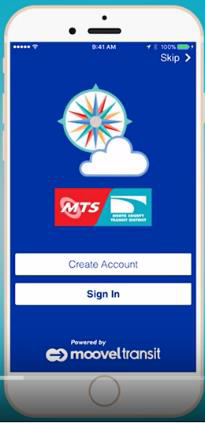
One of the challenges that faces mass transit is to provide an electronic paying system that is quick and easy to use. With the modernization of smart phones, users can pay electronically using the Wi-Fi provided at bus stops for bus fares. This method of payment can help to streamline fare collections by expediting the payment process with a quick scan of personal phones. This will help to reduce the time between the loading and unloading of passengers at bus stops and help better time efficiency of the transit network. Payment-by-phone can be accomplished today through either a transit agency app or third-party vendor (i.e. Apply Pay, Samsung Pay, Masterpass, etc.) Currently, the MTS agency is utilizing a smart card paying system called the "Compass Cloud".
The Compass Cloud is a mobile ticketing app which enables users to purchases fare tickets or passes and use immediately through their personal smart phones. The Compass Cloud is currently accepted everywhere in the San Diego Metropolitan Area and is widely used. The opportunity to provide added accessibility to the internet through Wi-Fi-equipped bus stops will help to encourage the use of an electronic paying system that is available today.
A free public Wi-Fi will also help to assist the population of underprivileged users which may not have access to the internet or is limited by their service provided. Users can rest assure their data rates will not be affected when connecting to the free public Wi-Fi service while using the Compass Cloud. The free internet service will help to promote a more user friendly, accessible public transportation system that enhances rider experience. Users will also benefit from internet access to help perform internet driven activities that are vital in today's modern world. This includes access to internet services from health care, to education, to communication with family or friends, to professional networking. The added convenience of a free public Wi-Fi will help to ease idle time of passengers and also provide increased connectivity to vital public services and communication.
Implementation of Wi-Fi services at City bus stops would be accomplished in cooperation with MTS. Existing bus stops will be retrofitted with communication equipment to establish Wi-Fi connectivity. The installation would include a router, modem or wireless radio (when connecting to a traffic signal), and standalone power supply. Internet access will be provided through a third-party service provider on a dedicated, managed network requiring user registration. This process will help to manage network capacity and provide data to the City and Transit Operators regarding the usage of the system.
6.2.1.4 Global Positioning System
Advance transit operations will be achieved through the deployment of a Global Positioning System (GPS) technology. The GPS enabled system will provide enhanced Transit Signal Priority (TSP) operations that boost the efficiency of the transit system in reducing transit travel time. The TSP operations, coupled with GPS, would be deployed along the bus rapid corridors. By implementing TSP technology, transit travel times are expected to be reduced up to 10 percent during peak hours.7
The GPS TSP will also serve to help increase transit efficiency by streamlining data acquisition and analysis of bus priority operations. The proposed technology also provides a long-term solution in maintaining system performance of the transit network.
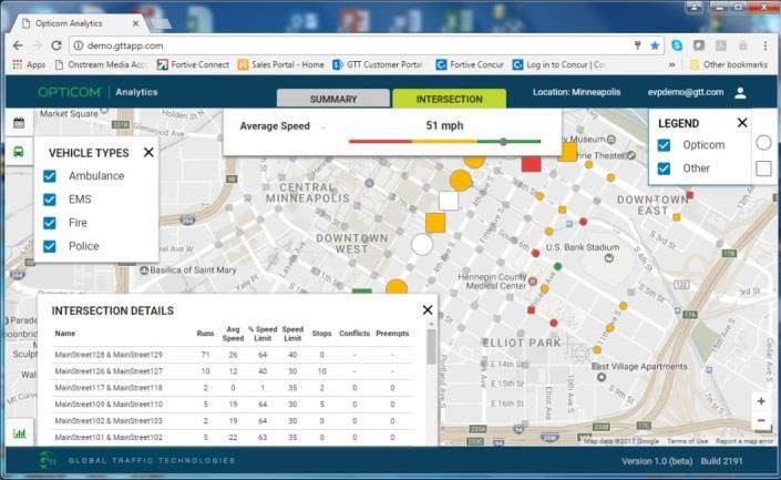
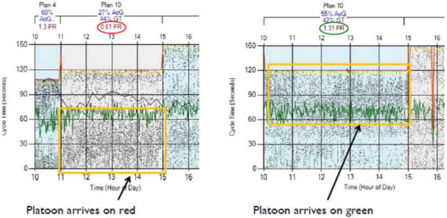
By implementing a GPS based bus rapid system, traffic engineers can systematically record and track bus priority operations at every intersection. This information can be viewed live or historically through a GPS management system. The system would provide information regarding vehicle run times, speed, and priority activation calls. The data collected will help system operators to help optimize bus routes and identify trouble spots within the City. Modern GSP TSP systems like Global Traffic Technologies (GTT) systems are equipped with management tools and data analytic features that help to optimize transit operations by collecting and disseminating data into user-friendly graphs, charts, and interactive maps.
Several examples include displaying map data regarding vehicle speeds at intersections, number of stops, and travel time runs. The City believes the proposed technology will help to advance the collection of data that is necessary to maintaining bus serviceability and reliability.
The deployment of a GPS bus rapid system would require equipping the existing traffic signal cabinets with GPS detector cards and antennas and retrofitting MTS buses with new GPS transmitters. The scope of work would also include programming and system integration of GPS devices, software, and installation of a new server or cloud-based operating system.
6.3 Traffic & Public Safety-Related Solutions
6.3.1 Intersection Safety
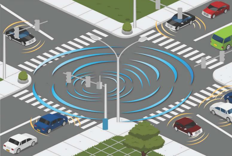
In January 2017, USDOT named Chula Vista, in partnership with SANDAG and Caltrans, as one of ten Autonomous Vehicle Proving Ground sites in the nation. The City understands that with this designation, one of the expectations is that we welcome the use of advanced technology for transportation applications. We completely embrace that expectation and, as part of this grant, the City will establish a Smart Corridor on the entire length of Broadway (4 miles) to help address a number of crash hot spots and to set a path for a replicable system that can be deployed in other parts of our city and/or anywhere in the world. Having received the Federal designation as an Autonomous Vehicle Proving Ground, we know that we must interact with vehicles in a different way. Using the skill of the international Standards Development Organizations (SDO), the City will instrument the corridor with advanced digital infrastructure at each signalized intersection. This infrastructure will deliver precise signal operations data to these vehicles including the exact geometry of the intersection, and signal phase and timing information.
Non-autonomous vehicles, on this corridor and throughout the city, will also be able to receive information from our traffic signals via a Smartphone app or onboard displays which are included in a number of latemodel vehicles. These vehicles will be able to survey our traffic signal 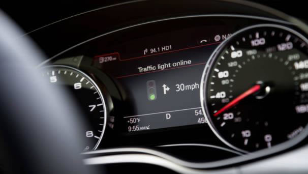 infrastructure and view the Signal Phasing and Timing (SPaT) information as they approach a signalized intersection. This technology provides drivers an enhanced level of service that can result in better decision making and a reduction in red light running.
In addition, through the installation of new Advanced Transportation Controller, and using existing vehicle detection, the City will use an Automated Traffic Signal Performance Measurement System (ATSPMs) to collect and display highresolution data that will serve as the framework for improved signal timing, enhanced safety, reduced fuel consumption, and better use of resources in our city. As the signal timing is regularly optimized, traffic flow becomes more predictable and orderly, minimizing traffic congestion, and as result improving safety at intersections. Traffic signal timing improvements using high-resolution data have accounted for reductions of 10 to 50 percent in the number of severe crashes at intersections.
All of the data that will be available through the installation of new sensors, traffic signal controllers, and traffic monitoring systems will provide a more complete set of information for the City's Data-Driven Safety Analysis (DDSA) efforts.
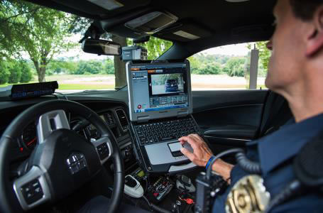
6.3.2 Red Light Running Prevention & Analytics Using CCTV's
Closed Circuit Television (CCTV) cameras have become more advanced and affordable in recent years. As a result, Chula Vista has adopted a policy of installing a CCTV camera at every new traffic signal as part of its Capital Improvements Program (CIP) and as a requirement to land developers. The purpose of these cameras is to assist City staff in their traffic monitoring efforts and make best use of available time and resources.
A relatively untapped function of these cameras is their sophisticated built-in analytics systems. Given that most of these ITS cameras were born out of the police/security surveillance and/or military world, they are excellent at tracking vehicles. Through this grant, the City will install dozens of CCTV at strategic locations to capture and analyze red light running patterns at signalized intersections. Using the cameras' advanced analytics; we will be able to determine when/where vehicles are running red lights (or speeding) so that our police department can focus their enforcement efforts. As we struggle with limited staff and budgets, it is critical that we use technology to enhance safety AND maximize the return on our investments.
6.3.3 GPS-Enabled Emergency Fire Response System
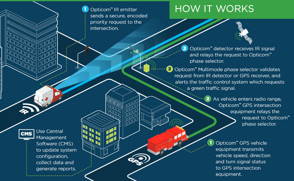
The City's substandard performance in fire response time must be immediately addressed. With the worst fire response time in the state, Chula Vista's deployment of a citywide GPS-enabled emergency fire response system at all signalized intersections will make a significant impact and provide better and faster service to our citizens at the times when they are in need of immediate/critical assistance. GPS-enabled emergency response systems have improved fire/ambulance vehicles' response times by as much as 30 percent.8 Given the City's, roadway network, population density, and budget limitations for the addition of more fire stations and fire personnel, a GPS-enabled fire response system becomes a tremendous opportunity for the City to take advantage of a proven technology with a history of successful deployments throughout the country.
The deployment of this system would be extremely efficient as it would be completed in combination with the deployment of our proposed transit signal priority enhancements. Our new GPS-enabled system would repurpose some of our existing intersection infrared emergency vehicle preemption technology and allow us to implement a dual system (infrared & GPS) which would support our surrounding neighbors' fire/ambulance vehicles (still using infrared emitters) to provide aid to Chula Vista's Fire Department in times of need. The GPS-enabled system does not require line-of-sight and provides a less abrupt traffic signal pre-emption event which lead to the increased levels of performance and safety at intersections.
Using the same in-cabinet equipment as the transit signal priority system, we are able to provide a mutli-benefit system to our community and set a definite path for future freight priority applications as well (using low priority signal similar to transit signal priority).
6.3.4 Closed Circuit Television Cameras for Public Safety
As the city deploys CCTV cameras to support traffic monitoring and management efforts, we see an opportunity to support other City departments and provide superior levels of service to our community. As noted earlier, ITS CCTV cameras are essentially surveillance cameras that have been augmented to provide transportation-related analytics and, in some cases, ruggedized to survive more harsh outdoor environments.
The installation of high-definition ITS cameras will allow the traffic engineering branch to share video and information with our police, fire, and others in case of emergencies and/or for response to specific incidents or to support specific surveillance efforts. With new ITS cameras that can provide 360-degree views and also provide pan-tilt-zoom (PTZ) capabilities, modern cameras are able to serve many needs and requirements in one solution.
6.3.5 Intelligent Street Lighting for Public Safety
In recent years, the enhancements to street lighting systems have gone beyond the improvements in lighting and fixture technology; they have become a true intelligent and extremely valuable tool to support many other aspects of transportation, public safety, communications, and more.
Chula Vista has been a leader in the use of LED technology and with our Smart City Initiative; we continue to look for ways to use this type of infrastructure to enhance the levels of service provided to our residents. Using funds from the ATCMTD grant, we will install adaptive nodes, upgraded street light fixtures, a myriad of sensors, and an intelligent street light management system to oversee all of this technology.
The City has already adopted the use of the 7-pin connector on all of its new fixtures and is in the process of completing tests/demonstrations on two different types of intelligent street light technology. Given our work on these two test beds, we are confident on what these systems represent and we are capable of taking full advantage of the benefits that they have to offer.
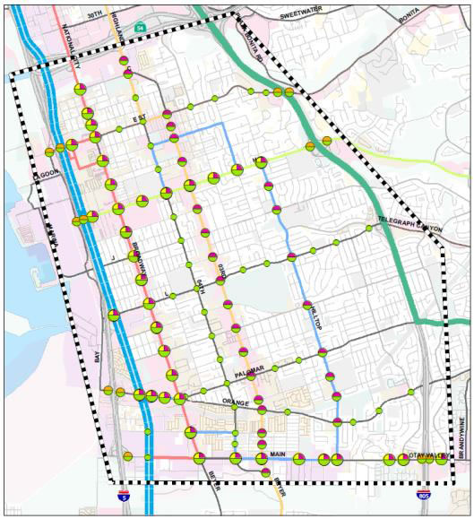
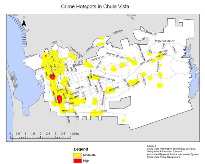
The efforts associated with this grant will focus our deployment of new street lights in the high crime areas of the City with the placement of some street lights at other strategic locations to support our traffic data collection efforts as well as vehicle emission and particles measurement endeavors. As shown on the map to the right, most of our high crime areas are on the western portion of the City. Additional/improved lighting systems will bring an enhancement to our residents' quality of life and allow us to deploy technology such as the "shot spotter" at certain locations to help our police department track down and reduce crime in those areas.
These intelligent street lights are essentially communication hubs so, in addition to the work described above, they will also open up many other possibilities such as the expansion of our municipal Wi-Fi network and the deployment of sensors and communications systems to support autonomous vehicle testing and demonstrations in the near future.
6.3.6 Pedestrian Traffic Light Information System
With vehicle-to-infrastructure technology available today through advance transportation controllers, the City seeks to deploy a Traffic Light Information System to address pedestrian safety at signalized intersections or mid-block crosswalks. According to SWITRS data from 2007 to 2016, pedestrian collisions are on the rise in Chula Vista. The traffic light information system will help to provide on-board notification to approaching vehicles when a pedestrian light is on at an intersection or crosswalk. This would aid to alert drivers to watch for pedestrian when approaching an intersection or midblock crosswalk. The information would be transmitted to the vehicle similar to the application mentioned previously (i.e. green time remaining). In contrast, the information transmitted would be regarding the on and off state of the pedestrian indication.
6.4 Connected Wi-Fi Signals

As a city focused on providing the best quality services to our residents and maximizing our resources, Chula Vista will install a fast, 1-Gig, municipal Wi-Fi solution throughout the city. The municipal Wi-Fi will be created using traffic signal cabinets as "hot spots" with repeater sites near/at bus stops to provide connectivity to its residents. Our new intelligent street lights wills serve as excellent repeater sites and/or hot spots for our Wi-Fi deployment. Given the density of our population (especially low income) and traffic signals on the west side of the City, the Wi-Fi implementation will be particularly strong in this area and serve a number of purposes including providing connectivity (or improved connectivity) to the more disadvantaged communities in the City and the following:
- Disaster relief/emergency evacuations
- Educational opportunities
- Students (of all ages) can study online and/or receive assistance with homework online
- Employment search/research
- Improved access to health services/accounts
- Individuals & families can view/schedule appointments
- Individuals/families can access online workshops and other information to encourage a healthier lifestyle
- Improved access to City services
- Connect to City's ACT Chula Vista App to report maintenance/operational issues
- Access a variety of services on the City's website: http://www.chulavistaca.gov/
In addition, this Wi-Fi network will be dual-purpose. It will also provide connectivity, on a separate-secure network, to City staff operating in the field throughout the City. This will allow for greater levels of efficiency as staff, at various levels/disciplines, is able to quickly access information/data to update or issue new requests on the various City asset/data management systems.
The new Wi-Fi system will also provide connectivity to advanced transportation technology, such as autonomous and automated vehicles, which may operate on a W-Fi system. Finally, where others have struggled/failed in their "free" Wi-Fi installations, Chula Vista will succeed in the implementation of the municipal Wi-Fi because of the following:
- Partner with local vendors/providers for the implementation of the network
- Leverage existing wireless and fiber communications infrastructure
- Add-on to the communications equipment that is part of the traffic signal communications infrastructure
- Establish strategic "hot spots" and repeater sites to serve the public, primarily on the west side of the city, rather than a citywide network with complete coverage
- Design the network with scalability in mind for future expansion as the City continues its path to a Smart City
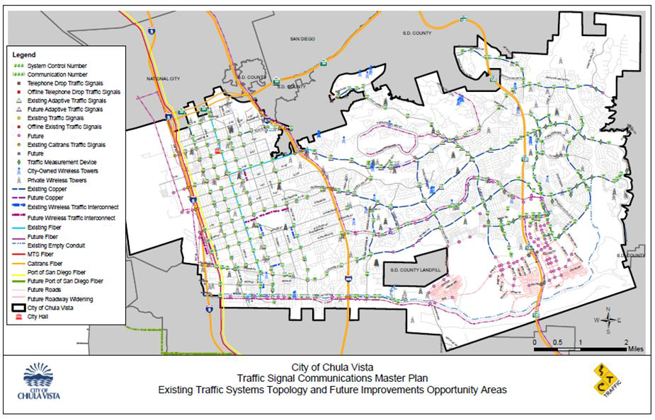
6.5 Communications Systems Upgrades
Chula Vista completed its Traffic Signal Communications Master Plan in June 2017. This Master Plan was an ambitious and necessary endeavor for the City. Although over 90 percent of the City's 267 traffic signals are connected to a central master traffic signal system. These connections are over old telephone lines with 56k modems. This type of communications is extremely costly, limiting, and obsolete. Using the Master Plan as a guide, the City has started the process to abandon the costly telephone line communications and switch to cellular communications (as an intermediate step). In addition, the City has adopted new specifications and standards of communications and transportation system technologies for all new projects moving forward.
Through the ATCMTD grant, the City will deploy a high-capacity wireless radio communications system on the west side of the city which will carry/support:
- Traffic signal data
- HD ITS cameras
- Data collection systems
- Intelligent street light technologies
- Municipal Wi-Fi
- Other Smart City applications
The proposed wireless network would tie into existing City fiber optics (along 4th Avenue and H Street) and, also, to privately-owned fiber optics systems in the City. Note that the City has initiated conversations with local vendors to discuss opportunities to partner up in order to provide system redundancy and lower our deployment costs.
On the east side, we will also establish a high capacity network. However, given the existing conditions, we are able to repurpose some of our existing infrastructure to:
- Repurpose existing copper to implement Ethernet-over-copper applications
- Install fiber optic cable in existing conduits
- Install high-capacity radios to tie into the City's existing pump station radio network which is currently being upgraded
The extensive privately-owned (empty) conduit network throughout the City will provide an opportunity for us to meet our goal of establishing a fully-connected, redundant, reliable, and robust transportation system network with opportunities to support other departments/agencies citywide. This new network will be the foundation for our Smart City deployments which will best make use of cutting-edge technology to maximize the use of our City resources and provide a better quality of life to our residents through transportation.
6.6 Asset Management Systems
6.6.1 Traffic Signal Communications & Wi-Fi Devices
IP based traffic signal communication equipment and Wi-Fi devices will be managed through an IT inventory management system. The proposed system will provide a centralized system that includes software audit & inventory, asset management, active directory management, and Simple Network Management Protocol (SNMP).
Fiber optic infrastructure will be managed utilizing an Optical Time Domain Reflector system that provide reporting and alerting of fiber optic link status and testing.
6.6.2 Signal Pole and ITS Cabinet Equipment
Traffic signal pole and cabinet equipment will be managed through a mobile asset management system with an integrated barcoding registry system and maintenance log tracker. The system will allow maintenance operators to quickly inventory assets, provide remote monitoring, and report and query assets. In addition, cabinet health devices similar to DA-300 will be installed to monitor critical traffic equipment and intersection faults.
6 AECOM, Effectives Study East Main Street, September 2015 [Return to Note 6]
7 SANDAG, November 2016, http://sandag.org/uploads/publicationid/publicationid_2014_20482.pdf [Return to Note 7]
8 Clark County Fire Department, GPS Fire Response, http://www.clarkcountynv.gov/fire/Pages/default.aspx [Return to Note 8]