INTRODUCTION
Highway work zones present challenges to work zone safety and mobility. Work zones often reduce roadway capacity, causing congestion and traveler delay and creating irregular traffic flow. These factors, as well as the changing lane configurations and other factors in work zones, can lead to safety hazards. There are more than 500 fatalities and 37,000 injuries in work zones every year.1 However, work zones are a necessary part of maintaining and rehabilitating our transportation infrastructure. These needs are increasing as our transportation system ages, which means more work zones will likely occur. These factors all combine to create challenges to moving traffic smoothly and safely through work zones and which heightens the need for finding new ways to enhance work zone traffic management. Agencies are deploying intelligent transportation systems (ITS) to help manage traffic in and around work zones more efficiently.
What is work zone ITS?
ITS is the use of a broad range of communications-based information and electronics technologies to enhance transportation. These systems generally include:
- Sensors and other components in the field to collect traffic information, such as traffic volumes and speeds and video of traffic flow
- Communications links (wireless and wired) to transmit that data for processing or dissemination
- Software that processes and analyzes the data, converting it to information that can be used by other components and various users of the information
- Electronic equipment to disseminate the processed information to end users of the information, such as motorists and transportation agencies.
Work zone ITS is the use of ITS to enhance transportation and improve safety and mobility in and around work zones. Information provided by work zone ITS may be in the form of real-time traffic conditions, such as travel delays through a work zone or recommended diversion routes, which can be used my motorists to alter their travel behavior and by contractors and transportation agencies to alter traffic control strategies, traveler information, or work schedules. Work zone ITS may also be used to provide immediate warnings, such as to drivers that traffic is stopped ahead or that a slow truck is entering from a work zone or to workers that a vehicle is intruding into their work area.
A work zone ITS deployment can be focused around safety or mobility, but often supports both goals, and can also enhance productivity. The systems are portable and temporary in most cases, although some deployments may use either existing fixed infrastructure or become a permanent system.
A work zone ITS deployment varies in scale based on the magnitude of the construction project and the specific concerns being addressed in a given location. Not all ITS deployments are complicated and expensive. One of the most common components of a work zone ITS deployment is a portable changeable message signs (PCMS) that can be used to communicate traffic conditions to motorists, as shown in Figure 1, based on real-time traffic data collected from sensors.
ITS deployments can have the same objective, but vary widely in how the objective is achieved. Factors that vary from deployment to deployment include:
- What type of data is collected (e.g., traffic volumes and speeds, queue detection);
- How data is collected (e.g., radar, cameras);
- How data is communicated (e.g., cellular, Bluetooth, fiber optic connection);
- What level of detail of information is disseminated (e.g., “slow traffic ahead”, “speed ahead 35 mph”);
- How that information is shared (e.g., websites, PCMS);
- How “real-time” the information is (e.g., predicted, based on current speeds).
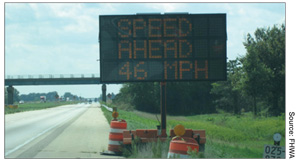
downstream traffic speeds from sensor data.
Work zone ITS may be leased or purchased through variety of procurement mechanisms. In some cases, data may be leased/purchased from a third party that is already collecting the data (e.g., through Bluetooth) and the ITS is primarily used to process and disseminate the information.
Users of the information provided by work zone ITS may include departments of transportation (DOTs), the public and road users, nearby businesses and employers, media outlets, contractors, trucking companies, emergency services providers, motorist assistance patrols, and third party traveler information providers.
Some current technology options and strategies
ITS can be used to help address many work zone challenges and can take many forms in work zone applications. For example:
Challenge: Frequent but unpredictable congestion due to long-term or short-term lane closures.
Potential application: Benefits may be achieved from deploying a system that detects the onset of congestion, measures conditions on nearby alternate route(s), and automatically presents current travel times on the alternate and the current roadway to encourage diversion when appropriate. If alternate routes are not available, the work zone may benefit from an automatic queue detection warning system if the speed differential between approaching traffic and the traffic already in the queue is large.
Challenge: Reduced or eliminated emergency shoulders.
Potential application: Benefits may be achieved from an ITS deployment that focuses on incident detection, verification, and response within the work zone.
Challenge: Need for frequent direct access by construction vehicles and equipment to/from the travel lanes may result in conflicts with other road users, such as drivers following work vehicles into the work space or large speed differentials between motorists and construction vehicles entering the travel lanes from the work space.
Potential application: ITS could be used to notify motorists following a work vehicle that it will be entering the work zone and not to follow the construction vehicle, or to determine when the entrance of a construction vehicle is imminent and warn approaching motorists or direct them to change lanes or to stop.
Challenge: Agencies may impose penalties to contractors for creating excessive delays or queues during a project, but may not have the personnel available to monitor work activities continuously to verify compliance.
Potential application: Work zone ITS can be deployed to monitor and archive traffic conditions continuously, and the resulting data can be used when assessing liquidated damages or lane rental fees. Archived data can also be used to evaluate traffic control plan changes or even analyze and estimate impacts in future similar work zones.
Table 1 provides a listing of common work zone ITS applications. It summarizes the components included in each application and provides a general indication of the safety and mobility issues the application attempts to address. As Table 1 suggests, many of the same ITS components are used in each application. Consequently, there are some overlaps in how systems can be designed and implemented to address specific work zone conditions. The differences between applications lie primarily in how the systems are designed to convey information to the motorist or traveler.
The applications presented in Table 1 may be deployed individually or be grouped together depending on the work zone. Ultimately, all of these applications seek to provide a more active management capability to the agency to achieve desired mobility and/or safety goals. Additional deployment examples have been documented in numerous case studies conducted by FHWA on work zone ITS.2 As a part of this project, FHWA sponsored additional case studies to examine deployments of ITS in work zones in Effingham, Illinois; Mount Vernon, Illinois; Salt Lake City, Utah; Orem/Provo, Utah; and Las Vegas, Nevada in 2012.
| Work Zone ITS | Brief System Description | ITS Components | Issue(s) being Addressed | Example of Deployment |
|---|---|---|---|---|
| Real-time Traveler Information | Drivers provided information about current travel conditions; can be used to encourage diversion |
|
|
For the I-15 Corridor Expansion (CORE) project, Utah DOT
monitored travel times for I-15 and US-89 and posted current, comparative
information on dynamic message signs to reduce delays, stops, emissions, and
the number and severity of traffic incidents. http://www.i15core.utah.gov/ |
| Queue Warning | Signs provide warnings to drivers about stopped or slow traffic ahead |
|
|
For a large work zone on I-35, Texas DOT used sensors to
detect the formation of queues and warn drivers of slowed or stopped traffic
downstream via CMS. https://ops.fhwa.dot.gov/wz/resources/news/wznews_detail.asp?id=618 |
| Dynamic Lane Merge (early merge, late merge) | Signs encourage drivers to merge at a specified point based on current conditions |
|
|
Dynamic lane merge systems on I-95 and evaluated by Florida
DOT have shown potential to enhance safety and operations. http://www.dot.state.fl.us/research-center/Completed_Proj/Summary_CN/FDOT_BD548-24_rpt.pdf |
| Incident Management | Enables faster detection of incidents for quicker response and clearance time |
|
|
The Big I project in New Mexico incorporated an incident
management system to provide accurate information, support quick
identification of incidents, and help to manage area traffic. https://ops.fhwa.dot.gov/wz/technologies/albuquerque/index.htm |
| Variable Speed Limits (VSL) | Can provide speed harmonization and calm traffic for slow or stopped traffic ahead |
|
|
In 2008, VSL signs were used by Utah DOT in a work zone on
I-80 and by Virginia DOT on the I-495/I-95 Capital Beltway. (http://www.udot.utah.gov/main/uconowner.gf?n=7828313631638132, http://www.virginiadot.org/vtrc/main/online_reports/pdf/10-r20.pdf) |
| Automated Enforcement | Automated system detects and captures images of speeding vehicles for enforcement purposes |
|
|
Some states utilize speed-radar photo enforcement in work zones,
including Illinois, which uses vans with retrofitted equipment to reduce
speeds through work zones and work zone fatalities. http://onlinepubs.trb.org/onlinepubs/trnews/trnews277rpo.pdf. |
| Entering/exiting vehicle notification | Signs can warn drivers of a slow-moving construction or emergency vehicle entering or exiting the roadway |
|
|
Pennsylvania DOT used an innovative system for a unique
problem involving emergency vehicle access. The system utilized
siren-activated pre-emption technology on emergency vehicles to activate CMS
alerting oncoming vehicles that a slow-moving emergency vehicle would be
entering the roadway. http://www.roadsbridges.com/case-fire |
| Performance Measurement | Monitor and archive traffic conditions data to support real-time traveler information, modify operations, and support evaluation. |
|
|
Both Ohio and Indiana DOTs have established policies on acceptable work zone queue length and duration. Work zone ITS can monitor and archive traffic data that can be used to evaluate performance measures, including those used in performance-based contracting. |
Benefits that are possible with work zone ITS
ITS work zone systems have the capability to provide significant benefits to agencies and to those affected by the mobility and safety impacts of road construction and maintenance work zones. Many agencies have already begun to experience benefits and to pass those experiences on to others. In general terms, potential benefit impact areas associated with the use of ITS in work zones are as follows:
- Safety – ITS can help to minimize the consequences of work zones on both traveler and worker safety. Credible warnings of the presence of unexpected queues, notification and reassurance of travel times to reduce driver stress, and credible warnings of construction vehicle access and egress are examples of how work zone ITS can improve the safety of both travelers and workers. Systems that automatically adjust the speed limit of the work zone to current conditions, automate enforcement of traffic laws, or help to quickly identify when incidents have occurred in work zones can also significantly improve safety. For example, the use of an incident management system in a New Mexico work zone reduced average incident clearance time by 20 minutes and is believed to have reduced the frequency of secondary crashes.3
- Mobility – Reduced travel time delay is a primary benefit of many work zone ITS applications. Travelers making adjustments to their route, departure time, or mode choices based on information provided by ITS, or the use of alternate traffic management practices (e.g., dynamic lane merging, VSL) via ITS can reduce delay. For example, real-time traveler information induced up to 19% diversion away from a route with a work zone in California.3 These adjustments benefit not only those travelers who made changes to their trips, but others who continued to travel through the work zone. Mobility benefits will be especially high on facilities that serve a large amount of commercial vehicle traffic, as the value of commercial vehicle travel time is very high.
- Improved work productivity and durability – Work zone ITS can also improve agency and contractor productivity and efficiency, ultimately reducing the number of days that the work zone is present and reducing contractor operating costs. Reduced congestion and improved mobility can allow the contractor to use fewer trucks to bring materials into the work space during certain work operations. Better control over material delivery time can result in more durable, high-quality construction. Real-time monitoring of traffic volumes can allow agencies and contractors to initiate lane closure activities as soon as conditions will allow each day or night, rather than wait for a prescribed time that is typically based on a worst-case estimate of traffic demands. Further, the use of ITS in and around work zones can allow for the automation of functions that would normally have to be performed manually by agency personnel. For example, work zone ITS can be deployed to monitor and archive traffic conditions continuously, and the resulting data can assist agencies in imposing penalties on contractors for creating excessive delays or queues during a project. Archived data from work zone ITS can also be used to evaluate traffic control plan changes or analyze and estimate impacts in future similar work zones.
- Customer satisfaction – Information gathered and provided by work zone ITS can lead to increased customer satisfaction. ITS allows agencies to update motorists about changes in traffic conditions in the same fashion they occur—in real time. The relative ease of relaying information to the media, websites, social media, and phone applications can enable more frequent updates, as well as wider access to this information. To improve customer satisfaction by reducing delay, a project in Utah used an advanced traffic management system to monitor traffic and post comparative travel time information on CMS, as shown in Figure 3.3 On the CMS, an arrow to the left indicated the travel time to Lehi using I-15 (accessible to the left) and an arrow pointing ahead indicated the travel time via an alternate route (State Street). In Little Rock, Arkansas, 82 percent of drivers surveyed agreed that an Automated Work Zone Information System improved their ability to react to slow or stopped traffic.4 Awareness of real-time work zone conditions can improve the favorable perception of the agency to travelers, business owners, residents, and users within the agency.
Purpose and organization of this document
The purpose of this document is to provide guidance on implementing ITS in work zones to assist public agencies, design and construction firms, and industry, including developers, manufacturers, distributors, packagers, and providers of devices, systems, and programs. Work zone ITS is one possible operational strategy of many potential solutions that an agency can include in a transportation management plan (TMP). A TMP, as required by the work zone Safety and Mobility Rule5, lays out a set of work zone management strategies—work zone traffic control, public information and outreach, transportation operations—that the agency will use to manage the impacts of a particular road project. Considering whether to deploy work zone ITS on a project and designing and deploying a system should be done as part of work zone impacts assessment and TMP development and implementation.
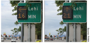
for two different routes to the town of Lehi that was used for a project in Utah.
This document summarizes key steps for implementing ITS in work zones. Successful implementation of ITS applications in work zones requires a systematic approach to provide a technical solution that accomplishes a specific set of clearly defined objectives. The document illustrates how a systems engineering process should be applied to determine the feasibility and design of work zone ITS for a given application by walking through the key phases, from project concept through operation. In addition, the guide discusses evaluating the effectiveness of the system in achieving stakeholder goals (an important but often overlooked activity).
The guide identifies where and how existing regional and statewide ITS architectures should be considered for consistency and interoperability with currently deployed ITS elements, especially when the systems will become part of a permanent deployment.6
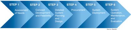
This document is organized into chapters corresponding to the steps in the development and implementation process, which are shown in Figure 4. Each chapter addresses the challenges and barriers that agencies may face in deploying ITS applications. Lessons learned are included where appropriate (and compiled in Appendix C), to provide information on how other agencies have overcome these challenges and potential barriers.
This document is intended to guide users through the deployment of any work zone ITS, regardless of its scale. Although the overall scope of the envisioned project will ultimately determine the complexity and level of effort required during planning, the steps included in this document should apply equally to the range of deployments, from small-scale, temporary deployments lasting a few months to complex, multi-year ITS deployments that may eventually be incorporated into permanent traffic monitoring and management systems.
1As of 2010; for more information, see: https://ops.fhwa.dot.gov/wz/resources/facts_stats/injuries_fatalities.htm.
2Additional information on these case studies can be found at: https://ops.fhwa.dot.gov/wz/its.
3For more information and other examples, see: https://ops.fhwa.dot.gov/wz/its
4Additional information can be found at: http://www.itsbenefits.its.dot.gov/ITS/benecost.nsf/ID/76C9F2DE2BF5DB1D85257603004E031D?OpenDocument&Query=Home.
5More information on the Rule (23 CFR 630 Subpart J) is available at: https://ops.fhwa.dot.gov/wz/resources/final_rule.htm.
6More information on ITS architecture is available at: https://ops.fhwa.dot.gov/its_arch_imp.
You may need the Adobe® Reader® to view the PDFs on this page.
< Previous | Next >