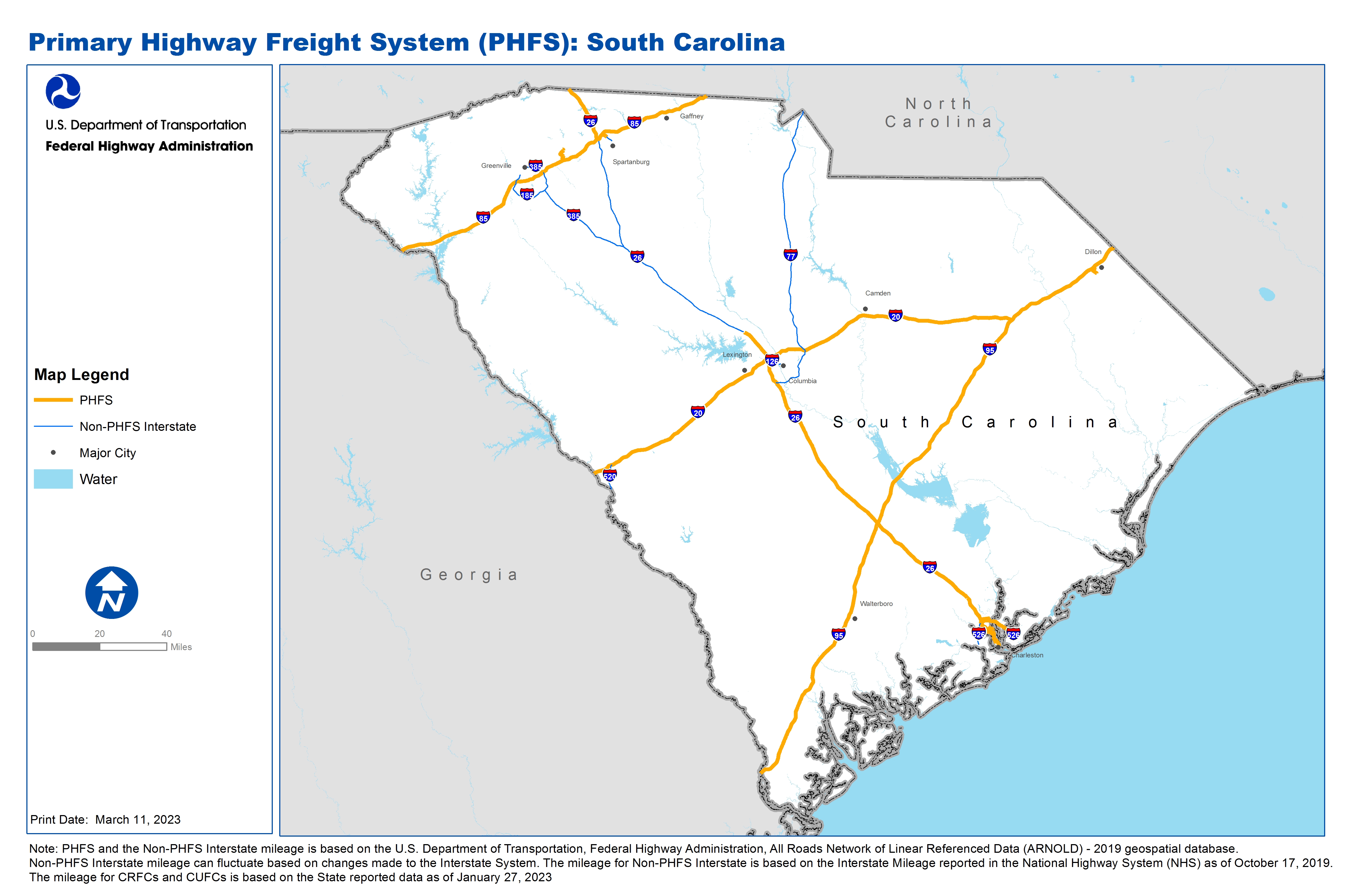
National Highway Freight Network Map and Tables for South Carolina, 2022
High-Resolution Images
- JPG 2.8MB
Table of National Highway Freight Network Routes, 2022
State |
Route No/ Facility Name |
Start Point |
End Point |
Route/Facility Description |
Length (Miles) |
|---|---|---|---|---|---|
SC |
I20 |
GA/SC Line |
I95 |
I20 from GA/SC Line to I95 |
141.38 |
SC |
I26 |
U176 |
U17 |
I26 from U176 to U17 |
124.10 |
SC |
I26 |
I85 |
SC/NC Line |
I26 from I85 to SC/NC Line |
17.80 |
SC |
I385 |
3.34 Miles West of I85 |
0.32 Miles East of I85 |
I385 from 3.34 Miles West of I85 to 0.32 Miles East of I85 |
3.72 |
SC |
I526 |
SC9P |
I26 |
I526 from SC9P to I26 |
10.48 |
SC |
I85 |
GA/SC Line |
SC/NC Line |
I85 from GA/SC Line to SC/NC Line |
106.75 |
SC |
I95 |
GA/SC Line |
SC/NC Line |
I95 from GA/SC Line to SC/NC Line |
198.73 |
SC |
U176 |
I85 |
I585 |
U176 from I85 to I585 |
1.68 |
SC |
SC10P - Columbus St/Union Pier Terminal |
I26 |
Columbus St/Union Pier Terminal |
Morrison Dr from I-26 South to Charlotte Street, east to Washington St, south to the terminal |
2.80 |
SC |
SC5R - Charleston Rail Facility (CSX) |
I26 |
Charleston Rail Facility (CSX) |
S-62 (Montague Ave) S-1411 (Blossom St) between I-26 and the Rail Freight Yard |
0.73 |
SC |
SC8P - North Charleston Terminal |
I26 |
North Charleston Terminal |
Remount Rd (Terminal) Remount Rd (Terminal to I-26) |
2.92 |
SC |
SC9P - Wando Terminal |
I526 |
Wando Terminal |
State Rd S--10-97 from I-526 to the terminal |
0.74 |
SC |
Veterans Terminal |
SC-7 from I-26 |
Veterans Terminal |
SC-7 from I-26 Cosgrove Ave, Spruill Ave, McMillan Ave, N Hobson Ave until Viaduct Rd) |
2.86 |
SC |
Inland Port Greer |
SC 12 from I-85 |
Inland Port Greer |
SC 12 from I-85 SC 101 to J Verne Smith Pkwy to GSP Logistic Pkwy to Int Commerce Blvd to facility |
4.71 |
SC |
Inland Port Dillon |
SC-34 from I-95 |
Inland Port Dillon |
SC-34 from I-95 Industrial Pk Rd to Fairfield Rd to facility |
2.99 |
SC |
Hugh Leatherman Terminal |
Port access Rd from I-26 |
Hugh Leatherman Terminal |
Port access Rd from I-26 0.797 mile on port access Rd |
1.08 |
PHFS Total |
|
|
|
|
623.47 |
State |
Route No/ Facility Name |
Start Point |
End Point |
Route/Facility Description |
Length (Miles) |
|---|---|---|---|---|---|
SC |
I126 |
I26 |
S133 |
I126 from I26 to S133 |
3.62 |
SC |
I185 |
U29 |
I385 |
I185 from U29 to I385 |
16.34 |
SC |
I26 |
I85 |
0.31 Miles West of U176 |
I26 from I85 to 0.31 Miles West of U176 |
78.35 |
SC |
I385 |
U276 |
0.21 Miles East of S291 |
I385 from U276 to 0.21 Miles East of S291 |
2.19 |
SC |
I385 |
0.32 Miles East of I85 |
I26 |
I385 from 0.32 Miles East of I85 to I26 |
35.67 |
SC |
I526 |
I26 |
U17 (West) |
I526 from I26 to U17 (West) |
7.03 |
SC |
I526 |
Long Point Rd |
U17 (East) |
I526 from Long Point Rd to U17 (East) |
2.09 |
SC |
I585 |
U176 (West) |
U176 (East) |
I585 from U176 (West) to U176 (East) |
2.08 |
SC |
I77 |
I26 |
SC/NC Line |
I77 from I26 to SC/NC Line |
91.08 |
SC |
I520 |
GA/SC Line |
I20 |
I520 from GA/SC Line to I20 |
7.94 |
INTERSTATE NON-PHFS Total |
246.39 |
Note: PHFS and the Non-PHFS Interstate mileage is based on the U.S. Department of Transportation, Federal Highway Administration, All Roads Network of Linear Referenced Data (ARNOLD) - 2019 geospatial database. Non-PHFS Interstate mileage can fluctuate based on changes made to the Interstate System. The mileage for Non-PHFS Interstate is based on the Interstate Mileage reported in the National Highway System (NHS) as of October 17, 2019. The mileage for CRFCs and CUFCs is based on the State reported data as of January 27, 2023