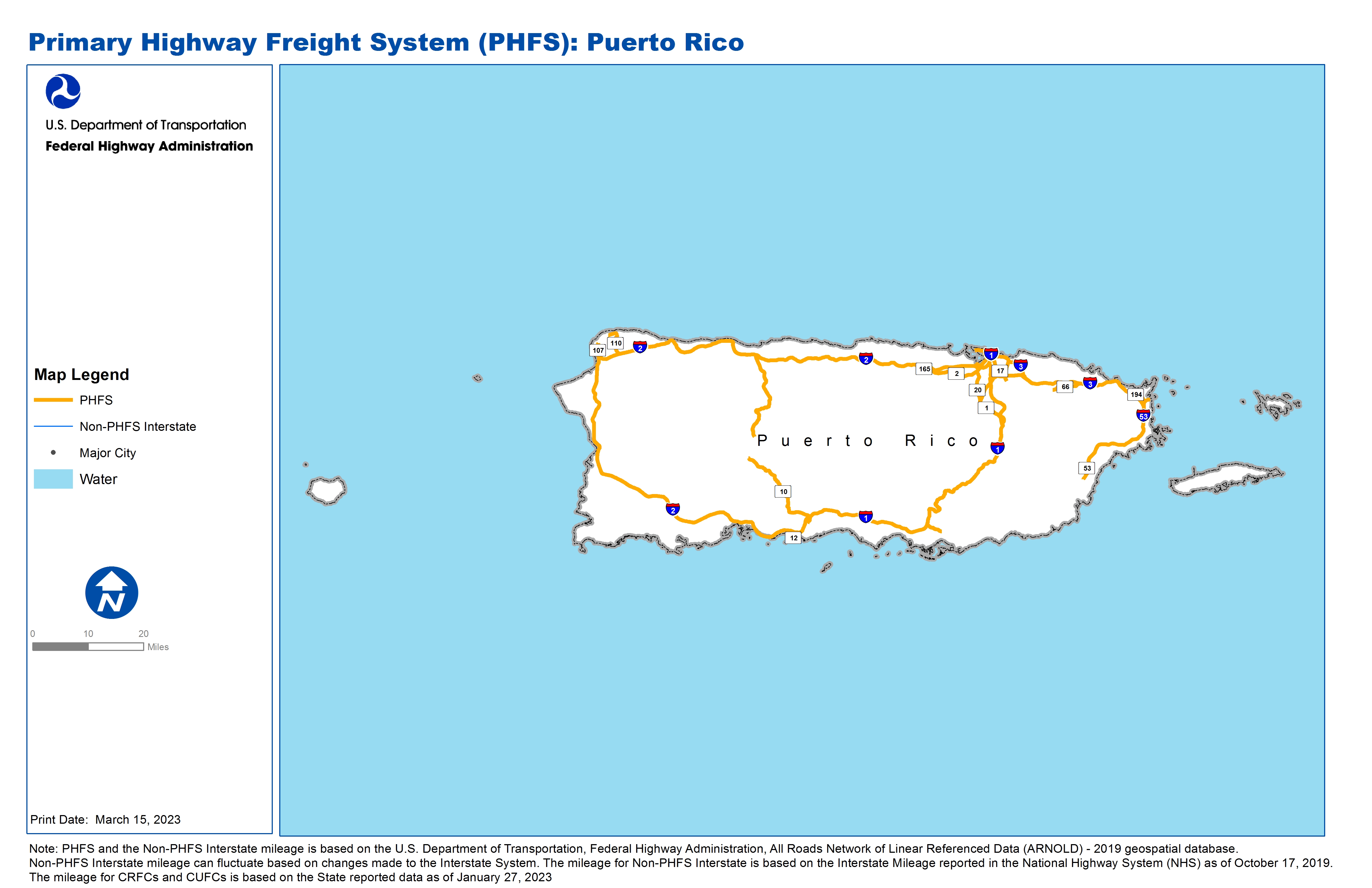
National Highway Freight Network Map and Tables for Puerto Rico, 2022
High-Resolution Images
- JPG 1.8MB
Table of National Highway Freight Network Routes, 2022
State |
Route No/ Facility Name |
Start Point |
End Point |
Route/Facility Description |
Length (Miles) |
|---|---|---|---|---|---|
PR |
Expreso Rafael M Nadal |
S1 |
S20 |
Expreso Rafael M Nadal from S1 to S20 |
0.41 |
PR |
IPRI-1 |
IPRI-2 |
S26 |
IPRI-1 from IPRI-2 to S26 |
72.90 |
PR |
IPRI-2 |
IPRI-1 |
IPRI-1 |
IPRI-2 from IPRI-1 to IPRI-1 |
138.39 |
PR |
IPRI-3 |
S53 |
IPRI-1 |
IPRI-3 from S53 to IPRI-1 |
32.87 |
PR |
S1 |
IPRI-1 |
Expreso Rafael M Nadal |
S1 from IPRI-1 to Expreso Rafael M Nadal |
6.26 |
PR |
S1 |
PR7P |
Expreso Rafael M Nadal |
S1 from PR7P to Expreso Rafael M Nadal |
11.23 |
PR |
S10 |
IPRI-1 |
S123 |
S10 from IPRI-1 to S123 |
17.73 |
PR |
S10 |
S123 |
IPRI-2 |
S10 from S123 to IPRI-2 |
18.47 |
PR |
S165 |
S2 |
IPRI-2 |
S165 from S2 to IPRI-2 |
0.51 |
PR |
S17 |
IPRI-1 |
S181 |
S17 from IPRI-1 to S181 |
4.55 |
PR |
S181 |
Avenida Frontera |
S17 |
S181 from Avenida Frontera to S17 |
2.00 |
PR |
S2 |
S165 |
S1 |
S2 from S165 to S1 |
13.21 |
PR |
S20 |
Expreso Rafael M Nadal |
S2 |
S20 from Expreso Rafael M Nadal to S2 |
5.63 |
PR |
S21 |
IPRI-1 |
S1 |
S21 from IPRI-1 to S1 |
0.63 |
PR |
S26 |
PR7P |
IPRI-1 |
S26 from PR7P to IPRI-1 |
1.39 |
PR |
S28 |
S2 |
S165 |
S28 from S2 to S165 |
1.11 |
PR |
S3 |
S1 |
IPRI-3 |
S3 from S1 to IPRI-3 |
5.39 |
PR |
S53 |
IPRI-1 |
Guayama County Line |
S53 from IPRI-1 to Guayama County Line |
3.01 |
PR |
S53 |
S30 |
IPRI-3 |
S53 from S30 to IPRI-3 |
20.92 |
PR |
S66 |
S185 |
IPRI-3 |
S66 from S185 to IPRI-3 |
5.43 |
PR |
PR1A - Rafael Hernandez Airport, Aguadilla |
S2 |
Rafael Hernandez Airport, Aguadilla |
From PR-2 (km 124.5): North 2.8 miles on PR-107 to Old Ramey Air Force Base. From PR-2 (km 118.9): North 6.21 miles on PR-110 to Old Ramey Air Force Base |
8.83 |
PR |
PR2A - Mercedita Airport, Ponce |
S52 |
Mercedita Airport, Ponce |
From PR-52 (km 96.8): South 1.9 miles on PR-10 to airport |
1.19 |
PR |
PR3P - Ponce Port, Ponce |
S52 |
Ponce Port, Ponce |
From PR-52 (km 104.9): South 1.1 miles on PR-12 to port |
1.27 |
PR |
PR4P - Fajardo Port, Fajardo |
S3 |
Fajardo Port, Fajardo |
From PR-3 (km 43.4): southeasterly 2.1 mi on PR- 194 and easterly 1.2 mi on PR-195 to port. From PR-3 (km 47.6): north 0.6 mi on PR-194, 0.43 mi on Marcelito Gotay St to PR-195 |
4.57 |
PR |
PR7P - San Juan Port, San Juan (North) |
S1 |
San Juan Port, San Juan (North) |
From PR-1/25: west 1.95 miles on PR-1 to port |
2.10 |
PHFS Total |
380.01 |
||||
State |
Route No/ Facility Name |
Start Point |
End Point |
Route/Facility Description |
Length (Miles) |
|---|---|---|---|---|---|
INTERSTATE NON-PHFS Total |
0 |
||||
Note: PHFS and the Non-PHFS Interstate mileage is based on the U.S. Department of Transportation, Federal Highway Administration, All Roads Network of Linear Referenced Data (ARNOLD) - 2019 geospatial database. Non-PHFS Interstate mileage can fluctuate based on changes made to the Interstate System. The mileage for Non-PHFS Interstate is based on the Interstate Mileage reported in the National Highway System (NHS) as of October 17, 2019. The mileage for CRFCs and CUFCs is based on the State reported data as of January 27, 2023