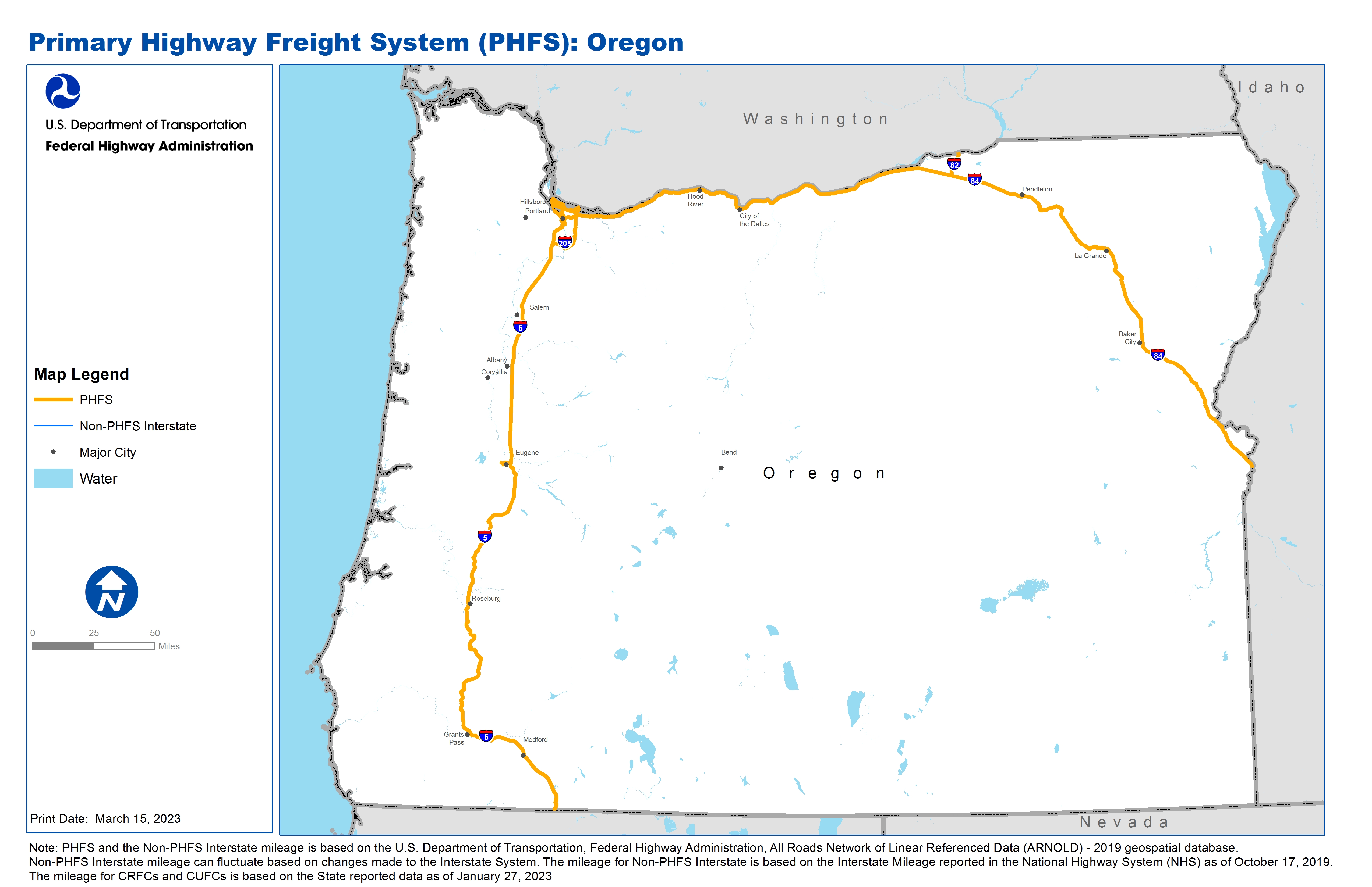
National Highway Freight Network Map and Tables for Oregon, 2022

High-Resolution Images
- JPG 2.3MB
Table of Final Primary Freight Network Routes, 2022
State |
Route No/ Facility Name |
Start Point |
End Point |
Route/Facility Description |
Length (Miles) |
|---|---|---|---|---|---|
OR |
Belmont St |
S99E |
I5 |
Belmont St from S99E to I5 |
0.26 |
OR |
I105 |
S99 |
I5 |
I105 from S99 to I5 |
3.49 |
OR |
I205 |
I5 |
OR/WA Line |
I205 from I5 to OR/WA Line |
26.06 |
OR |
I405 |
I5 |
I5 |
I405 from I5 to I5 |
3.90 |
OR |
I5 |
CA/OR Line |
OR/WA Line |
I5 from CA/OR Line to OR/WA Line |
308.24 |
OR |
I82 |
I84 |
OR/WA Line |
I82 from I84 to OR/WA Line |
10.71 |
OR |
I84 |
I5 |
OR/ID Line |
I84 from I5 to OR/ID Line |
375.67 |
OR |
S99E |
OR6R |
Belmont St |
S99E from OR6R to Belmont St |
1.89 |
OR |
S99 |
OR17R |
I105 |
S99 from OR17R to I105 |
1.11 |
OR |
U30 |
OR24P |
I405 |
U30 from OR24P to I405 |
1.25 |
OR |
OR10L - NW Industrial Area |
OR9R |
NW Industrial Area |
Front Ave between Kittridge Ave and 61st St, 61st St between Culebra Ave and Front Ave, Culebra Ave between Balboa Ave and 61st St |
1.30 |
OR |
OR11R - Lake Yards |
OR10L |
Lake Yards |
Front Ave between Kittridge and Nicolai, Nicolai St between Yeon Ave and Front St. |
2.23 |
OR |
OR12R - Albina Yards (UP), Portland |
I405 |
Albina Yards (UP), Portland |
Interstate Ave between Going St and Larrabee Ave, Russell St between Interstate Ave and Rail Facility, Going St between Basin and I-5 (Hwy 1), Larrabee Ave between Broadway St and Interstate Ave |
2.07 |
OR |
OR13P - Port of Portland (Terminal 5) |
Lombard St |
Port of Portland (Terminal 5) |
Terminal 5 Access Rd between Lombard St and Terminal 5. US 30BY (Hwy 123) between US 30 (Hwy 92) and Ivanhoe St, Ivanhoe St between US 30BY (Hwy 123) and N Saint Louis, N Saint Louis between Lombard Blvd and Ivanhoe St, Burgard St and Lombard St between |
17.48 |
OR |
OR14P - Port of Portland (Terminal 6) |
Lombard St |
Port of Portland (Terminal 6) |
N Pacific Gateway Blvd between N Marine Dr and Terminal 6. See Port of Portland Terminal 5 connector description. . |
0.19 |
OR |
OR15P - Port of Portland (Terminal 4) |
Lombard St |
Port of Portland (Terminal 4) |
N Terminal Rd between Lombard St and Terminal 4. See Port of Portland Terminal 5 connector description. . |
0.07 |
OR |
OR17R - Eugene Reload Facilities, Eugene |
S91 |
Eugene Reload Facilities, Eugene |
Garfield St between 7th Ave and Cross St, Cross St between Garfield St and Cleveland St, Cleveland St between Cross and Roosevelt, Roosevelt Blvd between Cleveland St and OR99 (Hwy 91) |
1.49 |
OR |
OR23P - Swan Island Ship Repair Yard |
I5 |
Swan Island Ship Repair Yard |
Going St between Basin St and I-5 (Hwy 1) (See Alpina Yards (UP) Portland). Greely Ave between I-5 (Hwy 1) CN 001TQ and Going St. . |
2.10 |
OR |
OR24P - Port of Portland (Terminals 1 and 2) |
U30 |
Port of Portland (Terminals 1 and 2) |
Port Access Rd between Yeon St and Front Ave. . |
0.35 |
OR |
OR6R - Brooklyn Yard (SP), Portland |
S99E |
Brooklyn Yard (SP), Portland |
Holgate Blvd between McLoughlin Blvd or 99E (Hwy 81) and UPRR Track |
0.55 |
OR |
OR8A - Portland International Airport |
Columbia Blvd |
Portland International Airport |
Columbia Blvd between Hwy 123 (Killingsworth St) and I-5, US 30BY (Columbia Blvd) between Killingsworth and I-205 CN 123AE. 47th Ave between Columbia Blvd and Cornfoot Rd, Cornfoot Rd between 47th and Alderwood Rd, Alderwood Rd between Cornfoot Rd and 8 |
13.23 |
OR |
OR9R - Willridge Yards |
U30 |
Willridge Yards |
Balboa Ave between Culebra Ave and US 30 (Hwy 92) |
0.08 |
PHFS Total |
773.75 |
||||
State |
Route No/ Facility Name |
Start Point |
End Point |
Route/Facility Description |
Length (Miles) |
|---|---|---|---|---|---|
INTERSTATE NON-PHFS Total |
0 |
||||
Note: PHFS and the Non-PHFS Interstate mileage is based on the U.S. Department of Transportation, Federal Highway Administration, All Roads Network of Linear Referenced Data (ARNOLD) - 2019 geospatial database. Non-PHFS Interstate mileage can fluctuate based on changes made to the Interstate System. The mileage for Non-PHFS Interstate is based on the Interstate Mileage reported in the National Highway System (NHS) as of October 17, 2019. The mileage for CRFCs and CUFCs is based on the State reported data as of January 27, 2023