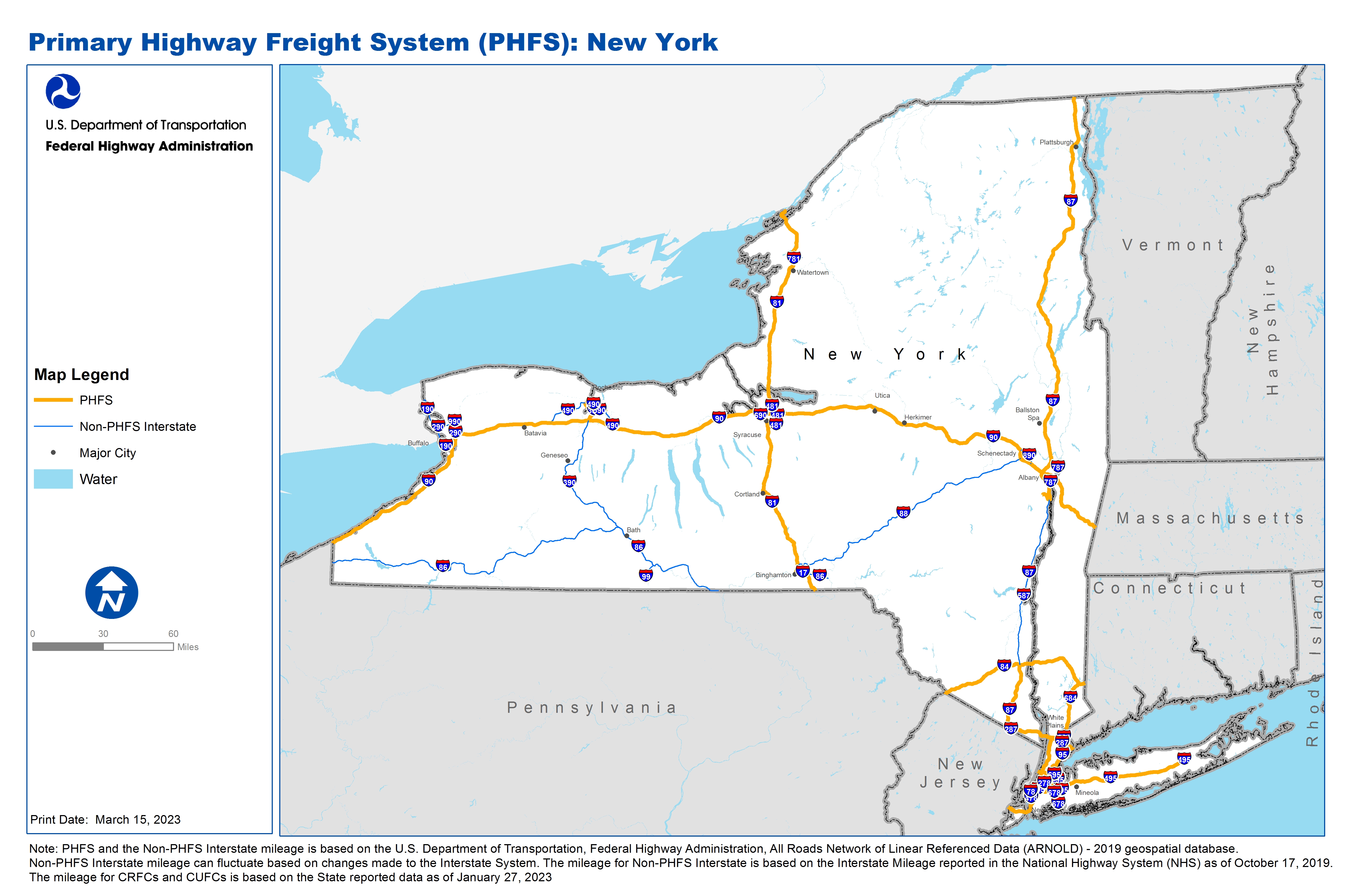
National Highway Freight Network Map and Tables for New York, 2022

High-Resolution Images
- JPG 3.4MB
Table of Final Primary Freight Network Routes, 2022
State |
Route No/ Facility Name |
Start Point |
End Point |
Route/Facility Description |
Length (Miles) |
|---|---|---|---|---|---|
NY |
I190 |
I90 |
Peace Bridge |
I190 from I90 to Peace Bridge |
6.91 |
NY |
I278 |
NJ/NY Line |
I95 |
I278 from NJ/NY Line to I95 |
33.31 |
NY |
I287 |
NJ/NY Line |
I87 |
I287 from NJ/NY Line to I87 |
0.57 |
NY |
I287 |
I95 |
I87 |
I287 from I95 to I87 |
11.74 |
NY |
I290 |
I90 |
I990 |
I290 from I90 to I990 |
4.22 |
NY |
I295 |
I495 |
I95 |
I295 from I495 to I95 |
7.51 |
NY |
I390 |
I90 |
I490 |
I390 from I90 to I490 |
11.03 |
NY |
I481 |
NY80R |
I90 |
I481 from NY80R to I90 |
1.16 |
NY |
I490 |
I390 |
S31F (Fairport Rd) |
I490 from I390 to S31F (Fairport Rd) |
10.45 |
NY |
I495 |
I278 |
C111 (Eastport Manor Rd) |
I495 from I278 to C111 (Eastport Manor Rd) |
62.16 |
NY |
I590 |
I390 |
I490 |
I590 from I390 to I490 |
4.91 |
NY |
I678 |
S878 |
I95 |
I678 from S878 to I95 |
12.28 |
NY |
I684 |
I287 |
NY/CT Line |
I684 from I287 to NY/CT Line |
5.05 |
NY |
I684 |
CT/NY Line |
I84 |
I684 from CT/NY Line to I84 |
21.80 |
NY |
I787 |
NY73P |
I87 |
I787 from NY73P to I87 |
1.44 |
NY |
I81 |
PA/NY Line |
NY/ON Line |
I81 from PA/NY Line to NY/ON Line |
183.72 |
NY |
I84 |
PA/NY Line |
NY/CT Line |
I84 from PA/NY Line to NY/CT Line |
71.37 |
NY |
I87 |
I278 |
I84 |
I87 from I278 to I84 |
69.00 |
NY |
I87 |
NY74R |
NY/QC Line |
I87 from NY74R to NY/QC Line |
190.59 |
NY |
I90 |
PA/NY Line |
NY/MA Line |
I90 from PA/NY Line to NY/MA Line |
386.10 |
NY |
I95 |
NJ/NY Line |
NY/CT Line |
I95 from NJ/NY Line to NY/CT Line |
23.48 |
NY |
Rockaway Blvd |
NY44A |
S878 |
Rockaway Blvd from NY44A to S878 |
0.40 |
NY |
S878 |
NY44A (West) |
NY44A (East) |
S878 from NY44A (West) to NY44A (East) |
2.70 |
NY |
NY44A - Kennedy Airport |
S878 |
Kennedy Airport |
Guy Brewer Blvd. (Entrance to Rockaway Blvd). Farmers Blvd. (Entrance to Rockaway Blvd.). 150th St. (Entrance to N. Conduit Ave.), Lefferts Blvd. (Entrance to N. Conduit Ave.) |
0.45 |
NY |
NY55P - 65th Street Intermodal Terminal |
Gowanus Expressway |
65th Street Intermodal Terminal |
65th St. (Entrance at 2nd Ave. to Gowanus Expressway) |
0.32 |
NY |
NY63R - Harlem River Intermodal Yard |
I87 |
Harlem River Intermodal Yard |
Brown Pl from Entrance to E. 132nd St to Alexander Ave. to E. 135th St. to I-87. Brown Pl (entrance to E 134th St.), E. 134th St. (Brown Pl. to I-87 SB). . |
0.61 |
NY |
NY64R - Bronx Terminal Market |
I87 |
Bronx Terminal Market |
E. 151st St. (Entrance to Grand Concourse). E.151st St. (Entrance to River), River Ave. (E. 151st to E. 157th), E. 157th St. (River to I-87 NB). E. 151st St. (Entrance to River), River (E. 151st to E 153rd), E. 153rd St. (River to I-87 SB). |
0.70 |
NY |
NY65P - South Brooklyn Marine Terminal |
Gowanus Pkwy |
South Brooklyn Marine Terminal |
2nd Ave. (terminal to 39th St.), 39th St (2nd Ave. to Gowanus Pkwy) |
0.51 |
NY |
NY66P - Red Hook Container Terminal |
I278 |
Red Hook Container Terminal |
Union Street (Van Burnt St. Entrance to |
0.23 |
NY |
NY68R - Hunts Point Market Truck Terminal |
I87 |
Hunts Point Market Truck Terminal |
Market Loop to Hunts Point Ave. to Randall Ave. to Leggett Ave. to Bruckner Blvd EB to Triborough Bridge. Also, Leggett Ave. to Bruckner Blvd. WB to Major Deegan Expressway (I-87). Tiffany St. at Randall to Garrison Ave. to Barretto St. to Bruckner Blvd |
7.05 |
NY |
NY69R - Howland Hook Marine Terminal |
Staten Island expressway |
Howland Hook Marine Terminal |
Entrance on Richmond Terrace to Western Ave. to Goethals Rd. to Forest Ave. to Staten Island Expressway. Entrance on Richmond Terrace to Western Ave. to Gulf Ave to Staten Island expressway EB and West Shore Expressway SB. Also, Forest Ave at Gulf Ave. |
3.02 |
NY |
NY73P - Port of Albany |
I787 |
Port of Albany |
Church St. (Entrance to NY 32), NY 32 (Church to I-787 NB and Sb exits) |
0.68 |
NY |
NY74R - CONRAIL - Selkirk Yard |
I87 |
CONRAIL - Selkirk Yard |
CR 53 (Entrance to CR 55), Cr 55 (Cr 53 to US 9W), US 9W (CR 55 to NY 396), NY 396 (US 9W to Ny 144), NY 144 (NY 396 to I-87) |
5.27 |
NY |
NY80R - CONRAIL Dewitt Yard |
I481 |
CONRAIL Dewitt Yard |
Central Ave. (Entrance to Freemont), Freemont Rd. (Central to Kirkville), Kirkville Rd. (Freemont to I-481). Gordon Rd. (Entrance to Kirkville Rd.), Kirkville (Gordon to I-481) |
2.34 |
NY |
NY91R - Norfolk-Southern Transfer Station |
I90 |
Norfolk-Southern Transfer Station |
Gruner Rd. (Entrance to Harlem), Harlem Rd. (Gruner to Walden), Walden Rd. (Harlem to I- 90) |
1.80 |
NY |
NY95R - South Brooklyn Railroad Yard |
Gowanus Pkwy |
South Brooklyn Railroad Yard |
39th St. (Rail Yard to Gowanus Pkwy) |
0.24 |
PHFS Total |
|
|
|
|
1145.12 |
State |
Route No/ Facility Name |
Start Point |
End Point |
Route/Facility Description |
Length (Miles) |
|---|---|---|---|---|---|
NY |
I190 |
Peace Bridge |
NY/ON Line |
I190 from Peace Bridge to NY/ON Line |
21.45 |
NY |
I290 |
I190 |
0.61 Miles East of U62 |
I290 from I190 to 0.61 Miles East of U62 |
6.15 |
NY |
I295 |
S25 |
I495 |
I295 from S25 to I495 |
1.67 |
NY |
I390 |
I90 |
I86 |
I390 from I90 to I86 |
65.31 |
NY |
I478 |
I278 |
9A |
I478 from I278 to 9A |
1.97 |
NY |
I481 |
I81 (South) |
NY80R (Kirkville Rd) |
I481 from I81 (South) to NY80R (Kirkville Rd) |
8.41 |
NY |
I481 |
I90 |
I81 (North) |
I481 from I90 to I81 (North) |
5.58 |
NY |
I490 |
I90 (West) |
I390 |
I490 from I90 (West) to I390 |
19.41 |
NY |
I490 |
S31F (Fairport Rd) |
I90 (East) |
I490 from S31F (Fairport Rd) to I90 (East) |
8.12 |
NY |
I495 |
E 36th/37th St |
I278 |
I495 from E 36th/37th St to I278 |
2.66 |
NY |
I495 |
C111 (Eastport Manor Rd) |
S25 |
I495 from C111 (Eastport Manor Rd) to S25 |
5.65 |
NY |
I587 |
I87 |
S32 (Albany Ave) |
I587 from I87 to S32 (Albany Ave) |
1.41 |
NY |
I678 |
S878 |
2.01 Miles South of S878 |
I678 from S878 to 2.01 Miles South of S878 |
2.29 |
NY |
I690 |
I90 |
I481 |
I690 from I90 to I481 |
12.82 |
NY |
I695 |
I95 |
I295 |
I695 from I95 to I295 |
1.39 |
NY |
I787 |
Church St |
S7 |
I787 from Church St to S7 |
8.04 |
NY |
I790 |
I90 |
S5A |
I790 from I90 to S5A |
1.18 |
NY |
I86 |
PA/NY Line |
S14 |
I86 from PA/NY Line to S14 |
184.27 |
NY |
I87 |
I84 |
S396 |
I87 from I84 to S396 |
74.16 |
NY |
I88 |
I81 |
I90 |
I88 from I81 to I90 |
117.74 |
NY |
I890 |
I90 (West) |
I90 (East) |
I890 from I90 (West) to I90 (East) |
9.18 |
NY |
I895 |
I95 |
I278 |
I895 from I95 to I278 |
1.11 |
NY |
I990 |
I290 |
S263 |
I990 from I290 to S263 |
5.99 |
NY |
I78 |
NJ/NY Line |
Holland Tunnel Beside Boy Park |
I78 from NJ/NY Line to Holland Tunnel Beside Boy Park |
0.90 |
NY |
I86 |
I81 |
S79 |
I86 from I81 to S79 |
9.93 |
NY |
I17 |
I81 (Wast) |
I81 (East) |
I17 from 181 Wast to I81 East |
2.08 |
NY |
I86 |
S14 |
PA/NY Line |
I86 from S14 to PA/NY Line |
20.85 |
NY |
I99 |
0.74 Miles South of Clendenning Rd |
I86 |
I99 from 0.74 Miles South of Clendenning Rd to I86 |
6.9 |
NY |
I781 |
I81 |
US11 |
I781 from I81 to US11 |
4.45 |
INTERSTATE NON-PHFS Total |
611.07 |
Note: PHFS and the Non-PHFS Interstate mileage is based on the U.S. Department of Transportation, Federal Highway Administration, All Roads Network of Linear Referenced Data (ARNOLD) - 2019 geospatial database. Non-PHFS Interstate mileage can fluctuate based on changes made to the Interstate System. The mileage for Non-PHFS Interstate is based on the Interstate Mileage reported in the National Highway System (NHS) as of October 17, 2019. The mileage for CRFCs and CUFCs is based on the State reported data as of January 27, 2023