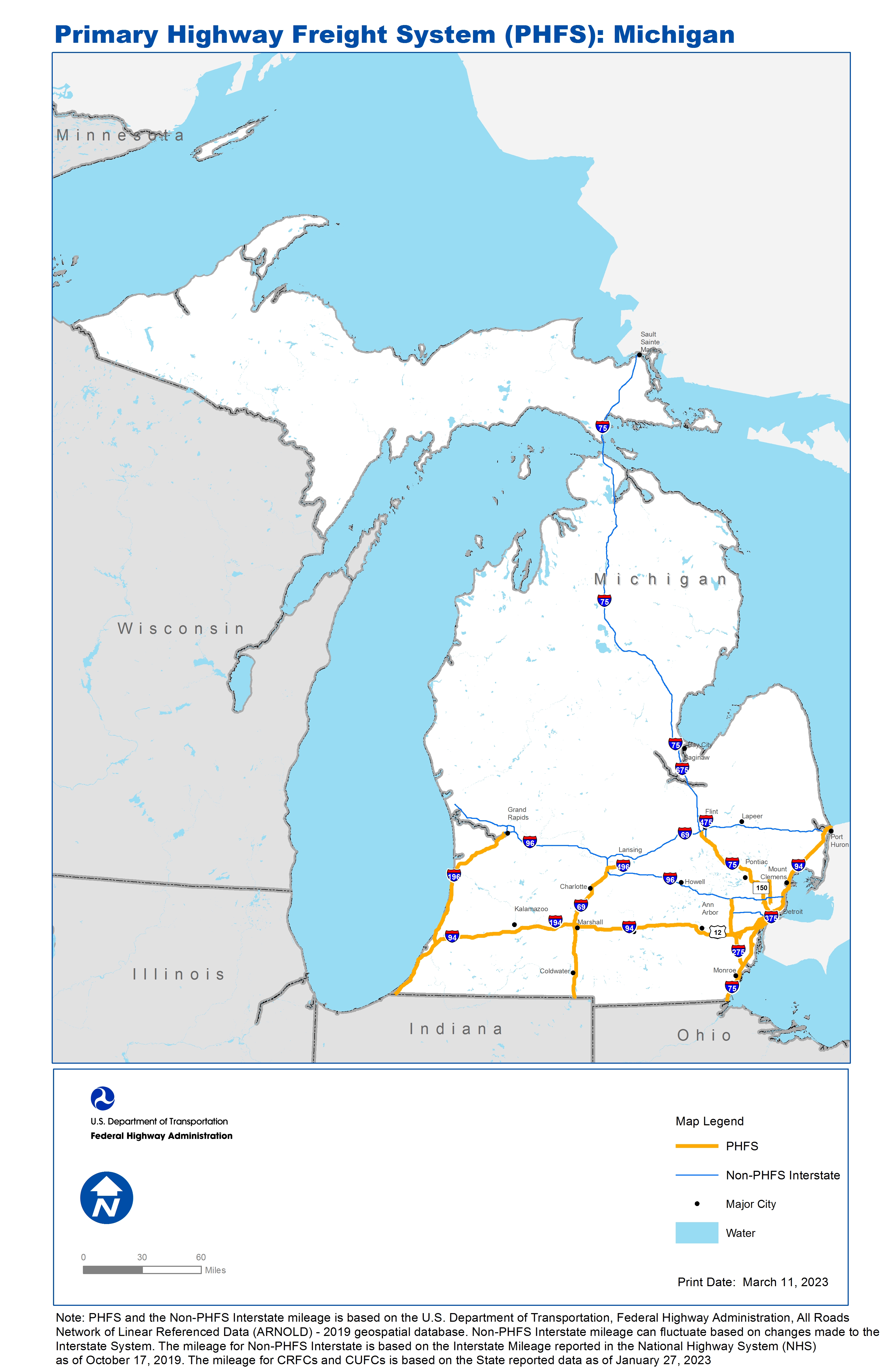
National Highway Freight Network Map and Tables for Michigan, 2022
High-Resolution Images
- JPG 3.0MB
Table of National Highway Freight Network Routes, 2022
State |
Route No/ Facility Name |
Start Point |
End Point |
Route/Facility Description |
Length (Miles) |
|---|---|---|---|---|---|
MI |
Big Beaver Rd |
S150 |
Metropolitan Pkwy |
Big Beaver Rd from S150 to Metropolitan Pkwy |
2.04 |
MI |
Ambassador Bridge |
I75 |
MI/ON Line |
Ambassador Bridge from I75 to MI/ON Line |
0.90 |
MI |
I196 |
I94 |
S45 |
I196 from I94 to S45 |
74.95 |
MI |
I275 |
I75 |
I96 |
I275 from I75 to I96 |
29.77 |
MI |
I496 |
I69 |
4.99 Miles East of I69 |
I496 from I69 to 4.99 Miles East of I69 |
5.11 |
MI |
I69 |
IN/MI Line |
I496 |
I69 from IN/MI Line to I496 |
74.37 |
MI |
I75 |
IN/MI Line |
I69 |
I75 from IN/MI Line to I69 |
116.01 |
MI |
I94 |
IN/MI Line |
MI/ON Line |
I94 from IN/MI Line to MI/ON Line |
275.45 |
MI |
I96 |
I275 |
I696 |
I96 from I275 to I696 |
6.69 |
MI |
Livernois Rd |
I75 |
W Jefferson Ave/MI3P |
Livernois Rd from I75 to W Jefferson Ave/MI3P |
0.55 |
MI |
Metropolitan Pkwy |
Big Beaver Rd |
Mound Rd |
Metropolitan Pkwy from Big Beaver Rd to Mound Rd |
2.03 |
MI |
Mound Rd |
S102 |
S59 |
Mound Rd from S102 to S59 |
12.23 |
MI |
S10 |
I75 |
I94 |
S10 from I75 to I94 |
1.74 |
MI |
S102 |
MI20R |
I75 |
S102 from MI20R to I75 |
1.17 |
MI |
S150 |
I75 |
Big Beaver Rd |
S150 from I75 to Big Beaver Rd |
0.23 |
MI |
Schaefer Hwy |
I75 |
W Jefferson Ave |
Schaefer Hwy from I75 to W Jefferson Ave |
1.34 |
MI |
W Jefferson Ave |
Schaefer Hwy |
Livernois Rd/MI3P |
W Jefferson Ave from Schaefer Hwy to Livernois Rd/MI3P |
2.75 |
MI |
West Rd |
MI39R |
I75 |
West Rd from MI39R to I75 |
0.80 |
MI |
Oakwood Blvd |
MI8P |
S85 |
Oakwood Blvd from MI8P to S85 |
0.92 |
MI |
S85 |
Oakwood Blvd |
MI7P |
S85 from Oakwood Blvd to MI7P |
0.15 |
MI |
MI10R - Norfolk Southern - Triple Crown |
I75 |
Norfolk Southern - Triple Crown |
S. Wabash St. to Dix Ave to Outer Dr. to Outer Dr. to Schaffer Hwy to I-75 |
1.52 |
MI |
MI18A - Detroit Metro Wayne County Airport |
I94 |
Detroit Metro Wayne County Airport |
Merriman Rd (Eureka to I-94) |
3.59 |
MI |
MI19A - Detroit - Willow Run Airport |
I94 |
Detroit - Willow Run Airport |
US 12 (Entrance to I-94) |
2.20 |
MI |
MI20R - Ferndale - CN North America Moterm |
S102 |
Ferndale - CN North America Moterm |
Fern St. (Terminal to Fair St.), Fair St. (Fern to M- 102) |
0.37 |
MI |
MI2R - Detroit Jct/Livernois Intermodal Ter. |
S153 |
Detroit Jct/Livernois Intermodal Ter. |
Mercier St. (Terminal to Wyoming and Dix Ave.), Wyoming Ave. (Mercier to S153) |
1.63 |
MI |
MI39R - Woodhaven - APL |
West Rd |
Woodhaven - APL |
King Rd. (Terminal to Allen Rd), Allen Rd (King Rd to West Rd.) |
1.28 |
MI |
MI3P - Lower Detroit River Port |
Fort St |
Lower Detroit River Port |
Jefferson Ave (Port to Dragoon). Clark Str. (Port to Fort St) |
1.09 |
MI |
MI41R - New Boston Auto Ramp |
I275 |
New Boston Auto Ramp |
Sibley Rd. (Terminal to I-275) |
0.45 |
MI |
MI5P - Lower River Rouge - Port #1 |
Jefferson Ave |
Lower River Rouge - Port #1 |
Marion Industrial Hwy (Port to Jefferson Ave.) |
0.57 |
MI |
MI6P - Lower River Rouge - Port #2 |
Jefferson Ave |
Lower River Rouge - Port #2 |
Brennan Ave. (Port to Jefferson Ave.) |
0.19 |
MI |
MI7P - Upper River Rouge - Port #1 |
Fort St |
Upper River Rouge - Port #1 |
Forman Ave to Flora St. to Reisner Ave. to Fort St |
0.37 |
MI |
MI8P - Upper River Rouge - Port #2 |
I75 |
Upper River Rouge - Port #2 |
Dix Ave. (Port to Livernois Ave), Oakwood (Dix to Schaffer), Schaffer Hwy (Oakwood to I-75), Dix Ave (Port to Livernois Ave) |
5.10 |
MI |
MI9R - Norfolk Southern - Oakwood |
I75 |
Norfolk Southern - Oakwood |
Hess St. (Terminal to Schaffer), Schaffer Hwy (Hess St to I-75) |
0.58 |
PHFS Total |
|
|
|
|
628.12 |
State |
Route No/ Facility Name |
Start Point |
End Point |
Route/Facility Description |
Length (Miles) |
|---|---|---|---|---|---|
MI |
I194 |
I94 |
S66 |
I194 from I94 to S66 |
3.42 |
MI |
I196 |
S45 |
I96 |
I196 from S45 to I96 |
5.70 |
MI |
I296 |
U131 |
I96 |
I296 from U131 to I96 |
3.32 |
MI |
I375 |
S10 |
I75 |
I375 from S10 to I75 |
1.23 |
MI |
I475 |
I75 (South) |
I75 (North) |
I475 from I75 (South) to I75 (North) |
16.87 |
MI |
I496 |
0.28 Miles West of S99 |
I96 |
I496 from 0.28 Miles West of S99 to I96 |
6.95 |
MI |
I675 |
I75 (South) |
I75 (North) |
I675 from I75 (South) to I75 (North) |
7.73 |
MI |
I69 |
I96 |
I94 |
I69 from I96 to I94 |
119.91 |
MI |
I696 |
I96 |
I94 |
I696 from I96 to I94 |
28.59 |
MI |
I75 |
I69 (End of PHFS route) |
MI/ON Line |
I75 from I69 (End of PHFS route) to MI/ON Line |
279.37 |
MI |
I96 |
U31 |
I496 (West) |
I96 from U31 to I496 (West) |
95.15 |
MI |
I96 |
I69 |
I696 |
I96 from I69 to I696 |
67.34 |
MI |
I96 |
I275 |
I75 |
I96 from I275 to I75 |
21.24 |
INTERSTATE NON-PHFS Total |
|
|
|
|
656.81 |
Note: PHFS and the Non-PHFS Interstate mileage is based on the U.S. Department of Transportation, Federal Highway Administration, All Roads Network of Linear Referenced Data (ARNOLD) - 2019 geospatial database. Non-PHFS Interstate mileage can fluctuate based on changes made to the Interstate System. The mileage for Non-PHFS Interstate is based on the Interstate Mileage reported in the National Highway System (NHS) as of October 17, 2019. The mileage for CRFCs and CUFCs is based on the State reported data as of January 27, 2023
Sources
U.S. Department of Transportation, Federal Highway Administration, All Roads Network of Linear Referenced Data (ARNOLD) 2019.