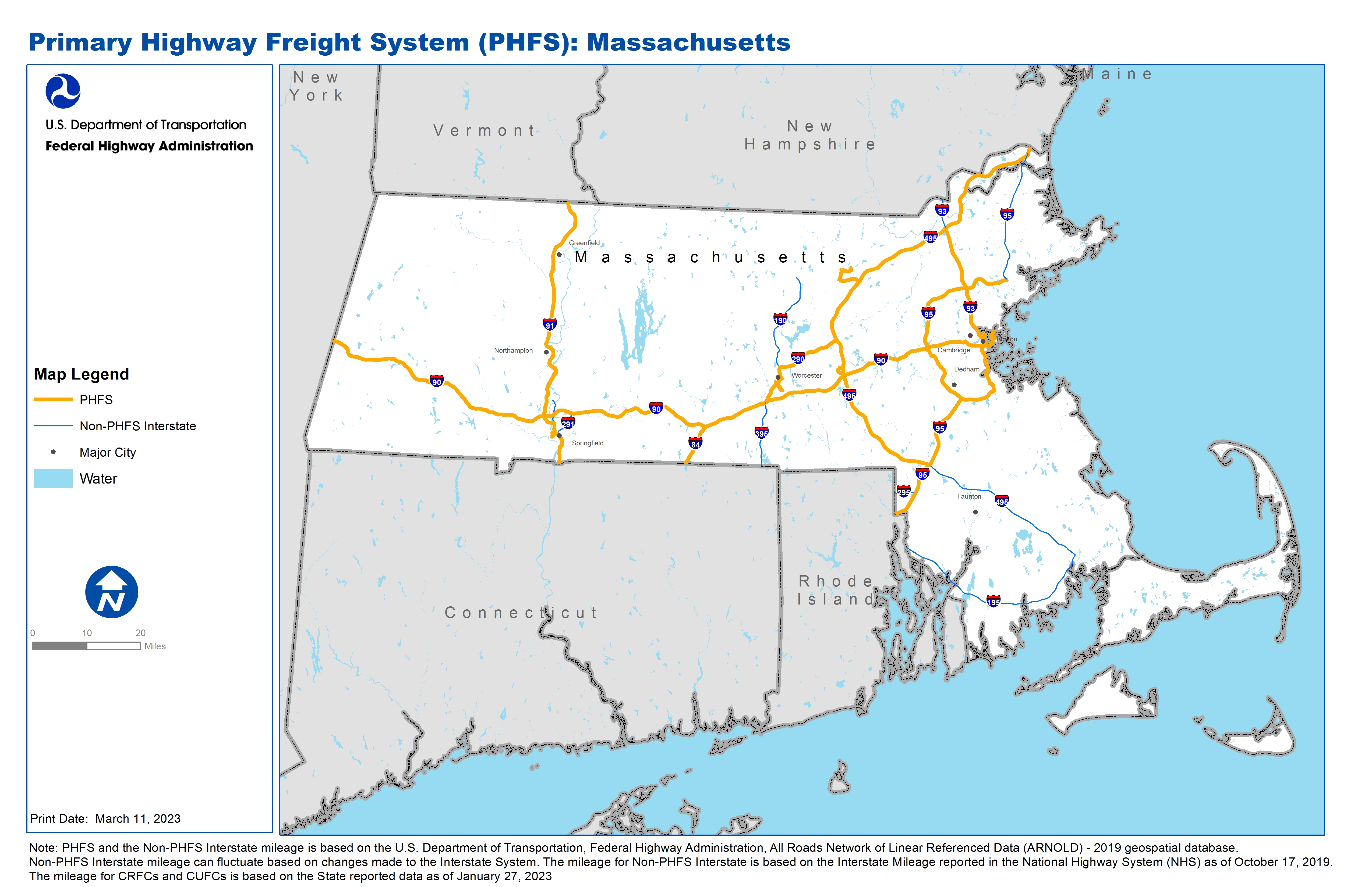
National Highway Freight Network Map and Tables for Massachusetts, 2022
High-Resolution Images
- JPG 3.6MB
Table of National Highway Freight Network Routes, 2022
State |
Route No/ Facility Name |
Start Point |
End Point |
Route/Facility Description |
Length (Miles) |
|---|---|---|---|---|---|
MA |
Cambridge St |
MA67R |
S146 |
Cambridge St from MA67R to S146 |
0.44 |
MA |
I290 |
I90 |
I495 |
I290 from I90 to I495 |
19.70 |
MA |
I495 |
I95 |
I95 |
I495 from I95 to I95 |
87.94 |
MA |
I84 |
CT/MA Line |
I90 |
I84 from CT/MA Line to I90 |
8.21 |
MA |
I90 |
NY/MA Line |
MA18A |
I90 from NY/MA Line to MA18A |
138.10 |
MA |
I91 |
CT/MA Line |
MA/VT Line |
I91 from CT/MA Line to MA/VT Line |
54.90 |
MA |
I93 |
I95 (South) |
I495 |
I93 from I95 (South) to I495 |
40.17 |
MA |
I95 |
RI/MA Line |
S128 |
I95 from RI/MA Line to S128 |
63.86 |
MA |
I95 |
I495 |
MA/NH Line |
I95 from I495 to MA/NH Line |
1.16 |
MA |
S146 |
MA68R |
Cambridge St |
S146 from MA68R to Cambridge St |
0.90 |
MA |
S110 |
S2A |
S2 |
S110 from S2A to S2 |
2.09 |
MA |
S2 |
S110 |
I495 |
S2 from S110 to I495 |
3.96 |
MA |
S9 |
MA61R |
I495 |
S9 from MA61R to I495 |
0.97 |
MA |
U1 |
MA19P |
I93 |
U1 from MA19P to I93 |
0.14 |
MA |
U20 |
MA59R |
I91 |
U20 from MA59R to I91 |
0.89 |
MA |
MA10R - Beacon Park Conrail RR Yard |
I90 |
Beacon Park Conrail RR Yard |
Yard to Cambridge St. to I-9 |
0.60 |
MA |
MA18A - Logan International Airport |
I90 |
Logan International Airport |
I90 to Main Airport Loop Rd. Airfield to South Gate to Harborside Dr to Main Airport Loop. Airfield to W Gate to Frankfort St to Prescott to Cottage St to SR 2 Main Airport Loop Rd. Connector 18A3 to Frankfort St to Neptune Rd to Bennington St to Rt |
3.37 |
MA |
MA19P - Moran Terminal - Port of Boston |
S99 |
Moran Terminal - Port of Boston |
Yard to Chelsea St Connector to Chelsea St to Rt 99 |
0.88 |
MA |
MA21P - Route 1A Petro Terminals - Boston (Various) |
S1A |
Route 1A Petro Terminals - Boston (Various) |
Chelsea St to Curtis St to Bremer St to Neptune St to Route 1A |
0.53 |
MA |
MA35R - Devens Intermodal Rail Terminal |
S110/111 |
Devens Intermodal Rail Terminal |
Barnum Rd. to Rt 110/111 |
0.31 |
MA |
MA3R - Ayer Boston & Maine RR Yard |
S110/111 |
Ayer Boston & Maine RR Yard |
Willow Rd to Route 2A/110 to Route 110/111 |
2.61 |
MA |
MA59R - W. Springfield Conrail Yard |
S20 |
W. Springfield Conrail Yard |
Yard to Day St. to Union St. to Rt 20 (Park Ave). . |
0.84 |
MA |
MA61R - Westborough CSX Auto Yard |
S9 |
Westborough CSX Auto Yard |
Walkup St to Flanders Rd to New Flanders Rd to Computer Dr to Route 9 ramps [2.25 mi]; Connector MA61R1 to Research Drive to Route 9 ramps [.15 mi] |
2.10 |
MA |
MA67R - Worcester P&WRR Yard - Southbridge St. |
Quinsigamond Ave |
Worcester P&WRR Yard - Southbridge St. |
Yard to Southbridge St. to Cambridge St Yard to Southbridge St. to Quinsigamond Ave |
0.73 |
MA |
MA68R - Worcester P&WRR Wiser Ave Yard |
S146 |
Worcester P&WRR Wiser Ave Yard |
Yard to Millbury St (NB) to Rt 146. Yard to Millbury St (SB) to Rt 146. . |
1.18 |
MA |
MA70R - Worcester TVT CSX Yard |
Grafton St |
Worcester TVT CSX Yard |
Franklin St to Grafton St |
0.50 |
PHFS Total |
|
|
|
|
437.08 |
State |
Route No/ Facility Name |
Start Point |
End Point |
Route/Facility Description |
Length (Miles) |
|---|---|---|---|---|---|
MA |
I190 |
I290 |
S2 |
I190 from I290 to S2 |
19.65 |
MA |
I195 |
RI/MA Line |
I495 |
I195 from RI/MA Line to I495 |
39.94 |
MA |
I291 |
I91 |
I90 |
I291 from I91 to I90 |
5.21 |
MA |
I295 |
RI/MA Line |
I95 |
I295 from RI/MA Line to I95 |
4.06 |
MA |
I391 |
I91 |
High St |
I391 from I91 to High St |
4.86 |
MA |
I395 |
CT/MA Line |
I90 |
I395 from CT/MA Line to I90 |
12.28 |
MA |
I495 |
I195 |
I95 |
I495 from I195 to I95 |
32.87 |
MA |
I93 |
I495 |
MA/NH Line |
I93 from I495 to MA/NH Line |
5.76 |
MA |
I95 |
S128 |
I495 |
I95 from S128 to I495 |
25.12 |
INTERSTATE NON-PHFS Total |
|
|
|
|
149.75 |
Note: PHFS and the Non-PHFS Interstate mileage is based on the U.S. Department of Transportation, Federal Highway Administration, All Roads Network of Linear Referenced Data (ARNOLD) - 2019 geospatial database. Non-PHFS Interstate mileage can fluctuate based on changes made to the Interstate System. The mileage for Non-PHFS Interstate is based on the Interstate Mileage reported in the National Highway System (NHS) as of October 17, 2019. The mileage for CRFCs and CUFCs is based on the State reported data as of January 27, 2023
Sources
U.S. Department of Transportation, Federal Highway Administration, All Roads Network of Linear Referenced Data (ARNOLD) 2019.