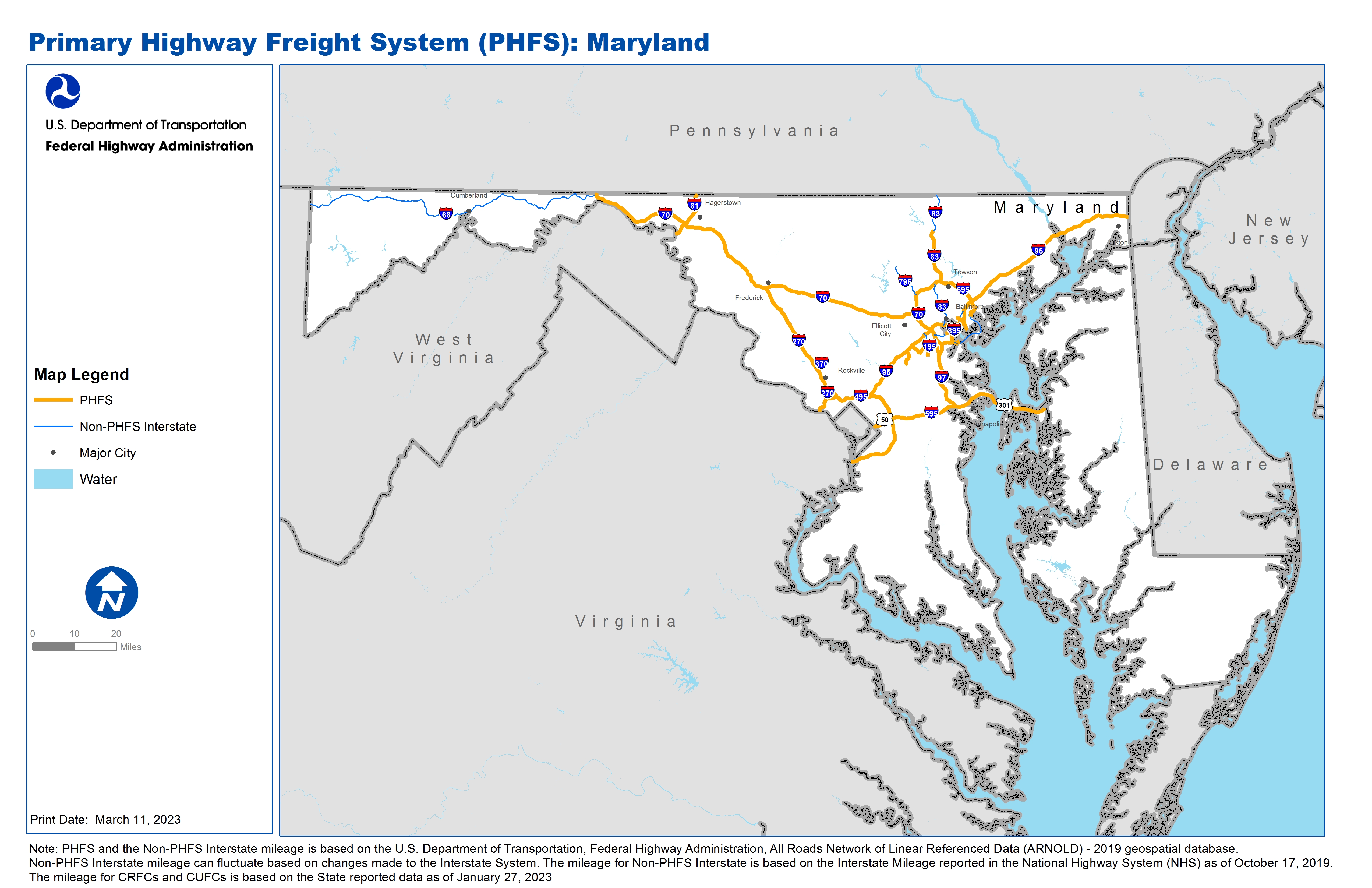
National Highway Freight Network Map and Tables for Maryland, 2022
High-Resolution Images
- JPEG 3.6MB
Table of National Highway Freight Network Routes, 2022
State |
Route No/ Facility Name |
Start Point |
End Point |
Route/Facility Description |
Length (Miles) |
|---|---|---|---|---|---|
MD |
I195 |
MD50A |
S295 |
I195 from MD50A to S295 |
1.04 |
MD |
I270 |
I70 |
I495 |
I270 from I70 to I495 |
34.35 |
MD |
I495 |
VA/MD Line |
I95 |
I495 from VA/MD Line to I95 |
16.11 |
MD |
I595 |
I495 |
S70 |
I595 from I495 to S70 |
20.83 |
MD |
I695 |
M40L |
S150 (From the North) |
I695 from M40L to S150 (From the North) |
38.83 |
MD |
I70 |
PA/MD Line |
I695 |
I70 from PA/MD Line to I695 |
91.51 |
MD |
I81 |
WV/MD Line |
MD/PA Line |
I81 from WV/MD Line to MD/PA Line |
12.05 |
MD |
I83 |
I695 |
0.33 North of S138 |
I83 from I695 to 0.33 North of S138 |
13.32 |
MD |
I95 |
DC/MD Line |
MD/DE Line |
I95 from DC/MD Line to MD/DE Line |
108.30 |
MD |
I97 |
I595 |
I695 |
I97 from I595 to I695 |
17.43 |
MD |
S100 |
I95 |
S295 |
S100 from I95 to S295 |
2.69 |
MD |
S201 |
MD/DC Line |
U50 |
S201 from MD/DC Line to U50 |
0.47 |
MD |
S295 |
S100 |
I195 |
S295 from S100 to I195 |
2.92 |
MD |
U301 |
I595 |
U50-U301 Split in Queenstown |
U301 from I595 to U50-U301 Split in Queenstown |
20.64 |
MD |
U50 |
S201 |
I495 |
U50 from S201 to I495 |
4.78 |
MD |
MD38R - CSX Intermodal Container Facility |
MD46P |
CSX Intermodal Container Facility |
Vail St (Keith to CSX Gate), New Vail St (Keith to Newgate), Keith Ave MU5857 (Broening to Clinton) |
1.69 |
MD |
MD39R - Norfolk Southern Bayview Intermodal Container Transfer Facility |
I95 |
Norfolk Southern Bayview Intermodal Container Transfer Facility |
Eastern Ave (I-95 to Ponca), Ponca St (Eastern to Lombard), Lombard (Kane to Haven), Kane St (Northpoint to Dundalk), Northpoint Blvd (I-695 to Kane), Haven/Kresson Street (Lombard to Pulaski) |
2.22 |
MD |
MD40L - Shell/Motiva Facility |
MD47P |
Shell/Motiva Facility |
E. Patapsco Ave (Pennington to Fairfield), Fairfield Rd (Patapsco to Northbridge), Northbridge Ave (Fairfield to Asiatic), Asiatic Ave (Northbridge to shell Oil). Pennington/Curtis Avenues (Birch to Patapsco), Birch St (Pennington to Curtis). Hanover/P |
5.49 |
MD |
MD42P - Dundalk/Seagirt Marine Terminal |
I95 |
Dundalk/Seagirt Marine Terminal |
Dundalk Ave (Holabird to Eastern), Holabird Ave (Ponca to Dundalk) |
3.86 |
MD |
MD43P - Locust Point Terminals |
I95 |
Locust Point Terminals |
McComas St-MU 4320 (Hanover to end of street). |
2.27 |
MD |
MD46P - Rukert/Hale Intermodal Terminal |
MD38R |
Rukert/Hale Intermodal Terminal |
Clinton St (Boston to Keith) Access to this terminal is provided by Keith Ave, listed under MD38R; Newkirk St (Newgate St to Boston); Newgate St (New Vail to end) |
2.34 |
MD |
MD47P - Fairfield Auto Terminals |
I895 |
Fairfield Auto Terminals |
Frankfurt Ave (Hanover to Vera), Vera St (Frankfurt to Chesapeake), Chesapeake Ave (Vera to Fairfield), Child’s St (Frankfurt to Terminal) |
2.65 |
MD |
MD48P - Hawkins Point Marine Terminal |
MD40L |
Hawkins Point Marine Terminal |
Pennington Ave/ Hawkins point Rd (Birch to Anne Arundel County), Quarantine Rd (Hawkins Pt to Terminal) |
0.56 |
MD |
MD50A - BWI Airport |
I97 |
BWI Airport |
Camp Meade Rd (Dorsey to Aviation), Aviation Blvd (Camp Meade to I-97) |
6.11 |
MD |
MD60R - Jessup Auto Distribution Facility |
I95 |
Jessup Auto Distribution Facility |
Dorsey Run Rd (MD 175 to MD 32), MD 175 (I-95 to Dorsey Run Rd) |
3.96 |
PHFS Total |
|
|
|
|
416.41 |
State |
Route No/ Facility Name |
Start Point |
End Point |
Route/Facility Description |
Length (Miles) |
|---|---|---|---|---|---|
MD |
I195 |
S166 |
S295 |
I195 from S166 to S295 |
3.13 |
MD |
I195 |
S170 |
0.53 Miles South of S170 |
I195 from S170 to 0.53 Miles South of S170 |
0.53 |
MD |
I295 |
DC/MD Line |
S210 |
I295 from DC/MD Line to S210 |
0.81 |
MD |
I370 |
I270 |
0.37 Miles East of Mid County Hwy |
I370 from I270 to 0.37 Miles East of Mid County Hwy |
2.11 |
MD |
I395 |
I95 |
W Conway St |
I395 from I95 to W Conway St |
1.33 |
MD |
I68 |
WV/MD Line |
I70 |
I68 from WV/MD Line to I70 |
80.60 |
MD |
I695 |
S173 |
S150 |
I695 from S173 to S150 |
12.69 |
MD |
I70 |
I695 |
S122 |
I70 from I695 to S122 |
1.80 |
MD |
I795 |
I695 |
S140 |
I795 from I695 to S140 |
8.96 |
MD |
I83 |
E Fayette St |
I695 |
I83 from E Fayette St to I695 |
9.68 |
MD |
I83 |
0.33 North of S138 |
PA/MD Line |
I83 from 0.33 North of S138 to PA/MD Line |
9.77 |
MD |
I895 |
I695 |
I95 (North) |
I895 from I695 to I95 (North) |
11.12 |
INTERSTATE NON-PHFS Total |
|
|
|
|
142.52 |
Note: PHFS and the Non-PHFS Interstate mileage is based on the U.S. Department of Transportation, Federal Highway Administration, All Roads Network of Linear Referenced Data (ARNOLD) - 2019 geospatial database. Non-PHFS Interstate mileage can fluctuate based on changes made to the Interstate System. The mileage for Non-PHFS Interstate is based on the Interstate Mileage reported in the National Highway System (NHS) as of October 17, 2019. The mileage for CRFCs and CUFCs is based on the State reported data as of January 27, 2023
Sources
U.S. Department of Transportation, Federal Highway Administration, All Roads Network of Linear Referenced Data (ARNOLD) 2019.