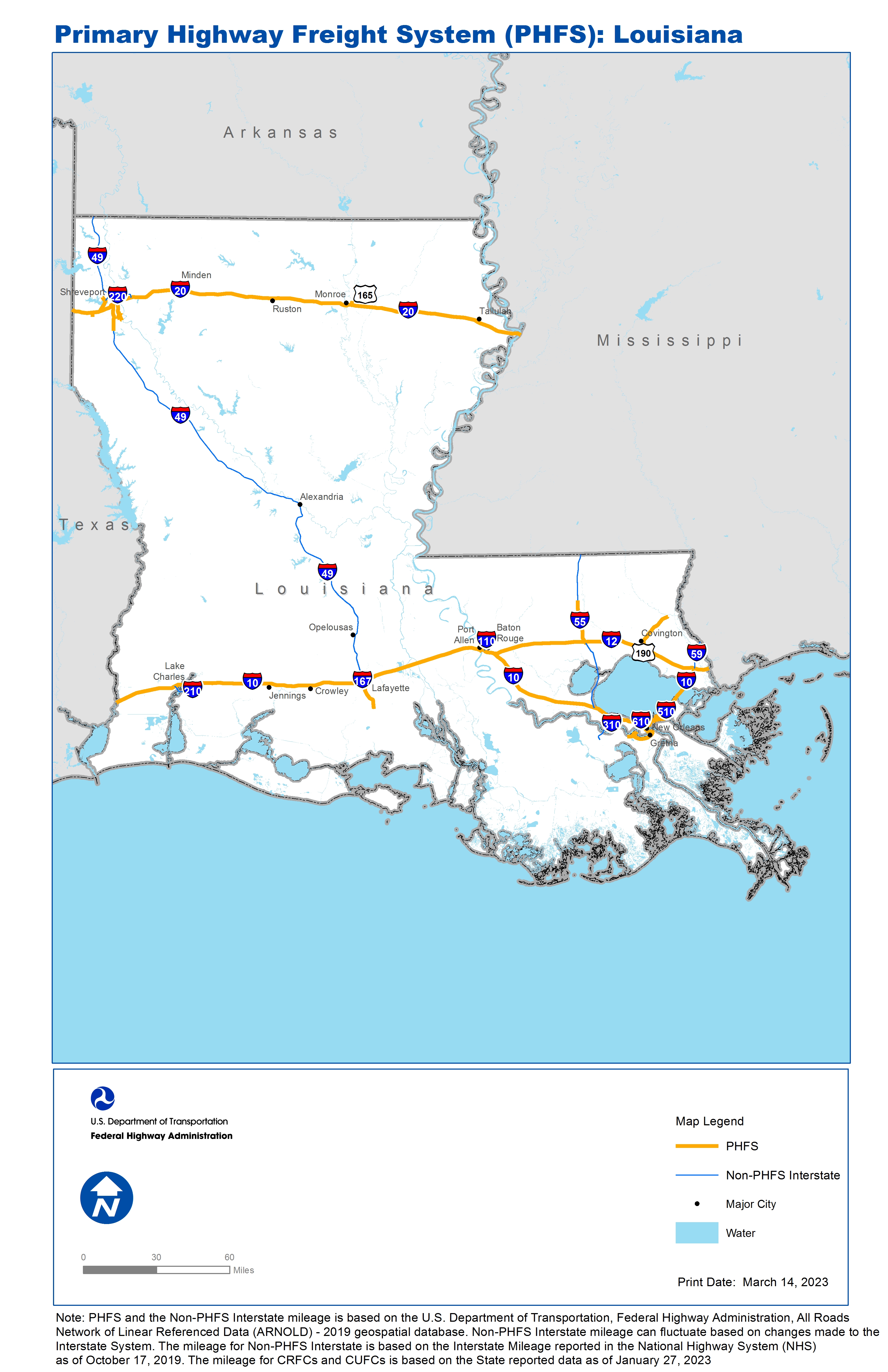
National Highway Freight Network Map and Tables for Louisiana, 2022

High-Resolution Images
- JPG 3.5MB
Table of National Highway Freight Network Routes, 2022
State |
Route No/ Facility Name |
Start Point |
End Point |
Route/Facility Description |
Length (Miles) |
|---|---|---|---|---|---|
LA |
Causeway Blvd |
U61 |
I10 |
Causeway Blvd from U61 to I10 |
1.55 |
LA |
I10 |
TX/LA Line |
LA/MS Line |
I10 from TX/LA Line to LA/MS Line |
273.90 |
LA |
I12 |
I10 |
I10 |
I12 from I10 to I10 |
86.62 |
LA |
I20 |
TX/LA Line |
LA/MS Line |
I20 from TX/LA Line to LA/MS Line |
189.90 |
LA |
I220 |
LA27R |
I20 |
I220 from LA27R to I20 |
4.96 |
LA |
I310 |
U61 |
I10 |
I310 from U61 to I10 |
2.97 |
LA |
I49 |
I10 |
0.36 Miles North of I10 |
I49 from I10 to 0.36 Miles North of I10 |
0.36 |
LA |
I49 |
I20 |
11.04 Miles South of I20 |
I49 from I20 to 11.04 Miles South of I20 |
11.04 |
LA |
I55 |
U51 |
S16 |
I55 from U51 to S16 |
18.28 |
LA |
I610 |
I10 |
I10 |
I610 from I10 to I10 |
4.92 |
LA |
I910 |
I10 |
U90 |
I910 from I10 to U90 |
9.79 |
LA |
Jourdan Rd |
LA15R/LA17P |
U90 |
Jourdan Rd from LA15R/LA17P to U90 |
0.25 |
LA |
N Causeway Blvd |
U190 |
1.67 Miles South of U190 |
N Causeway Blvd from U190 to 1.67 Miles South of U190 |
1.67 |
LA |
S1 |
I10 |
0.54 Miles South of I10 |
S1 from I10 to 0.54 Miles South of I10 |
0.54 |
LA |
S1 |
I20 |
0.21 Miles North of S 523 |
S1 from I20 to 0.21 Miles North of S 523 |
8.44 |
LA |
S21 |
U190 |
14.59 Miles North of U190 |
S21 from U190 to 14.59 Miles North of U190 |
14.48 |
LA |
S3184 |
I10 |
0.19 Miles South of S3184 |
S3184 from I10 to 0.19 Miles South of S3184 |
0.25 |
LA |
S39 |
I10 |
S46 |
S39 from I10 to S46 |
0.50 |
LA |
S46 |
LA18P |
S39 |
S46 from LA18P to S39 |
0.34 |
LA |
S526 |
Inner loop Exwy |
70th Street |
S526 from Inner loop Exwy to 70th Street |
2.84 |
LA |
U165 |
U80 |
0.43 Miles South of I20 |
U165 from U80 to 0.43 Miles South of I20 |
2.04 |
LA |
U167 |
I10 |
U90 South |
U167 from I10 to U90 South |
1.84 |
LA |
U190 |
N Causeway Blvd |
S21 |
U190 from N Causeway Blvd to S21 |
5.90 |
LA |
U61 |
LA9A |
I310 |
U61 from LA9A to I310 |
3.28 |
LA |
U61 |
S Labarre Rd |
Causeway Blvd |
U61 from S Labarre Rd to Causeway Blvd |
0.26 |
LA |
U90 |
U167 |
0.17 Miles South of S3168 |
U90 from U167 to 0.17 Miles South of S3168 |
11.17 |
LA |
U90 |
Avondale Garden Rd |
LA11R |
U90 from Avondale Garden Rd to LA11R |
3.55 |
LA |
U90 |
U90 |
I910 |
U90 from U90 to I910 |
3.60 |
LA |
U90 |
Jourdan Rd |
I10 |
U90 from Jourdan Rd to I10 |
0.69 |
LA |
LA11R - BNSF - Westwego Terminal |
U90 |
BNSF - Westwego Terminal |
Bridge City Ave {LA 18} (Terminal to US 90) |
1.27 |
LA |
LA14R - Norfolk Southern - New Orleans Ter. |
S46 |
Norfolk Southern - New Orleans Ter. |
Florida Ave. (Terminal to LA 46 |
0.92 |
LA |
LA15R - CSX - New Orleans terminal |
I510 |
CSX - New Orleans terminal |
Almonaster Rd (Terminal to Alvar Rd). Almonaster Ave (Terminal to I-510). . |
5.21 |
LA |
LA17P - Port of New Orleans - Jourdan Road Ter. |
Almonaster Rd |
Port of New Orleans - Jourdan Road Ter. |
Jourdan Rd. (Terminal to Almonaster Rd.) |
0.77 |
LA |
LA19P - Port of New Orleans - Miss. River Term. |
U90 |
Port of New Orleans - Miss. River Term. |
Felicity St (Terminal to Religious St), Religious St (Felicity to Euterpe), Tchoupitoulas St (Felicity to US 90) |
0.79 |
LA |
LA23R - Union Pacific - Reisor Terminal |
I20 |
Union Pacific - Reisor Terminal |
LA 526 (Terminal to I-20) |
1.81 |
LA |
LA27R - KCS - Deramus Yard |
I220 |
KCS - Deramus Yard |
LA 173 (Terminal to I-220) |
1.91 |
LA |
LA9A - New Orleans International Airport |
U61 |
New Orleans International Airport |
Airport Rd. (Entrance to Veterans Memorial Blvd), Veterans Mem Blvd (Airport Rd. to LA 49). Crofton Rd. (Entrance to US 61) |
0.40 |
PHFS Total |
|
|
|
|
679.01 |
State |
Route No/ Facility Name |
Start Point |
End Point |
Route/Facility Description |
Length (Miles) |
|---|---|---|---|---|---|
LA |
I110 |
U61 |
I10 |
I110 from U61 to I10 |
8.73 |
LA |
I210 |
I10 (West) |
I10 (East) |
I210 from I10 (West) to I10 (East) |
12.69 |
LA |
I220 |
S173 |
I20 |
I220 from S173 to I20 |
12.65 |
LA |
I310 |
U90 |
U61 |
I310 from U90 to U61 |
8.70 |
LA |
I49 |
0.36 Miles North of I10 |
11.04 Miles South of I20 |
I49 from 0.36 Miles North of I10 to 11.04 Miles South of I20 |
195.40 |
LA |
I510 |
U90 |
I10 |
I510 from U90 to I10 |
3.04 |
LA |
I55 |
I10 |
U51 |
I55 from I10 to U51 |
28.72 |
LA |
I55 |
S16 |
LA/MS Line |
I55 from S16 to LA/MS Line |
18.98 |
LA |
I59 |
I10 |
LA/MS Line |
I59 from I10 to LA/MS Line |
11.46 |
LA |
I49 |
I220 |
AR/LA Line |
I49 from I220 to AR/LA Line |
36.16 |
INTERSTATE NON-PHFS Total |
336.53 |
Note: PHFS and the Non-PHFS Interstate mileage is based on the U.S. Department of Transportation, Federal Highway Administration, All Roads Network of Linear Referenced Data (ARNOLD) - 2019 geospatial database. Non-PHFS Interstate mileage can fluctuate based on changes made to the Interstate System. The mileage for Non-PHFS Interstate is based on the Interstate Mileage reported in the National Highway System (NHS) as of October 17, 2019. The mileage for CRFCs and CUFCs is based on the State reported data as of January 27, 2023
Sources
U.S. Department of Transportation, Federal Highway Administration, All Roads Network of Linear Referenced Data (ARNOLD) 2019.