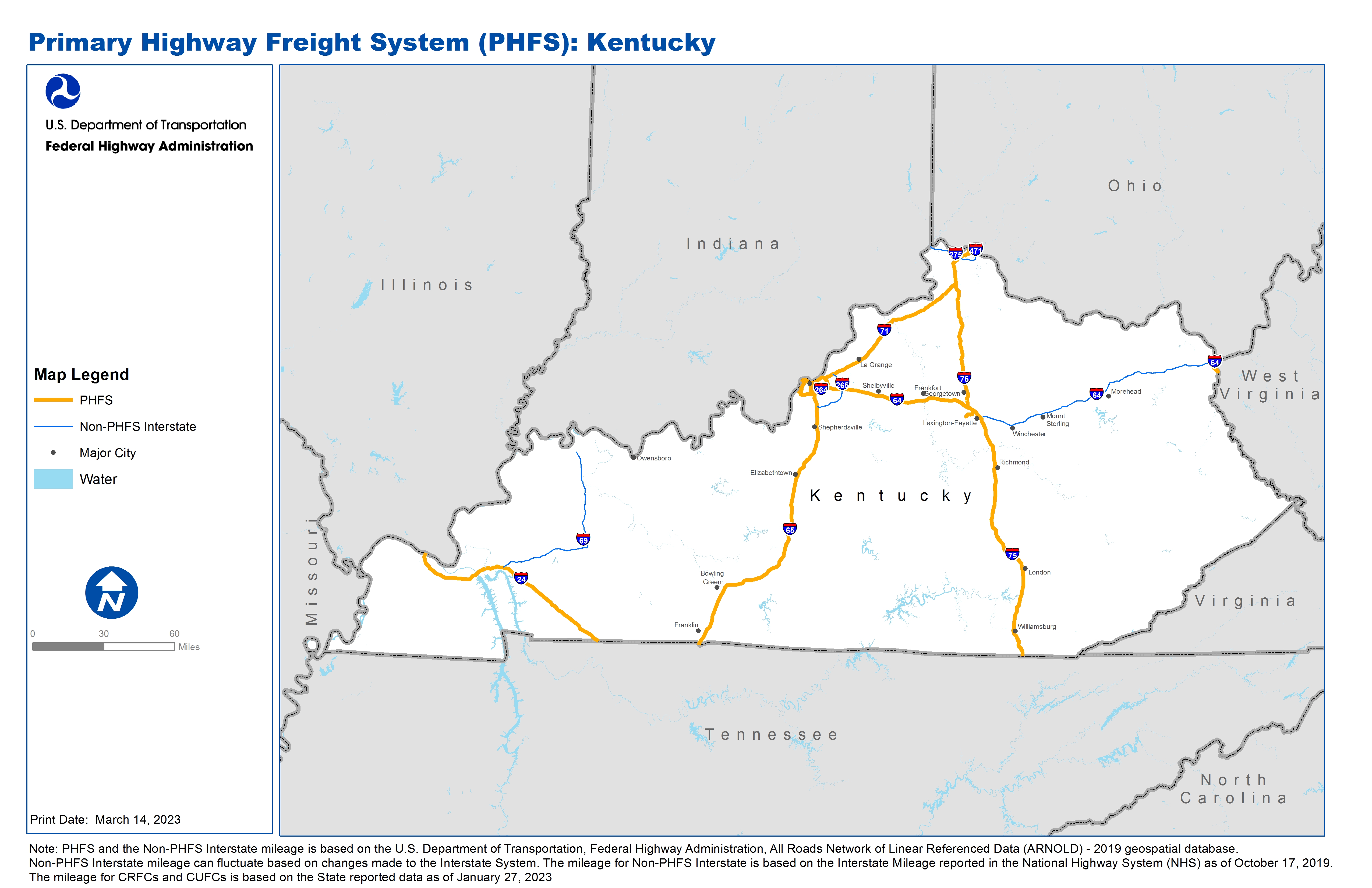
National Highway Freight Network Map and Tables for Kentucky, 2022
High-Resolution Images
- JPG 2.8MB
Table of National Highway Freight Network Routes, 2022
|
State |
Route No/ Facility Name |
Start Point |
End Point |
Route/Facility Description |
Length (Miles) |
|---|---|---|---|---|---|
KY |
I24 |
IL/KY Line |
KY/TN Line |
I24 from IL/KY Line to KY/TN Line |
93.31 |
KY |
I264 |
I64 |
I71 |
I264 from I64 to I71 |
22.91 |
KY |
I265 |
I64 |
4.51 Miles North of I64 |
I265 from I64 to 4.51 Miles North of I64 |
4.56 |
KY |
I275 |
KY10A |
I71 |
I275 from KY10A to I71 |
3.98 |
KY |
I64 |
IN/KY Line |
I65 |
I64 from IN/KY Line to I65 |
5.93 |
KY |
I64 |
I264 |
I75 |
I64 from I264 to I75 |
62.55 |
KY |
I64 |
U23 |
KY/WV Line |
I64 from U23 to KY/WV Line |
0.72 |
KY |
I65 |
TN/KY Line |
KY/IN Line |
I65 from TN/KY Line to KY/IN Line |
137.28 |
KY |
I71 |
I64 |
OH/KY Line |
I71 from I64 to OH/KY Line |
96.02 |
KY |
I75 |
TN/KY Line |
I71 |
I75 from TN/KY Line to I71 |
173.56 |
KY |
S1934 |
KY5L |
I264 |
S1934 from KY5L to I264 |
0.52 |
KY |
S4 |
KY12L |
S922 |
S4 from KY12L to S922 |
3.01 |
KY |
S922 |
S4 |
I75 |
S922 from S4 to I75 |
1.83 |
KY |
U23 |
S757 |
I64 |
U23 from S757 to I64 |
4.55 |
KY |
KY10A - Cincinnati/N KY International Airport |
I275 |
Cincinnati/N KY International Airport |
KY 212 from I-275 S to the Airport Roadway System |
0.84 |
KY |
KY12L - Louisville/Ashland Oil/Chevron Dist. Center |
S4 |
Louisville/Ashland Oil/Chevron Dist. Center |
KY 1681 - KY 4 Interchange to Facility |
0.29 |
KY |
KY15P - Truck to Barge Coal Dock Cluster, Boyd Cnty |
U23 |
Truck to Barge Coal Dock Cluster, Boyd Cnty |
KY 757 from US 23 near Lockwood to 2.45 Miles North |
2.45 |
KY |
KY5L - Campground Rd Petroleum Pipeline |
S1934 |
Campground Rd Petroleum Pipeline |
Campground Rd (Cane Run to Ralph), Kramers Ln (Cane Run to Campground), Ralph Ave (Cane Run to Campground Rd) |
0.86 |
KY |
KY6L - Bells Lane Petroleum/Chemical Pipeline |
I264 |
Bells Lane Petroleum/Chemical Pipeline |
KY 2056 from I-264 W to the Louisville-Ohio River Floodwall |
1.04 |
KY |
KY8A - Louisville International Airport |
I264 |
Louisville International Airport |
Grade Ln (I-264 to UPS Feeder Truck Entrance) |
1.23 |
KY |
KY9R - Norfolk Southern Intermodal - Louisville |
I264 |
Norfolk Southern Intermodal - Louisville |
Newburg Rd (I-264 to Bishop), Bishop Ln (Newburg to Jennings), Jennings Ln (Bishop to Facility) |
1.13 |
PHFS Total |
|
|
|
|
618.57 |
|
State |
Route No/ Facility Name |
Start Point |
End Point |
Route/Facility Description |
Length (Miles) |
|---|---|---|---|---|---|
KY |
I265 |
I65 |
I64 |
I265 from I65 to I64 |
15.21 |
KY |
I265 |
0.40 Miles South of S146 |
I71 |
I265 from 0.40 Miles South of S146 to I71 |
4.69 |
KY |
I275 |
IN/KY Line |
S212 |
I275 from IN/KY Line to S212 |
9.93 |
KY |
I275 |
I71 |
KY/OH Line |
I275 from I71 to KY/OH Line |
10.75 |
KY |
I471 |
I275 |
KY/OH Line |
I471 from I275 to KY/OH Line |
4.86 |
KY |
I64 |
I71 |
I264 |
I64 from I71 to I264 |
6.34 |
KY |
I64 |
I75 |
U23 |
I64 from I75 to U23 |
109.37 |
KY |
I69 |
I24 |
US41 |
I69 from I24 to US41 |
80.12 |
INTERSTATE NON-PHFS Total |
241.27 |
Note: “PHFS and the Non-PHFS Interstate mileage is based on the U.S. Department of Transportation, Federal Highway Administration, All Roads Network of Linear Referenced Data (ARNOLD) - 2019 geospatial database.
Non-PHFS Interstate mileage can fluctuate based on changes made to the Interstate System. The mileage for CRFCs and CUFCs is from June 2022. The fields for CRFCs and CUFCs will be updated periodically to reflect designation on a rolling basis.”
Sources
U.S. Department of Transportation, Federal Highway Administration, All Roads Network of Linear Referenced Data (ARNOLD) 2019.