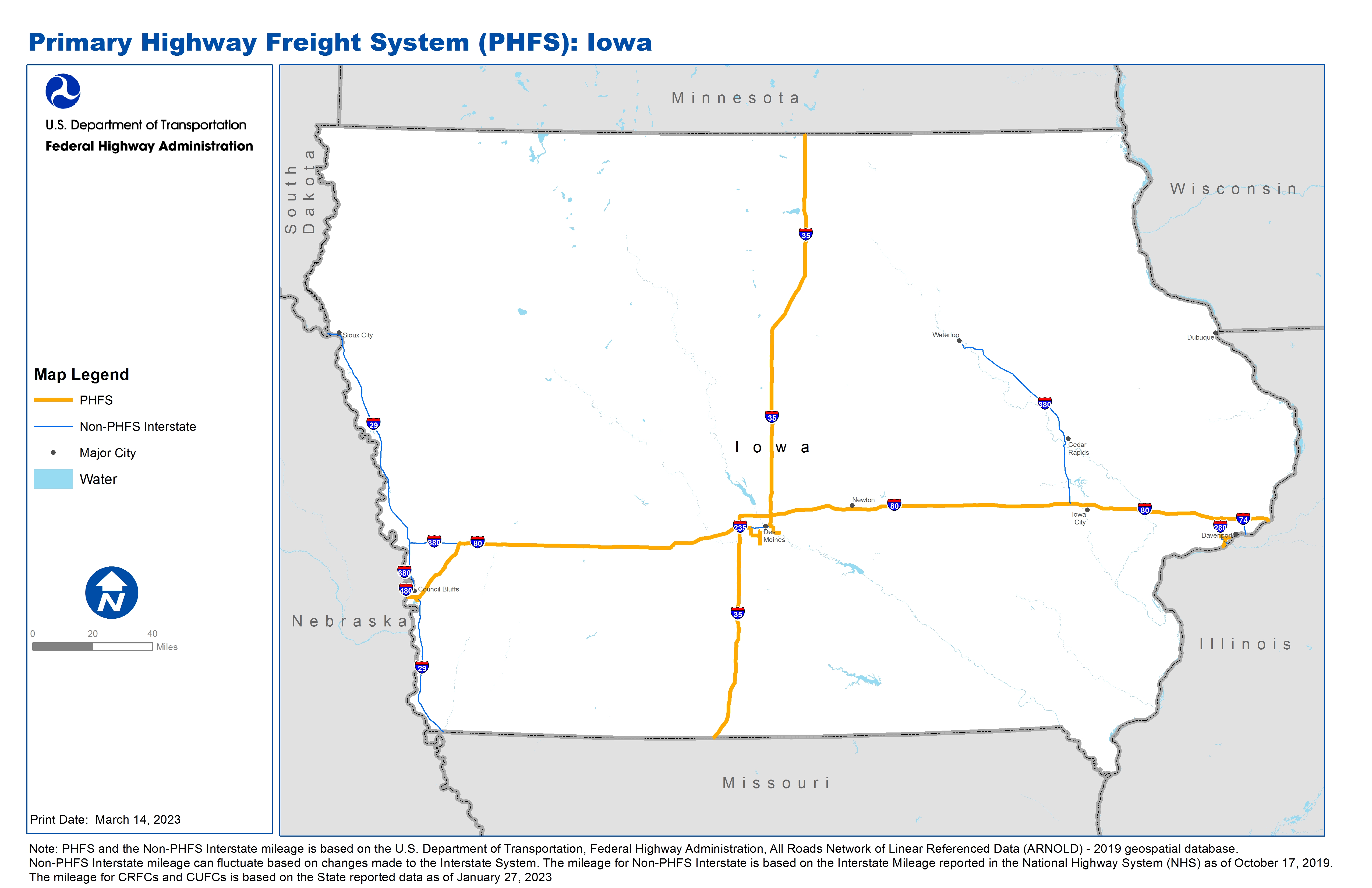
National Highway Freight Network Map and Tables for Iowa, 2022

High-Resolution Images
- JPG 2.2MB
Table of National Highway Freight Network Routes, 2022
|
State |
Route No/ Facility Name |
Start Point |
End Point |
Route/Facility Description |
Length (Miles) |
|---|---|---|---|---|---|
IA |
I235 |
I35 |
S28 |
I235 from I35 to S28 |
3.82 |
IA |
I235 |
S163 |
I80 |
I235 from S163 to I80 |
3.65 |
IA |
I280 |
U61 |
I80 |
I280 from U61 to I80 |
6.84 |
IA |
I29 |
I80 |
I80 |
I29 from I80 to I80 |
2.96 |
IA |
I35 |
MO/IA Line |
IA/MN Line |
I35 from MO/IA Line to IA/MN Line |
218.57 |
IA |
I80 |
NE/IA Line |
I29 |
I80 from NE/IA Line to I29 |
0.89 |
IA |
I80 |
I29 |
I35 |
I80 from I29 to I35 |
118.71 |
IA |
I80 |
I35 |
IA/IL Line |
I80 from I35 to IA/IL Line |
168.96 |
IA |
S163 |
S46 |
I235 |
S163 from S46 to I235 |
1.41 |
IA |
S28 |
IA7A or Park Ave |
I235 |
S28 from IA7A or Park Ave to I235 |
2.59 |
IA |
S461 |
IA4R |
I280 |
S461 from IA4R to I280 |
1.65 |
IA |
IA4R - Quad Cities Container Terminal, Davenport |
S461 |
Quad Cities Container Terminal, Davenport |
S Rolff St, Rockingham Rd (IA 22), between the Terminal and I-280 |
2.42 |
IA |
IA5P - Harvest States Peavey, Davenport |
I280 |
Harvest States Peavey, Davenport |
IA 22 between the Terminal and I-280 |
2.19 |
IA |
IA6L - Amoco Pipeline Distribution Center, Council Bluffs |
I29 |
Amoco Pipeline Distribution Center, Council Bluffs |
US 275 (eastern ramp termini I-29 to South Expressway), then North to the Westbound ramp terminus of I-29/80 |
1.92 |
IA |
IA7A - Des Moines International Airport |
S28 |
Des Moines International Airport |
Fleur Dr between ML King Blvd and relocated IA 5. Park Ave (63rd to Fleur Dr) |
8.05 |
IA |
IA9L - Vandalia Rd Pipeline, Des Moines |
S163 |
Vandalia Rd Pipeline, Des Moines |
E. 30th St/Vandalia Rd (IA 163 to US 65) |
4.36 |
PHFS Total |
|
|
|
|
549.01 |
State |
Route No/ Facility Name |
Start Point |
End Point |
Route/Facility Description |
Length (Miles) |
|---|---|---|---|---|---|
IA |
I129 |
NE/IA Line |
I29 |
I129 from NE/IA Line to I29 |
0.29 |
IA |
I235 |
S28 |
S163 |
I235 from S28 to S163 |
6.26 |
IA |
I280 |
U61 |
IA/IL Line |
I280 from U61 to IA/IL Line |
3.03 |
IA |
I29 |
MO/IA Line |
I80 (East) |
I29 from MO/IA Line to I80 (East) |
48.83 |
IA |
I29 |
I80 (West) |
SD Line |
I29 from I80 (West) to SD Line |
100.18 |
IA |
I380 |
U218 |
I80 |
I380 from U218 to I80 |
73.00 |
IA |
I480 |
NE/IA Line |
I29 |
I480 from NE/IA Line to I29 |
0.76 |
IA |
I680 |
NE/IA Line |
I29 |
I680 from NE/IA Line to I29 |
3.06 |
IA |
I880 |
I80 |
I29 (South) |
I880 from I80 to I29 (South) |
17.11 |
IA |
I74 |
I80 |
IA/IL Line |
I74 from I80 to IA/IL Line |
5.36 |
INTERSTATE NON-PHFS Total |
|
|
|
|
257.88 |
Note: PHFS and the Non-PHFS Interstate mileage is based on the U.S. Department of Transportation, Federal Highway Administration, All Roads Network of Linear Referenced Data (ARNOLD) - 2019 geospatial database. Non-PHFS Interstate mileage can fluctuate based on changes made to the Interstate System. The mileage for Non-PHFS Interstate is based on the Interstate Mileage reported in the National Highway System (NHS) as of October 17, 2019. The mileage for CRFCs and CUFCs is based on the State reported data as of January 27, 2023
Sources
U.S. Department of Transportation, Federal Highway Administration, All Roads Network of Linear Referenced Data (ARNOLD) 2019.