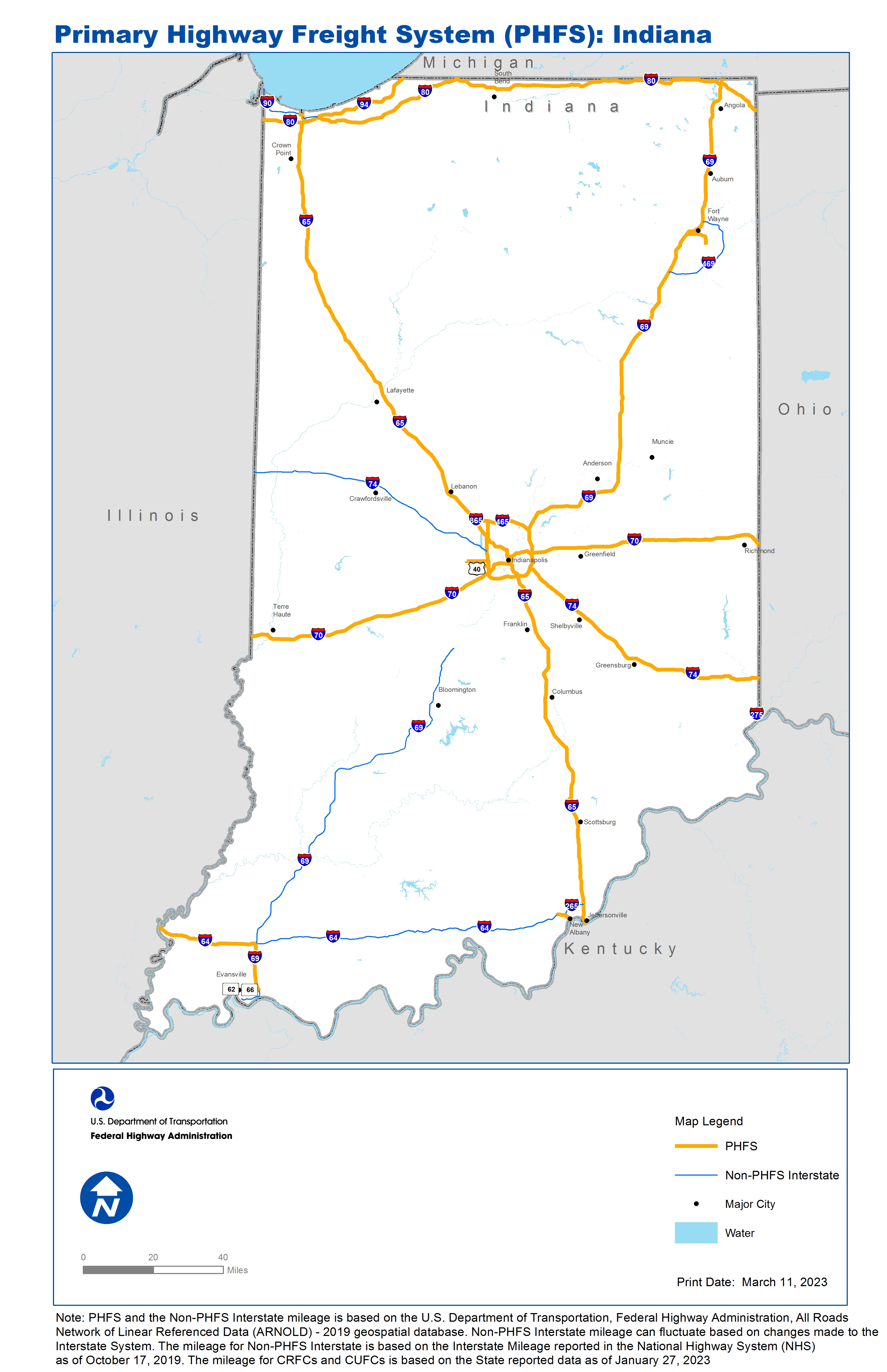
National Highway Freight Network Map and Tables for Indiana, 2022

High-Resolution Images
- JPG 2.6MB
Table of National Highway Freight Network Routes, 2022
State |
Route No/ Facility Name |
Start Point |
End Point |
Route/Facility Description |
Length (Miles) |
|---|---|---|---|---|---|
IN |
I69 |
S66 |
I64 |
I69 from S66 to I64 |
13.64 |
IN |
I465 |
I74 |
I74 |
I465 from I74 to I74 |
52.75 |
IN |
I64 |
IL/IN Line |
I69 |
I64 from IL/IN Line to I69 |
29.45 |
IN |
I64 |
U150 |
IN/KY Line |
I64 from U150 to IN/KY Line |
4.26 |
IN |
I65 |
IN14P |
IN/KY Line |
I65 from IN14P to IN/KY Line |
262.00 |
IN |
I69 |
I465 |
IN/MI Line |
I69 from I465 to IN/MI Line |
157.80 |
IN |
I70 |
IL/IN Line |
I65 |
I70 from IL/IN Line to I65 |
81.06 |
IN |
I70 |
I65 |
IN/OH Line |
I70 from I65 to IN/OH Line |
73.82 |
IN |
I74 |
I465 |
IN/OH Line |
I74 from I465 to IN/OH Line |
77.94 |
IN |
I80 |
IL/IN Line |
IN/OH Line |
I80 from IL/IN Line to IN/OH Line |
151.10 |
IN |
I865 |
I65 |
I465 |
I865 from I65 to I465 |
5.04 |
IN |
I94 |
I80 |
IN/MI Line |
I94 from I80 to IN/MI Line |
30.17 |
IN |
S62 |
IN9P |
S66 |
S62 from IN9P to S66 |
3.09 |
IN |
S66 |
S62 |
I69 |
S66 from S62 to I69 |
5.04 |
IN |
S930 |
Washington Blvd |
U30 |
S930 from Washington Blvd to U30 |
7.60 |
IN |
IN0P - Multiple ports in Ohio on Ohio River |
U50 (OH/IN Line) |
Multiple ports in Ohio on Ohio River |
From I-275: northeast on U.S 50 to Ohio State Border |
2.30 |
IN |
IN14P - U.S. Steel Port |
I65 |
U.S. Steel Port |
U12/U20 (From I65 to Virginia St) |
1.23 |
IN |
IN6R - Avon "CSX" Intermodal Facility |
I465/I74 |
Avon "CSX" Intermodal Facility |
From I-465/I-74 (exit 13): west on U.S. 36, south on Dan Jones Road to terminal |
6.60 |
IN |
IN7A - Indianapolis International Airport |
I465/I74 |
Indianapolis International Airport |
From I-465/I-74 (exit 11): west 0.3 mi on Airport Expressway to terminal entrance. From I-465/I- 74 (exit 12): west 4.1 mi on U.S. 40 to Six Points Road (CR 1050E) |
4.20 |
IN |
IN9P - Ohio River Intermodal Terminal Grouping |
S62 |
Ohio River Intermodal Terminal Grouping |
From SH 62: southwesterly 0.9 mi on Ray Becker Parkway to South Barker Avenue. From SH 62: south 0.1 mi on Wabash Avenue to port. From SH 62: south 0.1 mi on Fulton Avenue to port. |
1.00 |
PHFS Total |
|
|
|
|
970.09 |
State |
Route No/ Facility Name |
Start Point |
End Point |
Route/Facility Description |
Length (Miles) |
|---|---|---|---|---|---|
IN |
I69 |
U41 |
S66 |
I69 from U41 to S66 |
7.18 |
IN |
I265 |
I64 |
I65 |
I265 from I64 to I65 |
6.95 |
IN |
I275 |
KY/IN Line |
IN/OH Line |
I275 from KY/IN Line to IN/OH Line |
3.29 |
IN |
I469 |
I69 (South) |
I69 (North) |
I469 from I69 (South) to I69 (North) |
30.82 |
IN |
I64 |
I164 |
U150 |
I64 from I164 to U150 |
90.06 |
IN |
I74 |
IL/IN Line |
I465 (West) |
I74 from IL/IN Line to I465 (West) |
73.37 |
IN |
I90 |
IL/IN Line |
I80/I94 |
I90 from IL/IN Line to I80/I94 |
21.29 |
IN |
I69 |
I64 |
S39 |
I69 from I64 to S39 |
114.16 |
INTERSTATE NON-PHFS Total |
347.12 |
Note: PHFS and the Non-PHFS Interstate mileage is based on the U.S. Department of Transportation, Federal Highway Administration, All Roads Network of Linear Referenced Data (ARNOLD) - 2019 geospatial database. Non-PHFS Interstate mileage can fluctuate based on changes made to the Interstate System. The mileage for Non-PHFS Interstate is based on the Interstate Mileage reported in the National Highway System (NHS) as of October 17, 2019. The mileage for CRFCs and CUFCs is based on the State reported data as of January 27, 2023
Sources
U.S. Department of Transportation, Federal Highway Administration, All Roads Network of Linear Referenced Data (ARNOLD) 2019.