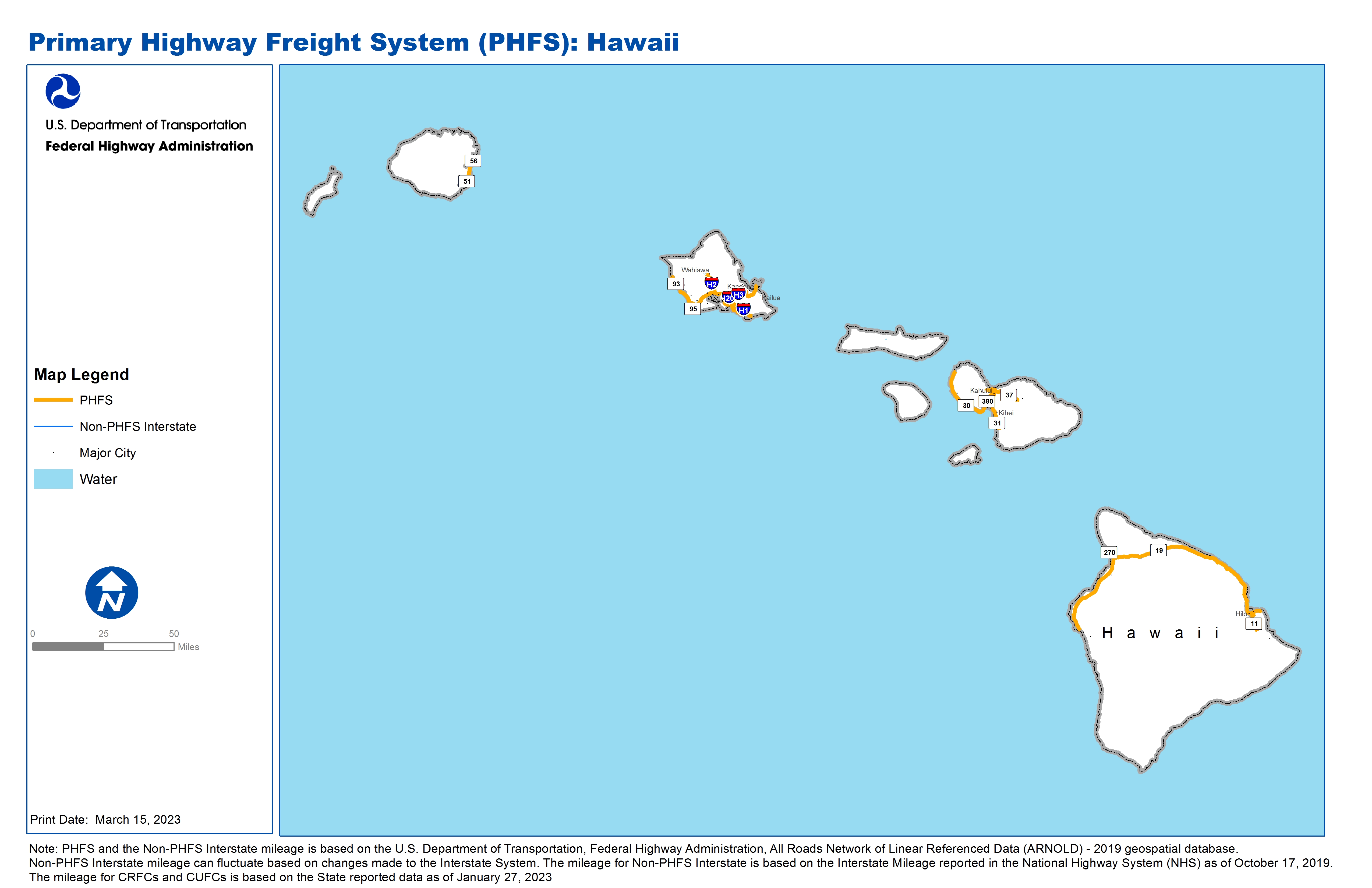
National Highway Freight Network Map and Tables for Hawaii, 2022

High-Resolution Images
- JPG 1.7MB
Table of National Highway Freight Network Routes, 2022
|
State |
Route No/ Facility Name |
Start Point |
End Point |
Route/Facility Description |
Length (Miles) |
|---|---|---|---|---|---|
HI |
IH1 |
S93 |
S72 |
IH1 from S93 to S72 |
27.15 |
HI |
IH2 |
IH1 |
S99 |
IH2 from IH1 to S99 |
8.31 |
HI |
IH201 |
IH1 |
IH1 |
IH201 from IH1 to IH1 |
4.01 |
HI |
IH3 |
IH201 |
G St |
IH3 from IH201 to G St |
14.98 |
HI |
S11 |
S19 |
6.65 South of S19 or S130 |
S11 from S19 to 6.65 South of S19 or S130 |
6.65 |
HI |
S19 |
S11 (West) |
3.92 Miles East of S11 (East) |
S19 from S11 (West) to 3.92 Miles East of S11 (East) |
101.97 |
HI |
S30 |
S380 |
24.15 Miles North of S380 |
S30 from S380 to 24.15 Miles North of S380 |
24.15 |
HI |
S31 |
S311 |
Wailea Ike Dr |
S31 from S311 to Wailea Ike Dr |
7.34 |
HI |
S311 |
S380 |
S310 |
S311 from S380 to S310 |
6.41 |
HI |
S32 |
S36 |
2.47 Miles West of S36 |
S32 from S36 to 2.47 Miles West of S36 |
2.47 |
HI |
S350 |
S380 |
S32 |
S350 from S380 to S32 |
1.12 |
HI |
S36 |
S32 |
S37 |
S36 from S32 to S37 |
2.93 |
HI |
S37 |
S36 |
S377 |
S37 from S36 to S377 |
7.53 |
HI |
S380 |
S30 |
S36 |
S380 from S30 to S36 |
6.39 |
HI |
S50 |
S56 |
1.74 Miles South of S570 |
S50 from S56 to 1.74 Miles South of S570 |
1.74 |
HI |
S51 |
S58 |
S56 |
S51 from S58 to S56 |
3.46 |
HI |
S56 |
S50 |
S570 |
S56 from S50 to S570 |
0.41 |
HI |
S56 |
S51 |
7.47 Miles North of S51 |
S56 from S51 to 7.47 Miles North of S51 |
7.47 |
HI |
S570 |
HI9A |
S56 |
S570 from HI9A to S56 |
1.13 |
HI |
S58 |
S50 |
S51 |
S58 from S50 to S51 |
2.05 |
HI |
S92 |
IH1 |
Kalakaua Ave |
S92 from IH1 to Kalakaua Ave |
6.29 |
HI |
S93 |
IH1 |
14.51 Miles North of IH1 |
S93 from IH1 to 14.51 Miles North of IH1 |
14.52 |
HI |
S99 |
IH2 |
Ka Uka Blvd |
S99 from IH2 to Ka Uka Blvd |
5.65 |
HI |
HI10P - Nawiliwili Harbor |
Nawiliwili Rd |
Nawiliwili Harbor |
Wilcox Rd, Kanoa Rd, and Waapa Rd (Nawiliwili Rd to Pier 1 and Pier 3 gates) |
0.41 |
HI |
HI12P - Barbers Point deep Draft Harbor |
Kalaeloa Blvd |
Barbers Point deep Draft Harbor |
Malakole Road and Access Road (end of NHS Route 95 to Pier 5 terminal) |
2.70 |
HI |
HI1A - Honolulu International Airport |
IH1 |
Honolulu International Airport |
H-1 Freeway on-ramp to Terminal |
2.15 |
HI |
HI2P - Honolulu Harbor |
S92 |
Honolulu Harbor |
Forrest Ave. (Ala Moana Blvd to Pier1 terminal gate) |
2.63 |
HI |
HI3A - Kahului Airport |
S36 |
Kahului Airport |
Haleakala Highway and Keolani Place (Hana Highway and terminal) |
0.91 |
HI |
HI4P - Kahului Harbor |
S36 |
Kahului Harbor |
Ala Luina Street (Hobron Ave to Pier 1 terminal) |
0.60 |
HI |
HI5A - Hilo International Airport |
S11 |
Hilo International Airport |
Kekuanaoa St (Kanoelehua Ave to terminal) |
1.18 |
HI |
HI6P - Hilo Harbor |
S19 |
Hilo Harbor |
Driveway (Kuhio Street/Harbor Gate to Pier 1 terminal) |
0.19 |
HI |
HI7P - Kawaihae Harbor |
S270 |
Kawaihae Harbor |
Access Road (Kawaihae Rd to Pier 1 and Pier 2 terminals) |
2.65 |
HI |
HI8A - Keahole International Airport |
S19 |
Keahole International Airport |
Airport Access Rd (Queen Kaahumanu Highway to Terminal) |
0.64 |
HI |
HI9A - Lihue Airport |
S570 |
Lihue Airport |
Ahukini Road (End of S570 to terminal) |
0.59 |
PHFS Total |
|
|
|
|
278.79 |
|
State |
Route No/ Facility Name |
Start Point |
End Point |
Route/Facility Description |
Length (Miles) |
|---|---|---|---|---|---|
INTERSTATE NON-PHFS Total |
|
|
|
|
0 |
Note: PHFS and the Non-PHFS Interstate mileage is based on the U.S. Department of Transportation, Federal Highway Administration, All Roads Network of Linear Referenced Data (ARNOLD) - 2019 geospatial database. Non-PHFS Interstate mileage can fluctuate based on changes made to the Interstate System. The mileage for Non-PHFS Interstate is based on the Interstate Mileage reported in the National Highway System (NHS) as of October 17, 2019. The mileage for CRFCs and CUFCs is based on the State reported data as of January 27, 2023
Sources
U.S. Department of Transportation, Federal Highway Administration, All Roads Network of Linear Referenced Data (ARNOLD) 2019.