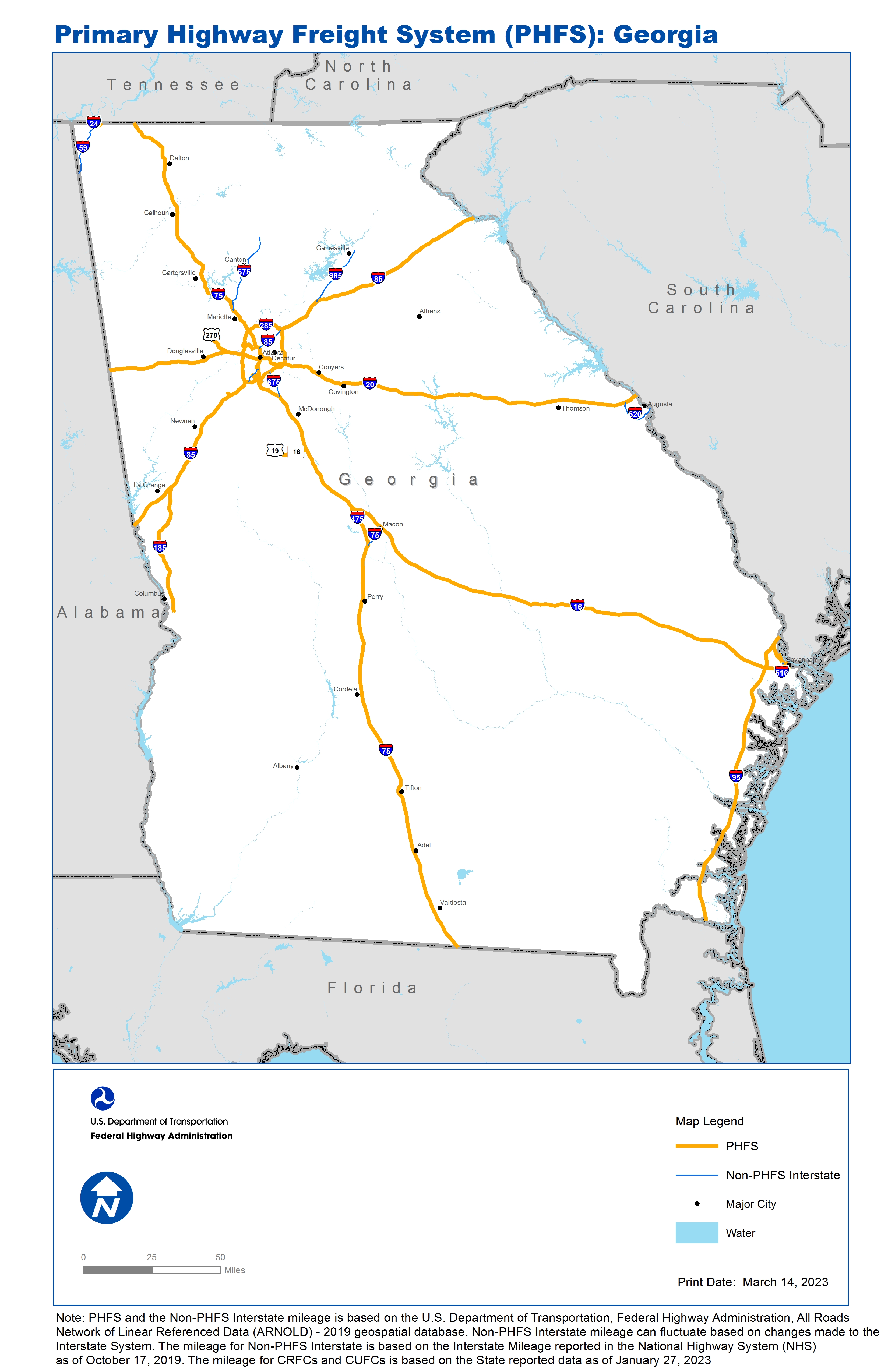
National Highway Freight Network Map and Tables for Georgia, 2022

High-Resolution Images
- JPG 2.9MB
Table of National Highway Freight Network Routes, 2022
|
State |
Route No/ Facility Name |
Start Point |
End Point |
Route/Facility Description |
Length (Miles) |
|---|---|---|---|---|---|
GA |
I16 |
I75 |
2.28 Miles East of I516 |
I16 from I75 to 2.28 Miles East of I516 |
165.40 |
GA |
I185 |
I85 |
U280 |
I185 from I85 to U280 |
49.67 |
GA |
I20 |
AL/GA Line |
GA/SC Line |
I20 from AL/GA Line to GA/SC Line |
201.57 |
GA |
I24 |
TN/GA Line |
GA/TN Line |
I24 from TN/GA Line to GA/TN Line |
4.10 |
GA |
I285 |
I85 |
I85 |
I285 from I85 to I85 |
63.26 |
GA |
I475 |
I75 |
I75 |
I475 from I75 to I75 |
15.93 |
GA |
I516 |
GA26R |
GA25P |
I516 from GA26R to GA25P |
2.05 |
GA |
I75 |
FL/GA Line |
I475 |
I75 from FL/GA Line to I475 |
156.22 |
GA |
I75 |
I16 |
GA/TN Line |
I75 from I16 to GA/TN Line |
189.87 |
GA |
I85 |
AL/GA Line |
I285 |
I85 from AL/GA Line to I285 |
69.51 |
GA |
I85 |
I285 |
GA/SC Line |
I85 from I285 to GA/SC Line |
83.76 |
GA |
I95 |
FL/GA Line |
GA/SC Line |
I95 from FL/GA Line to GA/SC Line |
111.82 |
GA |
S166 |
GA5R |
I75 |
S166 from GA5R to I75 |
0.80 |
GA |
S21 |
GA24P |
I95 |
S21 from GA24P to I95 |
5.56 |
GA |
S6 |
I20 |
U278 |
S6 from I20 to U278 |
2.64 |
GA |
U19 |
GA60R |
GA28L |
U19 from GA60R to GA28L |
1.96 |
GA |
U278 |
S6 |
6.54 Miles North of S6 |
U278 from S6 to 6.54 Miles North of S6 |
6.54 |
GA |
GA24P - Garden City Terminal, Savannah |
S21 |
Garden City Terminal, Savannah |
From SR25/SR21 northwesterly on SR 25, westerly on SR307 (Bourne Ave) to SR21/SR17. . |
4.52 |
GA |
GA25P - Savannah Ocean Terminal |
I516 |
Savannah Ocean Terminal |
From W Lathrop Ave (CR 1142); SE on Lathrop Ave (CR 740), continue on River St (Savannah City St 145) to the terminal |
1.38 |
GA |
GA26R - CSX Railyard, Savannah |
I516 |
CSX Railyard, Savannah |
From I-516: N&W 0.70 mi on Tremont Rd, N 0.1 mi on Tremont Ave, W 0.2 mi on Safety First Rd. . |
0.97 |
GA |
GA28L - Colonial Pipeline, Griffin |
U19 |
Colonial Pipeline, Griffin |
From SR3/US19: E 0.4 mi on East McIntosh Rd, N 0.4 mi on Old Atlanta Rd, E 1.3 mi on McIntosh Rd. |
2.15 |
GA |
GA2A - Atlanta Hartsfield International Airport |
I85 |
Atlanta Hartsfield International Airport |
I-85 exit 18-A, NE 1.25 mi on Cr 2045; and 0.41 mi on CS 800111 to the N Cargo Building. I-75 exit 82, W 0.07 mi to Aviation blvd (CR 1516), N 0.7 mi on CR 1568 and 0.68 mi on CS 800111 to N Cargo Building. I-75 exit 83, 0.41 mi on CR 2206 and 1.21 mi |
5.13 |
GA |
GA32R - Fairfax CSX Industry Yard, Fairburn |
I85 |
Fairfax CSX Industry Yard, Fairburn |
From I-85, NW 1.12 mi on SR-74;10 mi on CS 406809, and SW 1.24 on CR-633 (McLarin Rd) to the Fairburn CSX Industry Yard |
1.77 |
GA |
GA33P - Port of Savannah |
S21 |
Port of Savannah |
From SR21 northeasterly on Grange Road to termina facilities |
1.04 |
GA |
GA3R - Atlanta Hulsey Rail Yard |
I20 |
Atlanta Hulsey Rail Yard |
From I-20(ex 26): north 0.5 miles on Boulevard to the entrance of the truck/rail facility |
0.54 |
GA |
GA4R - Atlanta Inman Rail Yard |
I285 |
Atlanta Inman Rail Yard |
From I-285: S 1.3 mi on S. Cobb Dr. and SR 280, NE 1.0 mi on Bolton Rd, SE 2.3 mi on Marietta Rd. |
5.05 |
GA |
GA54R - Norfolk-Southern Rail Forest Park |
I75 |
Norfolk-Southern Rail Forest Park |
From I-75 take the Forest Pky., exit to the Rail Yard at Kennedy Rd |
1.81 |
GA |
GA55R - Norfolk-Southern Whitaker Intermodal Facility |
I20 |
Norfolk-Southern Whitaker Intermodal Facility |
From I-20 take the North Thornton Rd. (SR-6) exit to Westside Dr. (SR-6 Spur) to the entrance to the rail yard |
0.45 |
GA |
GA58R - Howells CSX Rail Yard |
I75 |
Howells CSX Rail Yard |
From I-75 exit 252B take the Howell Mill Rd. to the CSX Rail Yard at Chattahoochee Ave |
0.85 |
GA |
GA5R - Norfolk-Southern Industry Yard, East Point |
S166 |
Norfolk-Southern Industry Yard, East Point |
From Lakewood Freeway (SR 166), S 0.1 mi on Sylvan Rd (CS 235303), and W 0.34 mi on Lakewood Ave (CS 126303) to the terminal gates |
0.37 |
GA |
GA60R - Griffin Norfolk Southern Yard |
U19 |
Griffin Norfolk Southern Yard |
From SR-3/U.S. 19 and 41 in Spalding Co. east on SR-16 to Griffin CS-069605 to the railyard, then along SR-16 to I-75 exit 205 in Butts Co |
12.65 |
GA |
GA6L - Chattahoochee Colonial Pipeline, Atlanta |
S280 |
Chattahoochee Colonial Pipeline, Atlanta |
From S. Cobb Dr. and SR 280: S 0.9 mi on Bolton Rd, N 0.2 mi on Parrot Avenue |
1.21 |
GA |
GA7L - Doraville Colonial & Plantation Pipeline |
I285 |
Doraville Colonial & Plantation Pipeline |
From I-285, Exit 25 N on Buford Highway (SR 13) 0.3 mi to Longmire Way, left 0.2 mi to Winters Chapel/Flowers Rd, left and right to rail, truck, and pipeline gates |
1.01 |
PHFS Total |
|
|
|
|
1171.56 |
|
State |
Route No/ Facility Name |
Start Point |
End Point |
Route/Facility Description |
Length (Miles) |
|---|---|---|---|---|---|
GA |
I516 |
U80 |
W Lathrop Ave |
I516 from U80 to W Lathrop Ave |
4.92 |
GA |
I520 |
I20 |
S28 |
I520 from I20 to S28 |
15.40 |
GA |
I575 |
I75 |
S5 |
I575 from I75 to S5 |
31.03 |
GA |
I59 |
AL/GA Line |
I24 |
I59 from AL/GA Line to I24 |
20.12 |
GA |
I675 |
I75 |
I285 |
I675 from I75 to I285 |
10.20 |
GA |
I75 |
I475 |
I16 |
I75 from I475 to I16 |
8.67 |
GA |
I85 |
I75 |
I285 (North) |
I85 from I75 to I285 (North) |
10.51 |
GA |
I85 |
I285 (South) |
I75 |
I85 from I285 (South) to I75 |
6.42 |
GA |
I985 |
I85 |
U23 |
I985 from I85 to U23 |
24.00 |
INTERSTATE NON-PHFS Total |
|
|
|
|
131.27 |
Note: PHFS and the Non-PHFS Interstate mileage is based on the U.S. Department of Transportation, Federal Highway Administration, All Roads Network of Linear Referenced Data (ARNOLD) - 2019 geospatial database. Non-PHFS Interstate mileage can fluctuate based on changes made to the Interstate System. The mileage for Non-PHFS Interstate is based on the Interstate Mileage reported in the National Highway System (NHS) as of October 17, 2019. The mileage for CRFCs and CUFCs is based on the State reported data as of January 27, 2023
Sources
U.S. Department of Transportation, Federal Highway Administration, All Roads Network of Linear Referenced Data (ARNOLD) 2019.