National Highway Freight Network Map and Tables for Florida, 2022

High-Resolution Images
- JPG 2.6MB
Table of National Highway Freight Network Routes, 2022
|
State |
Route No/ Facility Name |
Start Point |
End Point |
Route/Facility Description |
Length (Miles) |
|---|---|---|---|---|---|
FL |
I10 |
AL/FL Line |
I95 |
I10 from AL/FL Line to I95 |
362.14 |
FL |
I110 |
FL2P |
I10 |
I110 from FL2P to I10 |
6.17 |
FL |
I275 |
FL7P |
I75 |
I275 from FL7P to I75 |
1.65 |
FL |
I275 |
I75 |
2.44 Miles South of S694 |
I275 from I75 to 2.44 Miles South of S694 |
34.52 |
FL |
I295 |
I95 |
I95 |
I295 from I95 to I95 |
60.34 |
FL |
I395 |
FL48A |
I95 |
I395 from FL48A to I95 |
1.18 |
FL |
I4 |
I275 |
I95 |
I4 from I275 to I95 |
131.97 |
FL |
I595 |
I75 |
U1 |
I595 from I75 to U1 |
13.77 |
FL |
I75 |
S821 |
GA/FL Line |
I75 from S821 to GA/FL Line |
465.89 |
FL |
I95 |
U41 |
FL/GA Line |
I95 from U41 to FL/GA Line |
380.46 |
FL |
S408 |
I4 |
S436 |
S408 from I4 to S436 |
4.45 |
FL |
S417 |
FL12A |
S91 |
S417 from FL12A to S91 |
5.15 |
FL |
S528 |
I4 |
8.40 Miles East of I4 |
S528 from I4 to 8.40 Miles East of I4 |
8.41 |
FL |
S528 |
FL15P |
I95 |
S528 from FL15P to I95 |
12.46 |
FL |
S821 |
U27 |
I75 |
S821 from U27 to I75 |
4.07 |
FL |
S826 |
S976 |
S91 |
S826 from S976 to S91 |
20.56 |
FL |
S836 |
S826 |
I95 |
S836 from S826 to I95 |
7.58 |
FL |
S91 |
I75 |
1.66 Miles South of S417 |
S91 from I75 to 1.66 Miles South of S417 |
59.34 |
FL |
S91 |
S826 |
I95 |
S91 from S826 to I95 |
0.30 |
FL |
U1 |
I395 |
FL18P |
U1 from I395 to FL18P |
0.46 |
FL |
U27 |
S826 |
S112 |
U27 from S826 to S112 |
5.01 |
FL |
FL11R - CSX Intermodal - Orlando |
S528 |
CSX Intermodal - Orlando |
Atlantic Ave--Landstreet Rd--Boggy Creek Rd--E and W ramps to SR 528--Jetport Dr ramp (CSX entrance on Atlantic Ave to SR 528) |
2.15 |
FL |
FL12A - Orlando International Airport |
S417 |
Orlando International Airport |
Boggy Creek Rd (Entrance to SR 417) |
1.01 |
FL |
FL15P - Port Canaveral |
S528 |
Port Canaveral |
George King Bl (Port to A1A), Dave Nisbet Dr (George King to SR 528), SR 528 (Dave N. to SR 401) |
0.91 |
FL |
FL17A - Miami International Airport |
S836 |
Miami International Airport |
NW 37th Ave, NW 21st S St, NW 42nd St Ave, LeJeune Rd: from (south ramp of SR 836@NW 37th and south ramp of SR 836@NW 42nd) to (Entrance at NW 42nd Ave and 21st St). NW 25th St: from SR 826 to terminal entrance at NW 68th Ave |
2.13 |
FL |
FL18P - Port of Miami |
I395 |
Port of Miami |
Along 1st Ave--2nd Ave--NE 6th St--NE 5th St-- Port Blvd: (Port entrance to I-395 and I-95) |
3.01 |
FL |
FL19R - Parsec Miami/Parsec Automobile Terminal |
S826 |
Parsec Miami/Parsec Automobile Terminal |
NW 36 St (NW67 to SR826), NW 67th Av. (SR948 to NW25), NW 25th (SR826 to NW67) |
2.81 |
FL |
FL20R – Parsec (North) - Miami |
S826 |
Parsec (North) - Miami |
Hialeah Expressway/SR 934, NW 72nd St, NW 74th St, NW 69th Ave: from both SR 826 and Okeechobee Rd to port entrance |
0.87 |
FL |
FL25R - Parsec Florida East Coast Railroad -Jacksonville |
I95 |
Parsec Florida East Coast Railroad -Jacksonville |
University Blvd/SR109, Phillips Hwy/US1, J Turner Butler Blvd/SR202: from (I-95@Unversity Blvd and I-95@J. Turner Butler Blvd) to Parsec entrance |
2.80 |
FL |
FL27R - Norfolk Southern Yards - Jacksonville |
I10 |
Norfolk Southern Yards - Jacksonville |
SR 111/Cassat Ave, Edgewood Ave, Edgewood Dr: from I-10 to Yard property |
3.81 |
FL |
FL28P - Jacksonville Port Authority |
I95 |
Jacksonville Port Authority |
20th St Expressway, Phoenix Ave, 21st St, N Talleyrand Ave: from I-95 to north entrance. US ALT 1, 8th St, S Talleyrand Ave: from junction of 20th St Expressway/US ALT 1 to south entrance. . |
4.62 |
FL |
FL2P - Pensacola Seaport |
I110 |
Pensacola Seaport |
Along Chase St--Bayfront Pkwy--Barracks St--9th Ave (from I-110/Chase St to port; from port to I- 110/Gregory St) |
1.80 |
FL |
FL31R - CSXT Bulk Intermodal Facility |
I295 |
CSXT Bulk Intermodal Facility |
Pritchard Rd, Sportsman Club Rd: from I-295 to CSX entrance |
0.99 |
FL |
FL33P - Port of Tampa |
I4 |
Port of Tampa |
Maritime Blvd, 22nd St, N 21 St: from I-4 ramps to Port entrance at Pier 219 |
3.33 |
FL |
FL39A - Ft. Lauderdale International Airport |
FL5P |
Ft. Lauderdale International Airport |
SW 4th Ave (Perimeter Rd/Cargo area to SR84/SW 24th St) |
0.77 |
FL |
FL42R - Parsec - West Palm Beach |
I95 |
Parsec - West Palm Beach |
Palm Beach Lakes Blvd/CR716, US 1, 15th St: from I-95 ramp to Parsec at Henrietta Ave |
2.85 |
FL |
FL46P - Port of Fort Pierce |
I95 |
Port of Fort Pierce |
SR 70, US 1: from I-95 east ramps to Port entrance |
6.07 |
FL |
FL48A - Watson Island Intl. Sea Plane Airport |
I395 |
Watson Island Intl. Sea Plane Airport |
MacArthur Causeway (Sea Plane Base to I-395) |
1.06 |
FL |
FL52R - Uceta Intermodal Yard CSX Facility |
I4 |
Uceta Intermodal Yard CSX Facility |
US41/N 50th St, Broadway/CR574, 62 St: from (I- 4 ramp #84) to (8th Ave at Yard entrance) |
2.68 |
FL |
FL5P - Port Everglades - Fort Lauderdale |
I95 |
Port Everglades - Fort Lauderdale |
SR 84 (from I-95 to north port entrance at Slip Head Rd). branching from 1st connector: from SR 84/S Andrews Ave southerly along NE 7th Ave and Eller Dr to southern port entrance |
3.93 |
FL |
FL6P - Port of Palm Beach |
I95 |
Port of Palm Beach |
Along SR 708--SR 710---45th St Exit--Congress Ave (From I-95 ramps and SR 708/SR 710 along Congress Ave and SR 710 to port entrance) |
6.17 |
FL |
FL7P - Port Manatee |
I275 |
Port Manatee |
Piney Point Rd. (Dock St. to US 41), US 41 (Piney Point to I-275) |
4.54 |
FL |
FL8A - S.W. Florida Intl. Airport - Ft Myers |
I75 |
S.W. Florida Intl. Airport - Ft Myers |
Daniels Rd. (I-75 to airport entrance) |
0.52 |
PHFS Total |
|
|
|
|
1,644.71 |
|
State |
Route No/ Facility Name |
Start Point |
End Point |
Route/Facility Description |
Length (Miles) |
|---|---|---|---|---|---|
FL |
I175 |
I275 |
1.30 Miles East of I275 |
I175 from I275 to 1.30 Miles East of I275 |
1.30 |
FL |
I195 |
I95 |
4.40 Miles East of I95 |
I195 from I95 to 4.40 Miles East of I95 |
4.41 |
FL |
I275 |
U41 |
2.44 Miles South of S694 |
I275 from U41 to 2.44 Miles South of S694 |
22.90 |
FL |
I375 |
I275 |
1.11 Miles East of I275 |
I375 from I275 to 1.11 Miles East of I275 |
1.11 |
FL |
I75 |
S924 |
S821 |
I75 from S924 to S821 |
4.92 |
FL |
I95 |
U1 |
S90 |
I95 from U1 to S90 |
1.55 |
INTERSTATE NON-PHFS Total |
|
|
|
|
36.19 |
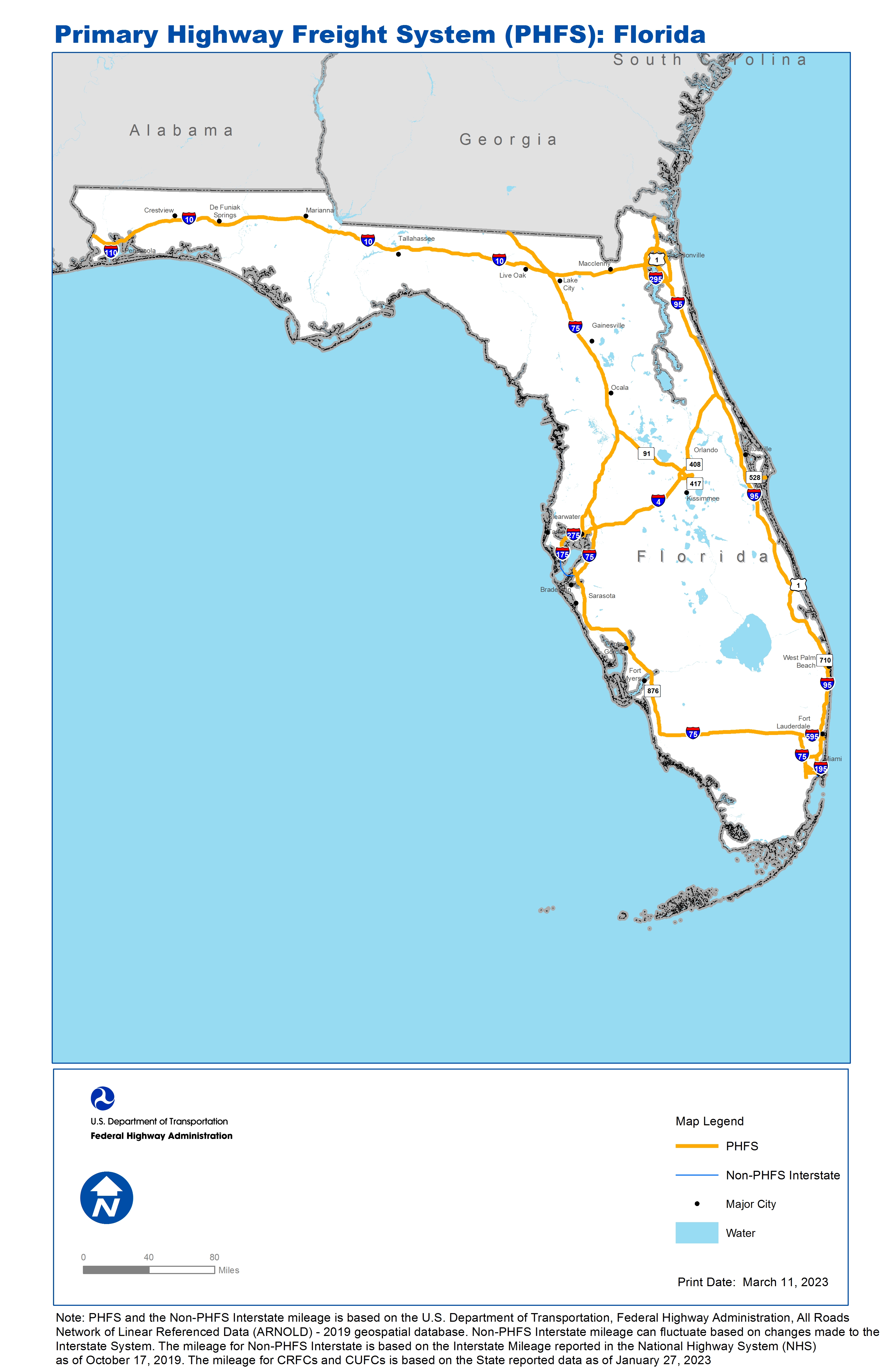
Note: PHFS and the Non-PHFS Interstate mileage is based on the U.S. Department of Transportation, Federal Highway Administration, All Roads Network of Linear Referenced Data (ARNOLD) - 2019 geospatial database. Non-PHFS Interstate mileage can fluctuate based on changes made to the Interstate System. The mileage for Non-PHFS Interstate is based on the Interstate Mileage reported in the National Highway System (NHS) as of October 17, 2019. The mileage for CRFCs and CUFCs is based on the State reported data as of January 27, 2023
Sources
U.S. Department of Transportation, Federal Highway Administration, All Roads Network of Linear Referenced Data (ARNOLD) 2019.