National Highway Freight Network Map and Tables for Colorado, 2022

High-Resolution Images
- JPG 2.1MB
Table of National Highway Freight Network Routes, 2022
|
State |
Route No/ Facility Name |
Start Point |
End Point |
Route/Facility Description |
Length (Miles) |
|---|---|---|---|---|---|
CO |
I225 |
I25 |
I70 |
I225 from I25 to I70 |
12.47 |
CO |
I25 |
NM/CO Line |
CO/WY Line |
I25 from NM/CO Line to CO/WY Line |
298.69 |
CO |
I270 |
I76 |
I70 |
I270 from I76 to I70 |
4.92 |
CO |
I70 |
UT/CO Line |
CO/KS Line |
I70 from UT/CO Line to CO/KS Line |
450.29 |
CO |
I76 |
I70 |
U85 |
I76 from I70 to U85 |
12.57 |
CO |
S2 |
CO12R |
I70 |
S2 from CO12R to I70 |
0.49 |
CO |
S470 |
CO22A |
I70 |
S470 from CO22A to I70 |
7.42 |
CO |
U6 |
CO11L |
I270 |
U6 from CO11L to I270 |
0.24 |
CO |
U85 |
I25 |
2.04 Miles South of I25 |
U85 from I25 to 2.04 Miles South of I25 |
2.04 |
CO |
CO10R - Burlington Northern RR Transfer Facility |
I25 |
Burlington Northern RR Transfer Facility |
53rd Pl. to Broadway to 58th Ave (S.H. 53) to I- 25 |
1.02 |
CO |
CO11L - Conoco Pipeline Transfer |
U6 |
Conoco Pipeline Transfer |
From U.S. 6: W 0.8 mi on 56th Avenue to Terminal Entrance at Brighton Blvd (S.H. 265) |
0.82 |
CO |
CO12R - Union Pacific RR Transfer Facility |
S2 |
Union Pacific RR Transfer Facility |
From S.H. 2 (Colorado Blvd): W 1.4 mi on 40th Ave to terminal entrance at Williams Street |
1.49 |
CO |
CO22A - Denver International Airport |
S470 |
Denver International Airport |
Pena Blvd (E 470 interchange E 0.7mi) |
4.38 |
CO |
CO6R - Union Pacific RR Auto Transfer |
I76 |
Union Pacific RR Auto Transfer |
From I-76: E 0.1 mi on 96th Ave, N 1.0 mi on I-76 Frontage Road to Terminal Entrance |
0.51 |
CO |
CO7R - Burlington Northern RR Auto Transfer |
I76 |
Burlington Northern RR Auto Transfer |
From I-76: E 1.7 mi on 88th Ave, N 0.2 mi on Yosemite Ave to terminal entrance |
1.64 |
CO |
CO8L - Kaneb Pipeline Transfer |
I76 |
Kaneb Pipeline Transfer |
From I-76: E 0.1 mi on 88th Ave, S 1.2 mi on Brighton Rd, E 0.3 mi on 80th St to entrance at Krameria St. |
1.52 |
CO |
CO9R - Southern Pacific RR Transfer Facility |
I76 |
Southern Pacific RR Transfer Facility |
From I-76: South on Pecos Street to Terminal Entrance at 56th Avenue |
1.22 |
PHFS Total |
|
|
|
|
801.72 |
|
State |
Route No/ Facility Name |
Start Point |
End Point |
Route/Facility Description |
Length (Miles) |
|---|---|---|---|---|---|
CO |
I270 |
I25 |
I76 |
I270 from I25 to I76 |
0.96 |
CO |
I76 |
U85 |
CO/NE Line |
I76 from U85 to CO/NE Line |
171.54 |
INTERSTATE NON-PHFS Total |
|
|
|
|
172.50 |
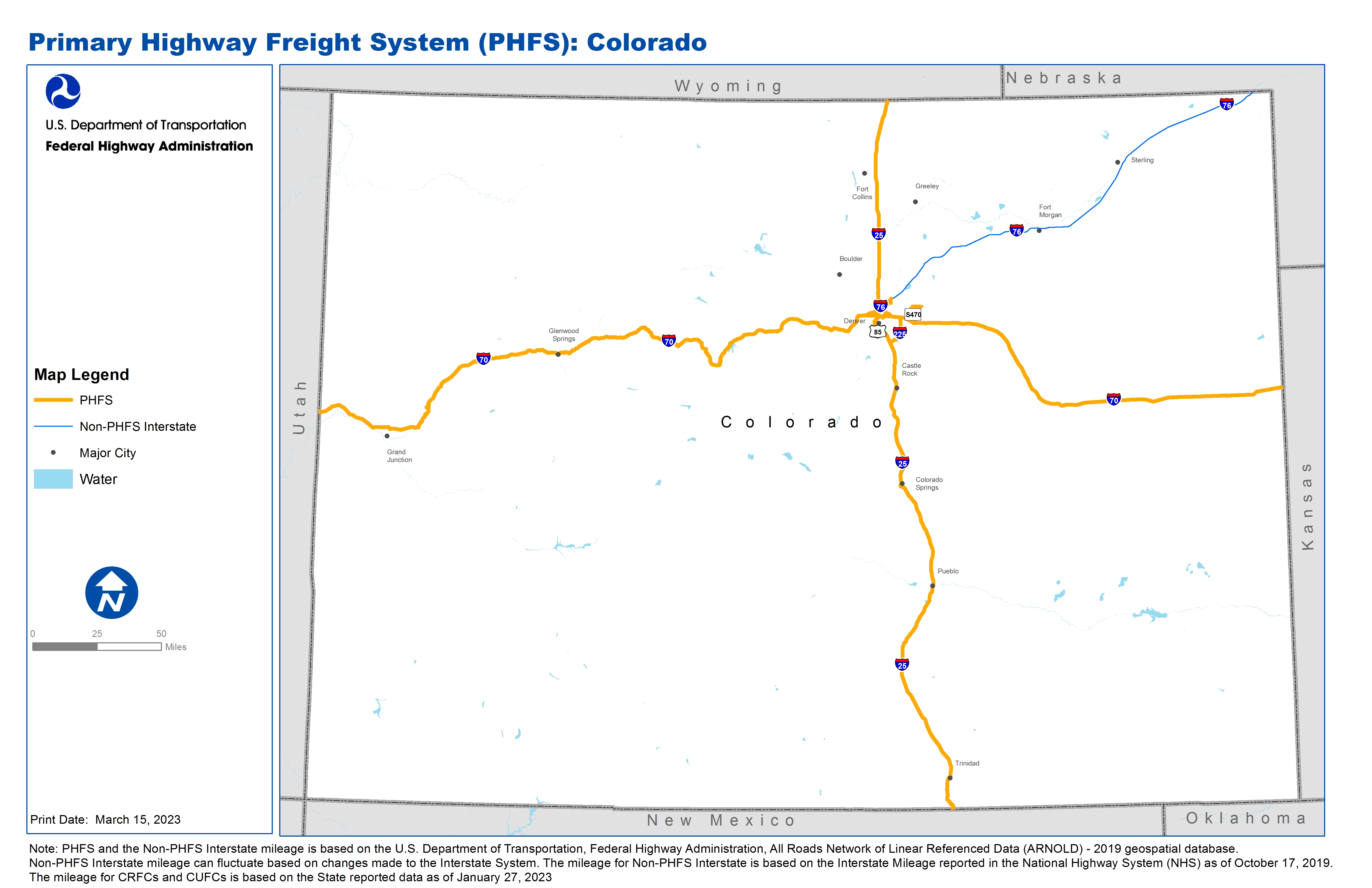
Note: PHFS and the Non-PHFS Interstate mileage is based on the U.S. Department of Transportation, Federal Highway Administration, All Roads Network of Linear Referenced Data (ARNOLD) - 2019 geospatial database. Non-PHFS Interstate mileage can fluctuate based on changes made to the Interstate System. The mileage for Non-PHFS Interstate is based on the Interstate Mileage reported in the National Highway System (NHS) as of October 17, 2019. The mileage for CRFCs and CUFCs is based on the State reported data as of January 27, 2023
Sources
U.S. Department of Transportation, Federal Highway Administration, All Roads Network of Linear Referenced Data (ARNOLD) 2019.