Major Freight Corridors
The largest freight flows are concentrated on a relatively small number of corridors. Figure 8 highlights segments of the freight transportation network that carry more than 50 million tons per year, including:
- Highway segments that carry at least 8,500 trucks per day, which is the number needed to move 50 million tons per year at 16 tons per truck.
- Additional highway segments and parallel rail lines that together carry at least 8,500 truck, trailer-on-flatcar, and container-on-flatcar payloads of typically high-value, time-sensitive cargo at 16 tons per payload.
- Rail lines and waterways that carry 50 million tons in bulk cargo per year.
Figure 8. Components of Major Freight Corridors
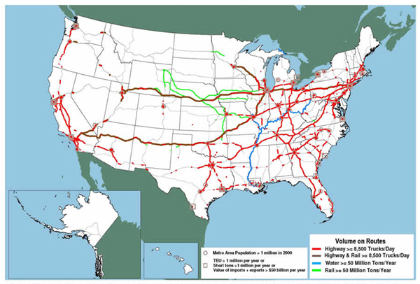
Source: U.S. Department of Transportation, Federal Highway Administration, Office of Freight Management and Operations, 2008.
Figure 9 shows major freight corridors by connecting gaps less than 440 miles (the distance a truck can travel in 8 hours at 55 miles per hour) between highway segments displayed in Figure 8 and adding routes that parallel bulk cargo rail lines and waterways. The corridors in Figure 9 include approximately 26,000 miles of highways plus an additional 1,500 miles of bulk cargo rail and waterway routes measured along the nearest parallel highway. Interstate highways account for over 95 percent of the total 27,500 miles. The total mileage is about 60 percent of the length of the Interstate System and less than 17 percent of the National Network designated for conventional combination trucks.
Figure 9. Major Freight Corridors
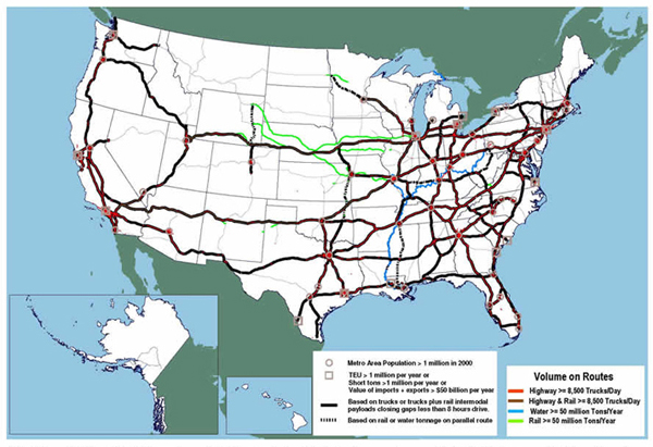
Source: U.S. Department of Transportation, Federal Highway Administration, Office of Freight Management and Operations, 2008.
|
The National Network The National Network was authorized by the Surface Transportation Assistance Act of 1982 (P.L. 97-424) and specified in the U.S. Code of Federal Regulations (23 CFR 658) to require states to allow conventional combinations on "the Interstate System and those portions of the Federal-aid Primary System ... serving to link principal cities and densely developed portions of the States ... [on] high volume route[s] utilized extensively by large vehicles for interstate commerce ... [which do] not have any unusual characteristics causing current or anticipated safety problems." Conventional combinations are tractors with one semitrailer up to 48 feet in length or with one 28-foot semitrailer and one 28-foot trailer, and can be up to 102 inches wide. The National Network differs in extent and purpose from the National Highway System (NHS), which was created more than a decade later by the National Highway System Designation Act of 1995 (P.L. 104-59). Both are about the same length, roughly 200,000 miles, but the National Network includes approximately 65,000 miles of highways beyond the NHS, and the NHS includes about 50,000 miles of highways that are not on the National Network. The National Network supports interstate commerce by regulating the size of trucks, while the NHS supports interstate commerce by focusing federal investments. The National Network has not changed significantly in a quarter century. It is modified only if segments are added to the Interstate highway system or if states petition to have a segment beyond the Interstate highway system added or deleted. Petitions for modifications have not been received in years, even though the geography of interstate commerce has changed significantly with the growth of smaller communities into principal cities and the emergence of new, densely developed areas. Consistency between the National Network and freight-related portions of the more recent NHS is not required. The definition of conventional combinations is also unchanged, even though 48-feet is no longer the maximum length of a single trailer in the majority of states. Single 53-foot trailers are allowed in 25 states without special permits and in an additional 3 states subject to limits on distance of kingpin to rearmost axle. |
![]() You will need the Adobe Acrobat Reader to view the PDFs on this page.
You will need the Adobe Acrobat Reader to view the PDFs on this page.