5.0 Rural Low AADT
5.1 Beartooth Highway
 Key Observations
- CFLHD used QuickZone's capabilities to help inform the local community of possible future delays through a series of concurrent flagging operations.
- CFLHD was able to see that no one flagging operation would cause major delay problems but the combination of all four did produce potentially unacceptable delay.
- CFLHD was able to quickly evaluate a series of work zones and their interactions with each other without having to use more complex simulation models.
5.1.1 Overview
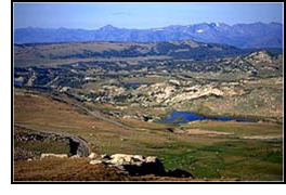
Beartooth highway, or US-212, begins in the northeast entrance of Yellowstone Park and continues along the Montana-Wyoming state border. This 64 mile highway is known for its spectacular views of many different ecosystems including lush forest and alpine tundra. The Beartooth Mountains, for which the highway is named, boast one of the highest elevations and most rugged regions in the county.
In addition to the traditional use for automobile travel, the highway is also used for cross-country skiing, hiking to view the wildlife and views, guided horseback riding tours, and snowmobiling in the off season when the road is closed to automobiles. Other attractions for the highway include fishing in the adjacent steams and lakes, and camping in the twelve National Forest campgrounds located along the highway. Beartooth Highway is unique compared to the other case studies in that the road itself is the destination rather than the road leading a destination or point of interest.
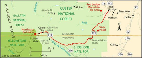
Figure 5.1.1 Beartooth Highway Location
FHWA CFLHD has been working with the US Forest Service and the Yellowstone Park Service to reconstruct an 18.6 mile section of the Beartooth Highway. This section has not been rebuilt since the original construction in 1936. The highway can no longer support the types of vehicles driving on it today nor the increased volumes anticipated in future years. The reconstruction project will consist of upgrading the current roadway with improvements to the alignment, grade, and width of the road to meet current FHWA guidelines. The two following pictures show the extent of the construction with the left hand picture showing the current condition of the highway and right hand picture showing the new proposed construction.
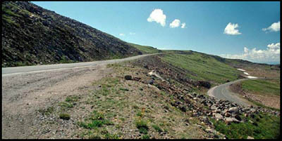
Current Highway

Proposed Highway
The construction season for the Beartooth Highway is very limited because the highway is closed from October – March each year due to heavy snowfall. CFLHD is concerned that this type of construction, on this generally peaceful 2-lane highway, would cause major delays for the local public and vacationers so they decided to use the FHWA's QuickZone software.
The QuickZone software was used to evaluate a series of four different flagging operations near the Beartooth Ravine which is part of the proposed 18.6 mile section. QuickZone allowed CFLHD to account for delays on each work zone and also delays incurred by all work zones in conjunction with each other. QuickZone could also handle the detailed seasonality demand information. Some of the key information CFLHD was seeking to gather from the QuickZone Software was the delay during under saturated and saturated conditions and queue information for all of the work zones.
5.1.2 Network Design
The network for the Beartooth project was designed using the QuickZone network editor. A copy of the whole 18.6 mile construction layout was scanned in from the environmental impact statement created for the Beartooth Project and was imposed into the QuickZone network editor. With the construction layout in the QuickZone network editor, software nodes and links were quickly added to create the new QuickZone network.
The design of the Beartooth network is very simplistic with no exits, detours, or complex intersections. All of the 18.6 mile highway section was created for QuickZone with work zone links added only around the section that contained the Beartooth Ravine. This allowed for future QuickZone studies to be conducted along the section without having to recreate a network. Below is a close up picture showing the Beartooth Ravine section of the QuickZone Network:
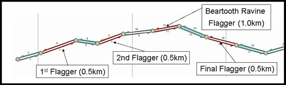
Figure 5.1.2 Beartooth Highway QuickZone Network
Each of the four flagging operations were added as work zones with 1 kilometer distances between each work zone which was based on the project engineer estimates. All flagging operations were 0.5 kilometers in length except for the Beartooth Ravine flagging operation that had a length of 1.0 kilometer.
5.1.3 Results
The first results returned from QuickZone for the four flagging operations produced substantial amounts of saturated delay caused by the switchover time of the flagging operations. A switchover time of 5 minutes was used to start, based on more urban flagging operations. Upon further investigation of the project it was determined that CFLHD can have switchover times as high as 15 minutes because of the low volumes and long flagging operations. With this new higher switchover value we found that the four work zones only produced unsaturated delay from the flagging operations. Using QuickZone's fast calculation time a trial and error method was used to determine the optimal switchover time for the flagging operations that would not produce any saturated delay and a value of 7 minutes was found.
Using a switchover time of 7 minutes and the same speed throughout all of the work zones, QuickZone produced identical results for all work zones except the Beartooth Ravine flagging operation. These results are the same because the demand, switchover time, speed, and work zone length are the same for all 3 work zones. However, the values on the Beartooth Ravine were higher which was caused by the longer work zone length. Below are the values produced for each of the work zones.
| Work Zone | Delay (Minutes): Max User | Delay (Minutes): Average User | Queue (Vehicles): Max | Queue (Vehicles): Average |
|---|---|---|---|---|
| 1st, 2nd, and Final | 3.0 | 2.8 | 3 | 1.4 |
| Beartooth Ravine | 5.7 | 5.3 | 6 | 2.3 |
Each work zone produces marginal delays but by combining all the work zones together we get a maximum user delay of 14.7 minutes and 15 vehicles in queue in the inbound and outbound directions. This maximum delay occurs on Sunday between the hours of 1:00PM – 2:00PM during July which matches up with the high demand on the weekends and seasonality values in July.
The average delay of 13.7 minutes, with 6 to 7 vehicles in queue, may cause concern among the local public and businesses who are used to free flow conditions. CFLHD is considering these concerns and may run the work zones only during the week to avoid the high weekend demand, reduce the length of the work zones where possible, or run an effective media campaign to inform the local public and businesses of the delays.
5.1.4 Contact Information
Mark Meng
Project Manager
FHWA-CFLHD
555 Zang Street, Room 259
Lakewood, CO 80228
Mark.Meng@fhwa.dot.gov
(303) 716-2172
5.2 Louis Lake Road
 Key Observations
- QuickZone can identify a range of user cost including motorist delay and vehicle operating costs.
- Potentially problematic public relations around work zones can be effectively mitigated when quantified estimates of delay are presented.
- QuickZone is suitable for assessing impacts in projects with a mix of traffic control strategies including flaggers, periodic full closures, and detour projects.
5.2.1 Overview
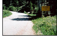
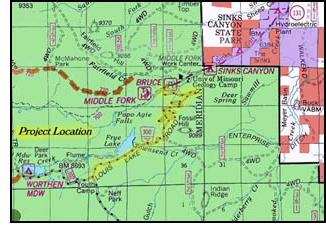
Wyoming Forest Highway 23 (WY FH 23) / Louis Lake Road is located in Fremont County, Wyoming, and links the town of Lander, Wyoming, and the Shoshone National Forest. It is a narrow gravel road with turnouts to better facilitate two vehicles passing at once. The current road design is unsafe and inadequate for expected traffic volume increase as more visitors are drawn to the area.
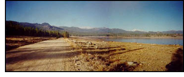 Louis Lake Road provides direct roadside access to an abundance of recreational opportunities, including driving for pleasure, viewing scenery and wildlife, camping, picnicking, lake and stream fishing, hunting, hiking, nature trails, backpacking, rock climbing, cross-country biking, snowmobiling, and cross-country skiing. There are areas of historic significance, including the CCC-constructed facilities, mining sites, and Blue Ridge Historic Lookout. WY FH 23 contributes to the economies of Fremont County and Lander, Wyoming, as it is the primary local access from Lander to the Forest. Increasing interest in the recreational opportunities provided along WY FH 23 indicates a potential for local economic growth in the form of lodging, restaurants, outfitters, and other recreational related businesses and services.
Louis Lake Road also provides access to non-recreational resources of the Forest, which contribute to the local economy. These resources include a managed timber harvest program, pole fencing materials harvest, commercial and residential firewood harvest, community watershed management, and livestock management.
CFLHD administers the surveying, designing and constructing of forest highway system roads, parkways and park roads, bridges, and other Federal Lands roads. CFLHD was interested in using QuickZone for this project primarily because of the public's concern over the economic impacts on the area during construction. Because the road is such a vital link to the Forest, residents of Lander in particular were concerned that real and perceived construction delays would deter vacationers and local businesses would lose revenue. QuickZone was needed to assure the public that the construction schedule chosen was the best of the available options. Further, it allowed CFLHD to give travelers an idea of what delays to expect at different times to help them better plan their trips.
 This was primarily a flagger application of QuickZone, a new feature available in Version 2.0 as well as CFLHD-QuickZone. Being a rural area, the traffic volumes were low and saturated delays were not a concern. The primary means of traffic control were flaggers when the narrow two-lane road was reduced to one-lane, two-way operation, and full closures during rock blasting and other dangerous operations. When full closures do take place, a detour route is available. The diversion point is at the town of Lander which is 15 km from the work zone area. QuickZone estimated the delay a traveler would face at flagging operations of different lengths and capacities, as well as the amount of traffic that might have to take the detour during road closures.
The primary traffic control decisions faced by CFLHD regarding construction phasing were:
- At what times of day and day of the week can the road be closed while minimizing the impact to the traveling public?
- What maximum delay stipulations can reasonably be imposed on the construction contractors?
The construction specification drawn up by CFLHD gives specific allowances for the frequency and times of day the road can be closed and the maximum allowable delay for a traveler traversing the project area. In order to balance the needs of the public with the needs of the contractor, QuickZone was needed to determine reasonable restrictions on construction activity to keep the project on time while still allowing reasonable access to travelers.
5.2.2 Network Design
The project area was 11.5 kilometers in length and was broken down into six work zones as shown in the figure below. The type of work required in each of these areas varied and included blasting rock and building retaining walls, upgrading switchbacks, building culverts, and realigning. Since work at different work zones overlapped, QuickZone was needed to estimate delays at each flagging operation to know whether a traveler could face a proposed series of flaggers and still not exceed the maximum allowable delay. Not only was this important to derive the initial specification, but for CFLHD to intelligently respond to modification requests from the contractor as well.
The network design was straightforward, and included the six work zone links through the project area and a detour which added approximately 50 kilometers to a trip. Since the existing road was narrow and gravel, the capacity was assumed to be a low 600 vehicles per hour. Demand data came from 1997 traffic counts, projected to 2003 at an assumed 2.5% growth rate per year, drawn from the environmental impact statement. Monthly average daily traffic figures ranged from a low of 157 in October to a high of 421 in July. The road would close in October and reopen in May. Required QuickZone data included how traffic volume varied by time of day and day of the week. Since this level of detail was not available for this project, distributions from the Beartooth Highway project were used since the demand characteristics—primarily recreational travel—were sufficiently similar.
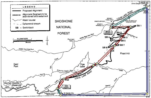
Figure 5.2.1 Louis Lake Road QuickZone Network
5.2.3 Results
Due to the low volumes in the project area, the only delays were caused by the flagger operations. The delays to be expected at a flagger zone are affected by its length because the entire length has to be cleared in one direction before the other direction can be allowed to proceed. At the time of highest demand, at 2pm on Saturdays in July, the demand on Louis Lake Road is 57 vehicles per hour. For a work zone of 3 km and with a clearance time of 13.4 minutes, the maximum user delay is 27.5 minutes. That is, the delay experienced by the vehicle that arrives just as his direction is halted. He would have to wait for the vehicle ahead of him to clear the work zone and wait for the traffic in the other direction to proceed and clear. As the construction specification stipulates that the longest a traveler may be delayed through one work zone is 30 minutes, the longest work zone may be 3 km. if there is only a single work zone in place at a time. If multiple work zones are in place at the same time, each one would clearly have to be shorter. QuickZone can determine the maximum user delays for any combination of multiple work zones.
A major concern of both CFLHD and local residents was the economic impact of the construction. In order to address this issue, CFLHD-QuickZone includes a robust economic impact analysis module, which can estimate the amount of revenue lost by reduced travel, the additional cost to freight traffic, the cost of lost time by delayed travelers, and the additional vehicle operating costs from the additional miles traveled on the detour. The economic analysis will be used by CFLHD to help determine when flagging operations and full closures will be allowed and to assure the public that delay costs and economic impacts to the town of Lander were considered in construction plans.
Currently, CFLHD is in the process of refining the current Louis Lake Road model to determine the effects of potential construction phasing plans. The QuickZone results could be used by CFLHD to adjust their construction specification to either relax or tighten the limits set on the contractor. Further, they could be used to evaluate modification requests to the specification by the contractor. With regard to full closures, simply based on the time of day and day of week demand data, CFLHD could determine how many vehicles would be affected by full closures at all times of day for each day of the week. By setting a cap on the number of vehicles that could be turned back or detoured, CFLHD could control the impact to road users and intelligently direct the construction contractor to when the road may or may not be closed.
5.2.4 Contact Information
Stephanie Popiel
(303) 716-2143
Stephanie.Popiel@fhwa.dot.gov
Burt McCauley
(303) 716-2081
bert.mccauley@fhwa.dot.gov