3.0 Urban Arterial
3.1 Little Bras d'Or Bridge: Nova Scotia, Canada
 Key Observations
- QuickZone enabled the quick testing of a number of alternate phasing plans in order to balance the need for the construction with the political pressure to reduce the overall impact on motorists.
- QuickZone results helped to insure that a work zone with unacceptable delays was avoided.
- Queue lengths and delays estimated by QuickZone were consistent with field observations lending more credibility to the results of various alternate phasing plans.
3.1.1 Overview
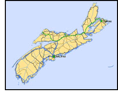
Nova Scotia is one of Canada's smaller provinces and is located on the east coast. The provincial population is just under 1 million. Cape Breton Island is on the north-east tip of Nova Scotia and is connected to the mainland by a man-made causeway. The main road through Nova Scotia is the Trans-Canada Highway that runs through Cape Breton Island and over to the port of North Sydney which provides the ferry link to the province of Newfoundland. The Trans-Canada Highway, along with the port of North Sydney, is the primary link for the movement of people and goods to and from that province.
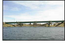 Access to North Sydney from the Trans-Canada highway is only available via two bridges: the Great Bras d'Or and Little Bras d'Or bridges. The Little Bras d'Or bridge provides the only crossing over the Bras d'Or gut which connects Bras d'Or Lake with the Atlantic Ocean. Currents in the gut are very strong as the tides move in and out of an inland lake. In the spring of 2001 a major structural rehabilitation project was started on the Little Bras d'Or bridge which consists of 4 x 100' steel girder spans and was built in 1959.
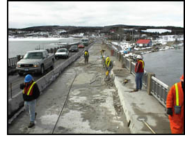
The bridge carries a two lane, two way highway. It was necessary to close one lane to carry out repairs. Traffic flow was controlled by signals, and later during peak traffic flow hours by flaggers. As the project progressed into late spring, traffic volumes increased and motorists began to experience significant delays. Local residents, businesses, politicians and emergency services were very vocal about the delays which resulted. Political pressure forced the work to be rescheduled for November. In anticipation of the November bridge work, the provincial transportation engineer started to look for tools which would help him predict the impact of the proposed closure so that he could make objective decisions on when work could take place. He discovered the QuickZone V 0.99 beta software on the internet and realized the value it could have on testing various approaches to work zone staging for the Little Bras d'Or project.
3.1.2 Network Design
 The network for the Little Bras d'Or bridge is simple in design and consists of six links and four nodes as shown in Figure 3.1.1. The only complication with the Little Bras d'Or network is the existence of two-way one lane operations which QuickZone V 0.99 Beta (and Version 1.0 as well) cannot explicitly handle. Only link 2 of the Little Bras d'Or network was designated as a work zone. Clearly, links 2 and 5 will both be affected by the construction. However, since QuickZone V 0.99 Beta is limited with analyzing flagging operations, each direction of traffic flow had to be analyzed separately. Therefore, only the inbound direction was analyzed since this had the highest demand and would result in the maximum queue and delay for the entire network. QuickZone 2.0 now includes features to directly analyze two way, one-lane operation.
Traffic data was made available through the Nova Scotia Department of Transportation. Hourly traffic volume data was obtained from the Department's Traffic Census Team. The traffic census data is not available on-line so specific requests were made to the Traffic Census Team for information on each site studied. Turn around time for data was usually within 24 hours. This data was only been available in "raw" counts, so some re-calculation was required in order to develop the necessary daily and hourly demand factors which QuickZone uses for its demand inputs. Seasonality factors were also available for each highway section from the Traffic Census Team. Most traffic data is unclassified so assumptions were made for percent of heavy vehicles.
A critical factor to provide accurate predictions is to accurately estimate the work zone capacity. While QuickZone does not directly estimate capacity loss due to a work zone (some guidelines based upon the Highway Capacity Manual are included), there is a fair amount of research available on multi-lane highways, but very little on two lane two-way highways under a full lane closure. Estimates of capacity loss were based upon observations made on various types of sites over the past few years.
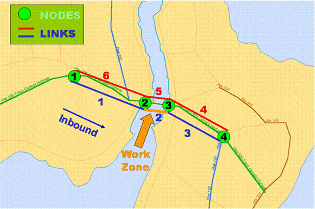
Figure 3.1.1 Little Bras d'Or Bridge QuickZone Network
3.1.3 Results
Due to political pressure, the initial construction project was stopped and basic repairs were made in order to keep the bridge safely open until a better solution could be found so as to not impact motorists as much. In 2004, the initial analysis performed at this site was updated for a milling and repaving project on the same section of highway. QuickZone was used to support the decision to do the work at night and also to define the nighttime work hours, which would have to be followed by the contractor. It is anticipated that the structural repairs started in 2001 will re-start and be finished in 2005.
3.1.4 Contact Information
Gerard Kennedy, P.Eng.
Project Engineer
Nova Scotia Dept. of Transportation & Public Works
P.O. Box 1180 Sydney, N.S. B1P 6J9
902.563.2518
kennedge@gov.ns.ca
3.2 Reeves Street: Nova Scotia, Canada
Key Observations
- Simple intersection analysis can be conducted with QuickZone to identify possible queuing and delay.
- QuickZone provided the analytical backup to effectively demonstrate the advantages of night-time construction.
- Queue length and delays predicted by QuickZone were consistent with field observations.
3.2.1 Overview
Nova Scotia is one of Canada's Atlantic maritime provinces located on the east coast with a provincial population just under 1 million. Nova Scotia is composed of several islands and peninsulas with key commercial and population centers connected by the Trans Canada Highway. Port Hawkesbury is a key commercial location on Cape Breton Island just south of the Trans Canada Highway. The town of Port Hawkesbury includes a number of major industrial facilities representing companies such as Georgia-Pacific, Statia Terminals, USG, and the Sable Offshore Oil Company. The town also includes a number of residential communities.
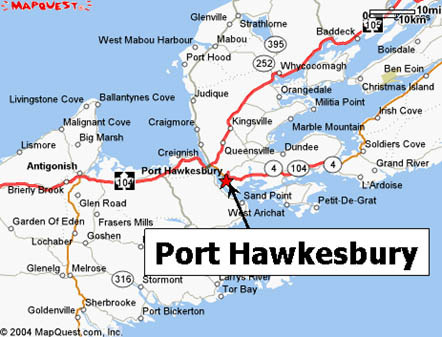
Figure 3.2.1 Port Hawkesbury, NS
In 2001, the intersection of Reeves Street and Trunk 4 in Port Hawkesbury, a location along a key access route to the Trans Canada Highway, was slated to be upgraded. Both Reeves Street and Trunk 4 are generally 2-lane highways with certain sections upgraded to include designated turn lanes in built-up areas. Average Annual Daily Traffic (AADT) was on the order of 8,000 vehicles per day with approximately 10% of those being trucks. Truck traffic is concentrated during the daytime on weekdays, while trucks make up fewer than 5% of traffic volume on weekends. Most of the traffic volume at this location in Port Hawkesbury is through traffic continuing on to some of the industrial centers near the town or to points further north.
The reconstruction involved a major upgrade of the intersection including additional dedicated turn lanes to accommodate higher traffic volumes and to improve safety. In order for construction to take place, overall capacity of the intersection would be reduced due to narrow lanes widths and periodic lane closures. Construction was slated to take place only during daylight hours because of cost and safety concerns. However, it was also evident that any construction taking place during the day would have an impact on motorists, since the Reeves Street/Trunk 4 intersection carries a large amount of traffic. Therefore, in order to reduce the impact to motorists as much as possible, QuickZone Version 1.0 was used to test various construction phasing alternatives, including analyzing the possibility of a detour route, and to also provide the necessary data to justify the additional expense of night work.
3.2.2 Network Design
The network for the signalized Reeves Street intersection is a fairly basic design and consists of 12 links and 6 nodes including a detour route as shown in figure 3.2.2 below. As shown in figure 3.2.3 below, Reeves Street ends at a "T" intersection with roads Trunk 4 and Trunk 4a. The left turning movement continues on to Trunk 4 and carries most of the traffic volume. The right turning movement continues on to Trunk 4a and terminates shortly thereafter in large industrial area. In order for QuickZone to analyze the intersection, only the left turning movement headed north-east and the right turn movement headed south-west were modeled. This can be considered a corridor unto itself with the capacity limited primarily by the left turning movement lanes and signal phasing. The detour route consisted of Sydney Road which cut through a mostly residential section.
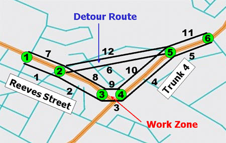
Figure 3.2.2 Reeves Street QuickZone Network
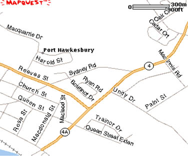
Figure 3.2.3 Reeves Street Intersection
Detailed traffic data was available for this intersection from a traffic study which was carried out in 2000. The demand data, along with the signal timing plans, helped to determine the capacity of the intersection. Thus, the capacities of the various turning movements helped to determine the capacity of each link. Capacities under work zone conditions were estimated by the engineer from prior experience with flagging operations. The capacity and demand along the detour route was measured during the peak periods and on weekends by hand.
3.2.3 Results
The local engineers suspected that the reconstruction of the Reeves Street intersection would result in significant queuing and delay and that doing the construction at night could potentially mitigate many of these impacts. Initial results from QuickZone proved these suspicions and showed an estimated maximum queue of 4.1 miles resulting in a 70 minute delay occurring on Friday evenings. Queuing and delay were also seen on Monday, Tuesday, Wednesday and Thursday but were approximately half the length and duration as seen on Friday evenings. Detour traffic was estimated at 10,000 vehicles per week. Knowing that the queuing, delay and detour volumes through the residential areas would be contentious issues with residents, the local engineers tested various construction phasing scenarios with QuickZone.
The first QuickZone analysis had the work zone in place and operating with reduced capacity 24 hours a day, 7 days a week. Queuing during the day on Friday and Saturday were predicted to be especially severe. The engineers noted that queuing and delay did not form during the overnight hours on any day and tested a scenario that eliminated construction during daylight hours on Friday and Saturday (essentially shifting work to night). The results of this scenario cut in half the queuing and delay associated with the construction to 2.19 miles and 36.4 minutes respectively. In addition, the number of weekly vehicles on the detour route was reduced to 6,000, a 40% reduction.
Additional refinements in the work zone design, including tweaking the hours and days of operation, enabled the engineers to better schedule the construction activities so as to not impact motorists. Also, the Nova Scotia Department of Transportation & Public Works did not have a night-time construction policy and did not routinely approve projects for night work due to cost and safety concerns. Because of the results generated by QuickZone, the decision was made to carry out some of the most disruptive phases of construction at the Reeves Street intersection at night.
3.2.4 Contact Information
Gerard Kennedy, P.Eng.
Project Engineer
Nova Scotia Dept. of Transportation & Public Works
P.O. Box 1180 Sydney, N.S. B1P 6J9
902.563.2518
kennedge@gov.ns.ca