Regional Assessment of Weather Impacts on Freight
Chapter 1. Introduction
Background
This project follows up on a study completed for the Federal Highway Administration (FHWA) in 2012 that provided a national estimate of weather-related delay affecting the trucking industry. The initial estimate indicated that weather-related delay costs the industry $8 billion to $9 billion annually. The goal of this study is to conduct a more detailed assessment of the impacts of adverse weather on freight movement in 13 diverse geographic regions, including both urban and rural corridors. The objective is to provide greater temporal and geographic detail than the first phase study allowed, and use the results to refine the previously developed weather adjustment factors, enabling an overall increased confidence in the 2012 nationwide study.
Commercial motor vehicles are the nation's dominant mode of freight transportation. Estimates of the transportation component of the nation's freight are upwards of $600 billion of total gross domestic product. It is estimated that 70 percent of this total value and 60 percent of its total weight move by truck. Weather-related delays can add significantly to shipping costs, resulting in negative impacts on the overall economy.
Adverse weather is one of the major causes of delay on the roadway system. The FHWA Road Weather Management Program Web site reports that as much as 23 percent of the Nation's roadway delays may be the result of adverse weather. Other studies show a lower, but still very significant, percentage of adverse weather-related delays; yet others identify a wide variation in adverse weather impact on speed, volume, and delay, as shown below in table 1 also from the FHWA Road Weather Management Web site. Table 2 summarizes the results of research funded by FHWA.
Table 1. Freeway traffic flow reductions due to weather.
| Weather Conditions |
Freeway Traffic Flow Reductions—Average Speed |
Freeway Traffic Flow Reductions—Free-Flow Speed |
Freeway Traffic Flow Reductions—Volume |
Freeway Traffic Flow Reductions—Capacity |
| Light Rain/Snow |
3% to 13% |
2% to 13% |
5% to 10% |
4% to 11% |
| Heavy Rain |
3% to 16% |
6% to 17% |
14% |
10% to 30% |
| Heavy Snow |
5% to 40% |
5% to 64% |
30% to 44% |
12% to 27% |
| Low Visibility |
10% to 12% |
 |
|
12% |
Source: How Do Weather Events Impact Roads?
Table 2. Empirical studies on weather and traffic.
| Traffic Parameter |
Weather Condition |
Weather Condition Parameter |
Range of Impact |
| Free-Flow Speed |
Light Rain |
<0.01 cm/h |
-2% to -3.6% |
| Free-Flow Speed |
Rain |
~1.6 cm/h |
-6% to -9% |
| Free-Flow Speed |
Light Snow |
<0.01 cm/h |
-5% to -16% |
| Free-Flow Speed |
Snow |
~0.3 cm/h |
-5% to -19% |
| Speed at Capacity |
Light Rain |
~0.3 cm/h |
-8% to -10% |
| Speed at Capacity |
Rain |
~1.6 cm/h |
-8% to -14% |
| Speed at Capacity |
Light Snow |
<0.01 cm/h |
-5% to -16% |
| Speed at Capacity |
Snow |
~0.3 cm/h |
-5% to -19% |
| Capacity |
Light Rain |
<0.01 cm/h |
-10% to -11% |
| Capacity |
Rain |
~1.6 cm/h |
-10% to -11% |
| Capacity |
Light Snow |
<0.01 cm/h |
-12% to -20% |
Source: Presentation "Federal Program for Weather-Responsive Traffic Management," presented by Roemer Alfelor, Ph.D., FHWA, at Northwest Transportation Conference, Oregon State University, March 2014.
An important focus of this project is to better identify weather condition parameters specific to commercial vehicles, and to possibly expand the range of weather condition indices beyond those identified above.
Purpose of Study
The results of the first-phase study were presented at a number of conferences and meetings since 2012. The responses to these presentations were enthusiastic, especially from State Departments of Transportation (DOT) and transportation logistics companies. These responses highlighted the importance of this analysis in promoting the need for investment in weather-related maintenance and traffic management activities, improved surface weather condition data, improved weather forecasting, and the dissemination of readily available real-time data oriented toward the freight industry. Some of these investments are in the realm of the public sector, while others will be made by the private sector. While safety remains a central motivation in promoting weather-related transportation programs, there is a clear economic imperative as well. Efficient movement of goods is becoming more critical to all segments of the economy. For example, just-in-time manufacturing and real-time inventory control both require and depend on deliveries within ever more precise time windows. A better understanding of weather impacts on travel speeds can help provide the freight industry and its customers with more accurate predictive information on travel times and support the implementation of weather-responsive traffic management strategies. Providing fact-based data to a freight industry that now depends on a more instant world could potentially allow companies to mitigate their costs by incorporating freight-shipping models to account for adverse weather patterns. They could choose to ship products early, later, or stop midway through an adverse weather event. Understanding the economic impacts helps to make the case for winter maintenance budgets and for development and deployment of new technologies that will enable those funds to be spent more cost effectively.
Finally, with this understanding of the real cost of adverse weather impacts on freight traffic, FHWA hopes to stimulate research into new safety measures for freight corridors. For example, the fog-alert system implemented by the Tennessee DOT along I-75 near Calhoun, Tennessee, has greatly decreased the number of fog-related crashes in that fog-prone area through the use of advanced road weather management technology.
Goals and Objectives
The primary goal of this study is to estimate the impact of adverse weather on the freight industry in 13 diverse regions in the U.S. Impacts include estimates of travel delay resulting from specific weather phenomena, and the economic impacts of these delays. This effort builds upon the work completed in 2012 discussed earlier by increasing the level of temporal and geographic details in the estimates. This project does not involve the development of a revised national estimate, but the findings could be used to develop one in the future. Specific objectives include:
- Estimates of weather-related delay under a variety of weather conditions.
- Estimates of weather-related delay in a variety of geographic settings.
- Estimates of weather-related delay in a variety of terrain.
- Estimates of weather-related delay in a variety of economic regions.
Another objective is to examine the effectiveness of different data sources in helping to estimate weather-related trucking delay.
Overview of Candidate Datasets and Methodology
This section summarizes criteria used to select key data sets and the overall approach to conducting the project.
Criteria for Selecting Data Sets
Descriptions of key data sources are discussed briefly below.
- Weather Data. There is a wide-range of weather data sources that can be used to help identify when traffic is being impacted by adverse weather. In order to be effective in this analysis, however, weather data must have the temporal and geographic detail necessary to match weather events with traffic flows. Issues related to data formats must also be considered; datasets that require excessive processing time or interpretation may not be feasible to use within the existing work scope and budget. After evaluating several approaches, the National Oceanic and Atmospheric Administration's (NOAA) Storm Events Database was used as the primary weather data source for this effort. The Methodology section of this technical memorandum details the weather sources evaluated and provides more detail on the weather dataset used in the analysis.
- Travel-Time Data. In order to conduct the proposed analysis, data are required for truck travel times, truck volumes, and value of truck shipments. The National Performance Management Research Data Set (NPMRDS) was proposed for use in calculating truck travel times. This information was originally used in the 2012 study, at a time when the data was provided by the American Transportation Research Institute (ATRI). The ATRI database is now part of the NPMRDS and available through FHWA. The roadway network has been expanded and speed data are available for trucks at 5-minute intervals. The NPMRDS allows consistency across all regions considered in the study, as well as with the previous 2012 study. However, as the analysis went forward many of the truck speed observations were not consistent with the speed observations for passenger vehicles and total traffic. In general, truck speeds should not be expected to vary significantly from those of the general traffic stream, and so the general traffic speed estimates, which have the largest sample size (combined passenger and freight vehicles), were used in the analysis.
- Freight Data. In order to estimate the economic impact of delay, the number of trucks using the study area roads and some measure of their economic value are necessary. The project team determined that both can be obtained from the Freight Analysis Framework Version 3.5 (FAF3.5), which is described in more detail in the Methodology section of this report. The FAF, like NPMRDS, provides a consistent source of national information that can be used to derive estimates of truck volumes on National Highway System roads, as well as commodity value. These estimates can be compared to those in the FTR Transportation Intelligence model used in the 2012 study because the team used the 2012 provisional data provided in the FAF3.5. This provisional data set (2012 freight data) was converted to a trip table and assigned to the network to produce flows using an algorithm approved by the FHWA. (FHWA Freight 2011—FAF Geospatial Support and Special Tabulations. Project number 008500.003.)
- Congestion Data. As noted in the work scope, the level of congestion will have a major impact on the value of the weather index. Speeds tend to drop more significantly during adverse weather on roads that are approaching capacity. The empirical tests using the data sources above provided a good measure of congestion, which could be identified during periods of good weather.
Methodology Summary
Figure 1 provides an overview of the proposed methodology for the study. As shown, a series of travel-time comparisons were developed for different weather conditions. While weather phenomena are dependent on the specific region included in the analysis, the initial set of tests focused on as wide a range of weather phenomena as possible. Case studies were selected to represent as wide a range of conditions as possible, using the following criteria:
- Population Size.
- Density.
- Estimated Level of Trucking Activity.
- Commodities Moving Into, Out of and Through the Area.
- Terrain.
- Economic Base.
- Climate.
- Perceived Level of Congestion.
Roadways within the study areas were selected based on their location within the metropolitan area (urban, suburban, exurban).
Figure 1. Flowchart. Analysis Approach.
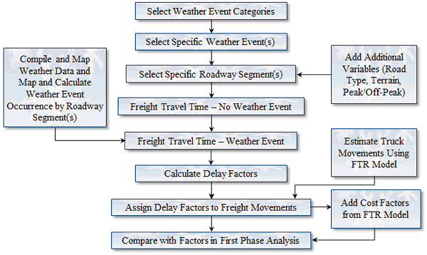
(Source: Cambridge Systematics, Inc.)
The following sections describe the analytical work conducted, the distribution of cases, and the data sets used for the analysis.
You may need the Adobe® Reader® to view the PDFs on this page.