4.4.3.2 Traffic-Related Functional Flow Diagrams
Issues surrounding the control and surveillance of traffic are key components
of any ITS regional deployment and depend upon the coordination of multiple
entities. The Functional Flow Diagrams presented in this section all revolve
around how traffic control and surveillance are and could be provided. Please
refer to the narratives associated with each flow diagram for specific explanations
of each element.
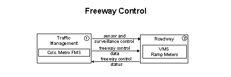
The Freeway Control functional flow diagram provides a basic
representation of the types of communications and roadside equipment needed
to control the major aspect of central Ohio's freeway systems; e.g., ramps,
lanes and interchanges. Coordination and integration of ramp meters are also
included here. This flow diagram is consistent with typical urban traffic
freeway control systems. It incorporates the instrumentation included in the
Network Surveillance functional flow diagram to support freeway
monitoring and includes the capability to use surveillance information to
detect incidents on the freeway. Additionally, this flow diagram illustrates
how general advisory and traffic control information can be provided to the
traveler while en route. In central Ohio this functional flow diagram is linked
closely with the Surface Street Control functional flow diagram
because the plans for the Columbus Metropolitan Freeway Management System
are to be tightly integrated with the city of Columbus' signal system.
 Traffic
Management's freeway control functions will be performed by the Columbus
Metropolitan Freeway Management System. In central Ohio control is achieved
by two means: ramp meters and VMS. Ramp meters are currently in operation
and controlled by the city of Columbus' TMC, and VMS's will come on line with
the Columbus Metropolitan Freeway Management System. Operators at the Columbus
Metropolitan Freeway Management System, working with the city of Columbus'
TMC, will have the capability to control the flow of traffic on the freeways
by modifying ramp meter parameters. Furthermore, they will be able to potentially
divert traffic by providing travelers with incident and congestion information
through the VMS. This control will be done in conjunction with the use of
the surveillance equipment outlined in the Network Surveillance
functional flow diagram. Surveillance equipment includes: loops in the pavement
to provide flow and speed data and CCTV cameras to provide images of the freeway
itself. This instrumentation will exist not only on the freeways but on selected
major arterials as well.
Traffic
Management's freeway control functions will be performed by the Columbus
Metropolitan Freeway Management System. In central Ohio control is achieved
by two means: ramp meters and VMS. Ramp meters are currently in operation
and controlled by the city of Columbus' TMC, and VMS's will come on line with
the Columbus Metropolitan Freeway Management System. Operators at the Columbus
Metropolitan Freeway Management System, working with the city of Columbus'
TMC, will have the capability to control the flow of traffic on the freeways
by modifying ramp meter parameters. Furthermore, they will be able to potentially
divert traffic by providing travelers with incident and congestion information
through the VMS. This control will be done in conjunction with the use of
the surveillance equipment outlined in the Network Surveillance
functional flow diagram. Surveillance equipment includes: loops in the pavement
to provide flow and speed data and CCTV cameras to provide images of the freeway
itself. This instrumentation will exist not only on the freeways but on selected
major arterials as well.
 As
noted in 1, Traffic Management's control
of the Roadway, in this case the freeways, will be conducted
by the Columbus Metropolitan Freeway Management System. The ramp meters and
VMS will receive control information from the Columbus Metropolitan Freeway
Management System and provide back system status information. Additionally,
the surveillance equipment installed on the freeway, loops and CCTV cameras
will provide traffic flow information and traffic images as well as status
of the equipment itself.
As
noted in 1, Traffic Management's control
of the Roadway, in this case the freeways, will be conducted
by the Columbus Metropolitan Freeway Management System. The ramp meters and
VMS will receive control information from the Columbus Metropolitan Freeway
Management System and provide back system status information. Additionally,
the surveillance equipment installed on the freeway, loops and CCTV cameras
will provide traffic flow information and traffic images as well as status
of the equipment itself.
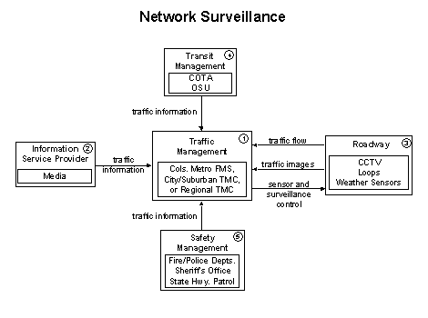
This functional flow diagram provides a basic representation of how information
on travel conditions is collected and distributed. Network Surveillance
represents a summary or macro level presentation of surveillance on both central
Ohio's freeways and surface streets. Both of these are broken out in greater
detail, to include both surveillance and control, with their own functional
flow diagrams: Surface Street Control and Freeway
Control.
Traffic
Management's Network Surveillance functions will be performed by
the Columbus Metropolitan Freeway Management System, other TMCs in the region
(i.e., city of Columbus TMC, city of Dublin TMC) or a Regional Transportation
Management Center. These elements should work in an atmosphere of cooperation
and integration to the greatest extent possible. Some level of integration
is already planned. For example, the Columbus Metropolitan Freeway Management
System will be integrated with the city of Columbus' signal system as part
of Phase 2 of the city's Y2K mitigation program. Furthermore, the cities of
Dublin and Gahanna have shown interest in receiving the surveillance feed
from the Columbus Metropolitan Freeway Management System. This feed would
allow the city of Dublin's TMC the ability to access all the information being
gathered from the Region's Freeway Management System to include: images from
the CCTV cameras along the freeways and major arterials, messages being displayed
on the VMS and the traffic flow map. They will also have the capability to
control the CCTV cameras near their jurisdiction. This capability could be
preempted by the region's Freeway Management System Control Center in case
of an emergency. Other traffic management centers (e.g., city of Gahanna)
have indicated interest in receiving this feed and have their own similar
Network Surveillance capability.
As
noted in 1, Traffic Management centers around
central Ohio will be gathering a great deal of Network Surveillance
information. However, in order to decrease congestion and improve travel in
general to the greatest degree, this information must be provided to the traveler.
For this flow diagram the Traffic Management centers will
interact with the Information Service Provider by receiving
traveler information from sources such as local television stations. For example,
Channel 4 in Columbus currently provides information to the city of Columbus'
Traffic Management Center. This relationship, to include type/level of information
and potential Information Service Providers, is explained
in greater detail in the Traveler Traffic Information, Broadcast Traveler
Information and Interactive Traveler Information
functional flow diagrams.
 As
noted in 1, surveillance information at the Roadway
will be provided to Traffic Management centers and then disseminated
to Information Service Providers and ultimately to the traveler. The information
provided will be gathered through a variety of means. These include loops
in the pavement to provide flow and speed data and CCTV cameras to provide
images of the network itself. This instrumentation will exist on freeways
and major state routes as part of the deployment of the Columbus Metropolitan
Freeway Management System, but is available today on surface street systems
that include the city of Columbus' signal system; e.g. city of Dublin, city
of Hilliard, city of Gahanna, etc. As noted in 1, an ultimate
goal of a regional approach toward integrating these systems would be the
ability to share the information gathered from a variety of sources and jurisdictions
with each other. Although the Columbus Metropolitan Freeway Management System
will be central Ohio's major data resource, the sharing of multiple jurisdiction
traffic information will provide traffic management center operators with
the ability to solve traffic problems in their jurisdictions more efficiently.
For example, by having more eyes on the entire system, operators could anticipate
problems due to an incident outside their jurisdiction and react to the additional
traffic being generated now diverting onto their system in a more timely manner.
Furthermore, ODOT's road weather system provides information on ice/snow/rain
conditions to various TMCs around the state. This represents another type
of information capable of being integrated.
As
noted in 1, surveillance information at the Roadway
will be provided to Traffic Management centers and then disseminated
to Information Service Providers and ultimately to the traveler. The information
provided will be gathered through a variety of means. These include loops
in the pavement to provide flow and speed data and CCTV cameras to provide
images of the network itself. This instrumentation will exist on freeways
and major state routes as part of the deployment of the Columbus Metropolitan
Freeway Management System, but is available today on surface street systems
that include the city of Columbus' signal system; e.g. city of Dublin, city
of Hilliard, city of Gahanna, etc. As noted in 1, an ultimate
goal of a regional approach toward integrating these systems would be the
ability to share the information gathered from a variety of sources and jurisdictions
with each other. Although the Columbus Metropolitan Freeway Management System
will be central Ohio's major data resource, the sharing of multiple jurisdiction
traffic information will provide traffic management center operators with
the ability to solve traffic problems in their jurisdictions more efficiently.
For example, by having more eyes on the entire system, operators could anticipate
problems due to an incident outside their jurisdiction and react to the additional
traffic being generated now diverting onto their system in a more timely manner.
Furthermore, ODOT's road weather system provides information on ice/snow/rain
conditions to various TMCs around the state. This represents another type
of information capable of being integrated.
 Network
Surveillance will also be gathered via COTA's and OSU's Transit
Management centers' network of coaches operating on the surface streets
around the county. COTA is in the initial stages of implementing AVL which
will provide Traffic Management centers with an additional
surveillance resource as the coaches act as probes on the region's surface
streets. OSU currently has an AVL system installed on its coach fleet. This
is explained in much greater detail in the Transit Vehicle Tracking
functional flow diagram.
Network
Surveillance will also be gathered via COTA's and OSU's Transit
Management centers' network of coaches operating on the surface streets
around the county. COTA is in the initial stages of implementing AVL which
will provide Traffic Management centers with an additional
surveillance resource as the coaches act as probes on the region's surface
streets. OSU currently has an AVL system installed on its coach fleet. This
is explained in much greater detail in the Transit Vehicle Tracking
functional flow diagram.
 Safety Management centers also play a key role in providing
surveillance information to Traffic Management centers. The
City of Columbus Division of Police has discussed gaining the ability to receive
Network Surveillance information from the region's Freeway
Management System at a mobile Incident Command Center. This mobile center
could then, in turn, provide audio and video updates on incidents the police
are working on. The City of Columbus Division of Police's helicopter could
also provide live video updates to Traffic Management during
incidents on the Roadway.
Safety Management centers also play a key role in providing
surveillance information to Traffic Management centers. The
City of Columbus Division of Police has discussed gaining the ability to receive
Network Surveillance information from the region's Freeway
Management System at a mobile Incident Command Center. This mobile center
could then, in turn, provide audio and video updates on incidents the police
are working on. The City of Columbus Division of Police's helicopter could
also provide live video updates to Traffic Management during
incidents on the Roadway.
Police and fire divisions currently provide Traffic Management
centers with updates on incident information indirectly. Both organizations
operate with an 800MHz-radio system. Traffic Management centers
can then monitor the radio traffic to receive incident updates. This link
is not as dependable as it could be, and represents an opportunity for improved
integration among organizations.
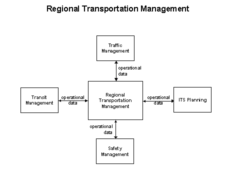
This functional flow diagram provides capabilities for analyzing, controlling,
optimizing and integrating Regional Transportation Management.
These capabilities provide for regional optimization and integrated control
of network signal systems with freeway control and coordination of area transit
and emergency service providers. These capabilities could be provided by a
Regional Transportation Management Center (RTMC) that integrates the operations
and communications of all salient transportation stakeholders, including traffic,
transit, safety, and planning.
Regional Transportation Management can be achieved through
a centrally located RTMC or through a virtual management center involving
linked, distributed workstations. The RTMC could be able to communicate with
other TMCs in order to receive and transmit traffic information on other jurisdictions
within the region.
The RTMC could also support any other demand management policies that can
alleviate congestion and influence mode selection. It may also communicate
with other transportation management centers to coordinate traffic information
and control strategies in neighboring jurisdictions.
A central Ohio RTMC could include the following stakeholders: Columbus Metropolitan
Freeway Management System, city traffic signal systems, Franklin County Emergency
Management Agency, COTA communication facility and the City of Columbus' EOC.
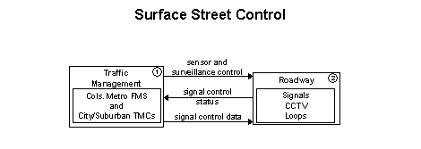
The Surface Street Control functional flow diagram provides
a basic representation of the central control and monitoring equipment, communication
links, and the signal control equipment that support local surface street
control and/or arterial traffic management. A range of traffic signal control
systems is represented in this diagram, ranging from static pre-timed control
systems to full traffic responsive systems that dynamically adjust control
plans and strategies based on current traffic conditions and priority requests.
Additionally, general advisory and traffic control information can be provided
to the driver while en-route. This diagram is generally an intra-jurisdictional
package and does not rely on real-time communications between separate control
systems to achieve area-wide traffic signal coordination. Systems that achieve
coordination across jurisdictions by using a common time base, or other strategies
that do not require real-time coordination, could also be represented by this
diagram. Its should be noted that this type of coordination is currently being
done between the city of Columbus and some suburban cities such as Bexley
and Whitehall. However, for this coordination to take place, the city of Columbus
must operate its signals from its TMC. There is an interest to provide this
type of coordination without the suburban city having to relinquish control.
This functional flow diagram is consistent with typical urban traffic signal
control systems. It incorporates the instrumentation included in the Network
Surveillance functional flow diagram to support freeway monitoring.
In central Ohio this market package is linked closely with the Freeway
Control functional flow diagram due to the plans for the Columbus
Metropolitan Freeway Management System being tightly integrated with the city
of Columbus' traffic signal system and TMCs.
Traffic
Management in this diagram includes the Columbus Metropolitan Freeway
Management System, other traffic management centers in the region (i.e., city
of Columbus TMC, city of Dublin TMC) or a Regional Transportation Management
Center. Surface Street Control; i.e., the capability to control
traffic signals at major intersections and on main highways for urban areas
in central Ohio, is achieved by a variety of types of signal systems including
timed and closed loop. Traffic Management center operators
will be able to modify signal systems in response to incidents, special events
and other unplanned high levels of congestion. Some of the local TMCs (city
of Columbus, city of Gahanna) augment their Surface Street Control
by surveillance provided by loops and CCTV cameras located around the city.
City TMCs also utilize pavement loop detectors for surveillance of the surface
street system.
As
noted in 1, Traffic Management's control
of the Roadway, or in this case surface streets, is conducted
through the use of open and closed loop signal systems. These systems are
controlled by Traffic Management centers and provide equipment
status information. Furthermore, surveillance information is provided by pavement
loop detectors and CCTV cameras, as well as status of the equipment itself.
It is important to note that due to Ohio's home rule environment this functional
flow diagram is currently generally constrained to a single jurisdiction.
previous page | next page
