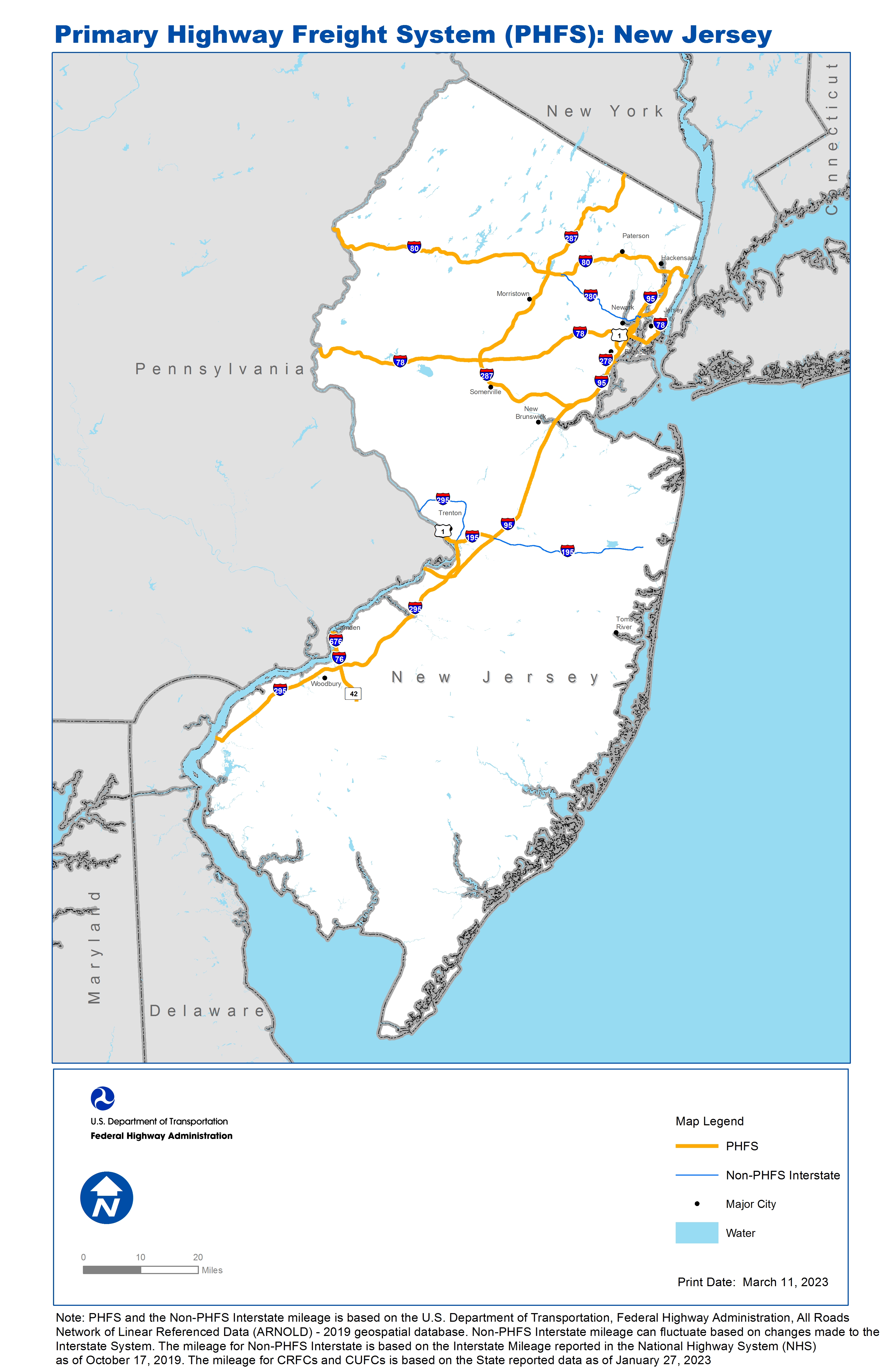
National Highway Freight Network Map and Tables for New Jersey, 2022

High-Resolution Images
- JPG 3.1MB
Table of National Highway Freight Network Routes, 2022
State |
Route No/ Facility Name |
Start Point |
End Point |
Route/Facility Description |
Length (Miles) |
|---|---|---|---|---|---|
NJ |
I195 |
I295 |
I95 |
I195 from I295 to I95 |
6.86 |
NJ |
I278 |
I95 |
NJ/NY Line |
I278 from I95 to NJ/NY Line |
0.59 |
NJ |
I280 |
I95 |
2.81 Miles West of I95 |
I280 from I95 to 2.81 Miles West of I95 |
0.00 |
NJ |
I287 |
I95 |
NJ/NY Line |
I287 from I95 to NJ/NY Line |
67.50 |
NJ |
I295 |
PA/NJ Line |
S29 |
I295 from PA/NJ Line to S29 |
60.17 |
NJ |
I676 |
PA/NJ Line |
I76 |
I676 from PA/NJ Line to I76 |
4.69 |
NJ |
I76 |
PA/NJ Line |
I295 |
I76 from PA/NJ Line to I295 |
3.11 |
NJ |
I78 |
PA/NJ Line |
S139 |
I78 from PA/NJ Line to S139 |
66.37 |
NJ |
I80 |
PA/NJ Line |
I95 |
I80 from PA/NJ Line to I95 |
68.49 |
NJ |
S81 |
U1 |
I95 |
S81 from U1 to I95 |
1.36 |
NJ |
I95 |
I276 |
NJ/NY Line |
I95 from I276 to NJ/NY Line |
86.76 |
NJ |
S29 |
I295 |
U1 |
S29 from I295 to U1 |
3.38 |
NJ |
S42 |
Atlantic City Expwy |
I295 |
S42 from Atlantic City Expwy to I295 |
7.21 |
NJ |
U1 |
PA/NJ Line |
S21 |
U1 from PA/NJ Line to S21 |
0.10 |
NJ |
U1 |
S81 |
U1-T |
U1 from S81 to U1-T |
5.13 |
PHFS Total |
|
|
|
|
381.72 |
State |
Route No/ Facility Name |
Start Point |
End Point |
Route/Facility Description |
Length (Miles) |
|---|---|---|---|---|---|
NJ |
I195 |
I95 |
S34 |
I195 from I95 to S34 |
27.30 |
NJ |
I278 |
U1 |
I95 |
I278 from U1 to I95 |
1.49 |
NJ |
I280 |
I80 |
0.21 Miles East of S21 |
I280 from I80 to 0.21 Miles East of S21 |
14.67 |
NJ |
I295 |
I195 |
PA/NJ Line |
I295 from I195 to PA/NJ line |
16.56 |
NJ |
I78 |
0.1 Miles West of Monmouth St |
NY/NJ Line |
I78 from 0.1 Miles West of Monmouth St to NY/NJ Line |
1.54 |
NJ |
I280 |
0.02 Miles West of Passaic Ave. |
I95 |
I280 from 0.02 Miles West of Passaic Ave. |
3.51 |
INTERSTATE NON-PHFS Total |
65.07 |
Note: PHFS and the Non-PHFS Interstate mileage is based on the U.S. Department of Transportation, Federal Highway Administration, All Roads Network of Linear Referenced Data (ARNOLD) - 2019 geospatial database. Non-PHFS Interstate mileage can fluctuate based on changes made to the Interstate System. The mileage for Non-PHFS Interstate is based on the Interstate Mileage reported in the National Highway System (NHS) as of October 17, 2019. The mileage for CRFCs and CUFCs is based on the State reported data as of January 27, 2023
Sources
U.S. Department of Transportation, Federal Highway Administration, Freight Analysis Framework,
Version 4, 2015, Highway Performance Monitoring System 2012.