<Back to ITS in Work Zones
Intelligent Transportation
Systems
in Work Zones
A Case Study
Real-Time Work Zone Traffic Control System
Using an Automated Traffic Information
System to Reduce Congestion
and Improve
Safety During Reconstruction of the
I-55 Lake
Springfield Bridge in Illinois
October 2004
FHWA-HOP-04-018
EDL# 13984
FHWA
Notice
The Federal Highway Administration provides high-quality information
to serve Government, industry, and the public in a manner that promotes public understanding. Standards
and policies are used to ensure and maximize the quality, objectivity, utility, and integrity of its
information. FHWA periodically reviews quality issues and adjusts its programs and processes to ensure
continuous quality improvement. |
Foreword
Dear Reader,
We have scanned the country and brought together the collective wisdom and expertise of transportation experts implementing Intelligent Transportation Systems (ITS) projects across the United States. This information will prove helpful as you set out to plan, design, and deploy ITS in your communities.
This document is one in a series of products designed to help you provide ITS solutions that meet your local and regional transportation needs. The series contains a variety of formats to communicate with people at various levels within your organization and among your community stakeholders:
- Benefits Brochures let experienced community leaders explain in their own words how specific ITS technologies have benefited their areas.
- Cross-Cutting Studies examine various ITS approaches that can be taken to meet your community's goals.
- Case Studies provide in-depth coverage of specific approaches taken in real-life communities across the United States.
- Implementation Guides serve as "how to" manuals to assist your
project staff in the technical details of implementing ITS.
ITS has matured to the point that you are not alone as you move
toward deployment. We have gained experience and are committed
to providing our state and local partners with the knowledge they
need to lead their communities into the future.
The inside back cover contains details on the documents in this series,
as well as sources to obtain additional information. We hope you find
these documents useful tools for making important transportation
infrastructure decisions.
Sincerely,

Jeffrey F. Paniati
Associate Administrator for Operations
Acting Program Manager, ITS Joint Program Office
Federal Highway Administration
Preface
This case study is one in a series of documents that examines the use
of Intelligent Transportation Systems (ITS) in work zones. More
information on applications of ITS in work zones is available in the
companion document, Intelligent Transportation Systems in Work Zones —
A Cross-Cutting Study (Report No. FHWA-OP-02-025, EDL # 13600).
This case study presents information gathered in interviews with key
personnel on the Lake Springfield Bridge project on Interstate 55 south
of Springfield, Illinois. Some of the information and photos were
obtained during a site visit. The authors greatly appreciate the
cooperation of the Illinois Department of Transportation and its
partners, who made the production of this document possible.
Contents
Project and System Background
This case study focuses on the use of ITS to support Illinois Department
of Transportation (IDOT) work zone operations for a major bridge
and highway reconstruction effort on Interstate 55 (I-55) just south of
Springfield. IDOT chose to deploy ITS for this project as a means to
reduce congestion and improve safety based on its favorable experience
with ITS on other projects. The ITS application, the Real Time Traffic
Control System (RTTCS), covered the northbound and southbound
approaches to the work zone, encompassing approximately 40 miles
of I-55.
The RTTCS consisted of portable dynamic message signs (DMSs),
portable traffic sensors, and portable closed-circuit television (CCTV)
cameras linked via wireless communications to a central workstation.
The system monitored traffic along I-55, automatically generated
messages on the DMSs based on predefined thresholds, provided
data for a real-time congestion map displayed on IDOT's website,
and provided congestion/incident detection alerts for IDOT staff.
The ITS application was deployed from February 2001 to May 2002.
The construction project entailed reconstructing the Lake Springfield
Bridge on I-55, improving I-55 south of Springfield, and improving the
Toronto Road and Southwind Road overpasses. Reconstruction of the
Lake Springfield Bridge involved first closing the southbound span and
diverting southbound traffic onto the northbound span, and then reversing the
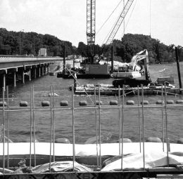
process once work on the southbound span was complete. IDOT required motorists traveling through the work zone to reduce their speed from 55 mph to 45 mph when construction activities were in progress. Figure 1, taken from the IDOT website, shows the location of the work zone and the DMSs (see DMS symbols) that were part of the ITS deployment.
 Figure 1 – Lake Springfield Bridge Reconstruction Project
Back to Top
System Design, Selection, and Implementation
This section provides information on IDOT's experience in bringing
the system from the concept stage to fully operational.
In-House or Contractor Design
- The approach that IDOT staff took represented a hybrid solution
to the question of developing a design for the system in house or
relying solely on contractors for the design. IDOT staff developed
detailed functional requirements for the system and then reviewed
the approach proposed by the vendor against the functional
requirements. IDOT then worked with the vendor to finalize the
system design. The functional requirements that IDOT developed for
the Lake Springfield Bridge work zone were largely inspired by other
traveler information systems that had been implemented in the state.
- Key IDOT functional requirements for the system included:
- Acquiring and processing traffic data, such as traffic speeds in all
kinds of weather/visibility conditions, and automatically selecting
motorist information messages for display on DMSs without
human intervention, while allowing for manual adjustment of
thresholds for advisory message selection or staff notification
- Displaying independent advisory messages on each DMS based on
conditions near specific DMSs
- Operating continuously (24/7) for the duration of the project
- Allowing IDOT staff to manually override motorist information
messages for a user-specified time, after which the system returned
to automated function
- Protecting critical functions with a password system
- Providing current traffic condition information via the Internet on
a full-color map that utilized color-coding to depict traffic conditions
- Archiving camera imagery
- At a central location, displaying sensor data and imagery for
locations equipped with sensors and CCTV.
System Selection and Procurement
- IDOT prepared functional requirements for a system to be used in
the work zone. IDOT then secured use of the system by including the
requirements as a bid item within the overall construction contract.
- The prime construction contractor for the project was responsible
for procuring a system that met IDOT's requirements. The prime
contractor used the IDOT requirements to select a vendor, United
Rentals, Inc., to provide the system. Following selection, IDOT
worked with the vendor to further refine and approve the proposed
system prior to deployment.
- The decisive factor in IDOT's approval of the vendor and system
proposed by the prime construction contractor was IDOT's familiarity
with similar systems that the proposed vendor had implemented in
other areas of the state (such as Chicago) that required significant
traveler information efforts due to traffic congestion.
Lease Versus Purchase
- The prime construction contractor leased the system from a firm
specializing in work zone systems. While IDOT did not technically
lease the system, the result was essentially the same because they
did not actually purchase the system to own (nor did the prime
contractor, which leased it from a firm specializing in work zone
systems).
- According to IDOT, procuring use of the system as a bid item rather
than purchasing the system for this project resulted in significant cost
savings. The cost of leasing the system was $785,000, representing
approximately 2 percent of the total project cost of nearly $35 million.
System Implementation
- Implementation of the RTTCS was a collaborative effort involving
IDOT and the vendor providing the system. The vendor initially
provided a draft implementation/configuration plan to IDOT that
was based on the vendor's previous experience as well as unique
characteristics of the Lake Springfield Reconstruction project. IDOT
staff then reviewed and revised the implementation plan. Revisions
were required in part, due to differences in interpreting certain
terms used by the vendor's software engineers and IDOT's traffic
engineers.
- Implementation required system calibration that was complicated
by the absence of significant traffic congestion. Consequently, the
initial deployment phase lasted longer than anticipated.
Testing
- Vendor and IDOT staff tested components prior to the system
coming fully online. In addition, traffic detectors were calibrated in
the work zone prior to system acceptance.
- IDOT required that the system be deployed on I-55 and tested two
weeks prior to initiation of reconstruction activities. The only
"difficulty" encountered was that there was no significant
congestion prior to the start of the reconstruction project, which
prevented complete calibration of the traffic detection system.
Consequently, recalibration of the system was required after the
work zone was in place.
- Terms in the contract agreement specified fines that would be
deducted from the fees IDOT would pay if system components did
not function properly. This arrangement served as motivation for the
contractor to keep the system up and running.
Training
- Use of an automated system and on-call vendor staff resulted in
minimal training requirements for IDOT staff.
Back to Top
System Description and Operations
System Description
- The RTTCS provided the state with a highly portable system
consisting of 17 remotely controlled portable DMSs, eight portable
traffic sensors, and four portable CCTV cameras. All components
were electronically linked to a central base station using wireless
communications. A DMS and traffic sensor are shown in Figure 2.
- The roadside systems operated from batteries that could be
recharged using small solar arrays. The RTTCS used a wireless modem
system that enhanced deployment options of the system. These
features make the RTTCS system a good candidate for rural or other
applications where utilities are not available or in large work zones
characterized by frequent changes in roadway alignments.
- The system's traffic sensors provided congestion information by
detecting the speed and presence of vehicles as they passed the
sensor stations. The central processor automatically generated
predefined messages that were displayed on DMSs upstream from
the sensor location and updated the traffic condition map on the
project website.
- CCTV imagery was used to confirm data generated by the system,
especially if the system detected an incident.
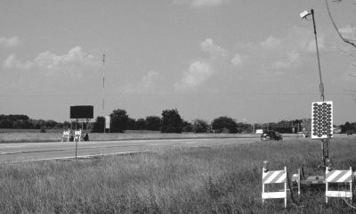 Figure 2 – Some of the I-55 System Components: DMS, and Traffic Sensor
with Solar Array
Figure 2 – Some of the I-55 System Components: DMS, and Traffic Sensor
with Solar Array
System Operations
- The RTTCS consisted of data collection devices electronically linked
via wireless communications to a central base station server. The
base station server processed data collected by system sensors and
calculated delay at each sensor station. The system then disseminated
appropriate information to travelers and IDOT staff. A concept of
operations diagram for the system is shown in Figure 3.
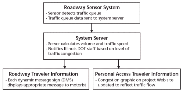 Figure 3 – Springfield Work Zone ITS Concept of Operations Diagram
- IDOT staff was automatically updated via email or pager based on
predefined thresholds established by IDOT. Thresholds were based
on length of delay and divided into 15-minute increments. The
system would contact higher-level IDOT staff as longer delays were
detected.
- Motorists received real-time traffic condition information, such as
delay warnings, via the system's 17 DMSs that were updated
automatically by the system. The system automatically displayed
preprogrammed messages based on real-time traffic conditions.
The DMSs displayed a variety of messages, including delay
information and lane closure advisories. DMSs were typically placed
upstream of highway junctions approaching the work zone as well
as within the work zone itself.
- The system integrated information and imagery for display on IDOT's
website to facilitate pre-trip planning. The system updated the website
every five minutes based on congestion levels in the work zone.
- Visitors to the website could read the message displayed on a
specific DMS by scrolling over it with their mouse.
- The vendor provided staffing for the system. This arrangement
typically entailed one person for periodic system performance
reviews and to be on call in the event of any problems occurring
after normal business hours.
Contractor or Agency Staff
- The vendor was responsible for providing 24-hour maintenance
support for the RTTCS seven days a week.
- The system's ability to function autonomously eliminated the need
for dedicated IDOT staff.
Coordination with Key Personnel, Other Agencies, and the Public
- IDOT took a proactive traffic incident management approach.
IDOT staff developed a Crisis Communication Plan that delineated
coordination procedures to be followed for various types of
incidents. The RTTCS was an integral part of the coordination
process. The system paged or sent alerts to designated key personnel
and displayed preprogrammed messages for travelers based on
the extent of traffic delays.
Maintenance
- By acquiring use of the system as a bid-line item, IDOT procured the
services it needed without purchasing the equipment and placed
maintenance responsibilities on the vendor.
- Terms and conditions in the bid agreement specified fines for system
deficiencies that the vendor did not correct within a specified time.
This encouraged the vendor to maintain a high level of system
readiness.
- IDOT's contract required the vendor to "dispatch sufficient resources
within two hours of notification (of a deficiency) to make needed
corrections of deficiencies." The contract also stipulated that all
deficiencies had to be corrected within 12 hours.
- IDOT required the vendor to have staff available on a 24-hour-a-day
basis to respond to IDOT regarding RTTCS performance.
Back to Top
Results
System Performance
- The system successfully monitored traffic along a busy interstate
between Springfield (the state capital) and St. Louis, the location of
a busy airport serving southern Illinois and eastern Missouri. IDOT
reported that the system performed well, with little downtime.
- IDOT staff said that they would use the system again.
System Input and Output to the Public
- Input – The system's eight portable traffic detectors used X-Band
radar to automatically collect vehicle speed and presence data.
The system used four portable CCTV cameras to identify possible
incidents detected by the traffic detectors (e.g., if the system
detected traffic stopped for long periods of time) or to confirm
traffic conditions "when system data was ambiguous."
- Output – Real-time traveler information was disseminated to
motorists via portable DMSs. Information included delay information
and lane closure advisories. IDOT also maintained a project
website where those not yet enroute could access a map of the
area showing real-time congestion levels in and approaching
the work zone. An image from the website is shown in Figure 4.
The lightly shaded area along I-55 in the figure shows that traffic
is at free-flow speeds on both approaches to the work areas at the
time the screenshot was captured. By scrolling over individual DMSs
shown on the website map, users could access the message currently
displayed on the DMS at that location. The website also
provided real-time imagery from the system's CCTV cameras.
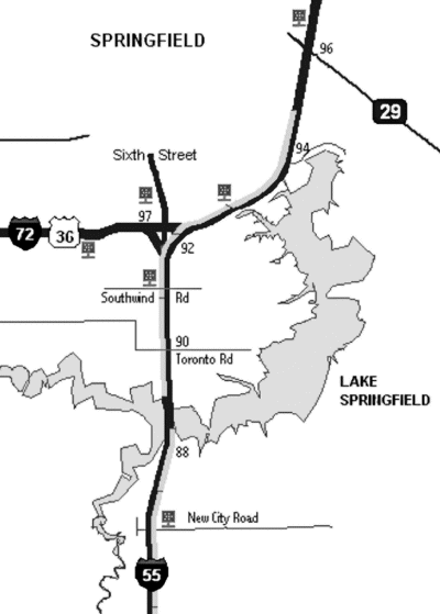 Figure 4 – Screen Capture from Project Website
System Evaluation
- Overall, IDOT officials were satisfied with the performance of the
RTTCS, though no official evaluation of the system was performed.
IDOT was using similar systems at two other work zone sites at the
time this case study was prepared.
- The system appeared to be effective given the absence of severe
congestion in the work zone. IDOT attributed this lack of
congestion to the absence of major incidents and to a reduction in
ticket-writing activities that frequently cause traffic delays due to
rubbernecking by drivers passing the scene.
Benefits/Impacts
IDOT staff identified several major benefit areas for the RTTCS, which
are listed below.
Mobility
- IDOT staff reported no significant traffic backups while the RTTCS
was in place, despite the work zone's location on a busy interstate
between the Illinois state capital and the nearest airport, Lambert -
St. Louis International Airport, in St. Louis. Daily traffic on the I-55
approaches to the bridge averaged approximately 41,000 vehicles
per day.
Safety
- IDOT staff responsible for operations in the Lake Springfield work
zone reported only two crashes in the construction area during the
implementation of the RTTCS. One of the crashes was attributed to
driver fatigue and the other to driving while impaired. IDOT staff
attributed the small number of crashes to the absence of backups
and to the ample warning drivers received via DMSs (as shown in
Figure 5), some of which were located 40 miles upstream of the
work zone.
- RTTCS DMSs notified drivers as they approached the work zone area
of the number of citations that had been issued in the work zone.
IDOT staff reported a significant downward trend in the number of
violations after the system began displaying these messages.
Cost Savings
- The RTTCS automatically alerted the appropriate personnel only
when human intervention was required, eliminating the need to
have staff constantly monitor CCTV displays or patrol the work zone.
The system sent automatic alerts based on thresholds defined by
IDOT and preprogrammed into the RTTCS.
- IDOT avoided large capital costs by securing use of the system only
for the duration of the project, thereby avoiding the purchase of
major hardware components of the RTTCS. Operating costs were
minimized by a system design that focused on automation.
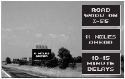 Figure 5 – DMSs Alerted Drivers to Traffic Conditions in the I-55 Work Zone
(Figure Shows an Example 3-Phase Message)
Public Reception/Reaction to the System
- IDOT did not receive significant public reaction to the system
(positive or negative). The project website recorded 2,400 hits during
the course of the project, which is greater than the amount of traffic
typically received by IDOT construction project websites.
Obstacles Encountered and Lessons Learned
Planning and System Development
- Relating with Other Agencies: It is important to involve agencies
responsible for 911 and other emergency response operations during
system planning and design. This effort can help facilitate a
coordinated response to incidents during the roadwork.
- Relating with the Public: It is important to use a proactive approach
to building public awareness of the project. Successful techniques
include holding press conferences, issuing news releases, and
keeping local media up to date.
- System Selection: It is important to assess when it is appropriate to
use a work zone ITS application and what type of system best meets
the site-specific needs.
- System Features/Capabilities: During the requirements definition
process, it is important to ensure that software/systems engineers
and transportation engineers use common terminology.
- System Features/Capabilities: Including the vendor's engineering
staff, in addition to vendor marketing staff, in early discussions of
vendor capabilities is important.
System Deployment
- Start-Up: It is necessary to allow significant time for system
calibration during initial implementation of queue-length detection
systems. The calibration process will likely take longer than the best
estimate of the time required.
- Deployment Constraints: The primary constraint on the system as
configured for the Lake Springfield Bridge Reconstruction project
was the requirement for cellular digital packet data (CDPD) coverage
in the work zone area and between the work zone area and the
central communications center. Given current plans by the wireless
industry to phase out CDPD service in the summer of 2004, it should
be noted that there are an increasing number of inexpensive
communications products becoming available that can operate in
the 2.4 GHz frequency range and support systems such as the RTTCS.
System Operations
- Calibration: Agencies should expect to need to recalibrate detection
systems during the course of the project.
Back to Top
Conclusion
" The Illinois Department of Transportation will continue to implement cutting-edge technologies and approaches such as those in use in the Lake Springfield construction area to ensure that the traveling public has the most up-to-date information possible when making travel decisions."
— James Slifer, Illinois Director of Highways during the Lake Springfield Bridge reconstruction project
IDOT staff reported a high level of satisfaction with the RTTCS
deployed in the I-55 work zone. The system provided important
traveler information for those traveling or planning trips through the
area with minimal human intervention or downtime. Any downtime
experienced by the system was typically attributed to the need
to recalibrate the system following movement of traffic sensors.
In addition, IDOT staff believes that the system also provided safety
benefits based on the decreased number of moving violations after
deployment and the small number of crashes that occurred in the
work zone. The system also enhanced IDOT incident detection in the
work zone, though this was not the main goal or function of the
system. IDOT was using similar systems at two other work zones at the
time this case study was prepared.
Illinois DOT contact for this deployment:
William Frey
217-782-7401
FreyWR@dot.il.gov
Back to Top
Federal Highway Administration Resource Center Locations
Baltimore, MD
10 S. Howard Street
Suite 4000
Baltimore, MD 21201
Phone 410-962-0093
Atlanta, GA
61 Forsyth Street, SW
Suite 17T26
Atlanta, GA 30303-3104
Phone 404-562-3570
Olympia Fields, IL
19900 Governors Highway
Suite 301
Olympia Fields, IL 60461-1021
Phone 708-283-3500
San Francisco, CA
201 Mission Street
Suite 2100
San Francisco, CA 94105
Phone 415-744-3102
FHWA Metropolitan Offices
New York Metropolitan Office
1 Bowling Green
Room 428
New York, NY 10004-1415
Phone 212-668-2201
Philadelphia Metropolitan Office
1760 Market Street
Suite 510
Philadelphia, PA 19103-4124
Phone 215-656-7070
Chicago Metropolitan Office
200 West Adams Street
Suite 2410
Chicago, IL 60606-5232
Phone 312-886-1616
Los Angeles Metropolitan Office
201 North Figueroa
Suite 1460
Los Angeles, CA 90012
Phone 213-202-3950
Back to Top
This Document Is One in a Series of Products That Address ITS Issues Pertinent to a Variety of Audiences
- Elected and Appointed Officials
- Senior Decision Makers
- Transportation Managers
- Technical Experts
Representing:
- States
- Cities
- Counties
- Transit Properties
- Toll Authorities
- Emergency Service Providers
- Metropolitan Planning Organizations
- Additional Transportation Stakeholders
ITS Topics Addressed in This Series:
- Commercial Vehicle Operations
- Emergency Services
- Enabling Technologies
- Emissions Management
- Freeway and Arterial Management
- Highway Operations and Maintenance
- Planning and Integration
- Real-Time Traveler Information
- Transit, Toll, and Traveler Information
- Weather Information for Travelers and Maintenance
- Work Zones
For a current listing of available documents, please visit our website at:
http://www.its.dot.gov
Intelligent Transportation Systems

U.S. Department of Transportation
400 7th Street SW
Washington, DC 20590
Federal Highway Administration
Room 3416, HOIT-01
Phone: 866-367-7487
Facsimile: 202-493-2027
FHWA-HOP-04-018
EDL# 13984
|
|
