Appendix C: Exercises
The data used in these exercises are fictitious and are for demonstration purposes only.
Module 3—Exercise
Project Coordination
A transportation agency is planning several road projects. These projects include significant infrastructure improvements in close proximity (within 1 square mile) to each other. The projects were designed at different times, as noted below, but lack of funding delayed construction. The DOT now has programmed funding to undertake all projects in fall 2013.
The main corridor is a 6-lane arterial with an ADT of 65,000 vehicles; approximately 60% is commuter traffic.
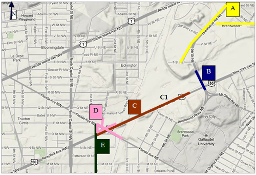
The projects (see figure above) in the vicinity include (design dates in parenthesis):
- Project A (2010): Resurface/Rehabilitate Brentwood Road
- Project B (2010): Replace Bridge over New York Avenue
- Project C (2008): Reconstruct the New York Avenue including bridge (C1)
- Project D (2008): Traffic Safety Improvement Project at intersection
- Project E (2006): Reconstruction of 1st Street
Questions
- As the Project Engineer for one of the five construction projects, identify some key issues that could arise if all projects start together, as planned for fall 2013?
- What are some possible ways to handle coordination?
Module 4—Exercise
Corridor Rehabilitation
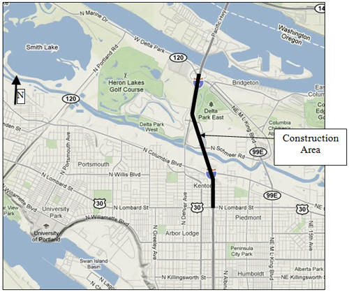
A transportation agency is planning to rehabilitate an approximately 0.81-mile section (southbound only) of the I-5 Freeway from W. Delta Park to N. Lombard Street (see figure below). I-5 is a designated north - south major freight route, within the Functional Classification of Urban Principal Arterial – Interstate. I-5 currently has three northbound travel lanes and two southbound travel lanes through the project area. This section of Pacific Highway (I-5) is access controlled and has local street/highway access only through the freeway on-off ramp system.
The two-lane southbound section creates a traffic bottleneck that results in congestion and safety problems. This section of I-5 also has substandard shoulders, medians, and acceleration lanes. The proposed improvements (southbound only) would provide a three-lane section for southbound direction with standard shoulders, median, and acceleration lanes. Traffic volumes along the I-5 corridor in the vicinity of the project are over capacity with 55,000 ADT per day in the southbound direction. Heavy vehicles account for 7% of the traffic.
Questions
- What are work zone traffic control alternatives that you would consider for the project?
- What are some of the factors to be considered while choosing the alternative?
- Do you have enough data to make a decision about a traffic control alternative? If not, what other data would you need?
Module 5—Exercise
Bridge Replacement
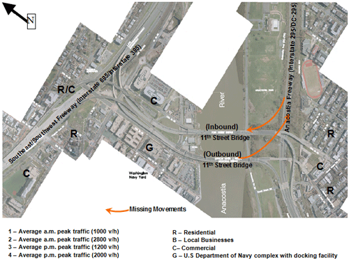
The 11th Street Bridges are a pair of one-way bridges across the Anacostia River in a major urban area. The bridges currently provide a connection from the Anacostia Freeway (I-295/DC-295) to the Southeast/Southwest Freeway (I-695/I-395); however, there is no direct connection between the Southeast Freeway and the northern segment of the Anacostia Freeway (see figure below). Because of this unfinished connection, regional commuting traffic from surrounding jurisdictions is forced to use neighborhood streets to reach the Anacostia Freeway to and from the Southeast Freeway. This causes significantly increased traffic on local streets.
The 11th Street Bridge reconstruction project is a Design-Build Project intended to replace this aging pair of Anacostia River bridges and to construct the missing connection The project will also add a third bridge dedicated to local traffic, which will accommodate bicyclists and pedestrians along with streetcar tracks for improved transit accommodations. It is anticipated that during any one day of the construction as many as 10-15 different lane closures will be operational within the construction limits.
Questions
- Identify some of the public relations issues that the D/B contractor will need to address during design and construction. What are some TMP strategies that could be used for public outreach?
- Cite some of the operational issues the contractor will need to address during lane closures. What strategies may be useful to address these operational issues?
Module 6—Exercise
A transportation agency is reconstructing a major bridge at mile marker 104 on I-95. I-95 runs north-south and has three lanes in each direction at this location. While some work will be completed outside of existing roadway limits with no impact to road users, other portions of the work will require temporary restrictions of traffic, including lane closures, shoulder closures, and lane shifts. During the morning peak condition (6:30 a.m. to 9:30 a.m.) the average hourly lane volume is 1300 vph for the southbound direction. The off peak hourly volume is 400 vph. There is no p.m. peak in the southbound direction. In the northbound direction the evening peak period is 3:30 p.m. to 6:30 p.m. with an average hourly lane volume of 1450 vph. The northbound off peak hourly volume is 400 vph. The construction is expected to be completed in 18 months.
Traffic impact assessment was conducted based on the following constraints:
- All lanes shall be kept open during the peak hour by direction
- At all other times at least two lanes must be kept open
- Lane closures are limited to 9:30 a.m. to 3:30 p.m. and 8:00 p.m. to 6:30 a.m., Monday through Friday.
- If the queue length extends 2.5 miles beyond the work zone or the travel time exceeds 30 minutes, contractor operations shall be adjusted to open all lanes until either the queue length reduces to 1.0 mile or the travel time to 10 minutes.
Based on this analysis, appropriate strategies (TTC, TO, and PI&O) were selected to mitigate the impacts. The construction activities are being done in accordance with contract requirements and the approved TMP is being implemented.
Questions
- Why is it important to monitor the TMP when this project is under construction?
- If the contact or proposes to accelerate the construction schedule via additional lane closures and/or extension of lane closure hours:
- How might this affect the TMP?
- Who should be involved in reviewing and approving the changes?
General Exercise
A transportation agency is planning several projects in a heavily developed urban area; one scenario is presented here for discussion. As part of the project, the agency is reconstructing the bridge over New York Avenue. New York Avenue is a major principal arterial with three lanes in each direction, and is a designated emergency route. The transportation agency has determined that this is a significant project with major anticipated impacts.
Construction Conditions New York Avenue:
- Average weekday volume—65,000 vpd (a.m. split 75/25).
- Posted speed limit—35 mph.
- Truck Percentage—6%.
- Average weekday volume on (ramp)—52,000 vpd (split 75/25).
- 2 southwest bound New York Avenue lanes in a.m. peak hour (7:00–10:00 a.m.) (12-ft lanes).
- 3 northeast bound New York Avenue lanes in p.m. peak (3:30–6:30 p.m. (9-ft lanes).
- Close Ramp from SB 9th Street ramp to SWB New York Avenue.
- Implement Detour Plan—Traffic to continue on Brentwood Parkway and make a right on Penn Street to get to New York Avenue.
The agency used Synchro to analyze the existing conditions and the proposed construction conditions presented here. Following table summarizes the results.
| Intersection (Cross Street, signalized) |
New York Ave. (SWB a.m.) | New York Ave. (NEB p.m.) | ||||||
|---|---|---|---|---|---|---|---|---|
| Existing/Baseline | Construction | Existing/Baseline | Construction | |||||
| Queue (ft) | LOS | Queue (ft) | LOS | Queue (ft) | LOS | Queue (ft) | LOS | |
| Florida Avenue | 1243 | E | 2190 | F | 450 | C | 400 | D |
| Penn Street | 167 | C | 631 | F | 125 | C | 225 | D |
| Fairview Avenue | 150 | C | 550 | F | 115 | C | 125 | D |
| Bladensburg Road | 1166 | E | 2005 | F | 350 | C | 425 | D |
| Notes: SWB—Southwest bound; NEB—Northeast bound | ||||||||
| Corridor Extent New York Avenue from Bladensburg Road to Florida Avenue |
New York Ave. (a.m. peak) | |
|---|---|---|
| SWB | NEB | |
| Travel time (min) | ||
| Baseline | 18.5 | 7.5 |
| Construction | 38.0 | 9.2 |
A map of the construction area (figure 1) is shown below.

Figure 1: Construction Area Map
Questions
- The construction scenario presented above is estimated to have significant delays during the morning peak (SWB). What are possible strategies to implement to manage the impacts?
- A major crash occurs on New York Avenue SWB at 6:00 a.m. (see figure 2 below). All SWB lanes are closed and not expected to reopen until 9:00 a.m. What are possible strategies that need to be in place to manage the impacts?

Figure 2: Crash Location
A sample work zone management strategies checklist is provided below.
Work Zone Management Strategies Tool Box
1. Temporary Traffic Control
| 1.1 Control Strategies | |
|---|---|
| Construction phasing/staging | |
| Full roadway closures | |
| Lane shifts or closures | |
| One-lane, two-way controlled operation | |
| Two-way, one-lane traffic/Reversible lanes | |
| Ramp closures/relocation | |
| Freeway-to-freeway interchange closures | |
| Night work | |
| Weekend work | |
| Work hour restrictions for peak travel | |
| Pedestrian/Bicyclist access improvements | |
| Business access improvements | |
| Off-site detours/use of alternate routes |
| 1.2 Traffic Control Devices | |
|---|---|
| Temporary signs | |
| Portable changeable message signs (PCMS) | |
| Arrow boards | |
| Channelizing devices | |
| Temporary pavement markings | |
| Flaggers and uniformed traffic control officers | |
| Temporary traffic signals | |
| Lighting devices |
| 1.3 Project Coordination Strategies | |
|---|---|
| Other area projects | |
| Utilities | |
| Right-of-Way | |
| Other transportation infrastructure |
| 1.4 Innovative Contracting Strategies | |
|---|---|
| Design-build | |
| ALB Bidding | |
| Incentive/Disincentive clauses | |
| Lane rental | |
| Performance specifications |
| 1.5 Innovative or Accelerated Construction Techniques | |
|---|---|
| Prefabricated/recast elements | |
| Rapid cure materials |
2. Transportation Operations
| 2.1 Demand Management Strategies | |
|---|---|
| Transit service improvements | |
| Transit incentives | |
| Shuttle services | |
| Parking supply management | |
| Variable work hours | |
| Telecommuting | |
| Ridesharing/carpooling incentives | |
| Park-and-Ride promotion |
| 2.2 Corridor/Network Management Strategies | |
|---|---|
| Signal timing/coordination improvements | |
| Temporary traffic signals | |
| Street/intersection improvements | |
| Bus turnouts | |
| Turn restrictions | |
| Parking restrictions | |
| Truck/heavy vehicle restrictions | |
| Reversible lanes | |
| Dynamic lane closure system | |
| Ramp closures | |
| Railroad crossing controls | |
| Coordination with adjacent construction site(s) |
| 2.3 Work Zone ITS Strategies | |
|---|---|
| Late lane merge | |
| PCMS with speed display | |
| Travel time estimation system | |
| Advanced speed information system | |
| Advanced congestion warning system | |
| Conflict warning system (e.g., construction vehicles entering roadway) | |
| Travel time monitor system | |
| Freeway queue monitor system | |
| CCTV monitoring | |
| Real-time detour |
| 2.4 Work Zone Safety Management Strategies | |
|---|---|
| Speed limit reduction/variable speed limits | |
| Temporary traffic signals | |
| Temporary traffic barrier | |
| Movable traffic barrier systems | |
| Crash-cushions | |
| Temporary rumble strips | |
| Intrusion alarms | |
| Warning lights | |
| Automated flagger assistance devices (AFADs) | |
| Project task force/committee | |
| Construction safety supervisors/inspectors | |
| Road safety audits | |
| TMP monitor/inspection team |
| 2.5 Incident Management (ICM) and Enforcement Strategies | |
|---|---|
| ITS for traffic monitoring/management | |
| TMC | |
| Surveillance (e.g., CCTV) | |
| Helicopter for aerial surveillance | |
| Traffic Screens | |
| Call boxes | |
| Mile-post markers | |
| Tow/freeway service patrol | |
| Total station units | |
| Photogrammetry | |
| Media coordination | |
| Local detour routes | |
| Contract support for ICM | |
| Incident/Emergency management coordination | |
| Incident/Emergency response plan | |
| Dedicated (paid) police enforcement | |
| Cooperative police enforcement | |
| Automated enforcement | |
| Increased penalties for work zone violations | |
| Emergency pull-offs |
3. Public Information and Outreach
| 3.1 Public Awareness Strategies | |
|---|---|
| Branding | |
| Press kits | |
| Brochures and mailers | |
| Press releases/media alerts | |
| Mass media (earned and/or paid) | |
| Paid advertisements | |
| Project information center | |
| Telephone hotline | |
| Planned lane closure website | |
| Project website | |
| Public meetings/hearings, workshops | |
| Community task forces | |
| Coordination with media/schools/business/FEMS | |
| Work zone education and safety campaigns | |
| Rideshare promotions | |
| Visual information |
| 3.2 Motorist Information Strategies | |
|---|---|
| Radio traffic news | |
| Changeable message signs | |
| Temporary motorist information signs | |
| Dynamic speed message sign | |
| Highway Advisory Radio (HAR) | |
| Extinguishable signs | |
| Highway information network (web-based) | |
| Traveler information systems (wireless, handheld) | |
| Transportation Management Center (TMC) | |
| Live traffic camera(s) on a website | |
| Project information hotline | |
| Email alerts |