DC-295 in Washington, DC
Work Zone and System Description
In 2006, the District of Columbia Department of Transportation (DDOT) deployed an ITS system on Highway 295 in Washington, DC. The system covered an approximately 7 mile stretch of DC-295, with some components on adjacent routes. DDOT designed and procured the system to help alleviate congestion and provide real-time information to motorists in the field and via a website. DDOT's main goals for the ITS system were to monitor conditions and improve mobility and safety through the work zone by managing traffic during lane closures due to their potential to produce abnormally large traffic backups and create potential for crashes outside the work zone. The location and system layout are shown in Figure 2.
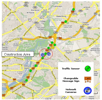
Figure 2. DC-295 Work Zone Area and ITS Layout
Based on predetermined delay and speed thresholds, the system provided real-time delay and speed information and, as needed, recommended alternate routes via dynamic message signs (DMS) for high congestion periods.
DDOT incorporated a special provision for the Real-Time Work Zone System (RTWS) for both the northbound and southbound directions of Kenilworth Avenue (DC-295) from Foote Street to Lane Place Bridge over Nannie Helen Burroughs Avenue, in northeast Washington, DC. DDOT procured the system through an existing contract with the design consultant.
Kenilworth Avenue is a barrier separated, six-lane freeway and serves as a major highway link between other major routes within the District of Columbia, including I-395, I-295, and the Baltimore-Washington Parkway. DC-295 is a heavily traveled commuter route, carrying over 100,000 vehicles daily between Maryland and Washington, DC.
Focus of the Evaluation
The main objectives of the system were to:
- Reduce work zone-related congestion through a heavily traveled urban corridor.
- Provide delay and speed information to warn motorists of slowed traffic ahead and encourage diversion (when significant delays occurred).
- Provide information to commuters for trip planning and to DOT personnel for condition and system monitoring via a website.
- Build public confidence in real-time traveler information.
The study team focused on queue lengths and diversion rates for this site. Since the system detectors covered a large area along DC-295, the study team used only archived system data in the analysis and did not find a need to place supplemental detectors to archive additional data.
The study team began the analysis by sorting traffic data from system detectors for preliminary inspection to determine the potential for use in the analysis. The archived traffic data consisted of more than one million records covering a time period from November 1, 2006 through August 15, 2007.
Findings
The study team calculated queues using detector spacing for time periods where speeds dropped below 30 miles per hour. The calculated queues were much longer (often more than five times longer) than those documented by construction managers as queues that were caused directly by the lane closures. Due to the large difference between estimated and observed queue lengths on nearly all of the data collection days (based on mostly recurring congestion and not congestion caused by the work zone), the analysis of queues before and after implementation proved inconclusive.
The study team also evaluated demand patterns to test diversion when the system activated. The results showed that the volume levels changed significantly when the system posted delay information and recommended that motorists seek an alternate route to southbound DC-295. During one time period, the system observed as much as 90 percent less volume during system activation.
Overall, the data showed 3 to 90 percent lower observed mainline volumes compared with similar days of the week (with an average of 52 percent reduction) by warning motorists prior to entering the mainline. These results are based on nine observation periods where delays were significant enough for the system to recommend alternate routes. For about two thirds of the data collection period, the system collected baseline data, but did not provide messages to drivers. During the portion of the data collection period where the system was "on" and providing messages to drivers, there were limited observations where the system recommended alternates.
It should be noted that the results include potential reduced throughput due to queues and congested conditions (likely significant for the higher end of the range). However, even considering the congestion impacts on throughput, these results show that the system likely reduced delay substantially for motorists by providing them with information to better enable them to choose an alternate route. It should also be noted that this is an urban area with a large number of commuter trips. Based on the data available, it is not possible to determine what portion of the lower mainline volume was due to diversion versus demand reduction versus congestion.
Tips and Lessons Learned
Flexibility in system configuration is important. DDOT successfully modified the original system layout to account for impacts from a separate construction project in a neighboring state.
Allow time for obtaining right of way use permits for equipment installation. The vendor used by DDOT noted that time was required to get approval of these permits before they could place the equipment in the field.
Secondary benefits of managing recurring congestion along heavily traveled urban corridors also may be achieved. DDOT successfully used the system to manage recurring congestion along the heavily traveled DC-295 corridor.
| Key Finding: The real-time information system appeared to effectively divert traffic to unsigned, unspecified alternate routes during times of significant congestion. There was an average of 52% lower mainline volume observed (combination of diversion, demand reduction, and congestion). |
Previous | Next