Road User Benefits through Accelerated Construction
slide 1: Road User Benefits through Accelerated Construction
MassDOT I-93 Fast14 Project
FHWA Webinar
May 30, 2013
Download the Printable Version [PDF,
5.2 MB]
You may need the Adobe® Reader® to view this PDF.
slide notes:
None
slide 2: Project Overview
- Fast 14 I-93 Rapid Bridge Replacement Project
slide notes:
None
slide 3: Birth of a Project
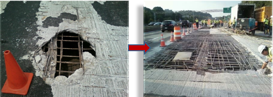
- Interstate 93 bridge superstructures in Medford are more than 50 years old and need to be replaced
- An on-going MassDOT repaving project during the spring/summer of 2010 revealed advanced deterioration in northbound bridge decks
- In July 2010 MassDOT initiated a feasibility study to replace the superstructures for several bridges on Intersection 93
- Deck failure in August 2010 on I-93 over Valley Street significantly reduced road capacity during completion of emergency repairs
slide notes:
A scheduled highway resurfacing project, started in 2008, exposed severely deteriorated bridge decks
Valley St failure underscored need for deck replacement project for entire corridor
Feasibility Study started in July 2010 to compare conventional construction with various concepts to accelerate construction
Traffic volumes preclude long term closures
Decision made, FIX THEM ALL NEXT SUMMER
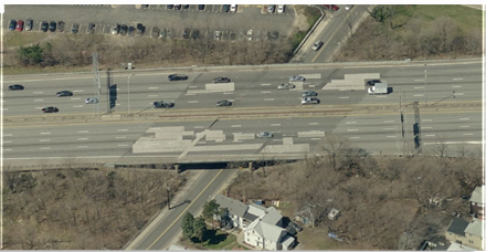
slide 4: Isolated failures can result in full span repairs
Isolated failures can result in full span repairs
Delaying commencement or completion of replacements may result in unscheduled emergency repairs
slide notes:
The concrete decks are in poor condition with deteriorated concrete. In addition, the steel beams that support the deck are corroded and are painted with lead paint. Fortunately, the substructures (foundations and piers) are in good condition, needing only minor repairs.
slide 5: Bridge Locations
slide notes:
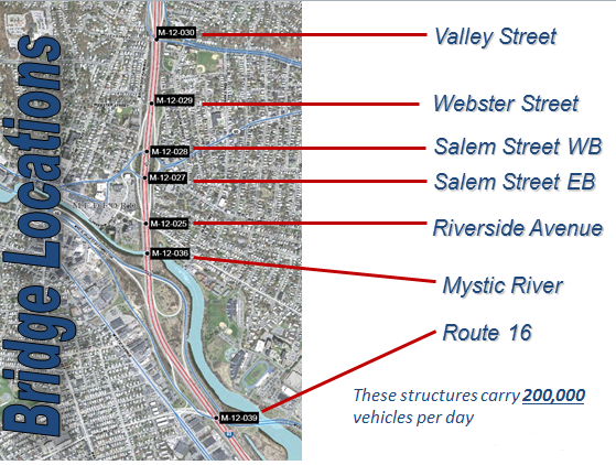
The 14 bridges are located wholly within the City of Medford, Massachusetts, just 3 miles north of Boston.
All of the bridges are located between 3 closely spaced Interchanges with only a half to one mile between consecutive interchanges
The bridges carrying the northbound and southbound travel lanes of I-93 are is structurally independent of one another, thus, it is possible to travel on one bridge structure while demolishing and reconstructing the other.
slide 6: Conventional Construction
- Requires 5 stages
- Minimum 4 years
- Increased congestion/delays
- Worker safety issues
- Unsafe traffic splits
- Narrow travel lanes
- Loss of accel/decel lanes
- Concern over durability of the existing decks
slide notes:
Our Feasibility Study examined conventional construction and found there to be some key disadvantages to this methodology:
- Due to the geometric constraints on the roadway we would have needed 5 Stages of construction spread over at least 4 years
- The limited shoulder area we do have would be used for a travel lane that in some cases would be less than our standard 12-feet
- This would take away what we do have for accel/decel lanes and lead to increased congestion / travel delays during the peak periods
- History has taught us that an isolated minor crash along this corridor creates congestion and quickly leads to diversion to the secondary routes and locally owned roadways
- We would also be forced to run split traffic between the center work zone which historically presents safety concerns
- The overall tight cross-section would put the workers an a condition of greater risk
- Finally, due to the aforementioned condition of the bridge decks, there was concern over delaying much needed replacement for too long
slide 7: Accelerated Construction
- Replace 14 deteriorated bridge superstructures over 10 weekends in June, July, August
- No Work on July 4th
- 2-weekends of float for weather/construction issues
- Use crossover on I-93 to provide 2 lanes NB and SB over weekend
- Aggressive traffic management
slide notes:
I will go into more detail later, but the concept that our team of DOT decision makers and our experienced consultant engineers came up with was the epitome of "accelerated construction" with a schedule to replace 14 full bridge superstructures in just 10, 55-hour weekends.
- We set the schedule to avoid the 4th of July holiday which is a busy tourism period for the Boston region
- We provided for 2-weekends of float that would allow the Design-Build Contractor to cancel under a severe weather forecast or construction material issue
- The TMP called for use of a cross-over to maintain 2 lanes in each direction on one-barrel of the interstate and closing the other
- We developed a very aggressive traffic management plan that was necessitated by the lack of options for regional detours
slide 8: Initial Project Goals
- Use of Accelerated Bridge Construction to reduce the duration of construction
- Make work zone safety is a priority
- Minimize traffic impacts to motorists and local communities
- Stress need to encourage route diversion
- Effectively communicate travel delays and detour routes to the public at large
- Sell the overall benefits of ABC
slide notes:
So what did we set for our initial project goals:
- After some investigation our structural engineers decided that pre-fabricated bridge elements was the way to go. We further decided to use composite deck and beam sections to allow for rapid reconstruction of the superstructure
- All elements of the TMP and site specific Temporary Traffic Control Plans were based on safety-first priority. There may have been opportunities to do things easier we could not risk an incident to blow the schedule
- Minimizing traffic impacts to our Interstate customers and the regional movement in the municipalities was very important
- We knew early on that we had to have traffic diversions to get this to work, and the only way to do that was effective public outreach using any-and-all mediums
- Finally, trust in DOT for this type of work was lacking and we needed to sell the benefits of ABC to get-in and get-out and stay-out.
slide 9: Existing Traffic Volumes
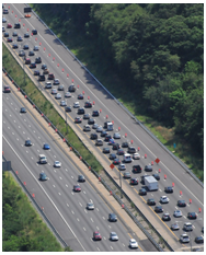
- Evaluated historical I-93 summer count data to determine the possible impact for dropping two lanes on a 4-lane interstate highway
- This section of I-93 carries between 169,000 and 181,000 vehicles per day, even weekends
- I-93 weekend volumes for the highest hours of the day are still around 5,500 vph NB and SB
- Route 28, the primary local detour route, carries between 700 to 1,800 vph on the weekend
- The primary detour route has 16 traffic signals under local or other State Agency control and need to evaluated and re-timed for progression
- Impacts expected on other regional facilities (Route 16, Route 38 & Route 60) which all see significant weekend peak hour traffic volumes
slide notes:
- We examined historical traffic volumes for this corridor that handles between 169 and 181-thousand vehicles a day, Even Weekends to find that we still were seeing about 5,500 veh/hr each direction during the peak hours.
- Our primary local access detour route carries 700 to 1,800 vehicles per hour along a four-lane divided roadway which is not too bad, but there are 16 signalized intersections along that route.
- MassDOT did not control the majority of the traffic signals along the detour route and had to inventory each of them to learn what we were dealing with
- Other regional highways were also heavily travelled during the weekend peak periods and would see significant impacts.
slide 10: Traffic Operations Goal
slide notes:
- Diversion is necessary to try and get the two-lane capacity close to the projection of 2,960 veh/hr capacity – otherwise we would have severe congestion
- Queuing and longer travel times were inevitable for the Interstate and would result in big impacts on the secondary routes
- GOAL is to reduce traffic during construction by encouraging motorists to divert to other regional highways (I-95, I-495, I-90, Rt. 1)
Avoid gridlock conditions at all costs!
slide 11: Traffic Diversion Goal
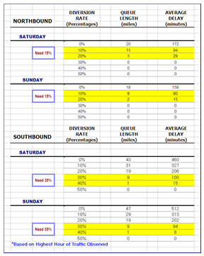
|
Need Minimum of 15% traffic diversion Northbound on I-93 Need Minimum of 35% traffic diversion Southbound on I-93 |
slide notes:
The long and short of things was that we identified a need to divert at least 15% of the NB traffic on both Saturday and Sunday peak hours
And,about 35% of the Southbound traffic during the weekend peak hours which is an extremely aggressive request
slide 12: Road User Cost Projections
This represents the cost of one hour of general purpose vehicle driver's travel time based on a 2011 forecast using Consumer Price Index (CPI) History
| TIME OF DAY | VALUE OF VEHICLE OPERATOR'S TIME ($ / HOUR) | DELAY TIME (HOURS) | VOLUME (VEHICLES / HOUR) | INCREMENTAL ROAD USER COST AT EACH 15 MINUTE INTERVAL | TOTAL ROAD USER COST AT EACH 15 MINUTE INTERVAL |
|---|---|---|---|---|---|
| Mon., 5:00:00 AM | $18.97 | 0.5 | 6,549 | $62,117 | $62,117 |
| Mon., 5:15:00 AM | $18.97 | 1.5 | 7,000 | $199,185 | $261,302 |
| Mon., 5:30:00 AM | $18.97 | 2.5 | 8,000 | $379,400 | $640,702 |
| Mon., 5:45:00 AM | $18.97 | 3.5 | 10,000 | $663,950 | $1,304,652 |
| Mon., 6:00:00 AM | $18.97 | 4.5 | 11,036 | $942,088 | $2,246,740 |
| Mon., 6:15:00 AM | $18.97 | 5.5 | 11,150 | $1,163,335 | $3,410,076 |
| Mon., 6:30:00 AM | $18.97 | 6.5 | 11,400 | $1,405,677 | $4,815,753 |
| Mon., 6:45:00 AM | $18.97 | 7.5 | 11,600 | $1,650,390 | $6,466,143 |
| Mon., 7:00:00 AM | $18.97 | 8.5 | 11,847 | $1,910,270 | $8,376,412 |
slide notes:
The following table documents the road-user costs based on the measured increase in traffic volumes on I-93 on Monday Morning
This data was used to develop the specific Incentive/Disincentive Program values carried in the contract RFP
The costs to the motor vehicle operator for each 15-minutes of delay after 5 AM Monday morning was calculated
slide 13: Incentives & Disincentives
Operator valued at $18.97 per person per hour with an average volume of 6,549 veh/hour = Incremental Road User costs at each 15-minute interval starts at $62,117
| The Road User Costs represent the disincentive values that could be charged against the contractor for being late by each 15-minute increment |
slide notes:
The Incentive/Disincentive Maximum Total Amount of $7M is based on 10% of the estimated project value of $70M.
The key was the payment for Milestone (MS) #1 = $6,450,000 which was the bridge construction component
Achieving Mile-Stone 1 is based on meeting the 5 AM opening on each weekend of bridge construction
The contractor would receive a disincentive if they failed to be fully off the roadway and all lanes opened by 5 AM
Each 15-minute increment after 5 AM would take more money from the potential large incentive if the roadway was opened on time
slide 14: So how do we do it?
slide notes:
None
slide 15: Traffic Management Details
- Provide full access to one barrel of I-93 and divert traffic from opposite side via a crossover
- Use movable barrier to provide counter-flow operation for 2 lanes each direction
- Divert regional trips away from I-93
- Focus on "safe" means for mobility
- Allow local use of I-93 where feasible to provide access to on/off-ramps
- Use Real-Time Traffic Management system
- Use Police Details to support traffic operations and follow ICS for quick clearance
slide notes:
- Deploy a two-lane crossover with movable barrier for the 4.5 counter-flow segment
- To Mitigate the need for diversion we planned out a large-scale Smart Work Zone System to provide travel times for the corridor
- A comprehensive signal progression plan, including controller upgrades was planned for the local detour route
- We worked directly with our Construction staff to find ways to ensure that highway safety was prioritized including allowing a local access lane providing ability to get/off ramps on the closed highway between the crossover points
- From early on we engaged the State and Local Police to get buy-in on the TMP and the concept of incident command
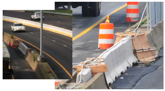
slide 16: Use of Movable Barrier
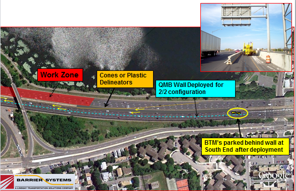
slide notes:
The need for positive protection to run counter-flow traffic and still be efficient to deploy, led MassDOT to the "Quick Change" barrier system.
slide 17: I-93 Crossover TMP
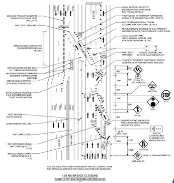
slide notes:
We developed specific TTCP's in cooperation with the State Police and Construction as they had years of experience with how ramp closures and lane drops work on both north and southbound I-93
slide 18: Work Zone Speed Limit
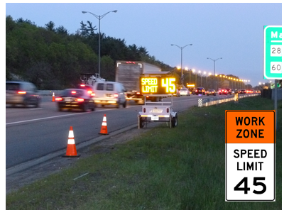
slide notes:
We decided that it was important to drop the regulatory Speed Limit within the limits of the TTCP and used Speed Feedback Message Boards to remind motorists
slide 19: Work Area Protection
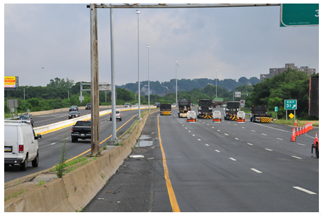
slide notes:
As a commitment to safety, we were serious about protecting the hard work zone and keeping traffic out and within the lanes/ramps open to travel
slide 20: Emergency Access Points
slide notes:
Having a 4.5 mile crossover behind barrier led us to add emergency access points a two locations for incident management
slide 21: Route 28 Traffic Plan
slide notes:
Route 28 served as the primary local access detour route and a Traffic Signal Progression timing plan was added to each of the 16 locations along the corridor. We also added two new controllers to be able to run the schedule
slide 22: Local Detour Routes
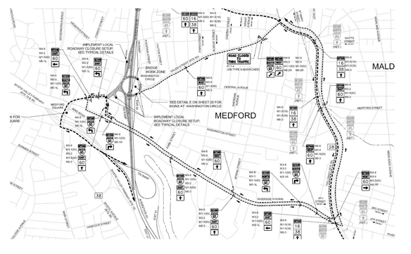
slide notes:
All local detour routes were presented to the local communities for review early in the process to ensure that we had full support and buy-in for the plans. We needed to provide multiple routes to address directional flow and spread out the volume impacts.
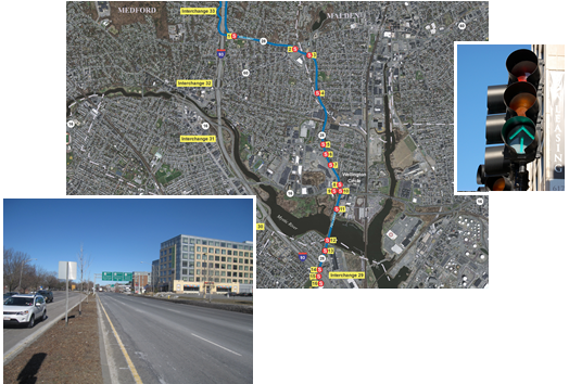
slide 23: Maps for Detour Routes
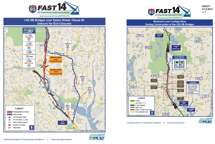
slide notes:
Working with our Public Outreach Team we created weekend specific/bridge specific detour route maps that were made available to the local communities and on the MassDOT Fast 14 project website
slide 24: Incident Command Center
- From early on in the process the decision was made to plan the Fast 14 traffic management operations as if the weekend schedule is an "incident" and utilize the Incident Command Structure according to the National Incident Management System (NIMS)
- The Massachusetts State Police have a mobile "command center" that will serve as the focal point of communications between work zone traffic details, intersection control, construction operations, local police/fire and of incidents and regional EMS
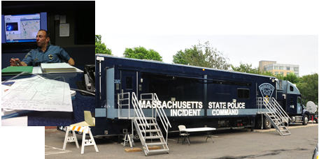
slide notes:
NIMS provides a systematic, proactive approach to guide departments and agencies at all levels of government, in the management of incidents
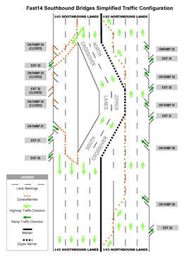
slide 25: I-93 Traffic Route Diagram
Diagrams created to assist State Police with simple layout of the traffic management plan displaying the lane/ramp status for use in fixed post assignment and quick emergency response
slide notes:
None
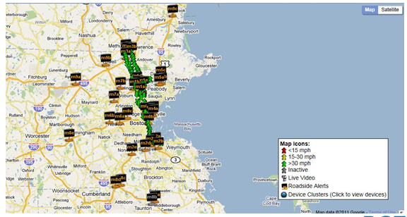
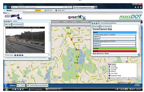
slide 26: Real-Time Traffic Management
slide notes:
Provide a public-facing and MassDOT administrative RTTM system website that is easy to use and understand
This is MassDOT's first large-scale "Smart Work Zone" project and we prepared a detailed specification for the project RFP
slide 27: RTTM Equipment
- 35 Portable Changeable Message Signs (PCMS)
- 4 Portable Camera Trailers
- 67 Traffic Sensor Trailers
- 3 Blue Tooth Sensors
- ASTI's "CHIPS" Program (Operating System)
slide notes:
Computerized Highway Information Processing System
slide 28: RTTM System
slide notes:
None
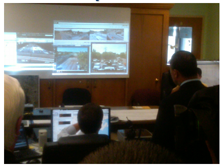
slide 29: Field Office Operations Center
slide notes:
None.
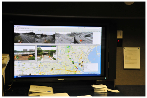
slide 30: Video Wall at Command Post
slide notes:
None
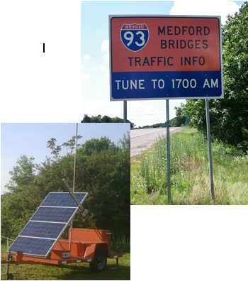
slide 31: Highway Advisory Radio
- MassDOT deployed six HAR units approaching key alternate routes
- Message sets were drafted for eight different traffic scenarios based on varying delay thresholds
slide notes:
None
slide 32: 511 Construction Updates
- Entering the final weekend (#10), there were 825 users of the dedicated I-93 Fast 14 Construction Alerts
- Saturday, July 30th – General Message
"MassDOT- Medford I93 reduced to 2 lanes each dir – NB Ramps open, SB to Ex 33 only. Local access via Rt 28. Expect traffic delays/plan extra time/use alt rtes" - Voice over – In addition to the traditional text messages that we send Sendza, we also prepare and send a local roadway detour plan
slide notes:
None.
slide 33: State Police Emergency Response Teams
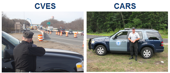
slide notes:
Project team held 4 meetings with 16 local Police Departments as a part of the process in developing the Contingency Plan and Incident Action Plan.
Team also conducted one big regional meeting with Armstrong Ambulance that included several other regional companies. In addition, there were coordination meetings with representatives from both Boston EMS and Massachusetts General Hospital (MGH).
The MSP Truck Team Commander held several discussions with the MSP Truck Team, Coady's and DEP to ensure that an agreement on an expedited version of the HazMat cleanup protocol was reached.
MSP Troop A worked with the Accident Recon Team (CARS) to develop an expedited accident reconstruction protocol to ensure a very quick cleanup and clearance for any accident involving a serious injury or fatality occurring within the Fast 14 Project boundary.
slide 34: On-Site Tow Services
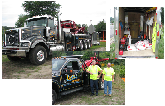
slide notes:
None.
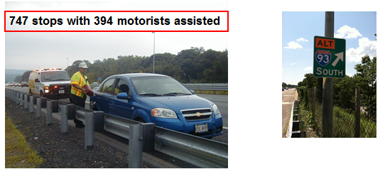
slide 35: Motorist Assistance Vans
In order to keep the "alternate routes" a viable option for motorists to consider diverting to, MassDOT scheduled the traditional weekday rush hour Motorist Assistance Vans to keep the road free from breakdowns and traffic incidents
slide notes:
None.
slide 36: Public Transportation
- Anderson RTC – People were encouraged to take advantage of the free parking
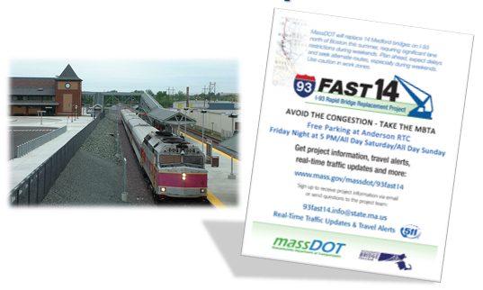
slide notes:
None.
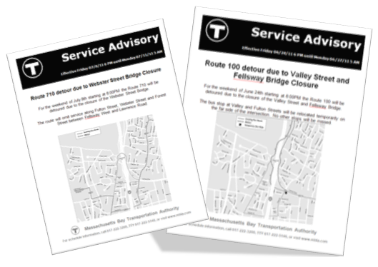
slide 37: Bus Route Changes
slide notes:
None
slide 38: Achievement of Project Goals
- Managed interstate traffic without long queues/excessive delays
- Kept local detour routes moving with acceptable levels of delay
- Protected workers from hazards of the work zone/highway
- Avoided serious crashes within the limits of the TTCP
slide notes:
None
slide 39: Questions?
Contact Information:
Neil Boudreau, State Traffic Engineer
MassDOT Highway Division
(857) 368-9655
neil.boudreau@state.ma.us
slide notes:
None
previous | next